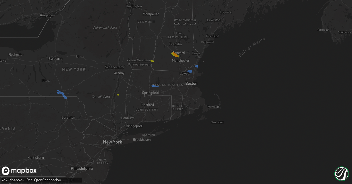
Hail Map in Massachusetts on July 23, 2020
Get this storm
July 23 map
$229
one time, instant access
Download today. No call, no setup
Keep the $229
Bought the map and want the full workflow? Apply the entire $229 to a subscription within 7 days. None of it is wasted.
Every map, not just this one
This buys you this map. Subscription and you get every map we run, in the markets you choose from a few cities to whole states to nationwide. Plus real-time alerts the moment a storm fires.
Contact data
Name, contact info, occupancy, even credit band for addresses in the footprint. You go from where it hit to who to call.
Become the source they trust
Unlimited branding weather history reports on demand. You already have the documented answer ready for the property owner, and you are the one who showed up with it.
Property data and RoofTrace estimates
Pull up any address you have got, its value and the exact code rules for that jurisdiction, straight from One Click Code. Then RoofTrace estimates the squares, pitch, and roof value, priced the way you price.
Storm reports in Massachusetts
Massachusetts
| Date | Description |
|---|---|
| 07/23/20204:50 PM CDT | Trees down |
| 07/23/20204:30 PM CDT | The top of a tree was downed and blocking part of pinewood rd in avon. |
| 07/23/20204:25 PM CDT | Power lines and a large tree branch downed on bennett st in wrentham. |
| 07/23/20204:25 PM CDT | Tree down on randolph st. |
| 07/23/20204:20 PM CDT | Tree down on lisa dr |
| 07/23/20204:20 PM CDT | Tree down on moore ave in franklin. |
| 07/23/20204:20 PM CDT | Tree downed on philomena way in franklin. |
| 07/23/20204:15 PM CDT | Wires and a large branch downed on court st in winthrop. |
| 07/23/20204:05 PM CDT | Tree down. |
| 07/23/20204:05 PM CDT | Tree down on power lines on hemlock st in douglas. |
| 07/23/20203:50 PM CDT | Tree down and blocking fellsway east. |
| 07/23/20203:50 PM CDT | Power lines down at milton avenue and rockwell street. |
| 07/23/20203:45 PM CDT | Three large trees down into the back part of an apartment house on wilkins glen road. |
| 07/23/20203:40 PM CDT | Large tree down on a house on southwick road. Two wires down. |
| 07/23/20203:39 PM CDT | Tree down on wires on ripley street. |
| 07/23/20203:39 PM CDT | Tree down on burke lane by mclean street. |
| 07/23/20203:35 PM CDT | Large tree down on wires blocking one lane of central street. |
| 07/23/20203:35 PM CDT | Tree down on west hartford avenue. |
| 07/23/20203:32 PM CDT | Two trees down on flaxfield road. One tree down on a house on flaxfield road. |
| 07/23/20203:28 PM CDT | Multiple wires down on school street. |
| 07/23/20203:28 PM CDT | Tree down on state route 30 at ash street. Tree down on a car on route 30 at high meadow road. |
| 07/23/20202:37 PM CDT | Tree down on mountain road. |
| 07/23/20202:15 PM CDT | Tree down on pleasant valley road |
| 07/23/20202:15 PM CDT | Tree down on essex street and partially blocking the road. |
| 07/23/20202:10 PM CDT | Tree down blocking lowell road |
| 07/23/20202:10 PM CDT | Tree down on wires on chandler road. Tree down on wires on greenwood road. |
| 07/23/20201:52 PM CDT | Tree down blocking warren wright road. |
| 07/23/20201:40 PM CDT | Harris street and surrounding streets have several trees and large limbs down. |
| 07/23/20201:11 PM CDT | Tree and wires down... Hamilton street at lincoln avenue. |
| 07/23/20201:49 AM CDT | At 649 PM EDT, a severe thunderstorm was located over Norfolk, or 9 miles north of Torrington, moving east at 15 mph. HAZARD...60 mph wind gusts and quarter size hail. SOURCE...Radar indicated. IMPACT...Hail damage to vehicles is expected. Expect wind damage to roofs, siding, and trees. Locations impacted include... Torrington, New Hartford, Norfolk, Winsted, New Hartford Center, Northwest Harwinton, Harwinton, Barkhamsted, Goshen, Colebrook, South Norfolk, West Torrington, Torringford, Mooreville, Nepaug, North Colebrook, Riverton, Kelly Corner, Mill Brook and West Goshen. |
| 07/23/20201:34 AM CDT | At 634 PM EDT, a severe thunderstorm was located over Carver, or near Plymouth, moving east at 25 mph. HAZARD...60 mph wind gusts and penny size hail. SOURCE...Radar indicated. IMPACT...Expect damage to trees and power lines. Locations impacted include... Plymouth, Middleborough, Wareham, Sandwich, Bourne, Kingston, Carver and Plympton. |
| 07/23/20201:31 AM CDT | At 630 PM EDT, a severe thunderstorm was located near Livingston, or 10 miles southeast of Catskill, moving southeast at 15 mph. HAZARD...60 mph wind gusts. SOURCE...Radar indicated. IMPACT...Expect damage to roofs, siding, and trees. Locations impacted include... Livingston, Copake, Pine Plains, Clermont, Ancram, Canaan, Ashley Falls, Bethel, Hillsdale, Taghkanic, Whitehouse Crossing, Pachin Mills, Ancramdale, Weed Mines, Craryville, Mount Riga, Nevis, Alander, Taconic and Silvernails. |
| 07/22/202011:45 PM CDT | At 445 PM EDT, a severe thunderstorm was located over Millis, or near Natick, moving east at 30 mph. HAZARD...60 mph wind gusts and quarter size hail. SOURCE...Radar indicated. IMPACT...Expect wind damage to trees and power lines. Minor hail damage to vehicles is possible. Locations impacted include... Boston, Brockton, Quincy, Weymouth, Braintree, Randolph, Franklin, Norwood, Milton, Stoughton, Marshfield, Dedham, Walpole, Hingham, Canton, Scituate, Pembroke, Sharon, Rockland and Ashland. |
| 07/22/202011:33 PM CDT | At 433 PM EDT, a severe thunderstorm was located over Watertown, moving east at 30 mph. HAZARD...60 mph wind gusts and penny size hail. SOURCE...Radar indicated. IMPACT...Expect damage to trees and power lines. Locations impacted include... Boston, Cambridge, Quincy, Lynn, Newton, Somerville, Waltham, Malden, Brookline, Medford, Weymouth, Revere, Arlington, Everett, Salem, Woburn, Chelsea, Watertown, Lexington and Needham. |
| 07/22/202011:19 PM CDT | At 419 PM EDT, a severe thunderstorm was located over Framingham, moving east at 30 mph. HAZARD...60 mph wind gusts and quarter size hail. SOURCE...Radar indicated. IMPACT...Expect wind damage to trees and power lines. Minor hail damage to vehicles is possible. Locations impacted include... Newton, Framingham, Waltham, Marlborough, Natick, Lexington, Needham, Wellesley, Dedham, Hudson, Westborough, Concord, Sudbury, Ashland, Hopkinton, Westwood, Holliston, Bedford, Wayland and Weston. |
| 07/22/202011:01 PM CDT | At 401 PM EDT, a severe thunderstorm was located over West Sand Lake, or near East Greenbush, moving east at 25 mph. HAZARD...60 mph wind gusts. SOURCE...Radar indicated. IMPACT...Expect damage to roofs, siding, and trees. Locations impacted include... East Greenbush, Rensselaer, Nassau, Stephentown, Castleton-On-Hudson, West Sand Lake, Averill Park, Selkirk, Wynantskill, North Greenbush, Sand Lake, Poestenkill, East Nassau, Brookview, Van Hoesen Station, West Stephentown, Jacks Corners, Beckers Corners, Millers Corners and Taborton. |
| 07/22/202010:20 PM CDT | At 319 PM EDT, a severe thunderstorm was located over Princeton, or 7 miles southwest of Leominster, moving east at 25 mph. HAZARD...60 mph wind gusts and quarter size hail. SOURCE...Radar indicated. IMPACT...Expect wind damage to trees and power lines. Minor hail damage to vehicles is possible. Locations impacted include... Leominster, Fitchburg, Marlborough, Acton, Gardner, Hudson, Sudbury, Holden, Clinton, Pepperell, Groton, Maynard, Lunenburg, Townsend, Littleton, Lancaster, Rutland, Sterling, West Boylston and Ayer. |
| 07/22/20209:56 PM CDT | At 256 PM EDT, a severe thunderstorm was located near Norfolk, or 12 miles southeast of Great Barrington, moving southeast at 25 mph. HAZARD...60 mph wind gusts. SOURCE...Radar indicated. IMPACT...Expect damage to roofs, siding, and trees. Locations impacted include... New Hartford, Norfolk, Canaan, Sandisfield, Winsted, New Hartford Center, Ashley Falls, Barkhamsted, New Marlborough, Colebrook, Monterey, Sodom, Hartsville, Mooreville, Konkapot, Wangum Village, Gomorrah, Mill Brook, Montville and Beech Rock. |
All States Impacted by Hail Map on July 23, 2020
Cities Impacted by Hail Map on July 23, 2020
- Dunbarton, NH
- Weare, NH
- Bow, NH
- Contoocook, NH
- Hooksett, NH
- Henniker, NH
- Jordan Valley, OR
- Buffalo, SD
- Reva, SD
- Camp Crook, SD
- Interior, SD
- Kadoka, SD
- Prairie City, SD
- Marmarth, ND
- Bruneau, ID
- Grand View, ID
- Boise, ID
- Elizaville, NY
- Tivoli, NY
- Red Hook, NY
- Endicott, NY
- Johnson City, NY
- Great Bend, PA
- Binghamton, NY
- Conklin, NY
- Vestal, NY
- Susquehanna, PA
- Hallstead, PA
- Surgoinsville, TN
- Church Hill, TN
- Rogersville, TN
- Elizabethton, TN
- Roan Mountain, TN
- Unicoi, TN
- Hampton, TN
- Johnson City, TN
- Jonesborough, TN
- Erwin, TN
- Molt, MT
- Columbus, MT
- Park City, MT
- Reed Point, MT
- Big Timber, MT
- Coffee Creek, MT
- Geraldine, MT
- Outlook, MT
- Plentywood, MT
- Westmoreland, NH
- Putney, VT
- Newburyport, MA
- Salisbury, MA
- Newbury, MA
- Amherst, MA
- Belchertown, MA
- Granby, MA
- Ware, MA
- South Hadley, MA
- Andover, MA
- Lawrence, MA
- Boxford, MA
- Methuen, MA
- North Andover, MA
- Glendive, MT
- Wibaux, MT
- Baker, MT
- Larslan, MT
- Peerless, MT
- Frazer, MT
- Greensboro, NC
- Maxbass, ND
- Westhope, ND
- Upham, ND
- Kramer, ND
- Lansford, ND
- Souris, ND
- Newburg, ND
- Glenburn, ND
- Berthold, ND
- Scobey, MT
- Riverside, OR
- Plaza, ND
- Parshall, ND
- Ryder, ND
- Wellington, TX
- Port Haywood, VA
- Onemo, VA
- Yucca, AZ
- Wray, CO
- Haigler, NE
- Matador, TX
- Redstone, MT
- Wolf Point, MT
- Tioga, ND
- Des Lacs, ND
- Miami, TX
- Dickens, TX
- Afton, TX
- Grimesland, NC
- Washington, NC
- Teasdale, UT
- Norfolk, CT
- Carpio, ND
- Parksley, VA
- Bloxom, VA
- Goffstown, NH
- Manchester, NH
- Lillington, NC
- Pinckneyville, IL
- Cutler, IL
- Belle Fourche, SD
- Sainte Genevieve, MO
- Germantown, NY
- Ancram, NY
- Hudson, NY
- Shamrock, TX
- Saint Francis, KS
- Stratton, CO
- Bethune, CO
- Skull Valley, AZ
- Bowbells, ND
- Murphy, ID
- Barhamsville, VA
- Sunbury, NC
- Hobbsville, NC
- Vale, NC
- Wendell, NC
- Snyder, TX
- Mclean, TX
- Alamo, ND
- Ray, ND
- Epping, ND
- Flaxton, ND
- Dillon, MT
- Spencer, VA
- Martinsville, VA
- Supai, AZ
- Palermo, ND
- Stanley, ND
- Donnybrook, ND
- Waterloo, IL
- Weatherford, OK
- Williston, ND
- Aspermont, TX
- Dagmar, MT
- Medicine Lake, MT
- Sherwood, ND
- Tolley, ND
- Kenmare, ND
- Kirkland, AZ
- Reserve, MT
- Burlington, ND
- Richey, MT
- Paducah, TX
- Lignite, ND
- Turkey, TX
- Merry Hill, NC
- Blackfoot, ID
- Roxbury, MA
- Boston, MA
- Roxbury Crossing, MA
- Minot Afb, ND
- Bottineau, ND
- Savage, MT
- Newell, SD
- Conowingo, MD
- Colora, MD
- Williams, AZ
- Hanksville, UT
- Thompsonville, IL
- Edenton, NC
- West Point, KY
- Bulls Gap, TN
- Greeneville, TN
- Spring Hope, NC
- Williamston, NC
- Crosbyton, TX
- Weinert, TX
- Mohall, ND
- Falls Village, CT
- Hillsboro, MO
- Rocky Hill, NJ
- Princeton, NJ
- Belle Mead, NJ
- Skillman, NJ
- Red Bud, IL
- Evansville, IL
- Duchesne, UT
- Nortonville, KY
- West Memphis, AR
- Zebulon, NC
- Middlesex, NC
- Ava, IL
- Oxford, NC
- Powers Lake, ND
- Lambert, MT
- Bloomfield, MT
- Dell, MT
- Lima, MT
- Washington, DC
- Lansdale, PA
- Hatfield, PA
- Sedgewickville, MO
- Perryville, MO
- Whitakers, NC
- Newsoms, VA
- Courtland, VA
- Bremen, KY
- Monument Valley, UT
- Lexington, NC
- Thomasville, NC
- Sanford, NC
- Moncure, NC
- Nashville, NC
- Sidney, MT
- Fairview, MT
- Craryville, NY
- Piscataway, NJ
- Rhinebeck, NY
- Port Ewen, NY
- Ulster Park, NY
- Staatsburg, NY
- Carthage, TN
- Pleasant Shade, TN
- Louisburg, NC
- Bunn, NC
- Patrick Springs, VA
- Bassett, VA
- Fieldale, VA
- Unionville, TN
- Selmer, TN
- Stantonville, TN
- Ludlow, SD
- Claverack, NY
- Hollowville, NY
- Hillsdale, NY
- Burlington, CO
- Elkton, MD
- Firth, ID
- Virginia Beach, VA
- Hertford, NC
- Kenly, NC
- Fremont, NC
- Bloomsdale, MO
- Linden, NC
- Bunnlevel, NC
- Makoti, ND
- Dayton, NJ
- Matawan, NJ
- South Amboy, NJ
- Old Bridge, NJ
- Spotswood, NJ
- East Brunswick, NJ
- Englishtown, NJ
- Monroe Township, NJ
- Morganville, NJ
- Sayreville, NJ
- Helmetta, NJ
- Montauk, NY
- West Frankfort, IL
- Prairie Du Rocher, IL
- Fults, IL
- Baldwin, IL
- Memphis, TN
- Watonga, OK
- Hitchcock, OK
- Lenoir City, TN
- Grady, NM
- Tucumcari, NM
- Froid, MT
- Bainville, MT
- Holyoke, CO
- Ayer, MA
- South Boston, MA
- Dorchester, MA
- Elizabeth City, NC
- Fuquay Varina, NC
- Williamsburg, VA
- Spring Grove, VA
- Roaring River, NC
- Plymouth, NC
- Whiteville, TN
- Middleton, TN
- Hermleigh, TX
- Poplar, MT
- Arlington, VA
- Alexandria, VA
- Vernon, CO
- Parks, NE
- Bridgewater, NJ
- Somerville, NJ
- Sedley, VA
- Zuni, VA
- Ivor, VA
- Franklin, VA
- Clinton, NC
- Culbertson, MT
- Coalville, UT
- Holmdel, NJ
- Lincroft, NJ
- Colts Neck, NJ
- Battletown, KY
- Pikeville, KY
- Gatesville, NC
- Tyner, NC
- Belvidere, NC
- Eagleville, TN
- Rockvale, TN
- Chocowinity, NC
- Rexburg, ID
- Boulder, MT
- Stanley, ID
- Milltown, NJ
- North Brunswick, NJ
- Robbinsville, NJ
- Millstone Township, NJ
- Allentown, NJ
- Auburn, NH
- Bradford, NH
- Warner, NH
- Mountain Home Afb, ID
- West Point, VA
- Montross, VA
- Winton, NC
- Eure, NC
- Central City, KY
- Smithfield, NC
- Ahoskie, NC
- Shannon, NC
- Red Springs, NC
- Broadway, NC
- Thomas, OK
- Elida, NM


