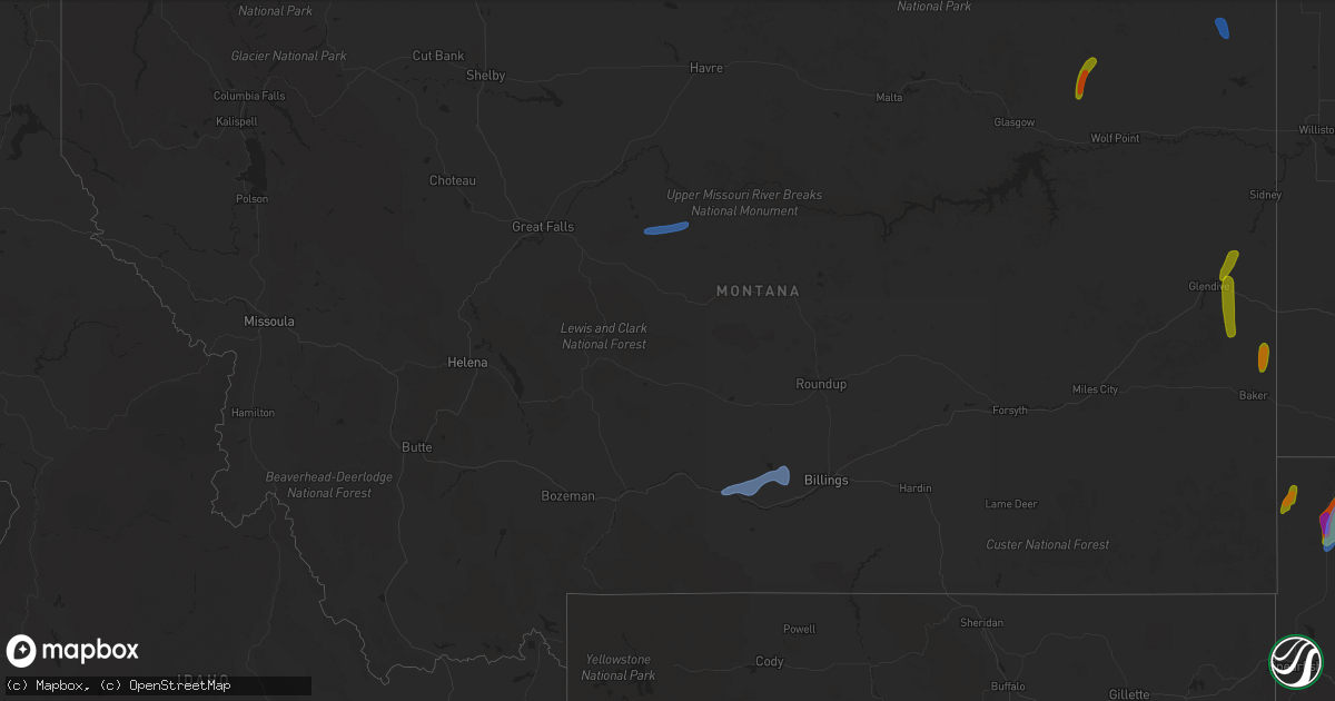
Hail Map in Montana on July 23, 2020
Get this storm
July 23 map
$229
one time, instant access
Download today. No call, no setup
Keep the $229
Bought the map and want the full workflow? Apply the entire $229 to a subscription within 7 days. None of it is wasted.
Every map, not just this one
This buys you this map. Subscription and you get every map we run, in the markets you choose from a few cities to whole states to nationwide. Plus real-time alerts the moment a storm fires.
Contact data
Name, contact info, occupancy, even credit band for addresses in the footprint. You go from where it hit to who to call.
Become the source they trust
Unlimited branding weather history reports on demand. You already have the documented answer ready for the property owner, and you are the one who showed up with it.
Property data and RoofTrace estimates
Pull up any address you have got, its value and the exact code rules for that jurisdiction, straight from One Click Code. Then RoofTrace estimates the squares, pitch, and roof value, priced the way you price.
Storm reports in Montana
Montana
| Date | Description |
|---|---|
| 07/23/20206:49 PM CDT | Awos station k1dm... Delta. |
| 07/23/20206:40 PM CDT | Peeled lots of shingles off roof and lots of debris flying around. |
| 07/23/20206:35 PM CDT | 60 mph wind gust at brenner raws. Time of event is estimated. |
| 07/23/20206:20 PM CDT | Received delayed report and photos from storm... Time estimated from radar and size estimated from photos received. |
| 07/23/20206:20 PM CDT | Reports strong winds created blowing dust with zero visibility at times. Based on sway of trees estimated 60 mph winds. Time estimated based on radar. |
| 07/23/20206:04 PM CDT | A local report indicates 58 MPH wind near JUDITH GAP |
| 07/23/20205:40 PM CDT | A local report indicates 61 MPH wind near 2 SSW BIG TIMBER |
| 07/23/20205:30 PM CDT | Corrects previous hail report from 5 w carlyle. Largest stones ping pong... Most were closer to quarters. Strong winds... Estimates around 50 mph... Plus 0.25 inches of |
| 07/23/20205:25 PM CDT | Largest stones ping pong... Most were closer to quarters. Strong winds... Estimates around 50 mph... Plus 0.25 inches of rain. |
| 07/23/20205:00 PM CDT | A local report indicates 75 MPH wind near 7 NE BAKER |
| 07/23/20204:40 PM CDT | Part of a tree and a power line are in the street at the 200 block of central ave south of white sulphur springs. Time was estimated based off of highest wind gust at t |
| 07/23/20204:38 PM CDT | 61 mph wind gust on bozeman pass. |
| 07/23/20204:13 PM CDT | Noticed a neighbor a couple blocks away had a 30 foot pine tree blown down with another tree leaning. |
| 07/23/20203:40 AM CDT | At 840 PM MDT, a severe thunderstorm was located 7 miles northwest of Bredette, or 15 miles south of Scobey, moving northeast at 10 mph. HAZARD...60 mph wind gusts and quarter size hail. SOURCE...Radar indicated. IMPACT...Hail damage to vehicles is expected. Expect wind damage to roofs, siding, and trees. This severe thunderstorm will remain over mainly rural areas of southeastern Daniels and north central Roosevelt Counties. |
| 07/23/20202:39 AM CDT | At 738 PM MDT, a severe thunderstorm was located 11 miles northwest of Grenora, or 19 miles east of Plentywood, moving north at 40 mph. HAZARD...60 mph wind gusts and quarter size hail. SOURCE...Radar indicated. IMPACT...Hail damage to vehicles is expected. Expect wind damage to roofs, siding, and trees. Locations impacted include... Westby, Comertown, Dagmar and Coalridge. |
| 07/23/20202:08 AM CDT | At 708 PM MDT, a severe thunderstorm was located near Archer, or 8 miles west of Plentywood, moving north at 30 mph. HAZARD...60 mph wind gusts and quarter size hail. SOURCE...Radar indicated. IMPACT...Hail damage to vehicles is expected. Expect wind damage to roofs, siding, and trees. Locations impacted include... Plentywood, Redstone, Archer, Port Of Raymond, Outlook, Reserve, Raymond, Dooley, Daleview, Antelope and Comertown. |
| 07/23/202012:46 AM CDT | At 546 PM MDT, a severe thunderstorm was located near Lustre, or 30 miles northwest of Wolf Point, moving northeast at 30 mph. HAZARD...60 mph wind gusts and quarter size hail. SOURCE...Radar indicated. IMPACT...Hail damage to vehicles is expected. Expect wind damage to roofs, siding, and trees. Locations impacted include... Peerless, West Fork and Four Buttes. |
| 07/23/202012:18 AM CDT | At 518 PM MDT, severe thunderstorms were located along a line extending from 10 miles south of Stanford to near Hobson to 20 miles southeast of Moore, moving east at 20 mph. HAZARD...60 mph wind gusts and penny size hail. SOURCE...Radar indicated. IMPACT...Expect damage to roofs, siding, and trees. Locations impacted include... Hobson, Moore, Windham, Moccasin, Ackley Lake State Park, Glengarry, Utica, Buffalo, Garneill and Benchland. |
| 07/23/202012:10 AM CDT | At 508 PM MDT, severe thunderstorms were located along a line extending from near Deadmans Basin Reservoir to near Absarokee, moving east at 50 mph. HAZARD...60 mph wind gusts. SOURCE...Radar indicated. A wind gust of 61 mph was reported at the Big Timber Airport at 4:40 PM MDT. IMPACT...Expect damage to roofs, siding, and trees. Locations impacted include... Columbus, Harlowton, Bridger, Joliet, Fromberg, Ryegate, Deadmans Basin Reservoir, Absarokee, Lavina, Franklin, Reed Point, Halfbreed Lake Wildlife, Edgar, Cooney Reservoir State Park, Park City, Rockvale, Nye, Fishtail, Boyd and Shawmut. |
| 07/22/202011:53 PM CDT | At 453 PM MDT, a severe thunderstorm was located 9 miles southeast of Carlyle, or 18 miles northeast of Baker, moving north at 15 mph. HAZARD...Ping pong ball size hail and 60 mph wind gusts. SOURCE...Radar indicated. IMPACT...People and animals outdoors will be injured. Expect hail damage to roofs, siding, windows, and vehicles. Expect wind damage to roofs, siding, and trees. This severe thunderstorm will be near... Golva around 540 PM MDT.Other locations impacted by this severe thunderstorm include Alphaand Three V Crossing. |
| 07/22/202011:07 PM CDT | At 407 PM MDT, a severe thunderstorm was located 6 miles northwest of Marmarth, or 12 miles east of Baker, moving northeast at 25 mph. HAZARD...60 mph wind gusts and half dollar size hail. SOURCE...Radar indicated. IMPACT...Hail damage to vehicles is expected. Expect wind damage to roofs, siding, and trees. This severe thunderstorm will be near... Marmarth around 410 PM MDT.Other locations impacted by this severe thunderstorm include PrettyButte and Three V Crossing. |
| 07/22/202011:04 PM CDT | At 403 PM MDT, a severe thunderstorm was located 7 miles southeast of Cascade, moving northeast at 30 mph. HAZARD...60 mph wind gusts. SOURCE...Radar indicated. IMPACT...Expect damage to roofs, siding, and trees. Locations impacted include... western portions of Great Falls, Cascade, Eden and Ulm. |
| 07/22/202010:31 PM CDT | At 330 PM MDT, a severe thunderstorm was located 18 miles southwest of Wibaux, moving north at 35 mph. HAZARD...60 mph wind gusts and quarter size hail. SOURCE...Radar indicated. IMPACT...Hail damage to vehicles is expected. Expect wind damage to roofs, siding, and trees. Locations impacted include... Glendive, Wibaux, Intake, West Glendive, Hoyt, Hodges, Forest Park, Stipek and Yates. |
| 07/22/20208:30 PM CDT | Trained spotter reported 3 large spruce trees 65 to 70 feet tall and 1 cottonwood blown down by thunderstorm winds. Wind estimated at 75mph. |
| 07/22/20208:20 PM CDT | Emergency prep coordinator at local hospital reports small outbuildings taken down by winds... Along with small trees and some power lines throughout town. |
| 07/22/20208:20 PM CDT | Mesonet station ggwpw 1.8 e plentywood |
| 07/22/20208:15 PM CDT | Sheridan county asst. Des coordinator reports 65-70 mph winds currently. |
| 07/22/20208:15 PM CDT | Shingles being torn off roof in plentywood and being thrown into backyard. |
| 07/22/20208:10 PM CDT | Several trees were blown over... Limbs broken off... Leaves tore off. Time estimated from radar. |
| 07/22/20207:38 PM CDT | Also witnessed by nws employee. |
All States Impacted by Hail Map on July 23, 2020
Cities Impacted by Hail Map on July 23, 2020
- Dunbarton, NH
- Weare, NH
- Bow, NH
- Contoocook, NH
- Hooksett, NH
- Henniker, NH
- Jordan Valley, OR
- Buffalo, SD
- Reva, SD
- Camp Crook, SD
- Interior, SD
- Kadoka, SD
- Prairie City, SD
- Marmarth, ND
- Bruneau, ID
- Grand View, ID
- Boise, ID
- Elizaville, NY
- Tivoli, NY
- Red Hook, NY
- Endicott, NY
- Johnson City, NY
- Great Bend, PA
- Binghamton, NY
- Conklin, NY
- Vestal, NY
- Susquehanna, PA
- Hallstead, PA
- Surgoinsville, TN
- Church Hill, TN
- Rogersville, TN
- Elizabethton, TN
- Roan Mountain, TN
- Unicoi, TN
- Hampton, TN
- Johnson City, TN
- Jonesborough, TN
- Erwin, TN
- Molt, MT
- Columbus, MT
- Park City, MT
- Reed Point, MT
- Big Timber, MT
- Coffee Creek, MT
- Geraldine, MT
- Outlook, MT
- Plentywood, MT
- Westmoreland, NH
- Putney, VT
- Newburyport, MA
- Salisbury, MA
- Newbury, MA
- Amherst, MA
- Belchertown, MA
- Granby, MA
- Ware, MA
- South Hadley, MA
- Andover, MA
- Lawrence, MA
- Boxford, MA
- Methuen, MA
- North Andover, MA
- Glendive, MT
- Wibaux, MT
- Baker, MT
- Larslan, MT
- Peerless, MT
- Frazer, MT
- Greensboro, NC
- Maxbass, ND
- Westhope, ND
- Upham, ND
- Kramer, ND
- Lansford, ND
- Souris, ND
- Newburg, ND
- Glenburn, ND
- Berthold, ND
- Scobey, MT
- Riverside, OR
- Plaza, ND
- Parshall, ND
- Ryder, ND
- Wellington, TX
- Port Haywood, VA
- Onemo, VA
- Yucca, AZ
- Wray, CO
- Haigler, NE
- Matador, TX
- Redstone, MT
- Wolf Point, MT
- Tioga, ND
- Des Lacs, ND
- Miami, TX
- Dickens, TX
- Afton, TX
- Grimesland, NC
- Washington, NC
- Teasdale, UT
- Norfolk, CT
- Carpio, ND
- Parksley, VA
- Bloxom, VA
- Goffstown, NH
- Manchester, NH
- Lillington, NC
- Pinckneyville, IL
- Cutler, IL
- Belle Fourche, SD
- Sainte Genevieve, MO
- Germantown, NY
- Ancram, NY
- Hudson, NY
- Shamrock, TX
- Saint Francis, KS
- Stratton, CO
- Bethune, CO
- Skull Valley, AZ
- Bowbells, ND
- Murphy, ID
- Barhamsville, VA
- Sunbury, NC
- Hobbsville, NC
- Vale, NC
- Wendell, NC
- Snyder, TX
- Mclean, TX
- Alamo, ND
- Ray, ND
- Epping, ND
- Flaxton, ND
- Dillon, MT
- Spencer, VA
- Martinsville, VA
- Supai, AZ
- Palermo, ND
- Stanley, ND
- Donnybrook, ND
- Waterloo, IL
- Weatherford, OK
- Williston, ND
- Aspermont, TX
- Dagmar, MT
- Medicine Lake, MT
- Sherwood, ND
- Tolley, ND
- Kenmare, ND
- Kirkland, AZ
- Reserve, MT
- Burlington, ND
- Richey, MT
- Paducah, TX
- Lignite, ND
- Turkey, TX
- Merry Hill, NC
- Blackfoot, ID
- Roxbury, MA
- Boston, MA
- Roxbury Crossing, MA
- Minot Afb, ND
- Bottineau, ND
- Savage, MT
- Newell, SD
- Conowingo, MD
- Colora, MD
- Williams, AZ
- Hanksville, UT
- Thompsonville, IL
- Edenton, NC
- West Point, KY
- Bulls Gap, TN
- Greeneville, TN
- Spring Hope, NC
- Williamston, NC
- Crosbyton, TX
- Weinert, TX
- Mohall, ND
- Falls Village, CT
- Hillsboro, MO
- Rocky Hill, NJ
- Princeton, NJ
- Belle Mead, NJ
- Skillman, NJ
- Red Bud, IL
- Evansville, IL
- Duchesne, UT
- Nortonville, KY
- West Memphis, AR
- Zebulon, NC
- Middlesex, NC
- Ava, IL
- Oxford, NC
- Powers Lake, ND
- Lambert, MT
- Bloomfield, MT
- Dell, MT
- Lima, MT
- Washington, DC
- Lansdale, PA
- Hatfield, PA
- Sedgewickville, MO
- Perryville, MO
- Whitakers, NC
- Newsoms, VA
- Courtland, VA
- Bremen, KY
- Monument Valley, UT
- Lexington, NC
- Thomasville, NC
- Sanford, NC
- Moncure, NC
- Nashville, NC
- Sidney, MT
- Fairview, MT
- Craryville, NY
- Piscataway, NJ
- Rhinebeck, NY
- Port Ewen, NY
- Ulster Park, NY
- Staatsburg, NY
- Carthage, TN
- Pleasant Shade, TN
- Louisburg, NC
- Bunn, NC
- Patrick Springs, VA
- Bassett, VA
- Fieldale, VA
- Unionville, TN
- Selmer, TN
- Stantonville, TN
- Ludlow, SD
- Claverack, NY
- Hollowville, NY
- Hillsdale, NY
- Burlington, CO
- Elkton, MD
- Firth, ID
- Virginia Beach, VA
- Hertford, NC
- Kenly, NC
- Fremont, NC
- Bloomsdale, MO
- Linden, NC
- Bunnlevel, NC
- Makoti, ND
- Dayton, NJ
- Matawan, NJ
- South Amboy, NJ
- Old Bridge, NJ
- Spotswood, NJ
- East Brunswick, NJ
- Englishtown, NJ
- Monroe Township, NJ
- Morganville, NJ
- Sayreville, NJ
- Helmetta, NJ
- Montauk, NY
- West Frankfort, IL
- Prairie Du Rocher, IL
- Fults, IL
- Baldwin, IL
- Memphis, TN
- Watonga, OK
- Hitchcock, OK
- Lenoir City, TN
- Grady, NM
- Tucumcari, NM
- Froid, MT
- Bainville, MT
- Holyoke, CO
- Ayer, MA
- South Boston, MA
- Dorchester, MA
- Elizabeth City, NC
- Fuquay Varina, NC
- Williamsburg, VA
- Spring Grove, VA
- Roaring River, NC
- Plymouth, NC
- Whiteville, TN
- Middleton, TN
- Hermleigh, TX
- Poplar, MT
- Arlington, VA
- Alexandria, VA
- Vernon, CO
- Parks, NE
- Bridgewater, NJ
- Somerville, NJ
- Sedley, VA
- Zuni, VA
- Ivor, VA
- Franklin, VA
- Clinton, NC
- Culbertson, MT
- Coalville, UT
- Holmdel, NJ
- Lincroft, NJ
- Colts Neck, NJ
- Battletown, KY
- Pikeville, KY
- Gatesville, NC
- Tyner, NC
- Belvidere, NC
- Eagleville, TN
- Rockvale, TN
- Chocowinity, NC
- Rexburg, ID
- Boulder, MT
- Stanley, ID
- Milltown, NJ
- North Brunswick, NJ
- Robbinsville, NJ
- Millstone Township, NJ
- Allentown, NJ
- Auburn, NH
- Bradford, NH
- Warner, NH
- Mountain Home Afb, ID
- West Point, VA
- Montross, VA
- Winton, NC
- Eure, NC
- Central City, KY
- Smithfield, NC
- Ahoskie, NC
- Shannon, NC
- Red Springs, NC
- Broadway, NC
- Thomas, OK
- Elida, NM


