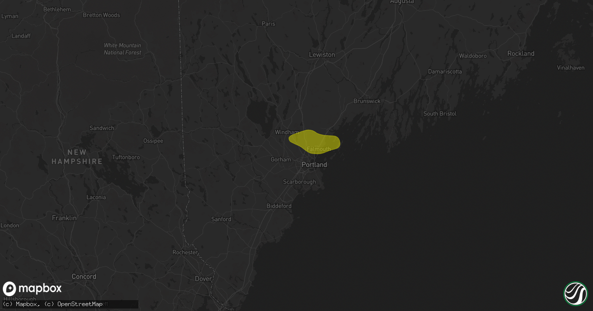
Hail Map in Westbrook, ME on July 20, 2025
Get this storm
July 20 map
$229
one time, instant access
Download today. No call, no setup
Keep the $229
Bought the map and want the full workflow? Apply the entire $229 to a subscription within 7 days. None of it is wasted.
Every map, not just this one
This buys you this map. Subscription and you get every map we run, in the markets you choose from a few cities to whole states to nationwide. Plus real-time alerts the moment a storm fires.
Contact data
Name, contact info, occupancy, even credit band for addresses in the footprint. You go from where it hit to who to call.
Become the source they trust
Unlimited branding weather history reports on demand. You already have the documented answer ready for the property owner, and you are the one who showed up with it.
Property data and RoofTrace estimates
Pull up any address you have got, its value and the exact code rules for that jurisdiction, straight from One Click Code. Then RoofTrace estimates the squares, pitch, and roof value, priced the way you price.
Storm reports in Westbrook, ME
Westbrook, ME
| Date | Description |
|---|---|
| 07/20/20253:43 PM CDT | Delayed report: multiple trees down in the meicher court and railway avenue area of westbrook. One tree fell into a home. |
| 07/20/20251:56 PM CDT | Multiple trees down on houses along route 302 in windham... Just in from the westbrook line. |
All States Impacted by Hail Map on July 20, 2025
All Cities Impacted by Hail Map on July 20, 2025
- McDonald, KS
- Bird City, KS
- Atwood, KS
- Weskan, KS
- Sharon Springs, KS
- Stockton, KS
- Plainville, KS
- Natoma, KS
- Gray, ME
- Cumberland Center, ME
- Windham, ME
- Falmouth, ME
- Westbrook, ME
- Portland, ME
- Cumberland Foreside, ME
- Yarmouth, ME
- Chebeague Island, ME
- Wessington Springs, SD
- Alpena, SD
- Woonsocket, SD
- Artesian, SD
- Letcher, SD
- Wessington, SD
- Mitchell, SD
- Fulton, SD
- Jordan, MT
- Orlando, FL
- Christmas, FL
- Medora, ND
- White River, SD
- Cody, NE
- Kilgore, NE
- Nenzel, NE
- Belfield, ND
- Norris, SD
- South Heart, ND
- Flagler, CO
- Dickinson, ND
- New England, ND
- Valentine, NE
- Kinsey, MT
- Miles City, MT
- Ismay, MT
- Terry, MT
- Lefor, ND
- Parmelee, SD
- Gladstone, ND
- Saint Francis, SD
- Fallon, MT
- Regent, ND
- Rosebud, SD
- Joes, CO
- Cope, CO
- Bowman, ND
- Amidon, ND
- Mott, ND
- Midland, SD
- Belvidere, SD
- Kadoka, SD
- Mission, SD
- Crookston, NE
- Saint Francis, KS
- Garryowen, MT
- Lodge Grass, MT
- Golva, ND
- Sentinel Butte, ND
- Beach, ND
- Long Valley, SD
- Wood Lake, NE
- Baker, MT
- Plevna, MT
- Mandan, ND
- Rhame, ND
- Camp Crook, SD
- Thedford, NE
- Johnstown, NE
- Buffalo, SD
- Otter, MT
- Olive, MT
- Broadus, MT
- Hugo, CO
- Biddle, MT
- Reeder, ND
- Scranton, ND
- Hettinger, ND
- Moffit, ND
- Ainsworth, NE
- Boyes, MT
- Hammond, MT
- Alzada, MT
- Haswell, CO
- Eads, CO
- Center Conway, NH
- Conway, NH
- Madison, NH
- Grafton, NH
- Springfield, NH
- Danbury, NH
- Wilmot, NH
- Hill, NH
- Franklin, NH
- Sanbornton, NH
- Andover, NH
- Tilton, NH
- Belmont, NH
- Laconia, NH
- Gilford, NH
- Gilmanton, NH
- Grenville, SD
- Langford, SD
- Sisseton, SD
- Eden, SD
- Pierpont, SD
- Lake City, SD
- Peever, SD
- Roslyn, SD
- Veblen, SD
- Bath, SD
- Columbia, SD
- Andover, SD
- Ipswich, SD
- Groton, SD
- Aberdeen, SD
- Westport, SD
- Roscoe, SD
- Claremont, SD
- Britton, SD
- Amherst, SD
- Bristol, SD
- Webster, SD
- New Effington, SD
- Claire City, SD
- Wilmot, SD
- Summit, SD
- Waubay, SD
- Ortley, SD
- Beardsley, MN
- Rosholt, SD
- Browns Valley, MN
- Bismarck, ND
- Fort Pierre, SD
- Hayes, SD
- Onarga, IL
- Gilman, IL
- McIntosh, SD
- McLaughlin, SD
- Keldron, SD
- Lemmon, SD
- Morristown, SD
- Thawville, IL
- Wingate, IN
- Westpoint, IN
- Attica, IN
- Cissna Park, IL
- Milford, IL
- Eagle Butte, SD
- Virgil, SD
- Watauga, SD
- Holabird, SD
- Ree Heights, SD
- Highmore, SD
- Alexandria, SD
- Fedora, SD
- Lakewood, IL
- Shelbyville, IL
- Lewistown, MT
- Saint Lawrence, SD
- Miller, SD
- Saint Petersburg, FL
- Crescent City, IL
- Canova, SD
- Spencer, SD
- Suffield, CT
- Greenfield, IA
- Stuart, IA
- Harrold, SD
- West Union, IL
- Pana, IL
- Cowden, IL
- Oconee, IL
- Tower Hill, IL
- Standish, ME
- Gorham, ME
- Raymond, ME
- New Richmond, IN
- Crawfordsville, IN
- Sullivan, IN
- Rapid City, SD
- Stephentown, NY
- Broad Brook, CT
- Tolland, CT
- Ellington, CT
- Enfield, CT
- Molt, MT
- Broadview, MT
- Mora, NM
- Wibaux, MT
- Granby, MA
- Belchertown, MA
- Fort Stockton, TX
- Tampa, FL
- Kirk, CO
- Vona, CO
- Newton, IL
- North Yarmouth, ME
- Bloomington, IN
- Gilmanton Iron Works, NH
- Las Animas, CO
- Buckhead, GA
- Decker, MT
- Howard, SD
- Salem, SD
- Nassau, NY
- Averill Park, NY
- East Greenbush, NY
- West Sand Lake, NY
- New Salem, ND
- Cohagen, MT
- Farmersburg, IN
- Shelburn, IN
- Effingham, IL
- Lawrenceville, IL
- Bingham, IL
- Nokomis, IL
- Ramsey, IL
- Herrick, IL
- Brownstown, IL
- Vandalia, IL
- Ekalaka, MT
- Lame Deer, MT
- Busby, MT
- Gettysburg, SD
- Clewiston, FL
- Hutsonville, IL
- West York, IL
- Grenville, NM
- Vernon Rockville, CT
- Somers, CT
- Center, ND
- Yoder, CO
- Marshall, IL
- Terre Haute, IN
- Sigel, IL
- Stewardson, IL
- Shumway, IL
- Beecher City, IL
- Altamont, IL
- Farmersville, IL
- Harvel, IL
- Morrisonville, IL
- Louisville, IL
- Mason, IL
- Dieterich, IL
- Ingraham, IL
- Lambert, MT
- Fairbanks, IN
- Assumption, IL
- Florence, KY
- Erlanger, KY
- Seibert, CO
- Hidalgo, IL
- Fillmore, IL
- Melville, MT
- Birney, MT
- Ashland, MT
- Hardin, MT
- Ludlow, SD
- Stratton, CO
- Kit Carson, CO
- Bridgeport, IL
- Zolfo Springs, FL
- Wauchula, FL
- Menoken, ND
- Sterling, ND
- Driscoll, ND
- Raymond, IL
- Mansfield Center, CT
- Feeding Hills, MA
- Columbia, CT
- Andover, CT
- Coventry, CT
- Storrs Mansfield, CT
- East Windsor, CT
- West Suffield, CT
- Lodgepole, SD
- Alamo, ND
- Rosamond, IL
- Teutopolis, IL
- Madison, GA
- Tappen, ND
- Wagon Mound, NM
- Fairview, MT
- Westby, MT
- Bullhead, SD
- Reva, SD
- Boone, CO
- Karval, CO
- Ordway, CO
- Rush, CO
- Fontanelle, IA
- Ralph, SD
- Trail City, SD
- Meadow, SD
- Osgood, IN
- Moweaqua, IL
- Macon, IL
- Bassett, NE
- Burwell, NE
- Cheyenne Wells, CO
- Braddock, ND
- Mobridge, SD
- Kintyre, ND
- Gackle, ND
- Napoleon, ND
- Nebo, IL
- Streeter, ND
- Paris, MO
- Java, SD
- Bowdle, SD
- Selby, SD
- West Liberty, IL
- Willow Hill, IL
- Elsberry, MO
- Annada, MO
- Long Pine, NE
- Hoven, SD
- Witt, IL
- Mulberry Grove, IL
- Mound City, SD
- Mode, IL
- Jud, ND
- Eureka, SD
- Glenham, SD
- Herreid, SD
- Edgeley, ND
- Burlington, CO
- Akaska, SD
- Berlin, ND
- Fullerton, ND
- Dickey, ND
- Lamoure, ND
- Oakes, ND
- Cogswell, ND
- Havana, ND
- Leola, SD
- Kampsville, IL
- Forman, ND
- Rutland, ND
- Cayuga, ND
- Benson, MN
- Milbank, SD
- Labolt, SD
- Barry, MN
- Graceville, MN
- Stockholm, SD
- Stickney, SD
- Kandiyohi, MN
- Willmar, MN
- Montevideo, MN
- Appleton, MN
- Milan, MN
- Danvers, MN
- Murdock, MN
- Raymond, MN
- Clara City, MN
- Maynard, MN
- Hosmer, SD
- Madison, MN
- Dumont, MN
- Salisbury, MO
- Bellingham, MN
- Strandburg, SD
- Revillo, SD
- Watseka, IL
- Des Moines, IA
- Blue Mound, IL
- Tolstoy, SD
- Litchfield, IL
- Watson, MN
- Dawson, MN
- Kerkhoven, MN
- Denver, MO
- Martinsville, MO
- Pennock, MN
- Bethune, CO
- Arapahoe, CO
- Crow Agency, MT
- Marmarth, ND


