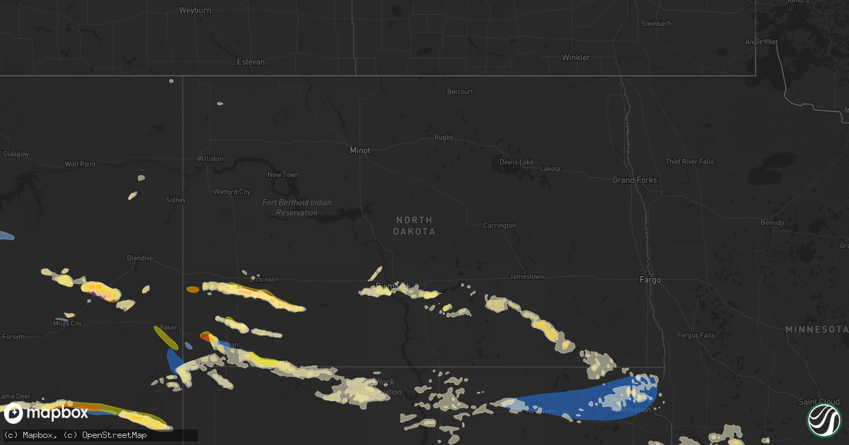
Hail Map in North Dakota on July 20, 2025
Get this storm
July 20 map
$229
one time, instant access
Download today. No call, no setup
Keep the $229
Bought the map and want the full workflow? Apply the entire $229 to a subscription within 7 days. None of it is wasted.
Every map, not just this one
This buys you this map. Subscription and you get every map we run, in the markets you choose from a few cities to whole states to nationwide. Plus real-time alerts the moment a storm fires.
Contact data
Name, contact info, occupancy, even credit band for addresses in the footprint. You go from where it hit to who to call.
Become the source they trust
Unlimited branding weather history reports on demand. You already have the documented answer ready for the property owner, and you are the one who showed up with it.
Property data and RoofTrace estimates
Pull up any address you have got, its value and the exact code rules for that jurisdiction, straight from One Click Code. Then RoofTrace estimates the squares, pitch, and roof value, priced the way you price.
Storm reports in North Dakota
North Dakota
| Date | Description |
|---|---|
| 07/20/20256:55 PM CDT | Hail for about 10 to 15 minutes. |
| 07/20/20256:30 PM CDT | Heavy rain and widespread hail covering the ground and several vehicles in ditches. Hail ranged from dime to golf ball size. |
| 07/20/20255:52 PM CDT | Hail ongoing at the time of the call. Ground is white with hail. |
| 07/20/20255:48 PM CDT | Hail lasted until 6:05 pm. Broken windows and hail covered much of the ground. |
| 07/20/20255:45 PM CDT | A local report indicates 60 MPH wind near 8 S Fryburg |
| 07/19/20259:38 PM CDT | Many vehicles hydroplaning south of bowman on hwy 85. |
| 07/19/20259:22 PM CDT | Spotter estimated winds of 60 mph and half dollar sized hail. |
| 07/19/20259:18 PM CDT | Relayed through bowman county emergency manager. Ongoing at time of call. |
| 07/19/20259:00 PM CDT | Facebook post. |
| 07/19/20258:55 PM CDT | Peak wind gust measured by private davis weather instrument. |
| 07/19/20258:00 PM CDT | Hail started around 8 pm and was ongoing at the time of the call around 815 pm. |
| 07/19/20257:42 PM CDT | Severe thunderstorm winds were accompanied by large hail. See related hail lsr for more information. |
| 07/19/20257:42 PM CDT | 60 mph winds accompanied the large hail. Wind driven large hail resulted in 3 broken windows and damage to siding. Heavy rain also occurred... 1 - 1.5 inches in 20 minu |
| 07/19/20257:15 PM CDT | Heavy rain and estimated wind gusts to 50 mph. Hail lasted for about 20 minutes. |
All States Impacted by Hail Map on July 20, 2025
Cities Impacted by Hail Map on July 20, 2025
- McDonald, KS
- Bird City, KS
- Atwood, KS
- Weskan, KS
- Sharon Springs, KS
- Stockton, KS
- Plainville, KS
- Natoma, KS
- Gray, ME
- Cumberland Center, ME
- Windham, ME
- Falmouth, ME
- Westbrook, ME
- Portland, ME
- Cumberland Foreside, ME
- Yarmouth, ME
- Chebeague Island, ME
- Wessington Springs, SD
- Alpena, SD
- Woonsocket, SD
- Artesian, SD
- Letcher, SD
- Wessington, SD
- Mitchell, SD
- Fulton, SD
- Jordan, MT
- Orlando, FL
- Christmas, FL
- Medora, ND
- White River, SD
- Cody, NE
- Kilgore, NE
- Nenzel, NE
- Belfield, ND
- Norris, SD
- South Heart, ND
- Flagler, CO
- Dickinson, ND
- New England, ND
- Valentine, NE
- Kinsey, MT
- Miles City, MT
- Ismay, MT
- Terry, MT
- Lefor, ND
- Parmelee, SD
- Gladstone, ND
- Saint Francis, SD
- Fallon, MT
- Regent, ND
- Rosebud, SD
- Joes, CO
- Cope, CO
- Bowman, ND
- Amidon, ND
- Mott, ND
- Midland, SD
- Belvidere, SD
- Kadoka, SD
- Mission, SD
- Crookston, NE
- Saint Francis, KS
- Garryowen, MT
- Lodge Grass, MT
- Golva, ND
- Sentinel Butte, ND
- Beach, ND
- Long Valley, SD
- Wood Lake, NE
- Baker, MT
- Plevna, MT
- Mandan, ND
- Rhame, ND
- Camp Crook, SD
- Thedford, NE
- Johnstown, NE
- Buffalo, SD
- Otter, MT
- Olive, MT
- Broadus, MT
- Hugo, CO
- Biddle, MT
- Reeder, ND
- Scranton, ND
- Hettinger, ND
- Moffit, ND
- Ainsworth, NE
- Boyes, MT
- Hammond, MT
- Alzada, MT
- Haswell, CO
- Eads, CO
- Center Conway, NH
- Conway, NH
- Madison, NH
- Grafton, NH
- Springfield, NH
- Danbury, NH
- Wilmot, NH
- Hill, NH
- Franklin, NH
- Sanbornton, NH
- Andover, NH
- Tilton, NH
- Belmont, NH
- Laconia, NH
- Gilford, NH
- Gilmanton, NH
- Grenville, SD
- Langford, SD
- Sisseton, SD
- Eden, SD
- Pierpont, SD
- Lake City, SD
- Peever, SD
- Roslyn, SD
- Veblen, SD
- Bath, SD
- Columbia, SD
- Andover, SD
- Ipswich, SD
- Groton, SD
- Aberdeen, SD
- Westport, SD
- Roscoe, SD
- Claremont, SD
- Britton, SD
- Amherst, SD
- Bristol, SD
- Webster, SD
- New Effington, SD
- Claire City, SD
- Wilmot, SD
- Summit, SD
- Waubay, SD
- Ortley, SD
- Beardsley, MN
- Rosholt, SD
- Browns Valley, MN
- Bismarck, ND
- Fort Pierre, SD
- Hayes, SD
- Onarga, IL
- Gilman, IL
- McIntosh, SD
- McLaughlin, SD
- Keldron, SD
- Lemmon, SD
- Morristown, SD
- Thawville, IL
- Wingate, IN
- Westpoint, IN
- Attica, IN
- Cissna Park, IL
- Milford, IL
- Eagle Butte, SD
- Virgil, SD
- Watauga, SD
- Holabird, SD
- Ree Heights, SD
- Highmore, SD
- Alexandria, SD
- Fedora, SD
- Lakewood, IL
- Shelbyville, IL
- Lewistown, MT
- Saint Lawrence, SD
- Miller, SD
- Saint Petersburg, FL
- Crescent City, IL
- Canova, SD
- Spencer, SD
- Suffield, CT
- Greenfield, IA
- Stuart, IA
- Harrold, SD
- West Union, IL
- Pana, IL
- Cowden, IL
- Oconee, IL
- Tower Hill, IL
- Standish, ME
- Gorham, ME
- Raymond, ME
- New Richmond, IN
- Crawfordsville, IN
- Sullivan, IN
- Rapid City, SD
- Stephentown, NY
- Broad Brook, CT
- Tolland, CT
- Ellington, CT
- Enfield, CT
- Molt, MT
- Broadview, MT
- Mora, NM
- Wibaux, MT
- Granby, MA
- Belchertown, MA
- Fort Stockton, TX
- Tampa, FL
- Kirk, CO
- Vona, CO
- Newton, IL
- North Yarmouth, ME
- Bloomington, IN
- Gilmanton Iron Works, NH
- Las Animas, CO
- Buckhead, GA
- Decker, MT
- Howard, SD
- Salem, SD
- Nassau, NY
- Averill Park, NY
- East Greenbush, NY
- West Sand Lake, NY
- New Salem, ND
- Cohagen, MT
- Farmersburg, IN
- Shelburn, IN
- Effingham, IL
- Lawrenceville, IL
- Bingham, IL
- Nokomis, IL
- Ramsey, IL
- Herrick, IL
- Brownstown, IL
- Vandalia, IL
- Ekalaka, MT
- Lame Deer, MT
- Busby, MT
- Gettysburg, SD
- Clewiston, FL
- Hutsonville, IL
- West York, IL
- Grenville, NM
- Vernon Rockville, CT
- Somers, CT
- Center, ND
- Yoder, CO
- Marshall, IL
- Terre Haute, IN
- Sigel, IL
- Stewardson, IL
- Shumway, IL
- Beecher City, IL
- Altamont, IL
- Farmersville, IL
- Harvel, IL
- Morrisonville, IL
- Louisville, IL
- Mason, IL
- Dieterich, IL
- Ingraham, IL
- Lambert, MT
- Fairbanks, IN
- Assumption, IL
- Florence, KY
- Erlanger, KY
- Seibert, CO
- Hidalgo, IL
- Fillmore, IL
- Melville, MT
- Birney, MT
- Ashland, MT
- Hardin, MT
- Ludlow, SD
- Stratton, CO
- Kit Carson, CO
- Bridgeport, IL
- Zolfo Springs, FL
- Wauchula, FL
- Menoken, ND
- Sterling, ND
- Driscoll, ND
- Raymond, IL
- Mansfield Center, CT
- Feeding Hills, MA
- Columbia, CT
- Andover, CT
- Coventry, CT
- Storrs Mansfield, CT
- East Windsor, CT
- West Suffield, CT
- Lodgepole, SD
- Alamo, ND
- Rosamond, IL
- Teutopolis, IL
- Madison, GA
- Tappen, ND
- Wagon Mound, NM
- Fairview, MT
- Westby, MT
- Bullhead, SD
- Reva, SD
- Boone, CO
- Karval, CO
- Ordway, CO
- Rush, CO
- Fontanelle, IA
- Ralph, SD
- Trail City, SD
- Meadow, SD
- Osgood, IN
- Moweaqua, IL
- Macon, IL
- Bassett, NE
- Burwell, NE
- Cheyenne Wells, CO
- Braddock, ND
- Mobridge, SD
- Kintyre, ND
- Gackle, ND
- Napoleon, ND
- Nebo, IL
- Streeter, ND
- Paris, MO
- Java, SD
- Bowdle, SD
- Selby, SD
- West Liberty, IL
- Willow Hill, IL
- Elsberry, MO
- Annada, MO
- Long Pine, NE
- Hoven, SD
- Witt, IL
- Mulberry Grove, IL
- Mound City, SD
- Mode, IL
- Jud, ND
- Eureka, SD
- Glenham, SD
- Herreid, SD
- Edgeley, ND
- Burlington, CO
- Akaska, SD
- Berlin, ND
- Fullerton, ND
- Dickey, ND
- Lamoure, ND
- Oakes, ND
- Cogswell, ND
- Havana, ND
- Leola, SD
- Kampsville, IL
- Forman, ND
- Rutland, ND
- Cayuga, ND
- Benson, MN
- Milbank, SD
- Labolt, SD
- Barry, MN
- Graceville, MN
- Stockholm, SD
- Stickney, SD
- Kandiyohi, MN
- Willmar, MN
- Montevideo, MN
- Appleton, MN
- Milan, MN
- Danvers, MN
- Murdock, MN
- Raymond, MN
- Clara City, MN
- Maynard, MN
- Hosmer, SD
- Madison, MN
- Dumont, MN
- Salisbury, MO
- Bellingham, MN
- Strandburg, SD
- Revillo, SD
- Watseka, IL
- Des Moines, IA
- Blue Mound, IL
- Tolstoy, SD
- Litchfield, IL
- Watson, MN
- Dawson, MN
- Kerkhoven, MN
- Denver, MO
- Martinsville, MO
- Pennock, MN
- Bethune, CO
- Arapahoe, CO
- Crow Agency, MT
- Marmarth, ND


