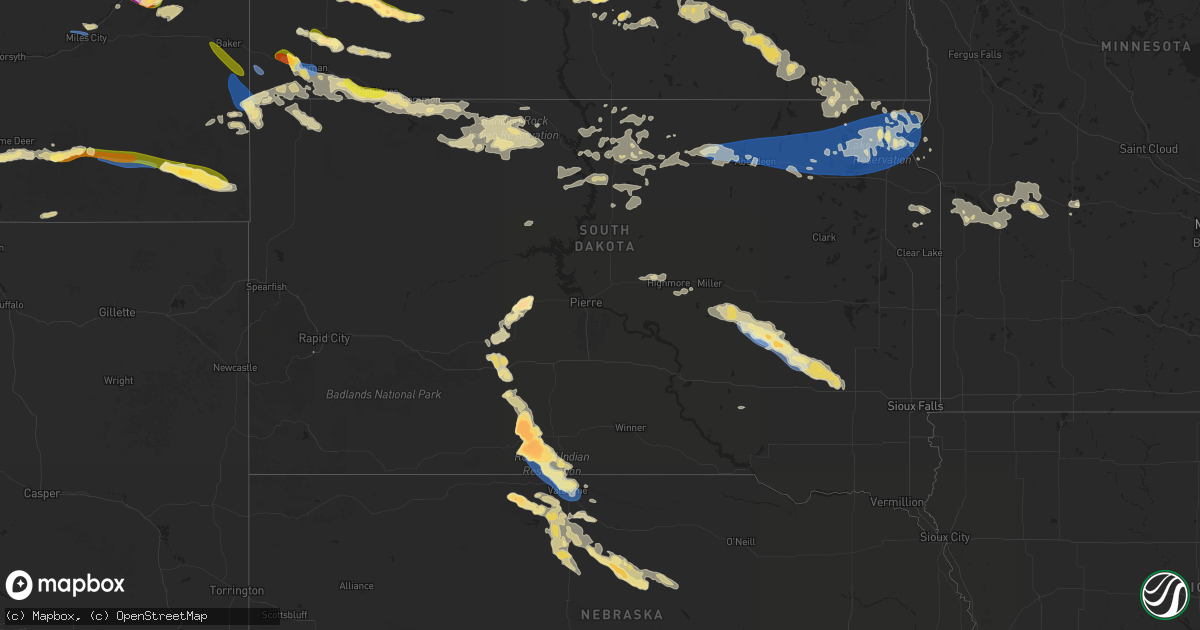
Hail Map in South Dakota on July 20, 2025
Get this storm
July 20 map
$229
one time, instant access
Download today. No call, no setup
Keep the $229
Bought the map and want the full workflow? Apply the entire $229 to a subscription within 7 days. None of it is wasted.
Every map, not just this one
This buys you this map. Subscription and you get every map we run, in the markets you choose from a few cities to whole states to nationwide. Plus real-time alerts the moment a storm fires.
Contact data
Name, contact info, occupancy, even credit band for addresses in the footprint. You go from where it hit to who to call.
Become the source they trust
Unlimited branding weather history reports on demand. You already have the documented answer ready for the property owner, and you are the one who showed up with it.
Property data and RoofTrace estimates
Pull up any address you have got, its value and the exact code rules for that jurisdiction, straight from One Click Code. Then RoofTrace estimates the squares, pitch, and roof value, priced the way you price.
Storm reports in South Dakota
South Dakota
| Date | Description |
|---|---|
| 07/20/20256:45 PM CDT | Most baseball size. |
| 07/20/20256:40 PM CDT | A local report indicates 1.00 inch wind near 2 N Parmelee |
| 07/20/20256:33 PM CDT | A local report indicates a tornado near 1 NW Parmelee |
| 07/20/20253:52 PM CDT | A trained weather spotter reported 4 inch tree branches down off a cottonwood tree. |
| 07/20/20253:36 PM CDT | Trained spotter estimated between 50-60 mph winds. Time estimated via radar. |
| 07/20/20253:33 PM CDT | Reports of a camper blown over as well as several trees blown onto powerlines. Report via social media. |
| 07/20/20253:22 PM CDT | A local report indicates 60 MPH wind near 4 NNE Letcher |
| 07/20/20253:05 PM CDT | Social media related report of numerous tree and branch damage across the town. Sides blown in on an empty grain bin. Grain truck tipped over. Partial roof damage to sh |
| 07/20/20253:05 PM CDT | A local report indicates 1.00 inch wind near Woonsocket |
| 07/20/20253:05 PM CDT | Reports of numerous tree damage across the city of woonsocket. |
| 07/20/20253:04 PM CDT | Relayed report from social media. |
| 07/20/20253:00 PM CDT | Mesonet station wsms2 woonsocket 4nnw. |
| 07/20/20252:49 PM CDT | Mesonet station 305 sd rwis lane. |
| 07/20/20252:44 PM CDT | Mesonet station 305 sd rwis lane. |
| 07/20/20252:44 PM CDT | Blown out attached garage and outbuilding. Time estimated from radar. |
| 07/20/20252:42 PM CDT | Damaged outbuilding and hoop barn. Time estimated from radar. |
| 07/20/20252:33 PM CDT | Corrects previous tstm wnd dmg report from 4 nnw lane. Reports of a camper blown over as well as several trees blown onto powerlines. Report via social media. |
| 07/20/20252:00 PM CDT | Reported via facebook. 2 inch diameter tree branches down. Time estimated from radar. |
| 07/20/20252:00 PM CDT | Mesonet station rhus2 danforth 5 e... Time estimated from radar. |
| 07/20/20254:15 AM CDT | A few tree branches down and spotter estimates 60+ mph winds. Radar estimated time. |
| 07/20/20253:45 AM CDT | Mesonet station 2 lake city |
| 07/20/20252:57 AM CDT | Personal weather station 2 miles ene aberdeen measured 62 mph peak wind gust. Exa |
| 07/20/20252:57 AM CDT | Personal weather |
| 07/20/20252:57 AM CDT | Personal weather station 2 miles ene aberdeen measured 62 |
| 07/20/20252:57 AM CDT | Personal weather station 2 miles ene aberdeen measured 62 mph peak wind gust. Exact time estimated by radar. |
| 07/20/20251:49 AM CDT | Public comment on facebook of dime to quarter sized hail along with high winds producing some light damage. Time estimated by radar. |
| 07/20/20251:49 AM CDT | Public comment on |
| 07/20/202512:40 AM CDT | Had some wheat lodged or bent over by the wind. |
| 07/19/20259:55 PM CDT | Most was smaller |
| 07/19/20258:01 PM CDT | Estimated 2.5 inch hailstone. Mostly quarter size and small. No damage reported. |
| 07/19/20257:55 PM CDT | A local report indicates 1.25 inch wind near 7 N Belvidere |
| 07/19/20257:50 PM CDT | A local report indicates 1.75 inch wind near 7 ESE Saint Francis |
| 07/19/20257:45 PM CDT | (u |
| 07/19/20257:45 PM CDT | A local report indicates 70 MPH wind near 8 SSE Tuthill |
| 07/19/20257:45 PM CDT | Updated location. 8 sse of tuthill was the incorrect location. |
| 07/19/20257:43 PM CDT | Most quarter size. Been hailing for 15 minutes and still hailing. |
| 07/19/20257:15 PM CDT | A local report indicates 4.50 inch wind near Rosebud |
| 07/19/20257:14 PM CDT | A local report indicates 2.75 inch wind near Rosebud |
| 07/19/20257:04 PM CDT | A local report indicates 2.50 inch wind near 5 NW Saint Francis |
All States Impacted by Hail Map on July 20, 2025
Cities Impacted by Hail Map on July 20, 2025
- McDonald, KS
- Bird City, KS
- Atwood, KS
- Weskan, KS
- Sharon Springs, KS
- Stockton, KS
- Plainville, KS
- Natoma, KS
- Gray, ME
- Cumberland Center, ME
- Windham, ME
- Falmouth, ME
- Westbrook, ME
- Portland, ME
- Cumberland Foreside, ME
- Yarmouth, ME
- Chebeague Island, ME
- Wessington Springs, SD
- Alpena, SD
- Woonsocket, SD
- Artesian, SD
- Letcher, SD
- Wessington, SD
- Mitchell, SD
- Fulton, SD
- Jordan, MT
- Orlando, FL
- Christmas, FL
- Medora, ND
- White River, SD
- Cody, NE
- Kilgore, NE
- Nenzel, NE
- Belfield, ND
- Norris, SD
- South Heart, ND
- Flagler, CO
- Dickinson, ND
- New England, ND
- Valentine, NE
- Kinsey, MT
- Miles City, MT
- Ismay, MT
- Terry, MT
- Lefor, ND
- Parmelee, SD
- Gladstone, ND
- Saint Francis, SD
- Fallon, MT
- Regent, ND
- Rosebud, SD
- Joes, CO
- Cope, CO
- Bowman, ND
- Amidon, ND
- Mott, ND
- Midland, SD
- Belvidere, SD
- Kadoka, SD
- Mission, SD
- Crookston, NE
- Saint Francis, KS
- Garryowen, MT
- Lodge Grass, MT
- Golva, ND
- Sentinel Butte, ND
- Beach, ND
- Long Valley, SD
- Wood Lake, NE
- Baker, MT
- Plevna, MT
- Mandan, ND
- Rhame, ND
- Camp Crook, SD
- Thedford, NE
- Johnstown, NE
- Buffalo, SD
- Otter, MT
- Olive, MT
- Broadus, MT
- Hugo, CO
- Biddle, MT
- Reeder, ND
- Scranton, ND
- Hettinger, ND
- Moffit, ND
- Ainsworth, NE
- Boyes, MT
- Hammond, MT
- Alzada, MT
- Haswell, CO
- Eads, CO
- Center Conway, NH
- Conway, NH
- Madison, NH
- Grafton, NH
- Springfield, NH
- Danbury, NH
- Wilmot, NH
- Hill, NH
- Franklin, NH
- Sanbornton, NH
- Andover, NH
- Tilton, NH
- Belmont, NH
- Laconia, NH
- Gilford, NH
- Gilmanton, NH
- Grenville, SD
- Langford, SD
- Sisseton, SD
- Eden, SD
- Pierpont, SD
- Lake City, SD
- Peever, SD
- Roslyn, SD
- Veblen, SD
- Bath, SD
- Columbia, SD
- Andover, SD
- Ipswich, SD
- Groton, SD
- Aberdeen, SD
- Westport, SD
- Roscoe, SD
- Claremont, SD
- Britton, SD
- Amherst, SD
- Bristol, SD
- Webster, SD
- New Effington, SD
- Claire City, SD
- Wilmot, SD
- Summit, SD
- Waubay, SD
- Ortley, SD
- Beardsley, MN
- Rosholt, SD
- Browns Valley, MN
- Bismarck, ND
- Fort Pierre, SD
- Hayes, SD
- Onarga, IL
- Gilman, IL
- McIntosh, SD
- McLaughlin, SD
- Keldron, SD
- Lemmon, SD
- Morristown, SD
- Thawville, IL
- Wingate, IN
- Westpoint, IN
- Attica, IN
- Cissna Park, IL
- Milford, IL
- Eagle Butte, SD
- Virgil, SD
- Watauga, SD
- Holabird, SD
- Ree Heights, SD
- Highmore, SD
- Alexandria, SD
- Fedora, SD
- Lakewood, IL
- Shelbyville, IL
- Lewistown, MT
- Saint Lawrence, SD
- Miller, SD
- Saint Petersburg, FL
- Crescent City, IL
- Canova, SD
- Spencer, SD
- Suffield, CT
- Greenfield, IA
- Stuart, IA
- Harrold, SD
- West Union, IL
- Pana, IL
- Cowden, IL
- Oconee, IL
- Tower Hill, IL
- Standish, ME
- Gorham, ME
- Raymond, ME
- New Richmond, IN
- Crawfordsville, IN
- Sullivan, IN
- Rapid City, SD
- Stephentown, NY
- Broad Brook, CT
- Tolland, CT
- Ellington, CT
- Enfield, CT
- Molt, MT
- Broadview, MT
- Mora, NM
- Wibaux, MT
- Granby, MA
- Belchertown, MA
- Fort Stockton, TX
- Tampa, FL
- Kirk, CO
- Vona, CO
- Newton, IL
- North Yarmouth, ME
- Bloomington, IN
- Gilmanton Iron Works, NH
- Las Animas, CO
- Buckhead, GA
- Decker, MT
- Howard, SD
- Salem, SD
- Nassau, NY
- Averill Park, NY
- East Greenbush, NY
- West Sand Lake, NY
- New Salem, ND
- Cohagen, MT
- Farmersburg, IN
- Shelburn, IN
- Effingham, IL
- Lawrenceville, IL
- Bingham, IL
- Nokomis, IL
- Ramsey, IL
- Herrick, IL
- Brownstown, IL
- Vandalia, IL
- Ekalaka, MT
- Lame Deer, MT
- Busby, MT
- Gettysburg, SD
- Clewiston, FL
- Hutsonville, IL
- West York, IL
- Grenville, NM
- Vernon Rockville, CT
- Somers, CT
- Center, ND
- Yoder, CO
- Marshall, IL
- Terre Haute, IN
- Sigel, IL
- Stewardson, IL
- Shumway, IL
- Beecher City, IL
- Altamont, IL
- Farmersville, IL
- Harvel, IL
- Morrisonville, IL
- Louisville, IL
- Mason, IL
- Dieterich, IL
- Ingraham, IL
- Lambert, MT
- Fairbanks, IN
- Assumption, IL
- Florence, KY
- Erlanger, KY
- Seibert, CO
- Hidalgo, IL
- Fillmore, IL
- Melville, MT
- Birney, MT
- Ashland, MT
- Hardin, MT
- Ludlow, SD
- Stratton, CO
- Kit Carson, CO
- Bridgeport, IL
- Zolfo Springs, FL
- Wauchula, FL
- Menoken, ND
- Sterling, ND
- Driscoll, ND
- Raymond, IL
- Mansfield Center, CT
- Feeding Hills, MA
- Columbia, CT
- Andover, CT
- Coventry, CT
- Storrs Mansfield, CT
- East Windsor, CT
- West Suffield, CT
- Lodgepole, SD
- Alamo, ND
- Rosamond, IL
- Teutopolis, IL
- Madison, GA
- Tappen, ND
- Wagon Mound, NM
- Fairview, MT
- Westby, MT
- Bullhead, SD
- Reva, SD
- Boone, CO
- Karval, CO
- Ordway, CO
- Rush, CO
- Fontanelle, IA
- Ralph, SD
- Trail City, SD
- Meadow, SD
- Osgood, IN
- Moweaqua, IL
- Macon, IL
- Bassett, NE
- Burwell, NE
- Cheyenne Wells, CO
- Braddock, ND
- Mobridge, SD
- Kintyre, ND
- Gackle, ND
- Napoleon, ND
- Nebo, IL
- Streeter, ND
- Paris, MO
- Java, SD
- Bowdle, SD
- Selby, SD
- West Liberty, IL
- Willow Hill, IL
- Elsberry, MO
- Annada, MO
- Long Pine, NE
- Hoven, SD
- Witt, IL
- Mulberry Grove, IL
- Mound City, SD
- Mode, IL
- Jud, ND
- Eureka, SD
- Glenham, SD
- Herreid, SD
- Edgeley, ND
- Burlington, CO
- Akaska, SD
- Berlin, ND
- Fullerton, ND
- Dickey, ND
- Lamoure, ND
- Oakes, ND
- Cogswell, ND
- Havana, ND
- Leola, SD
- Kampsville, IL
- Forman, ND
- Rutland, ND
- Cayuga, ND
- Benson, MN
- Milbank, SD
- Labolt, SD
- Barry, MN
- Graceville, MN
- Stockholm, SD
- Stickney, SD
- Kandiyohi, MN
- Willmar, MN
- Montevideo, MN
- Appleton, MN
- Milan, MN
- Danvers, MN
- Murdock, MN
- Raymond, MN
- Clara City, MN
- Maynard, MN
- Hosmer, SD
- Madison, MN
- Dumont, MN
- Salisbury, MO
- Bellingham, MN
- Strandburg, SD
- Revillo, SD
- Watseka, IL
- Des Moines, IA
- Blue Mound, IL
- Tolstoy, SD
- Litchfield, IL
- Watson, MN
- Dawson, MN
- Kerkhoven, MN
- Denver, MO
- Martinsville, MO
- Pennock, MN
- Bethune, CO
- Arapahoe, CO
- Crow Agency, MT
- Marmarth, ND


