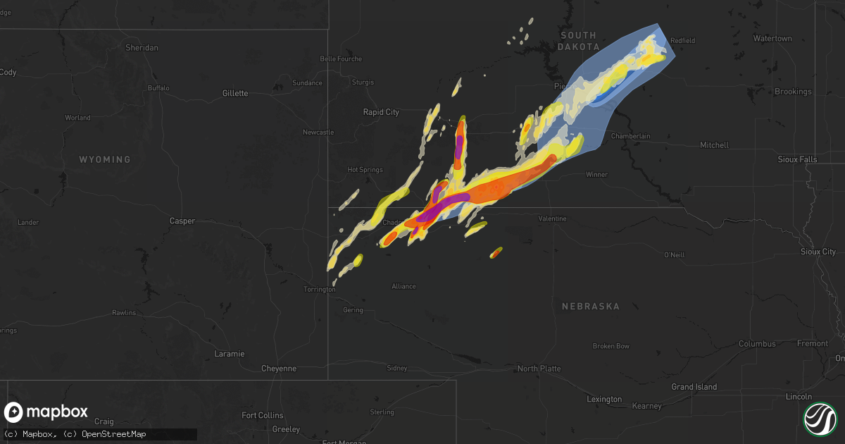
Hail Map on June 28, 2026
Get this storm
June 28 map
$229
one time, instant access
Download today. No call, no setup
Keep the $229
Bought the map and want the full workflow? Apply the entire $229 to a subscription within 7 days. None of it is wasted.
Every map, not just this one
This buys you this map. Subscription and you get every map we run, in the markets you choose from a few cities to whole states to nationwide. Plus real-time alerts the moment a storm fires.
Contact data
Name, contact info, occupancy, even credit band for addresses in the footprint. You go from where it hit to who to call.
Become the source they trust
Unlimited branding weather history reports on demand. You already have the documented answer ready for the property owner, and you are the one who showed up with it.
Property data and RoofTrace estimates
Pull up any address you have got, its value and the exact code rules for that jurisdiction, straight from One Click Code. Then RoofTrace estimates the squares, pitch, and roof value, priced the way you price.
States Impacted by Hail Map on June 28, 2026
Storm reports
South Dakota
| Date | Description |
|---|---|
| 06/28/20266:58 AM CDT | Mesonet station 158 miranda |
| 06/28/20266:49 AM CDT | Ambient weather station. |
| 06/28/20266:45 AM CDT | Hand county emergency manager reports widespread damage over northern to northwestern hand county. Damage includes power lines and trees down... Buildings down... And c |
| 06/28/20266:45 AM CDT | Ambient weather station. |
| 06/28/20266:45 AM CDT | Weather underground station. |
| 06/28/20266:45 AM CDT | Weather underground station. |
| 06/28/20266:44 AM CDT | Mesonet station 312 ree heights |
| 06/28/20266:42 AM CDT | Em reported a garage was lost and other damage to outbuildings. Time/location estimated. |
| 06/28/20266:39 AM CDT | Peak wind gust thus far on ambient weather station. |
| 06/28/20266:34 AM CDT | Mesonet station 312 ree heights |
| 06/28/20266:30 AM CDT | Power lines down in ree heights. Time estimated via radar and other reports. |
| 06/28/20266:25 AM CDT | Mesonet station hihs2 highmore |
| 06/28/20266:20 AM CDT | Peak wind gust at a weather underground station. |
| 06/28/20266:20 AM CDT | Mesonet station hihs2 highmore |
| 06/28/20266:20 AM CDT | Pictures show widespread damage across highmore... Including trees uprooted and snapped... Damage to buildings and dented grain bin... Knocked over farm items and trail |
| 06/28/20266:19 AM CDT | Peak wind gust on ambient weather station. |
| 06/28/20266:17 AM CDT | Emergency manager reports winds of 70 to 80 mph with small hail. |
| 06/28/20266:15 AM CDT | 131 mph peak wind on an ambient weather station. |
| 06/28/20265:56 AM CDT | Siding torn off house and barn door blow off. Time estimated from radar. |
| 06/28/20265:55 AM CDT | Mesonet station prfs2 pierre 16 ese |
| 06/28/20265:49 AM CDT | Mesonet station 333 de grey hill |
| 06/28/20265:48 AM CDT | 111.8 mph peak wind gust on ambient wx station. |
| 06/28/20265:20 AM CDT | Mesonet station vvms2 vivian 12s |
| 06/28/20265:13 AM CDT | Mesonet station 13 vivian |
| 06/28/20264:43 AM CDT | Report via facebook. |
| 06/28/20264:27 AM CDT | Some tree branches down. |
| 06/28/20264:26 AM CDT | A local report indicates 1.00 inch wind near 3 SSE White River |
| 06/28/20264:00 AM CDT | Hail has dented vehicles. Largest hail was 1.5 inches. |
| 06/28/20263:54 AM CDT | A local report indicates 83 MPH wind near 11 SW Parmelee |
| 06/28/20263:54 AM CDT | A local report indicates 77 MPH wind near 6 W Parmelee |
| 06/28/20263:50 AM CDT | A local report indicates 83 MPH wind near 3 NNE Harrington |
| 06/28/20263:45 AM CDT | A local report indicates 60 MPH wind near 3 NNE Harrington |
| 06/28/20263:36 AM CDT | Time estimated based on radar. |
| 06/28/20263:15 AM CDT | A local report indicates 81 MPH wind near 4 ENE Martin |
| 06/28/20263:10 AM CDT | A local report indicates 66 MPH wind near 4 ENE Martin |
| 06/28/20262:34 AM CDT | Time estimated based on radar. |
| 06/28/20262:33 AM CDT | Photo of estimated half dollar size hail received via social media from batesland along the northern edge of the main storm core. Time estimated based on report and rad |
| 06/28/20262:29 AM CDT | Reported in the wakpamani area. Time estimated based on radar. |
| 06/28/20262:19 AM CDT | Estimated near the intersection of us-18 and highway 391. Time estimated based on radar. |
| 06/27/202611:35 PM CDT | A local report indicates 2.00 inch wind near Interior |
North Dakota
| Date | Description |
|---|---|
| 06/28/20262:30 AM CDT | Nddot site measured a 62 mph wind gust 6.4 miles west of churchs ferry... Nd. |
| 06/28/20262:15 AM CDT | Delayed report: siding damage to multiple homes in leeds and vehicle damage from hail. |
| 06/28/20261:30 AM CDT | Delayed report. |
| 06/28/202612:35 AM CDT | Ping pong ball size hail. |
| 06/28/202612:30 AM CDT | Time estimated by radar. |
| 06/27/202610:02 PM CDT | Wind gusts of 60 to 70 mph accompanied by 0.5 inch diameter hail. |
| 06/27/20269:55 PM CDT | 61 mph wind gust at 10m measured at the turtle lake 4n ndawn. |
| 06/27/20269:00 PM CDT | Multiple photos received of a tornado. Time and location estimated based on radar. |
| 06/27/20268:54 PM CDT | 1 inch |
| 06/27/20268:42 PM CDT | Trained spotter reports hail up to the size of half dollars. Also reported gusty wind and approximately 0.35 inches of rain. |
| 06/27/20267:42 PM CDT | Spotter reports 1.5 inch hail north of new salem. Sizes range from dime up to ping pong sized. No rain or wind. |
Florida
| Date | Description |
|---|---|
| 06/28/20264:14 PM CDT | Two mobile homes in north fort myers had roof damage. A video of lofted circulating debris supports a very brief touchdown... Lifting about two-thirds of a roof off of |
Wisconsin
| Date | Description |
|---|---|
| 06/28/20264:05 AM CDT | Report from mping: half dollar |
South Carolina
| Date | Description |
|---|---|
| 06/28/20263:21 PM CDT | Tree down on king st. |
| 06/28/20263:08 PM CDT | Corrects previous tstm wnd dmg report and time estimated from radar for 1 ne springdale. Tree down on king circle. |
| 06/28/20263:08 PM CDT | Lancaster county sheriffs office reports numerous trees down in and around the city of lancaster... Sc. Time estimated from radar. |
| 06/28/20263:08 PM CDT | Power outages reported due to downed trees along and north of saluda rd. |
| 06/28/20262:55 PM CDT | Power outages reported due to downed trees. |
| 06/28/20262:02 PM CDT | Power lines down in the 100 block of monarch hwy. |
| 06/28/20262:02 PM CDT | Tree down on a car and boat on lockhart hwy near frank hill loop. |
| 06/28/20261:52 PM CDT | Tree down across high plains dr. |
| 06/28/20261:52 PM CDT | Tree down near the intersection of pinegate dr and sonoco road. |
| 06/28/20261:21 PM CDT | Social media picture of a tree down across ethel road. |
Iowa
| Date | Description |
|---|---|
| 06/28/20262:08 PM CDT | Several 1-2 inch size hailstones. |
| 06/28/20261:33 PM CDT | A local report indicates 59 MPH wind near Monmouth |
| 06/28/202612:30 PM CDT | Gas station awning collapse. This awning was previously damaged from a storm some time ago. Other nearby trees and sheds not damaged. |
| 06/28/20268:17 AM CDT | Pws gust. |
| 06/28/20268:08 AM CDT | Delayed pws gust. |
| 06/28/20267:14 AM CDT | A local report indicates 1.50 inch wind near Webb |
North Carolina
| Date | Description |
|---|---|
| 06/28/20266:08 PM CDT | Tree down across doc road. |
| 06/28/20265:08 PM CDT | Corrects time of event previous tstm wnd dmg report from 3 w monroeton. Tree down across doc road. |
| 06/28/20264:30 PM CDT | Time estimated on radar. |
New Mexico
| Date | Description |
|---|---|
| 06/27/20267:38 PM CDT | A local report indicates 61 MPH wind near 5 W Whites City |
Texas
| Date | Description |
|---|---|
| 06/28/20265:44 PM CDT | A local report indicates 75 MPH wind near 3 NNW Belding |
Nebraska
| Date | Description |
|---|---|
| 06/28/20262:48 AM CDT | Report via social media with pictures. Time estimated from radar. |
| 06/28/20262:10 AM CDT | Delayed report via social media with pictures. Time estimated from radar. |
| 06/28/20262:06 AM CDT | Report with photo via social media. Time estimated from radar. |
| 06/28/20262:06 AM CDT | Report via social media with pictures. Time estimated from radar. |
| 06/28/20261:48 AM CDT | Corrects previous hail report from 10 nw rushville. Report via social media with pictures. Time estimated from radar. |
| 06/28/20261:25 AM CDT | Quarter sized hail. Exact time estimated based on radar. |
| 06/28/20261:15 AM CDT | Estimated timing based on radar. |
| 06/28/20261:12 AM CDT | Several pictures on social media reported ping pong ball sized hail at chadron state park. Picture shows possible larger stones. |
| 06/27/202611:50 PM CDT | Report with photo via social media. Time estimated from radar. |
| 06/27/202611:45 PM CDT | Delayed report via social media with pictures. Time estimated from radar. |
| 06/27/20269:52 PM CDT | A local report indicates 1.00 inch wind near 11 S Merriman |
Maine
| Date | Description |
|---|---|
| 06/28/20265:03 PM CDT | Corrects previous non-tstm wnd gst report from 1 wnw augusta. Asos station kaug augusta reported a wind gust of 52kts. |
| 06/28/20264:51 PM CDT | Medium to large tree down in front from apartment complex. Also reported smaller trees down and uprooted nearby. |
| 06/28/20264:36 PM CDT | Public facebook post showing hailstones ranging from roughly dime size to quarter size. Time estimated by radar. |
Cities Impacted by Hail Map on June 28, 2026
- Sioux Rapids, IA
- Webb, IA
- Marathon, IA
- Rembrandt, IA
- Linn Grove, IA
- Spencer, IA
- Greenville, IA
- Dickens, IA
- Gillett Grove, IA
- Ruthven, IA
- Emmetsburg, IA
- Graettinger, IA
- Laurens, IA
- Albert City, IA
- Armstrong, IA
- Ringsted, IA
- Ayrshire, IA
- Curlew, IA
- Mallard, IA
- Cylinder, IA
- Bancroft, IA
- Lakota, IA
- Lone Rock, IA
- Fenton, IA
- Swea City, IA
- Whittemore, IA
- Titonka, IA
- Burt, IA
- Rolfe, IA
- Havelock, IA
- West Bend, IA
- Plover, IA
- Algona, IA
- Bode, IA
- Wesley, IA
- Lu Verne, IA
- Pocahontas, IA
- Ottosen, IA
- Hardy, IA
- Livermore, IA
- Renwick, IA
- Humboldt, IA
- Bradgate, IA
- Rutland, IA
- Corwith, IA
- Britt, IA
- Woden, IA
- Garner, IA
- Kanawha, IA
- Forest City, IA
- Goodell, IA
- Ventura, IA
- Klemme, IA
- Thornton, IA
- Otho, IA
- Duncombe, IA
- Lehigh, IA
- Callender, IA
- Fort Dodge, IA
- Belmond, IA
- Clear Lake, IA
- Jefferson, IA
- Boone, IA
- Ames, IA
- Gilbert, IA
- Story City, IA
- Roland, IA
- Radcliffe, IA
- Nevada, IA
- McCallsburg, IA
- Hubbard, IA
- Zearing, IA
- New Providence, IA
- Saint Anthony, IA
- Clemons, IA
- Union, IA
- Marshalltown, IA
- Hudson, IA
- Waterloo, IA
- Hazleton, IA
- La Porte City, IA
- Aurora, IA
- Stanley, IA
- Independence, IA
- Winthrop, IA
- Masonville, IA
- Manchester, IA
- Ryan, IA
- Hopkinton, IA
- Delhi, IA
- Central City, IA
- Anamosa, IA
- Monticello, IA
- Worthington, IA
- Langworthy, IA
- Center Junction, IA
- Oxford Junction, IA
- Wyoming, IA
- Onslow, IA
- Baldwin, IA
- Lost Nation, IA
- Monmouth, IA
- Maquoketa, IA
- Grand Mound, IA
- Delmar, IA
- Charlotte, IA
- De Witt, IA
- Goose Lake, IA
- Bryant, IA
- Clinton, IA
- McConnells, SC
- Chester, SC
- Sharon, SC
- Rock Hill, SC
- Richburg, SC
- Edgemoor, SC
- Fort Lawn, SC
- Catawba, SC
- Lancaster, SC
- Preston, IA
- Spragueville, IA
- Bellevue, IA
- Lamesa, TX
- Plymouth, NC
- Roper, NC
- Mount Vernon, ME
- Kents Hill, ME
- Bolton, NC
- Odonnell, TX
- Orlando, FL
- Columbus, ND
- Noonan, ND
- Portal, ND
- La Grange, NC
- Fort Stockton, TX
- Powers Lake, ND
- Coyanosa, TX
- Grandfalls, TX
- Flasher, ND
- Solen, ND
- New Salem, ND
- Almont, ND
- Cody, NE
- Whitman, NE
- Beulah, ND
- Stanton, ND
- Andrews, TX
- Hazen, ND
- Halliday, ND
- Golden Valley, ND
- Washburn, ND
- Zap, ND
- Seminole, TX
- Underwood, ND
- Riverdale, ND
- Coleharbor, ND
- Loop, TX
- Seagraves, TX
- Harborside, ME
- Garrison, ND
- Douglas, ND
- Ryder, ND
- Des Lacs, ND
- Merriman, NE
- Turtle Lake, ND
- Benedict, ND
- Minot, ND
- Burlington, ND
- Ruso, ND
- Minot Afb, ND
- Max, ND
- Butte, ND
- Lansford, ND
- Glenburn, ND
- Voltaire, ND
- Martin, SD
- Balfour, ND
- Allen, SD
- Gordon, NE
- Porcupine, SD
- Wanblee, SD
- Drake, ND
- Anamoose, ND
- Martin, ND
- Karlsruhe, ND
- Hay Springs, NE
- Rushville, NE
- Willow City, ND
- Harvey, ND
- Batesland, SD
- Interior, SD
- Sawyer, ND
- Rugby, ND
- Chadron, NE
- Rolette, ND
- Maddock, ND
- Kyle, SD
- Velva, ND
- Berthold, ND
- Wall, SD
- Kadoka, SD
- Harrison, NE
- Quinn, SD
- Philip, SD
- Granville, ND
- Mylo, ND
- Marsland, NE
- Scenic, SD
- Towner, ND
- Minnewaukan, ND
- Milesville, SD
- New Underwood, SD
- Balta, ND
- Esmond, ND
- Crawford, NE
- Owanka, SD
- Whitney, NE
- Pine Ridge, SD
- Wounded Knee, SD
- York, ND
- Wasta, SD
- Leeds, ND
- Hillman, MN
- Knox, ND
- Manderson, SD
- Caputa, SD
- Churchs Ferry, ND
- Cando, ND
- Oelrichs, SD
- Starkweather, ND
- Penn, ND
- Florence, WI
- Webster, ND
- Dupree, SD
- Tuthill, SD
- Brule, WI
- Devils Lake, ND
- Edgemont, SD
- Eagle Butte, SD
- Lake Nebagamon, WI
- Solon Springs, WI
- Maida, ND
- Hampden, ND
- Norris, SD
- Long Valley, SD
- Parmelee, SD
- White River, SD
- Edmore, ND
- Lawton, ND
- Okaton, SD
- Saint Francis, SD
- Perronville, MI
- Pembine, WI
- Fairdale, ND
- Fish Creek, WI
- Sister Bay, WI
- Ephraim, WI
- Baileys Harbor, WI
- Amberg, WI
- Daggett, MI
- Vulcan, MI
- Milton, ND
- Mission, SD
- Wood, SD
- Murdo, SD
- Draper, SD
- Mountain, ND
- Edinburg, ND
- Crystal, ND
- Cavalier, ND
- Hoople, ND
- Fort Pierre, SD
- Ideal, SD
- Winner, SD
- Presho, SD
- Vivian, SD
- Adams, ND
- Saint Thomas, ND
- Hensel, ND
- Hamilton, ND
- Kennebec, SD
- Pierre, SD
- Blunt, SD
- Lower Brule, SD
- Escanaba, MI
- Harrold, SD
- Hamill, SD
- Reliance, SD
- Onida, SD
- Hallock, MN
- Drayton, ND
- Saint Vincent, MN
- Lancaster, MN
- Garden, MI
- Holabird, SD
- Highmore, SD
- Stephan, SD
- Fort Thompson, SD
- Miller, SD
- Ree Heights, SD
- Saint Lawrence, SD
- Lebanon, SD
- Orient, SD
- Seneca, SD
- Tolstoy, SD
- Badger, MN
- Tulare, SD
- Wessington, SD
- Redfield, SD
- Rockham, SD
- Hitchcock, SD
- Faulkton, SD
- Cresbard, SD
- Frankfort, SD
- Ashton, SD
- Turton, SD
- Doland, SD