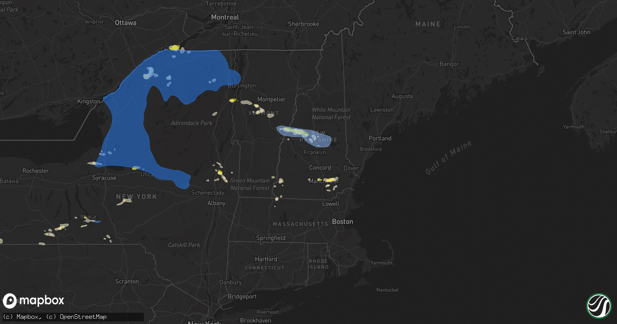
Hail Map in Vermont on July 20, 2021
Get this storm
July 20 map
$229
one time, instant access
Download today. No call, no setup
Keep the $229
Bought the map and want the full workflow? Apply the entire $229 to a subscription within 7 days. None of it is wasted.
Every map, not just this one
This buys you this map. Subscription and you get every map we run, in the markets you choose from a few cities to whole states to nationwide. Plus real-time alerts the moment a storm fires.
Contact data
Name, contact info, occupancy, even credit band for addresses in the footprint. You go from where it hit to who to call.
Become the source they trust
Unlimited branding weather history reports on demand. You already have the documented answer ready for the property owner, and you are the one who showed up with it.
Property data and RoofTrace estimates
Pull up any address you have got, its value and the exact code rules for that jurisdiction, straight from One Click Code. Then RoofTrace estimates the squares, pitch, and roof value, priced the way you price.
Storm reports in Vermont
Vermont
| Date | Description |
|---|---|
| 07/20/20216:58 PM CDT | Trees and powerlines down on multiple roads. |
| 07/20/20216:50 PM CDT | Trees on road and powerlines. Time estimated. |
| 07/20/20216:34 PM CDT | Several trees and powerlines down. |
| 07/20/20216:30 PM CDT | Trees and wires down on poker hill rd. |
| 07/20/20216:06 PM CDT | Large oak tree down. Also a tree down on river rd. |
| 07/20/20216:04 PM CDT | Trees down. |
| 07/20/20216:02 PM CDT | Tree down on i-89 between exit 12 and 13. |
| 07/20/20215:59 PM CDT | Tree down on car on marble and st. Paul st. |
| 07/20/20215:59 PM CDT | Tree down across hardscrabble road. |
| 07/20/20215:58 PM CDT | Tree down on power lines on west shore rd. |
| 07/20/20215:14 AM CDT | At 1014 PM EDT, severe thunderstorms were located along a line extending from near Newport to near Westmoreland, moving east at 35 mph. HAZARD...60 mph wind gusts and quarter size hail. SOURCE...Radar indicated. IMPACT...Hail damage to vehicles is expected. Expect wind damage to roofs, siding, and trees. Locations impacted include... Keene, Henniker, Charlestown, Antrim, Hancock, Bradford, Harrisville, Nelson, Newport, Gilsum, Windsor, Walpole, Warner, Hillsborough, Alstead, Westmoreland, Marlow, Roxbury, Sullivan and Surry.This includes Interstate 89 between mile markers 16 and 29. This also includes... Mount Sunapee. |
| 07/20/20214:24 AM CDT | At 924 PM EDT, severe thunderstorms were located along a line extending from near Lebanon to 8 miles northwest of Claremont, moving east at 50 mph. HAZARD...60 mph wind gusts and quarter size hail. SOURCE...Radar indicated. IMPACT...Hail damage to vehicles is expected. Expect wind damage to roofs, siding, and trees. Locations impacted include... Lebanon, Grafton, Hanover, Enfield, Canaan, Danbury, Groton, Grantham, Cornish, Croydon, Hebron, Plainfield, Orange, Springfield and Wilmot.This includes Interstate 89 between mile markers 39 and 60. |
| 07/20/20213:58 AM CDT | At 858 PM EDT, severe thunderstorms were located along a line extending from 8 miles southwest of Piermont to 10 miles north of Lebanon to near Hanover, moving northeast at 30 mph. HAZARD...60 mph wind gusts and penny size hail. SOURCE...Radar indicated. IMPACT...Expect damage to roofs, siding, and trees. Locations impacted include... Lebanon, Hanover, Haverhill, Canaan, Groton, Piermont, Woodstock, Lyme, Benton, Dorchester, Easton, Ellsworth, Wentworth, Orford, Rumney and Orange.This also includes... Mount Moosilauke, Rumney Rocks, Carr Mountain, and Long PondRecreation Area. |
| 07/20/20213:54 AM CDT | At 853 PM EDT, a severe thunderstorm was located near Mechanicville, moving east at 35 mph. HAZARD...60 mph wind gusts. SOURCE...Radar indicated. IMPACT...Expect damage to roofs, siding, and trees. Locations impacted include... Mechanicville, Hoosick Falls, Cambridge, Greenwich, Gates, Hoosick, Lee, White Creek, Easton, Stillwater, Schuylerville, Victory, Schaghticoke, Valley Falls, Deans Corners, Schaghticoke Hill, Center White Creek, Hoosick Junction, Center Falls and Petersburg Junction. |
| 07/20/20213:31 AM CDT | At 831 PM EDT, severe thunderstorms were located along a line extending from near Lake George Village to near Corinth to near Galway, moving east at 25 mph. HAZARD...60 mph wind gusts. SOURCE...Radar indicated. IMPACT...Expect damage to roofs, siding, and trees. Locations impacted include... Saratoga Springs, Glens Falls, Hudson Falls, Salem, Lake George Village, Ballston Spa, Fort Edward, Corinth, Granville, Hartford, Greenwich, Round Lake, Galway, Comstock, Rock City Falls, Glens Falls North, North Ballston Spa, West Glens Falls, Lake Luzerne-Hadley and Kings. |
| 07/19/20219:27 PM CDT | Trees and wires down. Time estimated by radar. |
| 07/19/20218:30 PM CDT | Trees down on main street. |
| 07/19/20218:15 PM CDT | Tree down on route 153. Time estimated by radar. |
| 07/19/20218:07 PM CDT | 2 poplar trees down on powerlines. |
| 07/19/20218:02 PM CDT | Many trees uprooted in a straight line through the new boston road area. |
| 07/19/20218:02 PM CDT | Trees down. |
| 07/19/20218:00 PM CDT | Trees down. |
All States Impacted by Hail Map on July 20, 2021
Cities Impacted by Hail Map on July 20, 2021
- Payson, AZ
- Painted Post, NY
- Beaver Dams, NY
- Rome, NY
- Verona, NY
- Woodhull, NY
- Troupsburg, NY
- Knoxville, PA
- Niagara Falls, NY
- Youngstown, NY
- Ransomville, NY
- Niagara University, NY
- Lewiston, NY
- Roxbury, VT
- Derry, NH
- Londonderry, NH
- Mission, TX
- Chester, NH
- Raymond, NH
- Auburn, NH
- Candia, NH
- Madrid, NY
- Canton, NY
- Mexico, NY
- Granville, VT
- Roseglen, ND
- Garrison, ND
- Minden City, MI
- Harbor Beach, MI
- Ruth, MI
- Olean, NY
- Callery, PA
- Evans City, PA
- Zelienople, PA
- Mars, PA
- Cranberry Township, PA
- New Town, ND
- Keene, ND
- Watford City, ND
- Utica, PA
- Stoneboro, PA
- Greenville, PA
- Clarks Mills, PA
- Carlton, PA
- Sandy Lake, PA
- Hadley, PA
- Fredonia, PA
- Saint Regis Falls, NY
- Potsdam, NY
- Parishville, NY
- Constable, NY
- Watkins Glen, NY
- Campbell, NY
- Corning, NY
- North Hudson, NY
- Goffstown, NH
- Schuylerville, NY
- Saratoga Springs, NY
- Gansevoort, NY
- Encino, TX
- Harlingen, TX
- Weirton, WV
- Colliers, WV
- Sanborn, NY
- Lockport, NY
- Brookfield, VT
- East Randolph, VT
- Randolph Center, VT
- Randolph, VT
- Kinde, MI
- Filion, MI
- Westmoreland, NH
- Keene, NH
- Edinburg, TX
- Marana, AZ
- Lebanon, NH
- Enfield, NH
- Eloy, AZ
- Essex, NY
- Westport, NY
- Titusville, PA
- Oil City, PA
- Pleasantville, PA
- Newfield, NY
- Spencer, NY
- Ithaca, NY
- Brooktondale, NY
- Windham, NH
- Johnsonville, NY
- Cambridge, NY
- Schaghticoke, NY
- Greenwich, NY
- Valley Falls, NY
- Buffalo, NY
- Zolfo Springs, FL
- Campbell, OH
- Vienna, OH
- Hubbard, OH
- Girard, OH
- Youngstown, OH
- Niles, OH
- Delevan, NY
- Tijeras, NM
- Fort McCoy, FL
- Northfield, MA
- Altmar, NY
- Fulton, NY
- Pennellville, NY
- Phoenix, NY
- Hooksett, NH
- Manchester, NH
- Grace, ID
- Allegany, NY
- Limestone, NY
- Rensselaer Falls, NY
- Hogansburg, NY
- Centerville, PA
- Rumney, NH
- Santa Fe, NM
- Warren, VT
- Port Hope, MI
- Bancroft, ID
- Waitsfield, VT
- Cameron Mills, NY
- Bristol, VT
- Bunnell, FL
- Hebron, NH
- Hampstead, NH
- Sandown, NH
- New Hampton, NH
- Bristol, NH
- Westfield, PA
- Osceola, PA
- Cedar Crest, NM
- Parish, NY
- Central Square, NY
- North Branch, MI
- Fort Edward, NY
- Queensbury, NY
- Kingsville, TX
- East Thetford, VT
- Thetford Center, VT
- Lyme, NH
- Fort Covington, NY
- Fort Sumner, NM
- Prescott, AZ
- Haines City, FL
- Warren, PA
- Tucson, AZ
- Plymouth, NY
- South Otselic, NY
- Norwich, VT
- Hanover, NH
- South Strafford, VT
- Kittanning, PA
- Templeton, PA
- Espanola, NM
- Santa Cruz, NM
- Addison, NY
- Roberts, MT
- Marcy, NY
- Sherburne, NY
- Pitcher, NY
- North Pitcher, NY
- Smyrna, NY
- Spartansburg, PA
- Transfer, PA
- Show Low, AZ
- Oxford, MI
- Metamora, MI
- Russell, PA
- Canaan, NH
- Sharon, VT
- Brasher Falls, NY
- Moira, NY
- Bombay, NY
- Lisbon, NY
- Fowler, OH
- Hydetown, PA
- Rouseville, PA
- Van Etten, NY
- Cayuta, NY
- Middleport, NY
- Chelsea, MI
- Corinth, NY
- Hannibal, NY
- Brewerton, NY
- Salem, NY
- West Chesterfield, NH
- Chesterfield, NH
- Putney, VT
- Franklin, PA
- Starksboro, VT
- Vergennes, VT
- New Haven, VT
- North Ferrisburgh, VT
- Ferrisburgh, VT
- Owego, NY
- Endicott, NY
- Akron, NY
- Gasport, NY
- Getzville, NY
- Tonawanda, NY
- Clarence Center, NY
- East Amherst, NY
- North Tonawanda, NY
- Pontiac, MI
- Auburn Hills, MI
- Lake Orion, MI
- Newfane, NY
- Burt, NY
- Sanbornton, NH
- South Colton, NY
- Edgewater, FL
- Stillwater, NY
- Waterford, MI
- Bloomfield Hills, MI
- Keego Harbor, MI
- West Bloomfield, MI
- Appleton, NY
- Schuyler Falls, NY
- Sullivan City, TX
- La Joya, TX
- Cameron, NY
- Westons Mills, NY
- Center Harbor, NH
- Eldred, PA
- Bradford, PA
- Derrick City, PA
- Portville, NY
- Vernon, VT
- Winchester, NH
- Hinsdale, NH
- Au Sable Forks, NY
- Francestown, NH
- New Boston, NH
- Weare, NH
- Attica, MI
- Dryden, MI
- Lapeer, MI
- Plymouth, NH
- Ashland, NH
- Brown City, MI
- Clarence, NY
- Renfrew, PA
- Butler, PA
- Valencia, PA
- Walpole, NH
- Oracle, AZ
- Rimersburg, PA
- Ballston Spa, NY
- Vestal, NY
- Alpine, WY
- Etna, WY
- Forestville, MI
- Palms, MI
- Astor, FL
- Alpine, NY
- Burdett, NY
- Odessa, NY
- Dayton, PA
- New Bethlehem, PA
- Binghamton, NY
- Irvine, PA
- Youngsville, PA
- Millers Falls, MA
- Erving, MA
- Ortonville, MI
- Wibaux, MT
- Golva, ND
- Baker, MT
- Manchester, MI
- Mirror Lake, NH
- Holderness, NH
- Hill, NH
- Strafford, VT
- Meredith, NH
- South Royalton, VT
- Belmont, NH
- Gilford, NH
- Etna, NH
- Alton Bay, NH
- Moultonborough, NH
- Laconia, NH
- Chase Mills, NY
- Palatine Bridge, NY
- Fort Drum, NY
- Rainbow Lake, NY
- Keeseville, NY
- Greig, NY
- Mooers Forks, NY
- Mallory, NY
- Waddington, NY
- Watertown, NY
- Pulaski, NY
- Westernville, NY
- Malone, NY
- Sprakers, NY
- Castorland, NY
- Hammond, NY
- Cold Brook, NY
- Jay, NY
- Rodman, NY
- Dexter, NY
- Peru, NY
- Edwards, NY
- Ellenburg Depot, NY
- Nicholville, NY
- Russell, NY
- Caroga Lake, NY
- Lacona, NY
- Turin, NY
- Massena, NY
- Colton, NY
- De Peyster, NY
- Childwold, NY
- Brushton, NY
- Saranac, NY
- West Chazy, NY
- Canajoharie, NY
- Saranac Lake, NY
- West Monroe, NY
- Utica, NY
- Forestport, NY
- Chaumont, NY
- Hastings, NY
- Dolgeville, NY
- Cranberry Lake, NY
- West Leyden, NY
- Heuvelton, NY
- Frankfort, NY
- Fultonville, NY
- North Lawrence, NY
- Baldwinsville, NY
- De Kalb Junction, NY
- Brownville, NY
- Saint Johnsville, NY
- Remsen, NY
- Theresa, NY
- Newport, NY
- West Stockholm, NY
- Poland, NY
- Black River, NY
- Sandy Creek, NY
- Fonda, NY
- Port Leyden, NY
- Herkimer, NY
- Norwood, NY
- Redwood, NY
- Oriskany, NY
- Grand Isle, VT
- Blossvale, NY
- Camden, NY
- Ellenburg Center, NY
- Adams Center, NY
- Bloomingdale, NY
- Chateaugay, NY
- Gloversville, NY
- Philadelphia, NY
- Clayton, NY
- Norfolk, NY
- Mooers, NY
- Carthage, NY
- Paul Smiths, NY
- Clay, NY
- Calcium, NY
- Middleville, NY
- Harrisville, NY
- Wellesley Island, NY
- Brier Hill, NY
- Churubusco, NY
- Little Falls, NY
- Wilmington, NY
- Cadyville, NY
- Salisbury Center, NY
- Barneveld, NY
- Constantia, NY
- Colchester, VT
- Lake Clear, NY
- Brantingham, NY
- La Fargeville, NY
- Cleveland, NY
- North Bangor, NY
- Boonville, NY
- Alexandria Bay, NY
- Redford, NY
- Prospect, NY
- Owls Head, NY
- Gouverneur, NY
- Glenfield, NY
- Lee Center, NY
- Antwerp, NY
- Hermon, NY
- Fort Plain, NY
- Westdale, NY
- Williamstown, NY
- Tupper Lake, NY
- Lowville, NY
- Stratford, NY
- Ava, NY
- Nelliston, NY
- Vermontville, NY
- Lyon Mountain, NY
- Alder Creek, NY
- Evans Mills, NY
- Mohawk, NY
- Morrisonville, NY
- Thousand Island Park, NY
- Burlington, VT
- Mannsville, NY
- Durhamville, NY
- Ogdensburg, NY
- Croghan, NY
- Lorraine, NY
- North Bay, NY
- Richville, NY
- Constableville, NY
- Natural Bridge, NY
- Helena, NY
- Taberg, NY
- Richland, NY
- Felts Mills, NY
- Adams, NY
- Lyons Falls, NY
- Winthrop, NY
- Woodgate, NY
- Johnstown, NY
- Plessis, NY
- Stittville, NY
- Bernhards Bay, NY
- Redfield, NY
- Dickinson Center, NY
- South Hero, VT
- Copenhagen, NY
- Altona, NY
- Plattsburgh, NY
- Holland Patent, NY
- Burke, NY
- Berkshire, NY
- Richford, NY
- Bad Axe, MI
- Beach, ND
- Choteau, MT


