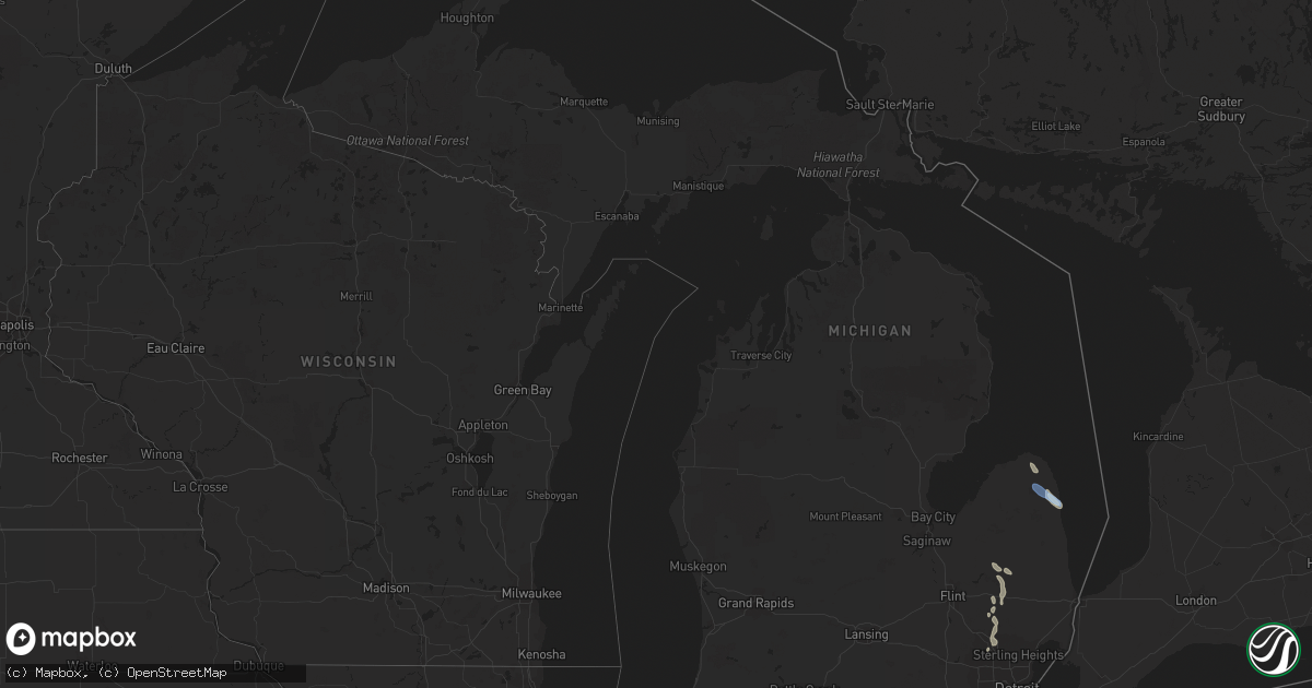
Hail Map in Michigan on July 20, 2021
Get this storm
July 20 map
$229
one time, instant access
Download today. No call, no setup
Keep the $229
Bought the map and want the full workflow? Apply the entire $229 to a subscription within 7 days. None of it is wasted.
Every map, not just this one
This buys you this map. Subscription and you get every map we run, in the markets you choose from a few cities to whole states to nationwide. Plus real-time alerts the moment a storm fires.
Contact data
Name, contact info, occupancy, even credit band for addresses in the footprint. You go from where it hit to who to call.
Become the source they trust
Unlimited branding weather history reports on demand. You already have the documented answer ready for the property owner, and you are the one who showed up with it.
Property data and RoofTrace estimates
Pull up any address you have got, its value and the exact code rules for that jurisdiction, straight from One Click Code. Then RoofTrace estimates the squares, pitch, and roof value, priced the way you price.
Storm reports in Michigan
Michigan
| Date | Description |
|---|---|
| 07/20/20215:50 PM CDT | Trees reported down in auburn hills... As well as several other cities in oakland county. |
| 07/20/20215:23 PM CDT | A trained spotter estimated 60 mph winds and reported pea size hail. |
| 07/20/20214:40 PM CDT | Trees and wires reported down... Most numerous in attica township. |
| 07/20/20212:23 PM CDT | Tree limbs and power lines reported down... Mostly in sigel township. |
| 07/20/20213:06 AM CDT | At 806 PM EDT, severe thunderstorms were located along a line extending from near Chelsea to near Dexter to near Canton, moving southeast at 25 mph. HAZARD...60 mph wind gusts. SOURCE...Radar indicated. IMPACT...Expect damage to roofs, siding, and trees. Severe thunderstorms will be near... Salem around 810 PM EDT. Ypsilanti around 815 PM EDT. Ann Arbor and Dixboro around 820 PM EDT.Other locations in the path of these severe thunderstorms includeSaline, Manchester, Willis and Milan. |
| 07/20/20212:28 AM CDT | At 727 PM EDT, severe thunderstorms were located along a line extending from near South Lyon to near West Bloomfield to near Detroit Zoo, moving south at 30 mph. HAZARD...60 mph wind gusts. SOURCE...Radar indicated. IMPACT...Expect damage to roofs, siding, and trees. Severe thunderstorms will be near... Livonia around 735 PM EDT. Detroit around 740 PM EDT. Dearborn around 745 PM EDT. Downtown Detroit, Canton and Belle Isle around 750 PM EDT. Romulus, Wyandotte and Greenfield Village around 800 PM EDT. Taylor around 805 PM EDT. Trenton and Belleville around 820 PM EDT. Flat Rock and Grosse Ile around 825 PM EDT.Other locations impacted by these severe thunderstorms includeFranklin, Melvindale, Gibraltar, New Boston, Rockwood, FarmingtonHills, Harper Woods, Westland, Grosse Pointe Shores and Ecorse. |
| 07/20/20211:43 AM CDT | At 642 PM EDT, severe thunderstorms were located along a line extending from near Clarkston to Rochester to near Macomb Township, moving south at 20 mph. HAZARD...60 mph wind gusts. SOURCE...Radar indicated. IMPACT...Expect damage to roofs, siding, and trees. Severe thunderstorms will be near... Rochester around 645 PM EDT. Macomb Township around 650 PM EDT. Troy, Sterling Heights and Clinton around 655 PM EDT. Mount Clemens around 700 PM EDT. Royal Oak around 710 PM EDT. Warren, St. Clair Shores and Birmingham around 715 PM EDT. Detroit Zoo around 720 PM EDT. Southfield around 725 PM EDT.Other locations impacted by these severe thunderstorms includeRoseville, Shelby Township, Utica, Lathrup Village, Auburn Hills,Bingham Farms, Lake Angelus, Pleasant Ridge, Center Line andHuntington Woods. |
| 07/20/202112:59 AM CDT | At 559 PM EDT, a severe thunderstorm was located over Almont, moving southeast at 25 mph. HAZARD...60 mph wind gusts and quarter size hail. SOURCE...Radar indicated. IMPACT...Hail damage to vehicles is expected. Expect wind damage to roofs, siding, and trees. Locations impacted include... Romeo, Armada and New Baltimore. |
| 07/19/202111:57 PM CDT | At 456 PM EDT, a severe thunderstorm was located over North Branch, moving southeast at 30 mph. HAZARD...60 mph wind gusts and quarter size hail. SOURCE...Radar indicated. IMPACT...Hail damage to vehicles is expected. Expect wind damage to roofs, siding, and trees. This severe thunderstorm will be near... Lum around 510 PM EDT.Other locations in the path of this severe thunderstorm include ImlayCity, Dryden and Almont. |
| 07/19/20219:57 PM CDT | At 256 PM EDT, severe thunderstorms were located along a line extending from near Port Hope to near Kinde to Pigeon, moving southeast at 25 mph. HAZARD...60 mph wind gusts and quarter size hail. SOURCE...Radar indicated. IMPACT...Hail damage to vehicles is expected. Expect wind damage to roofs, siding, and trees. Severe thunderstorms will be near... Port Hope around 305 PM EDT. Harbor Beach around 315 PM EDT.Other locations in the path of these severe thunderstorms include BadAxe, Ubly and Forestville. |
| 07/19/20217:15 PM CDT | Large tree limb reported down. |
| 07/19/20217:00 PM CDT | Multiple trees and large tree limbs reported down. |
All States Impacted by Hail Map on July 20, 2021
Cities Impacted by Hail Map on July 20, 2021
- Payson, AZ
- Painted Post, NY
- Beaver Dams, NY
- Rome, NY
- Verona, NY
- Woodhull, NY
- Troupsburg, NY
- Knoxville, PA
- Niagara Falls, NY
- Youngstown, NY
- Ransomville, NY
- Niagara University, NY
- Lewiston, NY
- Roxbury, VT
- Derry, NH
- Londonderry, NH
- Mission, TX
- Chester, NH
- Raymond, NH
- Auburn, NH
- Candia, NH
- Madrid, NY
- Canton, NY
- Mexico, NY
- Granville, VT
- Roseglen, ND
- Garrison, ND
- Minden City, MI
- Harbor Beach, MI
- Ruth, MI
- Olean, NY
- Callery, PA
- Evans City, PA
- Zelienople, PA
- Mars, PA
- Cranberry Township, PA
- New Town, ND
- Keene, ND
- Watford City, ND
- Utica, PA
- Stoneboro, PA
- Greenville, PA
- Clarks Mills, PA
- Carlton, PA
- Sandy Lake, PA
- Hadley, PA
- Fredonia, PA
- Saint Regis Falls, NY
- Potsdam, NY
- Parishville, NY
- Constable, NY
- Watkins Glen, NY
- Campbell, NY
- Corning, NY
- North Hudson, NY
- Goffstown, NH
- Schuylerville, NY
- Saratoga Springs, NY
- Gansevoort, NY
- Encino, TX
- Harlingen, TX
- Weirton, WV
- Colliers, WV
- Sanborn, NY
- Lockport, NY
- Brookfield, VT
- East Randolph, VT
- Randolph Center, VT
- Randolph, VT
- Kinde, MI
- Filion, MI
- Westmoreland, NH
- Keene, NH
- Edinburg, TX
- Marana, AZ
- Lebanon, NH
- Enfield, NH
- Eloy, AZ
- Essex, NY
- Westport, NY
- Titusville, PA
- Oil City, PA
- Pleasantville, PA
- Newfield, NY
- Spencer, NY
- Ithaca, NY
- Brooktondale, NY
- Windham, NH
- Johnsonville, NY
- Cambridge, NY
- Schaghticoke, NY
- Greenwich, NY
- Valley Falls, NY
- Buffalo, NY
- Zolfo Springs, FL
- Campbell, OH
- Vienna, OH
- Hubbard, OH
- Girard, OH
- Youngstown, OH
- Niles, OH
- Delevan, NY
- Tijeras, NM
- Fort McCoy, FL
- Northfield, MA
- Altmar, NY
- Fulton, NY
- Pennellville, NY
- Phoenix, NY
- Hooksett, NH
- Manchester, NH
- Grace, ID
- Allegany, NY
- Limestone, NY
- Rensselaer Falls, NY
- Hogansburg, NY
- Centerville, PA
- Rumney, NH
- Santa Fe, NM
- Warren, VT
- Port Hope, MI
- Bancroft, ID
- Waitsfield, VT
- Cameron Mills, NY
- Bristol, VT
- Bunnell, FL
- Hebron, NH
- Hampstead, NH
- Sandown, NH
- New Hampton, NH
- Bristol, NH
- Westfield, PA
- Osceola, PA
- Cedar Crest, NM
- Parish, NY
- Central Square, NY
- North Branch, MI
- Fort Edward, NY
- Queensbury, NY
- Kingsville, TX
- East Thetford, VT
- Thetford Center, VT
- Lyme, NH
- Fort Covington, NY
- Fort Sumner, NM
- Prescott, AZ
- Haines City, FL
- Warren, PA
- Tucson, AZ
- Plymouth, NY
- South Otselic, NY
- Norwich, VT
- Hanover, NH
- South Strafford, VT
- Kittanning, PA
- Templeton, PA
- Espanola, NM
- Santa Cruz, NM
- Addison, NY
- Roberts, MT
- Marcy, NY
- Sherburne, NY
- Pitcher, NY
- North Pitcher, NY
- Smyrna, NY
- Spartansburg, PA
- Transfer, PA
- Show Low, AZ
- Oxford, MI
- Metamora, MI
- Russell, PA
- Canaan, NH
- Sharon, VT
- Brasher Falls, NY
- Moira, NY
- Bombay, NY
- Lisbon, NY
- Fowler, OH
- Hydetown, PA
- Rouseville, PA
- Van Etten, NY
- Cayuta, NY
- Middleport, NY
- Chelsea, MI
- Corinth, NY
- Hannibal, NY
- Brewerton, NY
- Salem, NY
- West Chesterfield, NH
- Chesterfield, NH
- Putney, VT
- Franklin, PA
- Starksboro, VT
- Vergennes, VT
- New Haven, VT
- North Ferrisburgh, VT
- Ferrisburgh, VT
- Owego, NY
- Endicott, NY
- Akron, NY
- Gasport, NY
- Getzville, NY
- Tonawanda, NY
- Clarence Center, NY
- East Amherst, NY
- North Tonawanda, NY
- Pontiac, MI
- Auburn Hills, MI
- Lake Orion, MI
- Newfane, NY
- Burt, NY
- Sanbornton, NH
- South Colton, NY
- Edgewater, FL
- Stillwater, NY
- Waterford, MI
- Bloomfield Hills, MI
- Keego Harbor, MI
- West Bloomfield, MI
- Appleton, NY
- Schuyler Falls, NY
- Sullivan City, TX
- La Joya, TX
- Cameron, NY
- Westons Mills, NY
- Center Harbor, NH
- Eldred, PA
- Bradford, PA
- Derrick City, PA
- Portville, NY
- Vernon, VT
- Winchester, NH
- Hinsdale, NH
- Au Sable Forks, NY
- Francestown, NH
- New Boston, NH
- Weare, NH
- Attica, MI
- Dryden, MI
- Lapeer, MI
- Plymouth, NH
- Ashland, NH
- Brown City, MI
- Clarence, NY
- Renfrew, PA
- Butler, PA
- Valencia, PA
- Walpole, NH
- Oracle, AZ
- Rimersburg, PA
- Ballston Spa, NY
- Vestal, NY
- Alpine, WY
- Etna, WY
- Forestville, MI
- Palms, MI
- Astor, FL
- Alpine, NY
- Burdett, NY
- Odessa, NY
- Dayton, PA
- New Bethlehem, PA
- Binghamton, NY
- Irvine, PA
- Youngsville, PA
- Millers Falls, MA
- Erving, MA
- Ortonville, MI
- Wibaux, MT
- Golva, ND
- Baker, MT
- Manchester, MI
- Mirror Lake, NH
- Holderness, NH
- Hill, NH
- Strafford, VT
- Meredith, NH
- South Royalton, VT
- Belmont, NH
- Gilford, NH
- Etna, NH
- Alton Bay, NH
- Moultonborough, NH
- Laconia, NH
- Chase Mills, NY
- Palatine Bridge, NY
- Fort Drum, NY
- Rainbow Lake, NY
- Keeseville, NY
- Greig, NY
- Mooers Forks, NY
- Mallory, NY
- Waddington, NY
- Watertown, NY
- Pulaski, NY
- Westernville, NY
- Malone, NY
- Sprakers, NY
- Castorland, NY
- Hammond, NY
- Cold Brook, NY
- Jay, NY
- Rodman, NY
- Dexter, NY
- Peru, NY
- Edwards, NY
- Ellenburg Depot, NY
- Nicholville, NY
- Russell, NY
- Caroga Lake, NY
- Lacona, NY
- Turin, NY
- Massena, NY
- Colton, NY
- De Peyster, NY
- Childwold, NY
- Brushton, NY
- Saranac, NY
- West Chazy, NY
- Canajoharie, NY
- Saranac Lake, NY
- West Monroe, NY
- Utica, NY
- Forestport, NY
- Chaumont, NY
- Hastings, NY
- Dolgeville, NY
- Cranberry Lake, NY
- West Leyden, NY
- Heuvelton, NY
- Frankfort, NY
- Fultonville, NY
- North Lawrence, NY
- Baldwinsville, NY
- De Kalb Junction, NY
- Brownville, NY
- Saint Johnsville, NY
- Remsen, NY
- Theresa, NY
- Newport, NY
- West Stockholm, NY
- Poland, NY
- Black River, NY
- Sandy Creek, NY
- Fonda, NY
- Port Leyden, NY
- Herkimer, NY
- Norwood, NY
- Redwood, NY
- Oriskany, NY
- Grand Isle, VT
- Blossvale, NY
- Camden, NY
- Ellenburg Center, NY
- Adams Center, NY
- Bloomingdale, NY
- Chateaugay, NY
- Gloversville, NY
- Philadelphia, NY
- Clayton, NY
- Norfolk, NY
- Mooers, NY
- Carthage, NY
- Paul Smiths, NY
- Clay, NY
- Calcium, NY
- Middleville, NY
- Harrisville, NY
- Wellesley Island, NY
- Brier Hill, NY
- Churubusco, NY
- Little Falls, NY
- Wilmington, NY
- Cadyville, NY
- Salisbury Center, NY
- Barneveld, NY
- Constantia, NY
- Colchester, VT
- Lake Clear, NY
- Brantingham, NY
- La Fargeville, NY
- Cleveland, NY
- North Bangor, NY
- Boonville, NY
- Alexandria Bay, NY
- Redford, NY
- Prospect, NY
- Owls Head, NY
- Gouverneur, NY
- Glenfield, NY
- Lee Center, NY
- Antwerp, NY
- Hermon, NY
- Fort Plain, NY
- Westdale, NY
- Williamstown, NY
- Tupper Lake, NY
- Lowville, NY
- Stratford, NY
- Ava, NY
- Nelliston, NY
- Vermontville, NY
- Lyon Mountain, NY
- Alder Creek, NY
- Evans Mills, NY
- Mohawk, NY
- Morrisonville, NY
- Thousand Island Park, NY
- Burlington, VT
- Mannsville, NY
- Durhamville, NY
- Ogdensburg, NY
- Croghan, NY
- Lorraine, NY
- North Bay, NY
- Richville, NY
- Constableville, NY
- Natural Bridge, NY
- Helena, NY
- Taberg, NY
- Richland, NY
- Felts Mills, NY
- Adams, NY
- Lyons Falls, NY
- Winthrop, NY
- Woodgate, NY
- Johnstown, NY
- Plessis, NY
- Stittville, NY
- Bernhards Bay, NY
- Redfield, NY
- Dickinson Center, NY
- South Hero, VT
- Copenhagen, NY
- Altona, NY
- Plattsburgh, NY
- Holland Patent, NY
- Burke, NY
- Berkshire, NY
- Richford, NY
- Bad Axe, MI
- Beach, ND
- Choteau, MT


