Hail Map in New Hampshire on July 20, 2021
Get this storm
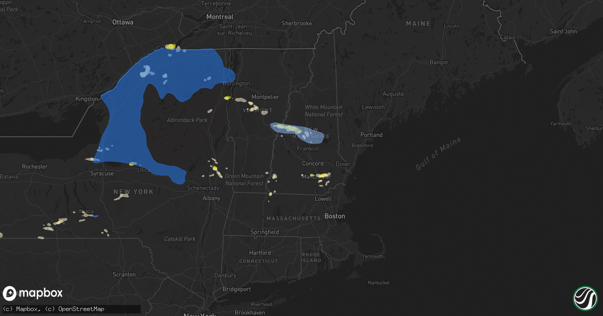
July 20 map
$229
one time, instant access
Download today. No call, no setup
Keep the $229
Bought the map and want the full workflow? Apply the entire $229 to a subscription within 7 days. None of it is wasted.
Every map, not just this one
This buys you this map. Subscription and you get every map we run, in the markets you choose from a few cities to whole states to nationwide. Plus real-time alerts the moment a storm fires.
Contact data
Name, contact info, occupancy, even credit band for addresses in the footprint. You go from where it hit to who to call.
Become the source they trust
Unlimited branding weather history reports on demand. You already have the documented answer ready for the property owner, and you are the one who showed up with it.
Property data and RoofTrace estimates
Pull up any address you have got, its value and the exact code rules for that jurisdiction, straight from One Click Code. Then RoofTrace estimates the squares, pitch, and roof value, priced the way you price.
Storm reports in New Hampshire
New Hampshire
| Date | Description |
|---|---|
| 07/20/20216:28 AM CDT | At 1128 PM EDT, a severe thunderstorm was located near Goffstown, or near Manchester, moving east at 40 mph. HAZARD...60 mph wind gusts and quarter size hail. SOURCE...Radar indicated. IMPACT...Hail damage to vehicles is expected. Expect wind damage to roofs, siding, and trees. Locations impacted include... Manchester, Derry, Exeter, Northwood, Bedford, Hooksett, Amherst, Epping, Brentwood, Raymond, Goffstown, Newmarket, Londonderry, Bow, Kingston, Chester, Danville, Lee, Allenstown and Fremont.This includes the following highways... Interstate 293 between mile markers 1 and 11. Interstate 93 between mile markers 17 and 31. |
| 07/20/20216:08 AM CDT | At 1108 PM EDT, severe thunderstorms were located along a line extending from near Effingham to 7 miles southeast of Ossipee to 8 miles north of Farmington, moving east at 25 mph. HAZARD...60 mph wind gusts and penny size hail. SOURCE...Radar indicated. IMPACT...Expect damage to roofs, siding, and trees. Locations impacted include... Alfred, Buxton, Hollis, Hiram, Cornish, Waterboro, Standish, Lyman, Limington, Limerick, Acton, Parsonsfield, Newfield, Shapleigh, Porter, Dayton and Baldwin. |
| 07/20/20215:10 AM CDT | At 1010 PM EDT, severe thunderstorms were located along a line extending from 10 miles southwest of Woodstock to Plymouth to 9 miles south of Ashland to near Franklin, moving east at 25 mph. HAZARD...60 mph wind gusts and quarter size hail. SOURCE...Radar indicated. IMPACT...Hail damage to vehicles is expected. Expect wind damage to roofs, siding, and trees. Locations impacted include... Laconia, Meredith, Moultonborough, Plymouth, Alton, Gilmanton, Holderness, Ashland, Woodstock, Sandwich, Tamworth, Belmont, Gilford, Center Harber, Ellsworth, Campton, Sanbornton, Thornton, Waterville Valley and New Hampton.This includes Interstate 93 between mile markers 59 and 68, betweenmile markers 74 and 75, and between mile markers 79 and 96. This also includes... Lake Winnipesaukee, Squam Lake, Mount Tecumseh, Welch Mountain, andDickey Mountain. |
| 07/20/20215:00 AM CDT | At 1000 PM EDT, severe thunderstorms were located along a line extending from near Chester to near Monroe, moving east at 25 mph. HAZARD...60 mph wind gusts. SOURCE...Radar indicated. IMPACT...Expect damage to roofs, siding, and trees. Locations impacted include... Brattleboro, Bellows Falls, Townshend, Putney, Vernon, Wilmington, Readsboro, Saxtons River, Westminster, Newfane, Guilford Center, Rockingham, Guilford, Whitingham, Dover, Marlboro, Wardsboro, Halifax, Grafton and Brookline. |
| 07/20/20214:35 AM CDT | At 935 PM EDT, severe thunderstorms were located along a line extending from 8 miles southeast of Piermont to near Groton to 6 miles south of Enfield, moving east at 30 mph. HAZARD...60 mph wind gusts and quarter size hail. SOURCE...Radar indicated. IMPACT...Hail damage to vehicles is expected. Expect wind damage to roofs, siding, and trees. Locations impacted include... Franklin, Plymouth, Meredith, Moultonborough, Grafton, Enfield, Canaan, Holderness, Ashland, Danbury, Groton, Woodstock, Piermont, Sandwich, Bristol, Grantham, Center Harber, Hill, Croydon and Hebron.This includes the following highways... Interstate 89 between mile markers 41 and 47. Interstate 93 between mile markers 66 and 96.This also includes... Rumney Rocks, Squam Lake, Carr Mountain, Stinson Mountain, andMount Tecumseh. |
| 07/20/20213:54 AM CDT | At 852 PM EDT, a line of severe thunderstorms over south central Vermont was located along a line extending from near South Strafford to West Bridgewater to near North Pawlet, moving southeast at 30 mph. HAZARD...60 mph wind gusts and quarter size hail. SOURCE...Radar indicated. IMPACT...Expect wind damage to trees and powerlines. Minor hail damage to vehicles is possible. Locations impacted include... Woodstock, Chester, Hartland Four Corners, Cavendish, Ludlow Village, Perkinsville Village, Wallingford, Mt. Holly, Mt. Tabor, Rutland - Southern Vermont Airport, Pomfret, Plymouth, Hartland, Wells, Barnard, Windsor, Woodstock Village, Pawlet, Mount Holly and Ludlow. |
| 07/20/20213:33 AM CDT | At 831 PM EDT, a severe thunderstorm was located near Chelsea, Vermont moving east at 35 mph. HAZARD...60 mph wind gusts and quarter size hail. SOURCE...Radar indicated. IMPACT...Expect wind damage to trees and powerlines as this storm has a history of wind damage. Minor hail damage to vehicles is possible along with very heavy rainfall. Locations impacted include... Bradford, Thetford Hill State Park, Chelsea, Corinth, Randolph, Strafford, Thetford, Fairlee, West Fairlee, Tunbridge, Vershire, Corinth Corners, Washington, Thetford Center, Newbury Village, Williamstown, Brookfield, Braintree Hill, Newbury and Braintree. |
| 07/20/20212:32 AM CDT | At 730 PM EDT, a line of severe thunderstorms over western Vermont was located along a line extending from near East Franklin to Stowe to East Warren to Mossy Point, moving east at 40 mph. HAZARD...60 mph wind gusts and quarter size hail. SOURCE...Radar indicated. IMPACT...Expect wind damage to trees and powerlines. Minor hail damage to vehicles is possible. This line of storms has a history of producing wind damage and power outages. Locations impacted include... Barre, Montpelier, Island Pond, Lyndon, St. Johnsbury, Middlebury, Newport City, Vergennes, Crown Point, Morrisville, Enosburg Falls, Orleans, Derby Center, Charleston, Braintree Hill, Glover, Waterbury Village, Montgomery Center, Websterville and Orwell. |
| 07/19/202111:32 PM CDT | Report from mping: 1-inch tree limbs broken; shingles blown off. |
| 07/19/202111:20 PM CDT | Trees down... Power outages. |
| 07/19/202110:45 PM CDT | Ping pong sized hail began around 11:45pm and lasted for less than 3 minutes. Tree limbs down. |
| 07/19/202110:30 PM CDT | A local report indicates 1.25 inch wind near 1 W GOFFSTOWN |
| 07/19/202110:30 PM CDT | Multiple reports of trees and wires down in manchester. |
| 07/19/202110:28 PM CDT | A local report indicates 1.00 inch wind near FITZWILLIAM |
| 07/19/202110:05 PM CDT | Corrects previous tstm wnd dmg report from 1 se peterborough. Several trees down around intersection of 202 and 101. |
| 07/19/202110:05 PM CDT | Trees and power lines down. |
| 07/19/202110:00 PM CDT | Two trees down on us hwy 202 partially blocking traffic between hillsborough and antrim... Nh. |
| 07/19/20219:50 PM CDT | Trees and power lines down. |
| 07/19/20219:50 PM CDT | A local report indicates 1.25 inch wind near 2 E HINSDALE |
| 07/19/20219:45 PM CDT | Large tree limbs to 12 inches in diameter down across town of meredith. |
| 07/19/20219:45 PM CDT | Trees down all across the town of gilford. |
| 07/19/20219:45 PM CDT | Trees and power lines down. |
| 07/19/20219:30 PM CDT | Hail on north side of keene fell for 5 minutes. |
| 07/19/20219:20 PM CDT | Several trees down around intersection of 202 and 101. |
| 07/19/20219:15 PM CDT | Trees and wires down. |
| 07/19/20219:10 PM CDT | Trees down all across town. Unconfirmed power outages via social media. Time estimated by radar. |
| 07/19/20219:10 PM CDT | A local report indicates 65 MPH wind near BRISTOL |
| 07/19/20219:10 PM CDT | Quarter size hail for 3 to 5 minutes with largest stones to 1.25 inches. |
| 07/19/20219:00 PM CDT | A local report indicates 1.00 inch wind near 2 NW HEBRON |
| 07/19/20218:35 PM CDT | Trees down. |
| 07/19/20218:33 PM CDT | Corrects previous tstm wnd dmg report from orange. Trees down. |
| 07/19/20218:15 PM CDT | Many trees down in town. Time estimated. |
| 07/19/20218:10 PM CDT | Time estimated. |
All States Impacted by Hail Map on July 20, 2021
Cities Impacted by Hail Map on July 20, 2021
- Payson, AZ
- Painted Post, NY
- Beaver Dams, NY
- Rome, NY
- Verona, NY
- Woodhull, NY
- Troupsburg, NY
- Knoxville, PA
- Niagara Falls, NY
- Youngstown, NY
- Ransomville, NY
- Niagara University, NY
- Lewiston, NY
- Roxbury, VT
- Derry, NH
- Londonderry, NH
- Mission, TX
- Chester, NH
- Raymond, NH
- Auburn, NH
- Candia, NH
- Madrid, NY
- Canton, NY
- Mexico, NY
- Granville, VT
- Roseglen, ND
- Garrison, ND
- Minden City, MI
- Harbor Beach, MI
- Ruth, MI
- Olean, NY
- Callery, PA
- Evans City, PA
- Zelienople, PA
- Mars, PA
- Cranberry Township, PA
- New Town, ND
- Keene, ND
- Watford City, ND
- Utica, PA
- Stoneboro, PA
- Greenville, PA
- Clarks Mills, PA
- Carlton, PA
- Sandy Lake, PA
- Hadley, PA
- Fredonia, PA
- Saint Regis Falls, NY
- Potsdam, NY
- Parishville, NY
- Constable, NY
- Watkins Glen, NY
- Campbell, NY
- Corning, NY
- North Hudson, NY
- Goffstown, NH
- Schuylerville, NY
- Saratoga Springs, NY
- Gansevoort, NY
- Encino, TX
- Harlingen, TX
- Weirton, WV
- Colliers, WV
- Sanborn, NY
- Lockport, NY
- Brookfield, VT
- East Randolph, VT
- Randolph Center, VT
- Randolph, VT
- Kinde, MI
- Filion, MI
- Westmoreland, NH
- Keene, NH
- Edinburg, TX
- Marana, AZ
- Lebanon, NH
- Enfield, NH
- Eloy, AZ
- Essex, NY
- Westport, NY
- Titusville, PA
- Oil City, PA
- Pleasantville, PA
- Newfield, NY
- Spencer, NY
- Ithaca, NY
- Brooktondale, NY
- Windham, NH
- Johnsonville, NY
- Cambridge, NY
- Schaghticoke, NY
- Greenwich, NY
- Valley Falls, NY
- Buffalo, NY
- Zolfo Springs, FL
- Campbell, OH
- Vienna, OH
- Hubbard, OH
- Girard, OH
- Youngstown, OH
- Niles, OH
- Delevan, NY
- Tijeras, NM
- Fort McCoy, FL
- Northfield, MA
- Altmar, NY
- Fulton, NY
- Pennellville, NY
- Phoenix, NY
- Hooksett, NH
- Manchester, NH
- Grace, ID
- Allegany, NY
- Limestone, NY
- Rensselaer Falls, NY
- Hogansburg, NY
- Centerville, PA
- Rumney, NH
- Santa Fe, NM
- Warren, VT
- Port Hope, MI
- Bancroft, ID
- Waitsfield, VT
- Cameron Mills, NY
- Bristol, VT
- Bunnell, FL
- Hebron, NH
- Hampstead, NH
- Sandown, NH
- New Hampton, NH
- Bristol, NH
- Westfield, PA
- Osceola, PA
- Cedar Crest, NM
- Parish, NY
- Central Square, NY
- North Branch, MI
- Fort Edward, NY
- Queensbury, NY
- Kingsville, TX
- East Thetford, VT
- Thetford Center, VT
- Lyme, NH
- Fort Covington, NY
- Fort Sumner, NM
- Prescott, AZ
- Haines City, FL
- Warren, PA
- Tucson, AZ
- Plymouth, NY
- South Otselic, NY
- Norwich, VT
- Hanover, NH
- South Strafford, VT
- Kittanning, PA
- Templeton, PA
- Espanola, NM
- Santa Cruz, NM
- Addison, NY
- Roberts, MT
- Marcy, NY
- Sherburne, NY
- Pitcher, NY
- North Pitcher, NY
- Smyrna, NY
- Spartansburg, PA
- Transfer, PA
- Show Low, AZ
- Oxford, MI
- Metamora, MI
- Russell, PA
- Canaan, NH
- Sharon, VT
- Brasher Falls, NY
- Moira, NY
- Bombay, NY
- Lisbon, NY
- Fowler, OH
- Hydetown, PA
- Rouseville, PA
- Van Etten, NY
- Cayuta, NY
- Middleport, NY
- Chelsea, MI
- Corinth, NY
- Hannibal, NY
- Brewerton, NY
- Salem, NY
- West Chesterfield, NH
- Chesterfield, NH
- Putney, VT
- Franklin, PA
- Starksboro, VT
- Vergennes, VT
- New Haven, VT
- North Ferrisburgh, VT
- Ferrisburgh, VT
- Owego, NY
- Endicott, NY
- Akron, NY
- Gasport, NY
- Getzville, NY
- Tonawanda, NY
- Clarence Center, NY
- East Amherst, NY
- North Tonawanda, NY
- Pontiac, MI
- Auburn Hills, MI
- Lake Orion, MI
- Newfane, NY
- Burt, NY
- Sanbornton, NH
- South Colton, NY
- Edgewater, FL
- Stillwater, NY
- Waterford, MI
- Bloomfield Hills, MI
- Keego Harbor, MI
- West Bloomfield, MI
- Appleton, NY
- Schuyler Falls, NY
- Sullivan City, TX
- La Joya, TX
- Cameron, NY
- Westons Mills, NY
- Center Harbor, NH
- Eldred, PA
- Bradford, PA
- Derrick City, PA
- Portville, NY
- Vernon, VT
- Winchester, NH
- Hinsdale, NH
- Au Sable Forks, NY
- Francestown, NH
- New Boston, NH
- Weare, NH
- Attica, MI
- Dryden, MI
- Lapeer, MI
- Plymouth, NH
- Ashland, NH
- Brown City, MI
- Clarence, NY
- Renfrew, PA
- Butler, PA
- Valencia, PA
- Walpole, NH
- Oracle, AZ
- Rimersburg, PA
- Ballston Spa, NY
- Vestal, NY
- Alpine, WY
- Etna, WY
- Forestville, MI
- Palms, MI
- Astor, FL
- Alpine, NY
- Burdett, NY
- Odessa, NY
- Dayton, PA
- New Bethlehem, PA
- Binghamton, NY
- Irvine, PA
- Youngsville, PA
- Millers Falls, MA
- Erving, MA
- Ortonville, MI
- Wibaux, MT
- Golva, ND
- Baker, MT
- Manchester, MI
- Mirror Lake, NH
- Holderness, NH
- Hill, NH
- Strafford, VT
- Meredith, NH
- South Royalton, VT
- Belmont, NH
- Gilford, NH
- Etna, NH
- Alton Bay, NH
- Moultonborough, NH
- Laconia, NH
- Chase Mills, NY
- Palatine Bridge, NY
- Fort Drum, NY
- Rainbow Lake, NY
- Keeseville, NY
- Greig, NY
- Mooers Forks, NY
- Mallory, NY
- Waddington, NY
- Watertown, NY
- Pulaski, NY
- Westernville, NY
- Malone, NY
- Sprakers, NY
- Castorland, NY
- Hammond, NY
- Cold Brook, NY
- Jay, NY
- Rodman, NY
- Dexter, NY
- Peru, NY
- Edwards, NY
- Ellenburg Depot, NY
- Nicholville, NY
- Russell, NY
- Caroga Lake, NY
- Lacona, NY
- Turin, NY
- Massena, NY
- Colton, NY
- De Peyster, NY
- Childwold, NY
- Brushton, NY
- Saranac, NY
- West Chazy, NY
- Canajoharie, NY
- Saranac Lake, NY
- West Monroe, NY
- Utica, NY
- Forestport, NY
- Chaumont, NY
- Hastings, NY
- Dolgeville, NY
- Cranberry Lake, NY
- West Leyden, NY
- Heuvelton, NY
- Frankfort, NY
- Fultonville, NY
- North Lawrence, NY
- Baldwinsville, NY
- De Kalb Junction, NY
- Brownville, NY
- Saint Johnsville, NY
- Remsen, NY
- Theresa, NY
- Newport, NY
- West Stockholm, NY
- Poland, NY
- Black River, NY
- Sandy Creek, NY
- Fonda, NY
- Port Leyden, NY
- Herkimer, NY
- Norwood, NY
- Redwood, NY
- Oriskany, NY
- Grand Isle, VT
- Blossvale, NY
- Camden, NY
- Ellenburg Center, NY
- Adams Center, NY
- Bloomingdale, NY
- Chateaugay, NY
- Gloversville, NY
- Philadelphia, NY
- Clayton, NY
- Norfolk, NY
- Mooers, NY
- Carthage, NY
- Paul Smiths, NY
- Clay, NY
- Calcium, NY
- Middleville, NY
- Harrisville, NY
- Wellesley Island, NY
- Brier Hill, NY
- Churubusco, NY
- Little Falls, NY
- Wilmington, NY
- Cadyville, NY
- Salisbury Center, NY
- Barneveld, NY
- Constantia, NY
- Colchester, VT
- Lake Clear, NY
- Brantingham, NY
- La Fargeville, NY
- Cleveland, NY
- North Bangor, NY
- Boonville, NY
- Alexandria Bay, NY
- Redford, NY
- Prospect, NY
- Owls Head, NY
- Gouverneur, NY
- Glenfield, NY
- Lee Center, NY
- Antwerp, NY
- Hermon, NY
- Fort Plain, NY
- Westdale, NY
- Williamstown, NY
- Tupper Lake, NY
- Lowville, NY
- Stratford, NY
- Ava, NY
- Nelliston, NY
- Vermontville, NY
- Lyon Mountain, NY
- Alder Creek, NY
- Evans Mills, NY
- Mohawk, NY
- Morrisonville, NY
- Thousand Island Park, NY
- Burlington, VT
- Mannsville, NY
- Durhamville, NY
- Ogdensburg, NY
- Croghan, NY
- Lorraine, NY
- North Bay, NY
- Richville, NY
- Constableville, NY
- Natural Bridge, NY
- Helena, NY
- Taberg, NY
- Richland, NY
- Felts Mills, NY
- Adams, NY
- Lyons Falls, NY
- Winthrop, NY
- Woodgate, NY
- Johnstown, NY
- Plessis, NY
- Stittville, NY
- Bernhards Bay, NY
- Redfield, NY
- Dickinson Center, NY
- South Hero, VT
- Copenhagen, NY
- Altona, NY
- Plattsburgh, NY
- Holland Patent, NY
- Burke, NY
- Berkshire, NY
- Richford, NY
- Bad Axe, MI
- Beach, ND
- Choteau, MT


