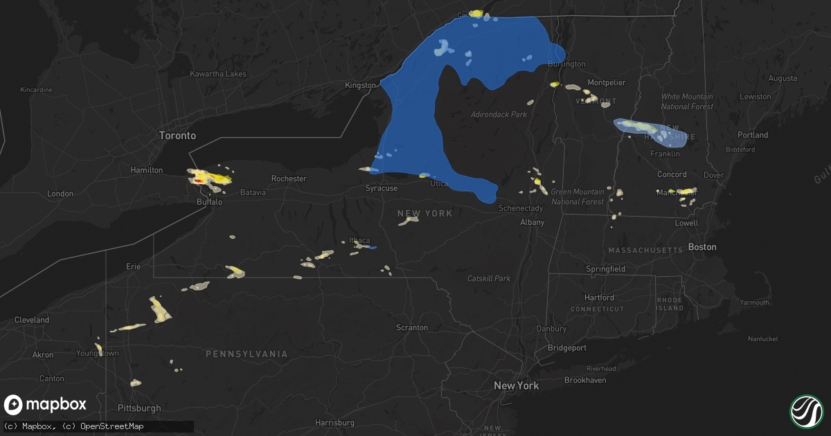
Hail Map in New York on July 20, 2021
Get this storm
July 20 map
$229
one time, instant access
Download today. No call, no setup
Keep the $229
Bought the map and want the full workflow? Apply the entire $229 to a subscription within 7 days. None of it is wasted.
Every map, not just this one
This buys you this map. Subscription and you get every map we run, in the markets you choose from a few cities to whole states to nationwide. Plus real-time alerts the moment a storm fires.
Contact data
Name, contact info, occupancy, even credit band for addresses in the footprint. You go from where it hit to who to call.
Become the source they trust
Unlimited branding weather history reports on demand. You already have the documented answer ready for the property owner, and you are the one who showed up with it.
Property data and RoofTrace estimates
Pull up any address you have got, its value and the exact code rules for that jurisdiction, straight from One Click Code. Then RoofTrace estimates the squares, pitch, and roof value, priced the way you price.
Storm reports in New York
New York
| Date | Description |
|---|---|
| 07/20/20216:55 PM CDT | Trees and wires down |
| 07/20/20216:55 PM CDT | Two trees down on county road 13. |
| 07/20/20216:45 PM CDT | Numerous trees down. |
| 07/20/20216:45 PM CDT | Several trees down |
| 07/20/20216:41 PM CDT | Strong thunderstorm winds knocked down tree on road. |
| 07/20/20216:40 PM CDT | Large tree on wires result in a fire. |
| 07/20/20216:32 PM CDT | Wires down and arcing. E german street and lake street. |
| 07/20/20216:30 PM CDT | Numerous trees down. |
| 07/20/20216:27 PM CDT | Strong thunderstorm winds broke large tree limbs and power pole broken. |
| 07/20/20216:21 PM CDT | Strong thunderstorm winds knocked down tree on utica/jones road intersection. |
| 07/20/20216:13 PM CDT | Strong thunderstorm winds knocked down tree on indian mound road. |
| 07/20/20216:11 PM CDT | Strong thunderstorm winds knocked down tree on road. |
| 07/20/20216:02 PM CDT | Strong thunderstorms winds knocked tree down along road. |
| 07/20/20215:55 PM CDT | Strong thunderstorm winds knocked down tree on vehicle in delta lake state park. No injuries reported as woman in car refused treatment. |
| 07/20/20215:52 PM CDT | Trees down in clarence. |
| 07/20/20215:52 PM CDT | Trees on road... Crews dispatched. |
| 07/20/20215:49 PM CDT | Strong thunderstorm winds knocked down tree on wires. |
| 07/20/20215:49 PM CDT | Strong thunderstorm winds knocked down tree on road. |
| 07/20/20215:42 PM CDT | Trees and wires down in lyonsdale. |
| 07/20/20215:42 PM CDT | Trees and wires down. |
| 07/20/20215:42 PM CDT | Strong thunderstorm winds knocked down tree on wires. |
| 07/20/20215:38 PM CDT | Trees down on railraod tracks. |
| 07/20/20215:31 PM CDT | Trees and wires down in brantingham. |
| 07/20/20215:27 PM CDT | Strong thunderstorm winds knocked down tree on wires and across elpis rd. |
| 07/20/20215:27 PM CDT | Strong thunderstorm winds knocked on tree on prestonhill rd. |
| 07/20/20215:25 PM CDT | Arcing power lines down. |
| 07/20/20215:23 PM CDT | Reports of widespread damage including numerous downed trees and powerlines in the town of constantia. |
| 07/20/20215:17 PM CDT | Strong thunderstorm winds knocked down tree on wires. |
| 07/20/20215:10 PM CDT | Reports of widespread damage including downed trees and powerlines in the town of amboy. |
| 07/20/20215:08 PM CDT | Trees and wires down in new bremen. |
| 07/20/20215:02 PM CDT | Corrects previous hail report from lewiston. Golf ball to tennis ball sized hail reported in the town of lewiston. |
| 07/20/20215:01 PM CDT | Trees down. |
| 07/20/20215:01 PM CDT | Large tree down across oregon plains road. |
| 07/20/20215:00 PM CDT | Report of trees and wires down in the town of schroeppel. |
| 07/20/20214:55 PM CDT | Widespread damage reported in the township of orwell... Including numerous trees and wires down. |
| 07/20/20214:52 PM CDT | Reports of widespread damage in the town of phoenix with numerous trees and wires down. |
| 07/20/20214:51 PM CDT | Trees down in pendleton. |
| 07/20/20214:48 PM CDT | Trees down. |
| 07/20/20214:48 PM CDT | Trees down. |
| 07/20/20214:38 PM CDT | Large tree snapped in half. |
| 07/20/20214:37 PM CDT | Trees down. |
| 07/20/20214:32 PM CDT | Trees down. |
| 07/20/20214:30 PM CDT | Trees down. |
| 07/20/20214:29 PM CDT | Very old tree down. |
| 07/20/20214:24 PM CDT | Trees down in royalton. |
| 07/20/20214:22 PM CDT | Quarter-sized hail. |
| 07/20/20214:21 PM CDT | Trees down. |
| 07/20/20214:20 PM CDT | A local report indicates 1.25 inch wind near 1 S ST. REGIS |
| 07/20/20214:07 PM CDT | Quarter sized |
| 07/20/20214:06 PM CDT | Tree down on wire. |
| 07/20/20214:05 PM CDT | Quarter sized |
| 07/20/20214:05 PM CDT | Numerous trees and powerlines down. |
| 07/20/20214:05 PM CDT | Numerous trees down and pea-sized hail. |
| 07/20/20214:00 PM CDT | One large tree and numerous small trees down. |
| 07/20/20213:58 PM CDT | Quarter sized |
| 07/20/20213:58 PM CDT | Report of trees and wires down in the town of antwerp. |
| 07/20/20213:57 PM CDT | Quarter sized |
| 07/20/20213:48 PM CDT | Large tree down. |
| 07/20/20213:43 PM CDT | Hail reported on howard avenue in lockport. |
| 07/20/20213:43 PM CDT | Report of a utility pole with a tree down on hunter road in the town of plessis. |
| 07/20/20213:41 PM CDT | Half dollar |
| 07/20/20213:39 PM CDT | Trees and wires down in the town of alexandria. |
| 07/20/20213:35 PM CDT | A local report indicates 1.00 inch wind near 1 NE LOCKPORT |
| 07/20/20213:35 PM CDT | Trees down. |
| 07/20/20213:34 PM CDT | Report from mping: ping pong ball |
| 07/20/20213:32 PM CDT | Numerous trees down. |
| 07/20/20213:31 PM CDT | Awos time estimated. |
| 07/20/20213:31 PM CDT | A local report indicates 63 MPH wind near 1 NW OGDENSBURG |
| 07/20/20213:30 PM CDT | Boat flipped and tree down in waddington. |
| 07/20/20213:27 PM CDT | Corrects previous tstm wnd dmg report from 3 se alexandria bay. Trees and wires down in the town of alexandria. |
| 07/20/20213:25 PM CDT | Numerous trees and power lines down in the city of ogdensburg. |
| 07/20/20213:25 PM CDT | Reports of trees and wires down in the town of clayton. |
| 07/20/20213:23 PM CDT | A local report indicates 63 MPH wind near OGDENSBURG AIRPORT |
| 07/20/20213:06 PM CDT | A local report indicates 1.00 inch wind near 1 WNW CAMBRIA CENTER |
| 07/20/20211:54 PM CDT | Hail slightly larger than a quarter just south of schuylerville. Time estimated by radar. |
| 07/20/20211:30 PM CDT | Tree down near state route 50 and king rd. Time estimated from radar |
| 07/20/20211:30 PM CDT | Hail slightly larger than a quarter. Time adjusted based on report. Corrected with more precise location. |
| 07/20/20216:29 AM CDT | At 1128 PM EDT, severe thunderstorms were located along a line extending from 6 miles southeast of Gowanda to near Falconer, moving east at 35 mph. HAZARD...60 mph wind gusts. SOURCE...Radar indicated. IMPACT...Expect damage to roofs, siding, and trees. Locations impacted include... Olean, Salamanca, Allegany State Park, Ashford, Allegany, Franklinville, Cuba, St. Bonaventure, Ashford Hollow and Weston Mills. This includes Interstate 86 between exits 13 and 31. |
| 07/20/20215:19 AM CDT | At 1018 PM EDT, a severe thunderstorm was located 9 miles northwest of Westfield, or 18 miles west of Fredonia, moving southeast at 45 mph. HAZARD...60 mph wind gusts. SOURCE...Radar indicated. IMPACT...Expect damage to roofs, siding, and trees. Locations impacted include... Jamestown, Dunkirk, Fredonia, Westfield, Lakewood, Falconer, Mayville, Clymer, Long Point State Park and Jamestown West. This includes the following highways... Interstate 90 between exits 61 and 59. Interstate 86 between exits 4 and 14. |
| 07/20/20213:58 AM CDT | At 856 PM EDT, severe thunderstorms were located along a line extending from near Hartwick to near Sanitaria Springs, moving east at 30 mph. HAZARD...60 mph wind gusts and quarter size hail. SOURCE...Radar indicated. IMPACT...Hail damage to vehicles is expected. Expect wind damage to roofs, siding, and trees. Locations impacted include... Oneonta, Sidney, Walton, Delhi, Davenport, Guilford, Sanford, Worcester, Middlefield and Hartwick. |
| 07/20/20213:40 AM CDT | At 839 PM EDT, severe thunderstorms were located along a line extending from Sharon Springs to Richmondville to near Schenevus, moving east at 25 mph. HAZARD...60 mph wind gusts. SOURCE...Radar indicated. IMPACT...Expect damage to roofs, siding, and trees. Locations impacted include... Cobleskill, Jefferson, Middleburgh, Gilboa, Summit, Schoharie, Richmondville, Sharon Springs, Livingstonville, North Blenheim, Breakabeen, Central Bridge, Carlisle, Sharon, Seward, Conesville, Esperance, Zeh Corners, Beekman Corners and West Richmondville. |
| 07/20/20213:39 AM CDT | At 839 PM EDT, a severe thunderstorm was located near Arcade, or 19 miles south of East Aurora, moving east at 25 mph. HAZARD...60 mph wind gusts and quarter size hail. SOURCE...Radar indicated. IMPACT...Minor damage to vehicles is possible. Expect wind damage to roofs, siding, and trees. Locations impacted include... Letchworth State Park, Arcade, Franklinville, Belfast, Rushford, Houghton, Chaffee, Portageville, Yorkshire and Sardinia. This includes Interstate 86 near exit 30. |
| 07/20/20213:31 AM CDT | At 830 PM EDT, severe thunderstorms were located along a line extending from Whitney Point to near Willseyville to near Wedgewood, moving east at 30 mph. HAZARD...60 mph wind gusts and quarter size hail. SOURCE...Radar indicated. IMPACT...Hail damage to vehicles is expected. Expect wind damage to roofs, siding, and trees. Locations impacted include... Binghamton, Vestal, Johnson City, Endicott, Barton, Horseheads, Maine, Waverly, Owego and Danby. |
| 07/20/20213:28 AM CDT | At 828 PM EDT, a severe thunderstorm was located near Bradford, moving east at 40 mph. HAZARD...60 mph wind gusts. SOURCE...Radar indicated. IMPACT...Expect damage to roofs, siding, and trees. Locations impacted include... Olean, Salamanca, Wellsville, Allegany State Park, Allegany, Cuba, St. Bonaventure, Weston Mills, Hinsdale and Friendship. This includes Interstate 86 between exits 23 and 27, and near exit29. |
| 07/20/20213:17 AM CDT | At 816 PM EDT, a severe thunderstorm was located over Fonda, moving east at 40 mph. HAZARD...60 mph wind gusts. SOURCE...Radar indicated. IMPACT...Expect damage to roofs, siding, and trees. Locations impacted include... Schenectady, Rotterdam, Amsterdam, Gloversville, Johnstown, Scotia, Fonda, Glenville, Niskayuna, Hagaman, Round Lake, Fort Johnson, Tribes Hill, Country Knolls, Rotterdam Junction, Alplaus, East Glenville, Burnt Hills, Pattersonville-Rotterdam Junction and Malta. |
| 07/20/20213:05 AM CDT | At 805 PM EDT, severe thunderstorms were located along a line extending from Leonardsville to near Marathon, moving east at 70 mph. HAZARD...60 mph wind gusts and quarter size hail. SOURCE...Radar indicated. IMPACT...Hail damage to vehicles is expected. Expect wind damage to roofs, siding, and trees. Locations impacted include... Oneonta, Norwich, Sidney, Walton, Delhi, Davenport, Guilford, Roxbury, Worcester and Middlefield. |
| 07/20/20212:58 AM CDT | At 758 PM EDT, a severe thunderstorm was located over Hornby, or 7 miles north of Corning, moving east at 30 mph. HAZARD...60 mph wind gusts and quarter size hail. SOURCE...Radar indicated. IMPACT...Hail damage to vehicles is expected. Expect wind damage to roofs, siding, and trees. Locations impacted include... Horseheads, Elmira Heights, Erin, Catharine, Hornby, Cayuta, Van Etten, Millport, Meads Creek and Breesport. |
| 07/20/20212:41 AM CDT | At 740 PM EDT, severe thunderstorms were located along a line extending from 10 miles southwest of Johnsburg to near Caroga Lake to near Herkimer, moving east at 30 mph. HAZARD...60 mph wind gusts. SOURCE...Radar indicated. IMPACT...Expect damage to roofs, siding, and trees. Locations impacted include... Gloversville, Johnstown, Ilion, Herkimer, Little Falls, Warrensburg, Fonda, Lake George Village, Mohawk, Frankfort, Corinth, Dolgeville, St. Johnsville, Ephratah, Broadalbin, Edinburg, Northville, Mayfield, Wells and Cranberry Creek. |
| 07/20/20212:40 AM CDT | At 740 PM EDT, a severe thunderstorm was located over Danby, or near Ithaca, moving east at 40 mph. HAZARD...60 mph wind gusts and nickel size hail. SOURCE...Radar indicated. IMPACT...Expect damage to roofs, siding, and trees. Locations impacted include... Ithaca, Johnson City, Maine, Cayuga Heights, Danby, Caroline, Nanticoke, Berkshire, Richford and Newark Valley. |
| 07/20/20212:38 AM CDT | At 737 PM EDT, a severe thunderstorm was located over Honeoye Falls, or 11 miles south of Brighton, moving east at 15 mph. HAZARD...60 mph wind gusts. SOURCE...Radar indicated. IMPACT...Expect damage to roofs, siding, and trees. Locations impacted include... Geneva, Canandaigua, Newark, Lyons, Palmyra, Victor, Honeoye Falls, Bristol, Lima and Clifton Springs. This includes the following highways... Interstate 390 near exit 11. Interstate 90 between exits 46 and 42. |
| 07/20/20212:02 AM CDT | At 701 PM EDT, severe thunderstorms were located along a line extending from 9 miles south of McKeever to Holland Patent to Verona, moving east at 30 mph. HAZARD...60 mph wind gusts. SOURCE...Radar indicated. IMPACT...Expect damage to roofs, siding, and trees. Locations impacted include... Ilion, Herkimer, Little Falls, Mohawk, Frankfort, Dolgeville, Ohio, West Winfield, Newport, Stratford, Middleville, Poland, Cold Brook, Jordanville, Northwood, Cedarville, Russia, Fairfield, Elizabethtown and Norway. |
| 07/20/20211:52 AM CDT | At 652 PM EDT, a severe thunderstorm was located 12 miles north of Ohio, or 16 miles south of Old Forge, moving east at 20 mph. HAZARD...60 mph wind gusts and quarter size hail. SOURCE...Radar indicated. IMPACT...Hail damage to vehicles is expected. Expect wind damage to roofs, siding, and trees. Locations impacted include... Caswell Lake, Mountain Home, Hoffmeister, Atwell, West Canada Lakes and Herkimer Landing. |
| 07/20/20211:44 AM CDT | At 644 PM EDT, severe thunderstorms were located along a line extending from 8 miles north of Boonville to near Delta Lake to near Verona, moving east at 70 mph. HAZARD...60 mph wind gusts and quarter size hail. SOURCE...Radar indicated. IMPACT...Hail damage to vehicles is expected. Expect wind damage to roofs, siding, and trees. Locations impacted include... Utica, Rome, Kirkland, Verona, Westmoreland, Trenton, Paris, Deerfield, Floyd and Whitesboro. |
| 07/20/20211:37 AM CDT | At 637 PM EDT, a severe thunderstorm was located over Amherst, moving southeast at 15 mph. HAZARD...60 mph wind gusts and quarter size hail. SOURCE...Radar indicated. IMPACT...Minor damage to vehicles is possible. Expect wind damage to roofs, siding, and trees. Locations impacted include... Buffalo, Cheektowaga, West Seneca, North Tonawanda, Clarence, Depew, Amherst, Tonawanda, Lancaster and Williamsville. This includes Interstate 90 between exits 52A and 49. |
| 07/20/20211:31 AM CDT | At 630 PM EDT, a line of severe thunderstorms over northeast New York was located along a line extending from near Perry Mills to near Harkness to 9 miles west of Schroon Falls, moving east at 40 mph. HAZARD...60 mph wind gusts and quarter size hail. SOURCE...Radar indicated. IMPACT...Expect wind damage to trees and powerlines. Minor hail damage to vehicles is possible. Locations impacted include... Essex Junction, Plattsburgh International Airport, Burlington, Burlington International Airport, Plattsburgh, Middlebury, South Burlington, Vergennes, Peru, Beekmantown, Schuyler Falls, Moriah, Chazy, Saranac, Mooers, Altona, Willsboro, Crown Point, Morrisville and Enosburg Falls. |
| 07/20/20211:07 AM CDT | At 606 PM EDT, severe thunderstorms were located along a line extending from 8 miles south of Star Lake to 6 miles west of Oswego, moving east at 30 mph. HAZARD...60 mph wind gusts and quarter size hail. SOURCE...Radar indicated. IMPACT...Minor damage to vehicles is possible. Expect wind damage to roofs, siding, and trees. Locations impacted include... Oswego, Fulton, Sandy Island Beach State Park, Fair Haven Beach State Park, Lowville, Pulaski, Adams, Redfield, Selkirk Shores State Park and Highmarket. This includes Interstate 81 between exits 33 and 41. |
| 07/20/202112:57 AM CDT | At 556 PM EDT, severe thunderstorms were located along a line extending from Barnes Corners to near Brewerton, moving east at 50 mph. HAZARD...60 mph wind gusts and quarter size hail. SOURCE...Radar indicated. IMPACT...Hail damage to vehicles is expected. Expect wind damage to roofs, siding, and trees. Locations impacted include... Rome, Lee, Verona, Vienna, Camden, Boonville, Vernon, Florence, Sylvan Beach and Ava. |
| 07/20/202112:50 AM CDT | At 548 PM EDT, a line of severe thunderstorms over northern New York was located along a line extending from North Burke to Debar Mountain to 8 miles southwest of Axton Landing, moving east at 45 mph. HAZARD...60 mph wind gusts and quarter size hail. SOURCE...Radar indicated. IMPACT...Expect wind damage to trees and powerlines as there have been numerous reports or trees and powerlines down along with power outages. Minor hail damage to vehicles is possible. Locations impacted include... Saranac Lake, Adirondack Regional Airport, Lake Placid, Plattsburgh, Tupper Lake, Peru, Beekmantown, Schuyler Falls, Chazy, Saranac, Mooers, Altona, Wilmington, Keene, Ellenburg Depot, Champlain, Bryants Mill, Wawbeek, Burke and Churubusco. |
| 07/20/202112:43 AM CDT | At 542 PM EDT, a severe thunderstorm was located over Fulton, moving east at 25 mph. HAZARD...60 mph wind gusts and quarter size hail. SOURCE...Radar indicated. IMPACT...Minor damage to vehicles is possible. Expect wind damage to roofs, siding, and trees. Locations impacted include... Fulton, Central Square, Battle Island State Park, Hastings, Volney, Constantia, West Monroe, Palermo, Phoenix and Cleveland. This includes Interstate 81 between exits 32 and 33. |
| 07/20/202112:35 AM CDT | At 533 PM EDT, severe thunderstorms were located over Essex County, New York, extending from near Keene to Wadhams, moving northeast at 10 mph. HAZARD...60 mph wind gusts and quarter size hail. SOURCE...Radar indicated. IMPACT...Minor hail damage to vehicles is possible. Expect wind damage to trees and powerlines. Locations impacted include... Essex, Willsboro, Westport, Elizabethtown, Charlotte, St. George, Kingsland Bay State Park, Shelburne, Ferrisburgh, Hinesburg, Williston, Lewis, Fort Cassin Point, Mcneil Cove, Sloop Island, Shelburne Falls, Wings Point, Town Farm Bay, Meach Island and North West Bay. |
| 07/20/202112:30 AM CDT | At 529 PM EDT, a severe thunderstorm was located over Lewiston, or near Niagara Falls, moving east at 20 mph. HAZARD...60 mph wind gusts and quarter size hail. SOURCE...Radar indicated. IMPACT...Minor damage to vehicles is possible. Expect wind damage to roofs, siding, and trees. Locations impacted include... Buffalo, Cheektowaga, North Tonawanda, Clarence, Lockport, Kenmore, Depew, Tonawanda, Amherst and Medina. This includes Interstate 90 between exits 51 and 48A. |
| 07/20/202112:13 AM CDT | At 512 PM EDT, severe thunderstorms were located along a line extending from 6 miles southwest of Fowler to 13 miles west of Stony Point, moving east at 35 mph. HAZARD...60 mph wind gusts and penny size hail. SOURCE...Radar indicated. IMPACT...Expect damage to roofs, siding, and trees. Locations impacted include... Watertown, Sandy Island Beach State Park, Fort Drum, Stony Point, Carthage, Lowville, Pulaski, West Carthage, Adams and Dexter. This includes Interstate 81 between exits 34 and 48. |
| 07/19/202111:44 PM CDT | At 442 PM EDT, a line of severe thunderstorms was located from near St. Regis, New York to 18 miles southwest of Nelson Corner, New York moving east at 40 mph. HAZARD...70 mph wind gusts and quarter size hail. SOURCE...Radar indicated. IMPACT...Expect considerable tree damage. Wind damage is also likely to mobile homes, roofs, and outbuildings. Minor hail damage to vehicles is possible. Locations impacted include... Potsdam, Gouverneur, Canton, Massena, Norfolk, Oswegatchie, Moira, De Kalb, Bangor, Fowler, Parishville, Fort Covington, Colton, Bombay, Bryants Mill, Massena International Airport - Richards Field, Helena, Burke, Cranberry Lake and Brushton. |
| 07/19/202111:42 PM CDT | At 442 PM EDT, a severe thunderstorm was located near Youngstown, or 9 miles north of Niagara Falls, moving east at 20 mph. HAZARD...60 mph wind gusts and quarter size hail. SOURCE...Radar indicated. IMPACT...Minor damage to vehicles is possible. Expect wind damage to roofs, siding, and trees. Locations impacted include... Lewiston, Youngstown, Fort Niagara State Park and Model City. |
| 07/19/202111:23 PM CDT | At 423 PM EDT, a severe thunderstorm was located near Lockport, moving east at 15 mph. HAZARD...60 mph wind gusts and quarter size hail. SOURCE...Radar indicated. IMPACT...Minor damage to vehicles is possible. Expect wind damage to roofs, siding, and trees. Locations impacted include... Lockport, Newfane, Pendleton, Pembroke, Akron, Middleport, Sanborn, Cambria Center, Pendleton Center and Ransomville. |
| 07/19/202111:21 PM CDT | Multiple reports of wires down in and around olean. |
| 07/19/202111:08 PM CDT | At 407 PM EDT, severe thunderstorms were located along a line extending from 13 miles northwest of Morristown to 15 miles west of Cedar Point State Park, moving east at 45 mph. HAZARD...60 mph wind gusts and quarter size hail. SOURCE...Radar indicated. IMPACT...Minor damage to vehicles is possible. Expect wind damage to roofs, siding, and trees. Locations impacted include... Watertown, Fort Drum, Carthage, West Carthage, Clayton, Dexter, Glen Park, Herrings, Redwood and Kring Point State Park. This includes Interstate 81 between exits 42 and 52. |
| 07/19/202110:53 PM CDT | At 351 PM EDT, severe thunderstorms were located west of the Saint Lawrence River along a line extending from 23 miles northwest of St. Lawrence State Park to 47 miles west of Cedar Island State Park, moving east at 45 mph. HAZARD...60 mph wind gusts and quarter size hail. SOURCE...Radar indicated. IMPACT...Expect wind damage to trees and powerlines. Minor hail damage to vehicles is possible. Locations impacted include... Massena, Canton, Potsdam, Ogdensburg, Norfolk, Lisbon, Louisville, De Kalb, Fort Covington, Bombay, Rensselaer Falls, Morley, Norwood, Edwardsville, Massena International Airport - Richards Field, Helena, Chipman, Brasher Falls, Heuvelton and Waddington. |
| 07/19/202110:30 PM CDT | Multiple reports of trees down in leon area. |
| 07/19/202110:23 PM CDT | At 322 PM EDT, a severe thunderstorm was located over Fort Niagara State Park, or 12 miles north of Niagara Falls, moving east at 10 mph. HAZARD...60 mph wind gusts and quarter size hail. SOURCE...Radar indicated. IMPACT...Minor damage to vehicles is possible. Expect wind damage to roofs, siding, and trees. Locations impacted include... Lockport, Newfane, Pendleton, Lewiston, Youngstown, Fort Niagara State Park, Sanborn, Wilson, Cambria Center and Olcott. |
| 07/19/20219:52 PM CDT | Trees and wires down on putnam rd. |
| 07/19/20219:40 PM CDT | Trees down on route 380. |
| 07/19/20219:26 PM CDT | At 225 PM EDT, a severe thunderstorm was located near Saratoga Springs, moving southeast at 15 mph. HAZARD...60 mph wind gusts and quarter size hail. SOURCE...Radar indicated. IMPACT...Hail damage to vehicles is expected. Expect wind damage to roofs, siding, and trees. Locations impacted include... Saratoga Springs, Greenwich, Gates, Northumberland, Easton, Schuylerville, Victory, Deans Corners, Gurn Spring, Bacon Hill, Coveville, Battenville, Jewell Corner, Hickeys Corners, Center Falls, Grangerville, Middle Falls, Fly Summit, North Easton and Bald Mountain. |
| 07/19/20218:42 PM CDT | Trees and wires down. Time estimated by radar. |
| 07/19/20218:30 PM CDT | Trees and wires down along route 346 in petersburg |
| 07/19/20218:25 PM CDT | Trees and wires down. |
| 07/19/20218:25 PM CDT | Trees and wires down. Time estimated by radar. Outflow boundary ahead of the line of thunderstorms. |
| 07/19/20218:23 PM CDT | Trees and wires down on sunset road. Outflow boundary ahead of the line of thunderstorms. |
| 07/19/20218:18 PM CDT | Tree down on road. State route 22. |
| 07/19/20218:16 PM CDT | Trees down in wellsville. |
| 07/19/20218:15 PM CDT | Multiple trees and branches down. Time estimated by radar. |
| 07/19/20218:14 PM CDT | Tree down on road. County route 153 |
| 07/19/20218:10 PM CDT | Trees and wired down. |
| 07/19/20218:06 PM CDT | Tree down on road. East lake road. |
| 07/19/20218:05 PM CDT | Tree down on wires. Time estimated by radar. |
| 07/19/20218:03 PM CDT | Multiple trees down. County route 47. |
| 07/19/20218:00 PM CDT | Tree on vehicle. |
| 07/19/20218:00 PM CDT | Multiple trees and branches down. Time estimated by radar. |
| 07/19/20217:57 PM CDT | Trees down in bolivar. |
| 07/19/20217:55 PM CDT | Tree on wires. County route 30 |
| 07/19/20217:53 PM CDT | Trees reported down in freedom. |
| 07/19/20217:50 PM CDT | Down tree on putnam road. |
| 07/19/20217:45 PM CDT | Tree on a house in scotia. |
| 07/19/20217:44 PM CDT | Tree down on road. State route 4. |
| 07/19/20217:42 PM CDT | Multiple reports of trees down in portville. |
| 07/19/20217:40 PM CDT | Trees and wires down. Time estimated by radar. |
| 07/19/20217:40 PM CDT | A large branch was downed between route 29 and the saratoga county airport that required heavy equipment to be removed |
| 07/19/20217:36 PM CDT | Multiple reports of trees down in olean. |
| 07/19/20217:30 PM CDT | Trees and wires down. |
| 07/19/20217:30 PM CDT | Trees and wires down. |
| 07/19/20217:29 PM CDT | Strong thunderstorm winds knocked down tree on road. |
| 07/19/20217:25 PM CDT | Trees and wires down. Time estimated by radar. |
| 07/19/20217:19 PM CDT | Strong thunderstorm winds knocked down tree on road. |
| 07/19/20217:18 PM CDT | Tree down on wires and house. Time estimated by radar. |
| 07/19/20217:18 PM CDT | Multiple trees down on cooley rd and rt 414. Time estimated by radar. |
| 07/19/20217:14 PM CDT | Thunderstorm dropped quarter sized hail. |
| 07/19/20217:09 PM CDT | Primary wires down and fire. State route 29a |
| 07/19/20217:08 PM CDT | Strong thunderstorm winds knocked down tree on roadway. |
| 07/19/20217:03 PM CDT | Tree down on wheat road. |
All States Impacted by Hail Map on July 20, 2021
Cities Impacted by Hail Map on July 20, 2021
- Payson, AZ
- Painted Post, NY
- Beaver Dams, NY
- Rome, NY
- Verona, NY
- Woodhull, NY
- Troupsburg, NY
- Knoxville, PA
- Niagara Falls, NY
- Youngstown, NY
- Ransomville, NY
- Niagara University, NY
- Lewiston, NY
- Roxbury, VT
- Derry, NH
- Londonderry, NH
- Mission, TX
- Chester, NH
- Raymond, NH
- Auburn, NH
- Candia, NH
- Madrid, NY
- Canton, NY
- Mexico, NY
- Granville, VT
- Roseglen, ND
- Garrison, ND
- Minden City, MI
- Harbor Beach, MI
- Ruth, MI
- Olean, NY
- Callery, PA
- Evans City, PA
- Zelienople, PA
- Mars, PA
- Cranberry Township, PA
- New Town, ND
- Keene, ND
- Watford City, ND
- Utica, PA
- Stoneboro, PA
- Greenville, PA
- Clarks Mills, PA
- Carlton, PA
- Sandy Lake, PA
- Hadley, PA
- Fredonia, PA
- Saint Regis Falls, NY
- Potsdam, NY
- Parishville, NY
- Constable, NY
- Watkins Glen, NY
- Campbell, NY
- Corning, NY
- North Hudson, NY
- Goffstown, NH
- Schuylerville, NY
- Saratoga Springs, NY
- Gansevoort, NY
- Encino, TX
- Harlingen, TX
- Weirton, WV
- Colliers, WV
- Sanborn, NY
- Lockport, NY
- Brookfield, VT
- East Randolph, VT
- Randolph Center, VT
- Randolph, VT
- Kinde, MI
- Filion, MI
- Westmoreland, NH
- Keene, NH
- Edinburg, TX
- Marana, AZ
- Lebanon, NH
- Enfield, NH
- Eloy, AZ
- Essex, NY
- Westport, NY
- Titusville, PA
- Oil City, PA
- Pleasantville, PA
- Newfield, NY
- Spencer, NY
- Ithaca, NY
- Brooktondale, NY
- Windham, NH
- Johnsonville, NY
- Cambridge, NY
- Schaghticoke, NY
- Greenwich, NY
- Valley Falls, NY
- Buffalo, NY
- Zolfo Springs, FL
- Campbell, OH
- Vienna, OH
- Hubbard, OH
- Girard, OH
- Youngstown, OH
- Niles, OH
- Delevan, NY
- Tijeras, NM
- Fort McCoy, FL
- Northfield, MA
- Altmar, NY
- Fulton, NY
- Pennellville, NY
- Phoenix, NY
- Hooksett, NH
- Manchester, NH
- Grace, ID
- Allegany, NY
- Limestone, NY
- Rensselaer Falls, NY
- Hogansburg, NY
- Centerville, PA
- Rumney, NH
- Santa Fe, NM
- Warren, VT
- Port Hope, MI
- Bancroft, ID
- Waitsfield, VT
- Cameron Mills, NY
- Bristol, VT
- Bunnell, FL
- Hebron, NH
- Hampstead, NH
- Sandown, NH
- New Hampton, NH
- Bristol, NH
- Westfield, PA
- Osceola, PA
- Cedar Crest, NM
- Parish, NY
- Central Square, NY
- North Branch, MI
- Fort Edward, NY
- Queensbury, NY
- Kingsville, TX
- East Thetford, VT
- Thetford Center, VT
- Lyme, NH
- Fort Covington, NY
- Fort Sumner, NM
- Prescott, AZ
- Haines City, FL
- Warren, PA
- Tucson, AZ
- Plymouth, NY
- South Otselic, NY
- Norwich, VT
- Hanover, NH
- South Strafford, VT
- Kittanning, PA
- Templeton, PA
- Espanola, NM
- Santa Cruz, NM
- Addison, NY
- Roberts, MT
- Marcy, NY
- Sherburne, NY
- Pitcher, NY
- North Pitcher, NY
- Smyrna, NY
- Spartansburg, PA
- Transfer, PA
- Show Low, AZ
- Oxford, MI
- Metamora, MI
- Russell, PA
- Canaan, NH
- Sharon, VT
- Brasher Falls, NY
- Moira, NY
- Bombay, NY
- Lisbon, NY
- Fowler, OH
- Hydetown, PA
- Rouseville, PA
- Van Etten, NY
- Cayuta, NY
- Middleport, NY
- Chelsea, MI
- Corinth, NY
- Hannibal, NY
- Brewerton, NY
- Salem, NY
- West Chesterfield, NH
- Chesterfield, NH
- Putney, VT
- Franklin, PA
- Starksboro, VT
- Vergennes, VT
- New Haven, VT
- North Ferrisburgh, VT
- Ferrisburgh, VT
- Owego, NY
- Endicott, NY
- Akron, NY
- Gasport, NY
- Getzville, NY
- Tonawanda, NY
- Clarence Center, NY
- East Amherst, NY
- North Tonawanda, NY
- Pontiac, MI
- Auburn Hills, MI
- Lake Orion, MI
- Newfane, NY
- Burt, NY
- Sanbornton, NH
- South Colton, NY
- Edgewater, FL
- Stillwater, NY
- Waterford, MI
- Bloomfield Hills, MI
- Keego Harbor, MI
- West Bloomfield, MI
- Appleton, NY
- Schuyler Falls, NY
- Sullivan City, TX
- La Joya, TX
- Cameron, NY
- Westons Mills, NY
- Center Harbor, NH
- Eldred, PA
- Bradford, PA
- Derrick City, PA
- Portville, NY
- Vernon, VT
- Winchester, NH
- Hinsdale, NH
- Au Sable Forks, NY
- Francestown, NH
- New Boston, NH
- Weare, NH
- Attica, MI
- Dryden, MI
- Lapeer, MI
- Plymouth, NH
- Ashland, NH
- Brown City, MI
- Clarence, NY
- Renfrew, PA
- Butler, PA
- Valencia, PA
- Walpole, NH
- Oracle, AZ
- Rimersburg, PA
- Ballston Spa, NY
- Vestal, NY
- Alpine, WY
- Etna, WY
- Forestville, MI
- Palms, MI
- Astor, FL
- Alpine, NY
- Burdett, NY
- Odessa, NY
- Dayton, PA
- New Bethlehem, PA
- Binghamton, NY
- Irvine, PA
- Youngsville, PA
- Millers Falls, MA
- Erving, MA
- Ortonville, MI
- Wibaux, MT
- Golva, ND
- Baker, MT
- Manchester, MI
- Mirror Lake, NH
- Holderness, NH
- Hill, NH
- Strafford, VT
- Meredith, NH
- South Royalton, VT
- Belmont, NH
- Gilford, NH
- Etna, NH
- Alton Bay, NH
- Moultonborough, NH
- Laconia, NH
- Chase Mills, NY
- Palatine Bridge, NY
- Fort Drum, NY
- Rainbow Lake, NY
- Keeseville, NY
- Greig, NY
- Mooers Forks, NY
- Mallory, NY
- Waddington, NY
- Watertown, NY
- Pulaski, NY
- Westernville, NY
- Malone, NY
- Sprakers, NY
- Castorland, NY
- Hammond, NY
- Cold Brook, NY
- Jay, NY
- Rodman, NY
- Dexter, NY
- Peru, NY
- Edwards, NY
- Ellenburg Depot, NY
- Nicholville, NY
- Russell, NY
- Caroga Lake, NY
- Lacona, NY
- Turin, NY
- Massena, NY
- Colton, NY
- De Peyster, NY
- Childwold, NY
- Brushton, NY
- Saranac, NY
- West Chazy, NY
- Canajoharie, NY
- Saranac Lake, NY
- West Monroe, NY
- Utica, NY
- Forestport, NY
- Chaumont, NY
- Hastings, NY
- Dolgeville, NY
- Cranberry Lake, NY
- West Leyden, NY
- Heuvelton, NY
- Frankfort, NY
- Fultonville, NY
- North Lawrence, NY
- Baldwinsville, NY
- De Kalb Junction, NY
- Brownville, NY
- Saint Johnsville, NY
- Remsen, NY
- Theresa, NY
- Newport, NY
- West Stockholm, NY
- Poland, NY
- Black River, NY
- Sandy Creek, NY
- Fonda, NY
- Port Leyden, NY
- Herkimer, NY
- Norwood, NY
- Redwood, NY
- Oriskany, NY
- Grand Isle, VT
- Blossvale, NY
- Camden, NY
- Ellenburg Center, NY
- Adams Center, NY
- Bloomingdale, NY
- Chateaugay, NY
- Gloversville, NY
- Philadelphia, NY
- Clayton, NY
- Norfolk, NY
- Mooers, NY
- Carthage, NY
- Paul Smiths, NY
- Clay, NY
- Calcium, NY
- Middleville, NY
- Harrisville, NY
- Wellesley Island, NY
- Brier Hill, NY
- Churubusco, NY
- Little Falls, NY
- Wilmington, NY
- Cadyville, NY
- Salisbury Center, NY
- Barneveld, NY
- Constantia, NY
- Colchester, VT
- Lake Clear, NY
- Brantingham, NY
- La Fargeville, NY
- Cleveland, NY
- North Bangor, NY
- Boonville, NY
- Alexandria Bay, NY
- Redford, NY
- Prospect, NY
- Owls Head, NY
- Gouverneur, NY
- Glenfield, NY
- Lee Center, NY
- Antwerp, NY
- Hermon, NY
- Fort Plain, NY
- Westdale, NY
- Williamstown, NY
- Tupper Lake, NY
- Lowville, NY
- Stratford, NY
- Ava, NY
- Nelliston, NY
- Vermontville, NY
- Lyon Mountain, NY
- Alder Creek, NY
- Evans Mills, NY
- Mohawk, NY
- Morrisonville, NY
- Thousand Island Park, NY
- Burlington, VT
- Mannsville, NY
- Durhamville, NY
- Ogdensburg, NY
- Croghan, NY
- Lorraine, NY
- North Bay, NY
- Richville, NY
- Constableville, NY
- Natural Bridge, NY
- Helena, NY
- Taberg, NY
- Richland, NY
- Felts Mills, NY
- Adams, NY
- Lyons Falls, NY
- Winthrop, NY
- Woodgate, NY
- Johnstown, NY
- Plessis, NY
- Stittville, NY
- Bernhards Bay, NY
- Redfield, NY
- Dickinson Center, NY
- South Hero, VT
- Copenhagen, NY
- Altona, NY
- Plattsburgh, NY
- Holland Patent, NY
- Burke, NY
- Berkshire, NY
- Richford, NY
- Bad Axe, MI
- Beach, ND
- Choteau, MT


