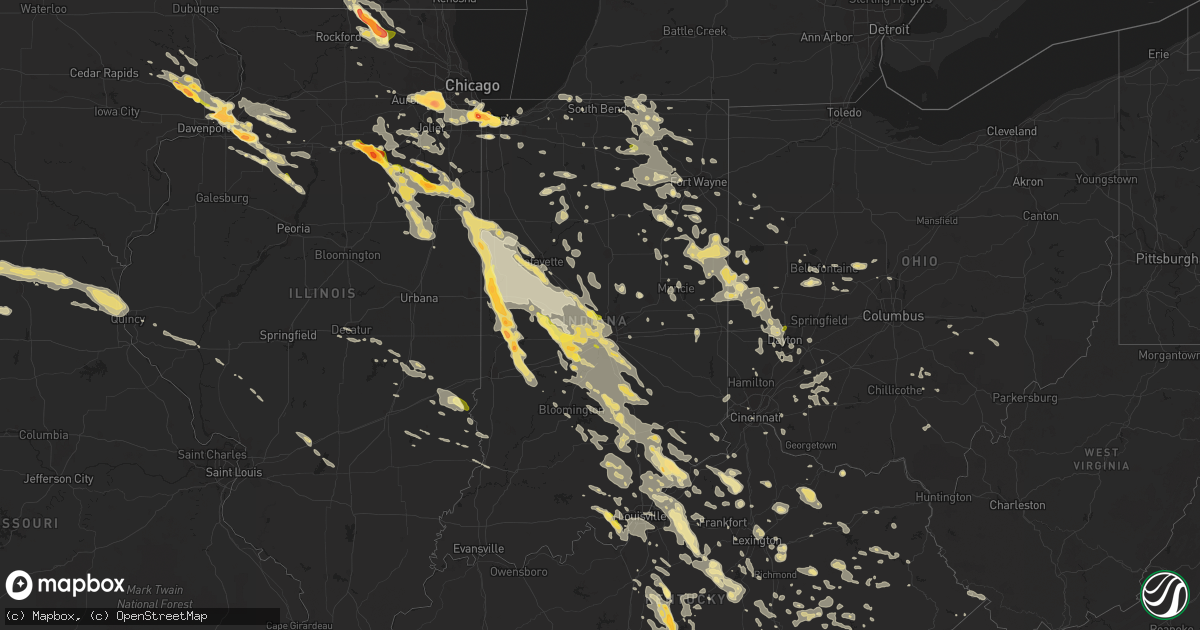
Hail Map in Indiana on July 13, 2015
Get this storm
July 13 map
$229
one time, instant access
Download today. No call, no setup
Keep the $229
Bought the map and want the full workflow? Apply the entire $229 to a subscription within 7 days. None of it is wasted.
Every map, not just this one
This buys you this map. Subscription and you get every map we run, in the markets you choose from a few cities to whole states to nationwide. Plus real-time alerts the moment a storm fires.
Contact data
Name, contact info, occupancy, even credit band for addresses in the footprint. You go from where it hit to who to call.
Become the source they trust
Unlimited branding weather history reports on demand. You already have the documented answer ready for the property owner, and you are the one who showed up with it.
Property data and RoofTrace estimates
Pull up any address you have got, its value and the exact code rules for that jurisdiction, straight from One Click Code. Then RoofTrace estimates the squares, pitch, and roof value, priced the way you price.
Storm reports in Indiana
Indiana
| Date | Description |
|---|---|
| 07/13/20153:01 PM CDT | A local report indicates 1.00 inch wind near 2 N CORYDON |
| 07/13/20151:25 PM CDT | Several large trees limbs down and large trees uprooted. One was across a power line. |
| 07/13/20151:20 PM CDT | Tree down in roadway charlestown pike and us 62 |
| 07/13/20151:09 PM CDT | Trees down in various locations in eastern clark county. |
| 07/13/20151:07 PM CDT | Trees and power lines down 102 sr 62 in new washington. |
| 07/13/201512:56 PM CDT | Tree across highway 62 near nabb. |
| 07/13/201512:42 PM CDT | Trees down countywide. |
| 07/13/201512:30 PM CDT | Trees and power lines downed near steak and shake on us route 50. |
| 07/13/201512:10 PM CDT | Numerous trees down along us route 31 between columbus and seymour. Us 31 impassible in a few spots. |
| 07/13/201512:09 PM CDT | Sign blown down near 38th and moller |
| 07/13/201512:05 PM CDT | Numerous trees down...one on garage. Time estimated from radar. |
| 07/13/201511:37 AM CDT | 10-12 inch limb down across w 8th street. Time estimated from radar. |
| 07/13/201511:30 AM CDT | Tree down across car at oak and sycamore streets. Time esitmated. |
| 07/13/201511:20 AM CDT | Tree limbs down on garden drive |
| 07/13/201511:19 AM CDT | A local report indicates 60 MPH wind near CAMBY |
| 07/13/201511:18 AM CDT | A local report indicates 65 MPH wind near FAIRLAND |
| 07/13/201511:12 AM CDT | Tree down near us31 and smith valley road. Time estimated from radar |
| 07/13/201511:07 AM CDT | Trees down near minnesota and meridian streets. Time estimated from radar. |
| 07/13/201510:56 AM CDT | Several large trees downed at 10th street near interstate 465. |
| 07/13/201510:52 AM CDT | Multiple trees snapped or uprooted |
| 07/13/201510:50 AM CDT | Multiple trees down near rockville and country club road. |
| 07/13/201510:45 AM CDT | Trees and power lines down |
| 07/13/201510:44 AM CDT | A few trees down at 86th street and zionsville road. |
| 07/13/201510:43 AM CDT | Large tree downed along county road 300s |
| 07/13/201510:42 AM CDT | A local report indicates 61 MPH wind near 7 W INDIANAPOLIS |
| 07/13/201510:42 AM CDT | Damage to pnc bank sign at intersection of ford and oak streets. |
| 07/13/201510:40 AM CDT | *** 1 inj *** driver injured by a falling tree. Reported by wthr. |
| 07/13/201510:40 AM CDT | Tree limbs downed |
| 07/13/201510:39 AM CDT | A local report indicates 60 MPH wind near BROWNSBURG |
| 07/13/201510:39 AM CDT | A local report indicates 60 MPH wind near 5 NW BROWNSBURG |
| 07/13/201510:36 AM CDT | Hague and 202nd street |
| 07/13/201510:10 AM CDT | Tree down north of frankfort |
| 07/13/20159:50 AM CDT | Concrete plant with roof blown off building. Bay doors were open at the time. Time esitmated. |
| 07/13/20159:50 AM CDT | Tree down - relayed by county ema. |
| 07/13/20158:55 AM CDT | Large tree limb down |
| 07/13/20154:48 AM CDT | Tree limbs fell on vehicle and fence |
| 07/13/20152:45 AM CDT | Multiple trees down in the county. |
| 07/13/20151:36 AM CDT | Widespread flooding along wiht multiple trees and powerlines down. |
| 07/13/20151:20 AM CDT | Indiana dhs called reporting trees down...power lines down and damage to homes from around 10th and tibbs street to meridian street and thompson road. |
| 07/13/20151:20 AM CDT | A few tree branches down up to 1.5 inches thick and several feet thick |
| 07/13/20151:20 AM CDT | Street flooding one foot deepat winston and 22nd street. Utility lines down on 22nd and fisher blocking road. |
| 07/13/20151:04 AM CDT | Numerous trees down shortly before and after this time...several on vehicles. Significant tree damage reported at crawfordsville and lynhurst. Damage also at gerrard an |
| 07/13/201512:26 AM CDT | Barns destroyed. |
| 07/13/201512:10 AM CDT | Multiple reports of tree limbs down around speedway. Time estimated from radar. |
| 07/12/201511:15 PM CDT | Two trees down on route 262 |
| 07/12/201510:23 PM CDT | A local report indicates 1.00 inch wind near ZIONSVILLE |
| 07/12/201510:00 PM CDT | Located at central avenue |
| 07/12/20159:56 PM CDT | A local report indicates 58 MPH wind near COLUMBUS |
| 07/12/20159:53 PM CDT | Tree on top of house...believed to be a different house than previous report of same in columbus. Time estimated from earlier report. Report relayed by media. |
| 07/12/20159:35 PM CDT | Heard 3 trees fall in the woods off of lanam ridge road. Estimated wind of 50 to 60 mph. |
| 07/12/20159:22 PM CDT | A local report indicates 60 MPH wind near MARTINSVILLE |
| 07/12/20159:05 PM CDT | Large tree branches down and 1 tree in the aboite area... Near homestead high school |
| 07/12/20159:04 PM CDT | A local report indicates 1.00 inch wind near 7 SW INDIANAPOLIS |
| 07/12/20159:02 PM CDT | Power lines and numerous trees down. Time estimated from radar and general recollection of time by spotter. |
| 07/12/20159:00 PM CDT | Small tree limbs down...less than 2 inches in diameter |
| 07/12/20159:00 PM CDT | A local report indicates 1.00 inch wind near MONROVIA |
| 07/12/20158:55 PM CDT | Report of a tree down. No additional information on size/health of the tree. |
| 07/12/20158:50 PM CDT | Numerous trees down southeast of portland to the county line. Several blocking roads. Time estimated from radar. |
| 07/12/20158:47 PM CDT | Large tree down across cr-44 between cr 37 and cr 33. |
| 07/12/20158:45 PM CDT | Estimated of 1 to 1.5-inch hail on cartersburg road |
| 07/12/20158:42 PM CDT | A local report indicates 60 MPH wind near DANVILLE |
| 07/12/20158:31 PM CDT | North side of town. Accompanied with estimated 45 mph wind. |
| 07/12/20158:30 PM CDT | Numerous trees and power poles down. Time estimated. |
| 07/12/20158:26 PM CDT | Report of a tree down near cromwell. No information on size/health. |
| 07/12/20158:25 PM CDT | Nws survey revealed ef1 damage with 90 mph winds in northeast tip of heritage lake area. Tornado damage embedded in a broad area of downburst damage across northeast pu |
| 07/12/20158:24 PM CDT | Trees down |
| 07/12/20158:24 PM CDT | Tree limbs or trees down. Reported via twitter |
| 07/12/20158:15 PM CDT | Ef0 based on trained spotter siting in cornfields |
| 07/12/20158:00 PM CDT | 3900 block of hohman ave. |
| 07/12/20157:59 PM CDT | Short lived ef-0 path length 1/10 mile and 50 yards wide. Was on the ground for one minute. Was spotted by a storm spotter. Occurred in an open area with no damage. Tim |
| 07/12/20157:55 PM CDT | A local report indicates 1.00 inch wind near 1 NW TIPPECANOE LAKE |
| 07/12/20157:55 PM CDT | A local report indicates 1.75 inch wind near GARY |
| 07/12/20157:50 PM CDT | A local report indicates 1.75 inch wind near EAST CHICAGO |
| 07/12/20157:45 PM CDT | Indianapolis blvd and michigan ave. |
All States Impacted by Hail Map on July 13, 2015
Cities Impacted by Hail Map on July 13, 2015
- Corydon, IN
- McClellanville, SC
- Lineville, IA
- Davis City, IA
- Blythedale, MO
- Templeton, IN
- Oxford, IN
- Holcomb, KS
- Garden City, KS
- Shipshewana, IN
- Millersburg, IN
- Middlebury, IN
- Topeka, IN
- Goshen, IN
- Woodruff, SC
- Delphi, IN
- Knapp, WI
- Glenwood City, WI
- Wilson, WI
- Woodville, WI
- Seneca, IL
- Marseilles, IL
- Troy, NC
- Grand Ridge, IL
- Ottawa, IL
- Vallonia, IN
- Scottsburg, IN
- Salem, IN
- Munster, IN
- Chicago Heights, IL
- Calumet City, IL
- Riverdale, IL
- Gary, IN
- Hammond, IN
- Blue Island, IL
- Hobart, IN
- Highland, IN
- Dolton, IL
- East Chicago, IN
- Markham, IL
- Chicago, IL
- Lansing, IL
- Lake Station, IN
- Griffith, IN
- Harvey, IL
- Whiting, IN
- South Holland, IL
- Thornton, IL
- Turon, KS
- Arlington, KS
- Osseo, WI
- Alma Center, WI
- Hixton, WI
- Prophetstown, IL
- New Bedford, IL
- Tampico, IL
- Walnut, IL
- Lyons, KS
- Nickerson, KS
- Little River, KS
- Inman, KS
- Hutchinson, KS
- Sterling, KS
- Caledonia, IL
- Clinton, WI
- Marengo, IL
- Harvard, IL
- Garden Prairie, IL
- South Beloit, IL
- Poplar Grove, IL
- Capron, IL
- Lafayette, IN
- Campbellsville, KY
- Fort Atkinson, WI
- Cambridge, WI
- Edgerton, WI
- Wheatland, IA
- Grand Mound, IA
- Lowden, IA
- Donahue, IA
- Long Grove, IA
- Calamus, IA
- Petroleum, IN
- Bluffton, IN
- Poneto, IN
- Keystone, IN
- Union City, OH
- Portland, IN
- Union City, IN
- New Weston, OH
- Ansonia, OH
- Lynn, IN
- Winchester, IN
- Fort Recovery, OH
- Ridgeville, IN
- Greenville, OH
- Amery, WI
- Balsam Lake, WI
- South Whitley, IN
- Columbia City, IN
- Larwill, IN
- Tinley Park, IL
- Orland Park, IL
- Mcpherson, KS
- St John, KS
- Great Bend, KS
- Hudson, KS
- Ellinwood, KS
- Schoolcraft, MI
- Cedar Grove, NC
- Westby, WI
- Cashton, WI
- Roberts, IL
- Buckley, IL
- Thawville, IL
- Versailles, KY
- Nicholasville, KY
- Creola, OH
- Mooresburg, TN
- Thorn Hill, TN
- Lancaster, SC
- Catawba, SC
- Ravenna, KY
- Clay City, KY
- Lakin, KS
- Vanceburg, KY
- Cimarron, KS
- Huntington, IN
- Williamsport, IN
- West Lebanon, IN
- Covington, IN
- Veedersburg, IN
- Kingman, IN
- Sparta, WI
- Rockland, WI
- Bangor, WI
- West Salem, WI
- Allerton, IA
- Corydon, IA
- New Era, MI
- Montague, MI
- Cedar Lake, IN
- Crown Point, IN
- Saint John, IN
- Schererville, IN
- Greensburg, KY
- New London, WI
- Camden, IN
- Newton, IL
- Ingraham, IL
- Mattoon, IL
- Charleston, IL
- Humboldt, IL
- Whitehall, WI
- Taylor, WI
- Blair, WI
- Strawn, IL
- Chatsworth, IL
- Spartanburg, SC
- Chesnee, SC
- Brooklyn, MI
- Onsted, MI
- Aurora, IL
- Willowbrook, IL
- Downers Grove, IL
- Bolingbrook, IL
- Lemont, IL
- Darien, IL
- Naperville, IL
- Woodridge, IL
- Lisle, IL
- Leslie, GA
- Geneseo, IL
- Buckner, KY
- La Grange, KY
- Paris, KY
- Celina, TN
- Hope, KS
- Gypsum, KS
- Sneedville, TN
- Blackwater, VA
- Kyles Ford, TN
- Jonesville, VA
- Lima, OH
- Leesburg, IN
- Milton, KY
- Bedford, KY
- Hanover, IN
- Herscher, IL
- Paynesville, WV
- Edinburgh, IN
- Columbus, IN
- Edmonton, KY
- Burkesville, KY
- Le Claire, IA
- Port Byron, IL
- Kirksville, MO
- Brashear, MO
- Novinger, MO
- Greentop, MO
- Queen City, MO
- Wellington, MO
- Germanton, NC
- Walnut Cove, NC
- Fort Mill, SC
- Rock Hill, SC
- Portage, WI
- Poynette, WI
- Winnsboro, SC
- Ridgeway, SC
- Dodge, WI
- La Crosse, WI
- Trempealeau, WI
- Viola, WI
- Onalaska, WI
- Holmen, WI
- Coon Valley, WI
- Fountain City, WI
- La Farge, WI
- Winona, MN
- Galesville, WI
- Arcadia, WI
- Richmond, KY
- Winchester, KY
- Lexington, KY
- Merrillville, IN
- Newton, KS
- North Newton, KS
- Bucklin, KS
- Ivanhoe, NC
- Harrells, NC
- Humboldt, NE
- Dunnellon, FL
- Great Falls, SC
- Galva, KS
- Rossville, IN
- Frankfort, IN
- Cutler, IN
- Lawrenceburg, KY
- Alden, KS
- Whitmire, SC
- Brooklyn, WI
- Marysville, OH
- Raymond, OH
- Richwood, OH
- Romeoville, IL
- Crest Hill, IL
- Lockport, IL
- Irvine, KY
- Winamac, IN
- Monterey, IN
- Martinsville, IN
- Mooers Forks, NY
- Commiskey, IN
- Paris Crossing, IN
- Atkinson, IL
- Cambridge, IL
- Shelbyville, KY
- Bagdad, KY
- Farmland, IN
- Bloomington, IN
- Camden, SC
- Lugoff, SC
- Elizabethtown, KY
- Valparaiso, IN
- Stockland, IL
- Bloomingdale, IN
- Kentland, IN
- Bridgeton, IN
- Knightsville, IN
- Centerpoint, IN
- Sheldon, IL
- Brazil, IN
- Wellington, IL
- Reelsville, IN
- Earl Park, IN
- Fowler, IN
- Harmony, IN
- Watseka, IL
- Rockville, IN
- Milford, IL
- Rosedale, IN
- Hoopeston, IL
- Ambia, IN
- Montezuma, IN
- Marshall, IN
- Carbon, IN
- Elmer, MO
- Ethel, MO
- New Boston, MO
- Cochrane, WI
- Fulton, MI
- Mendon, MI
- Oak Grove, MO
- Wyanet, IL
- Ottawa, KS
- Lorraine, KS
- Geneseo, KS
- Cambridge City, IN
- Youngstown, FL
- Urbana, OH
- De Graff, OH
- Merrimac, WI
- Stamping Ground, KY
- Lexington, NC
- Ravenwood, MO
- Maryville, MO
- Bethany, MO
- Sheridan, MO
- Ridgeway, MO
- Denver, MO
- Gentry, MO
- Albany, MO
- New Hampton, MO
- Worth, MO
- Martinsville, MO
- Burlington Junction, MO
- Hopkins, MO
- Pickering, MO
- Tarkio, MO
- Parnell, MO
- Eagleville, MO
- Baraboo, WI
- Rio, WI
- Paola, KS
- Fontana, KS
- Osawatomie, KS
- La Cygne, KS
- Waupaca, WI
- Hazel Crest, IL
- Midlothian, IL
- Oak Forest, IL
- Country Club Hills, IL
- Wilmington, NC
- Castle Hayne, NC
- Seymour, WI
- Rochester, IN
- Francesville, IN
- Asheboro, NC
- Sutherlin, VA
- Ringgold, VA
- Arlington, WI
- Harrodsburg, KY
- Krypton, KY
- Busy, KY
- Pembroke, NC
- Lumberton, NC
- Elon, NC
- Milton, NC
- Providence, NC
- Yanceyville, NC
- Mebane, NC
- Blanch, NC
- Burlington, NC
- Mount Vernon, KY
- Berea, KY
- Tyner, KY
- Vincent, KY
- Wellington, KY
- Campton, KY
- Pennville, IN
- Kewanee, IL
- Monroeville, IN
- Nineveh, IN
- Nashville, IN
- Moore Haven, FL
- Vienna, GA
- Muskegon, MI
- Twin Lake, MI
- Clarence, IA
- Spickard, MO
- Galt, MO
- Humphreys, MO
- Princeton, MO
- Milan, MO
- Mount Pleasant, SC
- Awendaw, SC
- Adrian, GA
- Utica, IL
- Syracuse, IN
- Ligonier, IN
- Delmar, IA
- Oxford Junction, IA
- Lost Nation, IA
- De Witt, IA
- Morgantown, IN
- Sparland, IL
- Russell Springs, KY
- Dunnville, KY
- Hanston, KS
- Larned, KS
- Green Bay, WI
- Bristol, IN
- Luck, WI
- Centuria, WI
- Cushing, WI
- Milltown, WI
- Monrovia, IN
- New Hope, KY
- Raywick, KY
- La Grange, IL
- Berwyn, IL
- Arcanum, OH
- Orlando, KY
- Crab Orchard, KY
- Brodhead, KY
- Strum, WI
- Fairchild, WI
- Jackson, KY
- Salyersville, KY
- Rousseau, KY
- Ford, KS
- Wilmington, IL
- Bonfield, IL
- Essex, IL
- Braceville, IL
- Braidwood, IL
- Ellsworth, KS
- Kanopolis, KS
- Pawnee Rock, KS
- Decatur, MI
- Lawrence, MI
- Paw Paw, MI
- Hartford, MI
- Wilmington, OH
- New Vienna, OH
- Whitehall, MI
- Kankakee, IL
- Overbrook, KS
- Carbondale, KS
- Martinsville, IL
- West Union, IL
- West York, IL
- Leland, NC
- Whitewater, KS
- Elbing, KS
- El Dorado, KS
- Cassoday, KS
- Burns, KS
- Potwin, KS
- Robinson, IL
- Hillsboro, OH
- Midland, OH
- Lynchburg, OH
- Martinsville, OH
- Englewood, OH
- Abbyville, KS
- Concord, VA
- North Troy, VT
- Newport Center, VT
- Newport, VT
- Verona, IL
- Salamonia, IN
- Dayton, OH
- Ash, NC
- Ocean Isle Beach, NC
- Scottville, MI
- Ludington, MI
- Neponset, IL
- Eutawville, SC
- Viroqua, WI
- Readstown, WI
- Smithville, GA
- De Soto, GA
- Elizabethton, TN
- Hampton, TN
- Butler, TN
- Dunkirk, IN
- McKee, KY
- Annville, KY
- Booneville, KY
- Danville, VA
- Claxton, GA
- Cobbtown, GA
- Collins, GA
- Kewaunee, WI
- Algoma, WI
- Casco, WI
- Zanesfield, OH
- Bellefontaine, OH
- Galien, MI
- New Buffalo, MI
- Rolling Prairie, IN
- La Porte, IN
- New Carlisle, IN
- Three Oaks, MI
- Cynthiana, KY
- Albion, IN
- Kimmell, IN
- Beattyville, KY
- Cainsville, MO
- Madison, WI
- Waunakee, WI
- Newaygo, MI
- Somerset, OH
- Seymour, IN
- Sullivan, IL
- Douglas, AZ
- Tiskilwa, IL
- Princeton, IL
- Shiocton, WI
- Black River Falls, WI
- Mondovi, WI
- Durand, WI
- Melrose, WI
- Menomonie, WI
- Fall Creek, WI
- Eau Claire, WI
- Eleva, WI
- Janesville, WI
- Kouts, IN
- Saint Croix Falls, WI
- Roanoke, IN
- Yoder, IN
- Fort Wayne, IN
- Warsaw, IN
- Milford, IN
- Hyde Park, VT
- Morrisville, VT
- Johnson City, TN
- Beverly, KS
- Manteno, IL
- Bourbonnais, IL
- Buckhorn, KY
- Gays Creek, KY
- Union, IL
- Champlain, NY
- West Chazy, NY
- Chazy, NY
- Longwood, NC
- Sunset Beach, NC
- Clayton, OH
- Brookville, OH
- Muncie, IN
- Bluff City, TN
- Egg Harbor, WI
- Modoc, IN
- Avon, IN
- Darlington, SC
- Inman, SC
- Bolton, NC
- Procious, WV
- Crestwood, KY
- Lone Rock, WI
- Avoca, WI
- Spring Green, WI
- Ridgeway, WI
- Arena, WI
- Richland Center, WI
- Dodgeville, WI
- Sister Bay, WI
- Mercer, MO
- Berne, IN
- Montpelier, IN
- Hartford City, IN
- Geneva, IN
- Bryant, IN
- New Middletown, IN
- Elizabeth, IN
- New London, NC
- Albemarle, NC
- Elkhart, IN
- Casa Blanca, NM
- Ingalls, KS
- Jetmore, KS
- Belvidere, IL
- Huntertown, IN
- Churubusco, IN
- Laotto, IN
- Green City, MO
- Rutledge, MO
- Worthington, MO
- Memphis, MO
- Green Castle, MO
- Baring, MO
- Pollock, MO
- Edina, MO
- Knox City, MO
- Unionville, MO
- Downing, MO
- Lewistown, MO
- Canton, MO
- La Grange, MO
- Monticello, MO
- Willisburg, KY
- Wausau, WI
- Merrill, WI
- Antigo, WI
- Moncks Corner, SC
- Milwaukee, WI
- Montezuma, KS
- Battle Creek, MI
- Ceresco, MI
- Burgaw, NC
- Willard, NC
- Seymour, IA
- Mattoon, WI
- New Franken, WI
- Boiling Springs, SC
- Centreville, MI
- Three Rivers, MI
- Sturgis, MI
- Petersburg, VA
- Campobello, SC
- Wellford, SC
- Moore, SC
- Long Creek, OR
- Anderson, IN
- Saint Henry, OH
- Portage, IN
- Leonidas, MI
- Vicksburg, MI
- Columbia, KY
- Marcellus, MI
- Browns Summit, NC
- Gibsonville, NC
- Vancleve, KY
- Frenchburg, KY
- Slade, KY
- East Bend, NC
- Bourbon, IN
- Plymouth, IN
- Grant, MI
- Ravenna, MI
- Nancy, KY
- Gardner, IL
- Buckingham, IL
- Reddick, IL
- Chebanse, IL
- North Vernon, IN
- Allons, TN
- Hilham, TN
- Bardstown, KY
- Coxs Creek, KY
- Birnamwood, WI
- Aniwa, WI
- Bloomfield, KY
- Austin, IN
- Freetown, IN
- Eidson, TN
- New Liberty, KY
- Owenton, KY
- Corinth, KY
- Simpsonville, KY
- Waddy, KY
- Mount Eden, KY
- Louisville, KY
- Fisherville, KY
- Finchville, KY
- Chaplin, KY
- Taylorsville, KY
- Otisco, IN
- Underwood, IN
- Marysville, IN
- Glencoe, KY
- Warsaw, KY
- Wild Rose, WI
- Pine River, WI
- Redgranite, WI
- Fayetteville, NC
- Westmont, IL
- New Paris, OH
- Mayesville, SC
- Rocky Point, NC
- Frankfort, KY
- Supply, NC
- Whitestown, IN
- Zionsville, IN
- Richmond Hill, GA
- Saltville, VA
- Somerset, KY
- Rockford, MI
- Belmont, MI
- Ada, MI
- Lake Placid, FL
- Spencer, IN
- Burnettsville, IN
- Star City, IN
- Royal Center, IN
- Idaville, IN
- Monticello, IN
- Logansport, IN
- Pageland, SC
- Marshville, NC
- Blountville, TN
- Kingsport, TN
- West Lafayette, IN
- New Ross, IN
- Crawfordsville, IN
- Hillsboro, IN
- Colfax, IN
- Romney, IN
- Thorntown, IN
- New Richmond, IN
- Pine Village, IN
- Attica, IN
- Linden, IN
- Wingate, IN
- Lebanon, IN
- Darlington, IN
- Mellott, IN
- Ladoga, IN
- Boswell, IN
- Otterbein, IN
- Westpoint, IN
- Waynetown, IN
- Newtown, IN
- Jamestown, IN
- Mayview, MO
- Ossian, IN
- Lynchburg, VA
- Wheeler, WI
- Donovan, IL
- Clifton, IL
- Papineau, IL
- Saint Anne, IL
- Beaverville, IL
- Martinton, IL
- Cabery, IL
- Hardinsburg, IN
- Fredericksburg, IN
- Chase, KS
- Star, NC
- Annawan, IL
- Grantsburg, WI
- Piper City, IL
- Blythewood, SC
- East Moline, IL
- Rapids City, IL
- Bettendorf, IA
- Cordova, IL
- Hillsdale, IL
- Eldridge, IA
- Davenport, IA
- Princeton, IA
- McCausland, IA
- Tollesboro, KY
- Plevna, KS
- Odell, IL
- Hodgenville, KY
- Buda, IL
- Bradford, IL
- Cecil, WI
- South Bend, IN
- Green Sea, SC
- Bladenboro, NC
- Roodhouse, IL
- Winchester, IL
- Cullom, IL
- Saunemin, IL
- Shepherdsville, KY
- Coatesville, IN
- Stilesville, IN
- Mooresville, IN
- Clayton, IN
- Plainfield, IN
- Danville, IN
- Ramsey, IN
- Copeland, KS
- Colon, MI
- Allegan, MI
- Hopkins, MI
- Mount Olive, NC
- Decatur, IL
- Cassopolis, MI
- Jones, MI
- Vandalia, MI
- Clio, SC
- Bradford, OH
- Clayhole, KY
- Lost Creek, KY
- Borden, IN
- Pekin, IN
- Emington, IL
- Covington, OH
- Baileys Harbor, WI
- Akron, IN
- Clarks Hill, IN
- Ramseur, NC
- Franklinville, NC
- Staley, NC
- Dowagiac, MI
- Jackson, OH
- Fillmore, IN
- Cloverdale, IN
- Quincy, IN
- Cottage Grove, WI
- Clarendon Hills, IL
- Alton, VA
- Brownstown, IN
- Newark, MO
- La Belle, MO
- Ewing, MO
- Ohio City, OH
- Van Wert, OH
- Matewan, WV
- Wharncliffe, WV
- Deerfield, KS
- Dillon, SC
- Wyoming, IL
- Soldiers Grove, WI
- Yale, IL
- Oblong, IL
- Medaryville, IN
- North Judson, IN
- Gravel Switch, KY
- Lebanon, KY
- Carlinville, IL
- Hettick, IL
- Kewanna, IN
- Charlestown, IN
- North Charleston, SC
- Ladson, SC
- Scott City, KS
- Laurelville, OH
- Kingston, OH
- Winigan, MO
- Middle Point, OH
- Hampton, IL
- Colona, IL
- Camanche, IA
- Kingman, KS
- Buffalo, KY
- New Haven, KY
- Mount Sherman, KY
- Summersville, KY
- Milltown, IN
- Depauw, IN
- Georgetown, IN
- Brooks, KY
- Laconia, IN
- New Salisbury, IN
- Crandall, IN
- Fairdale, KY
- Lanesville, IN
- New Albany, IN
- Kirklin, IN
- Kempton, IN
- Sheridan, IN
- Michigantown, IN
- Marion, IN
- Van Buren, IN
- Roachdale, IN
- Bainbridge, IN
- Amo, IN
- North Salem, IN
- Randolph, VA
- Brookneal, VA
- Charlotte Court House, VA
- Phenix, VA
- Saxe, VA
- Sanderson, FL
- Arcadia, FL
- Cicero, IN
- Arcadia, IN
- Atlanta, IN
- Waukesha, WI
- Delafield, WI
- Nashotah, WI
- Hartland, WI
- Pewaukee, WI
- Bluffs, IL
- Prestonsburg, KY
- Whiteville, NC
- Windom, KS
- Chesterton, IN
- Penhook, VA
- Americus, GA
- Red House, VA
- Longs, SC
- Loris, SC
- Olive Hill, KY
- Morehead, KY
- Mooers, NY
- Altona, NY
- Moorefield, KY
- Mayslick, KY
- Flemingsburg, KY
- Mount Olivet, KY
- Ewing, KY
- Carlisle, KY
- Greenville, IL
- Yorkville, IL
- Dry Ridge, KY
- Jonesville, KY
- McCarr, KY
- Stopover, KY
- Freeburn, KY
- Majestic, KY
- Macon, IL
- Dalton City, IL
- Dwight, IL
- Mazon, IL
- Kempton, IL
- Ransom, IL
- Campus, IL
- Kinsman, IL
- Plainfield, WI
- Almond, WI
- Plover, WI
- Bancroft, WI
- Wisconsin Rapids, WI
- Amherst, WI
- Bellbrook, OH
- Spring Valley, OH
- Xenia, OH
- Miamisburg, OH
- Waynesville, OH
- Springboro, OH
- Berryton, KS
- McBee, SC
- Dupont, IN
- Madison, IN
- Beloit, WI
- Woodstock, IL
- Gate City, VA
- Church Hill, TN
- Wingate, NC
- Monroe, NC
- Daleville, AL
- Johnson, NE
- Tecumseh, NE
- Lawrence, NE
- Shady Valley, TN
- Metter, GA
- Register, GA
- Sorento, IL
- Welch, WV
- Anawalt, WV
- Mozelle, KY
- Warbranch, KY
- Cubero, NM
- Pueblo Of Acoma, NM
- Rogersville, TN
- Bringhurst, IN
- Flora, IN
- Homewood, IL
- Quincy, IL
- Liberty Hill, SC
- Hazel Green, KY
- Clarkton, NC
- Florence, SC
- Wisconsin Dells, WI
- Berry, KY
- Needham, IN
- Stinnett, KY
- Hyden, KY
- Gays, IL
- Elburn, IL
- Sugar Grove, IL
- Monmouth, IA
- Wyoming, IA
- Campbellsburg, IN
- Bowling Green, IN
- Poland, IN
- Currie, NC
- Churubusco, NY
- Sublette, KS
- Claypool, IN
- Pierceton, IN
- Jackson Center, OH
- Maplewood, OH
- Stanford, KY
- Junction City, KY
- Salvisa, KY
- Pewee Valley, KY
- Mackville, KY
- Danville, KY
- Perryville, KY
- Lancaster, KY
- Brookville, KS
- Upland, IN
- Baldwin City, KS
- Lawrence, KS
- Wakarusa, KS
- Yorktown, IN
- Daleville, IN
- La Salle, IL
- Harts, WV
- Matfield Green, KS
- Sandgap, KY
- Gladstone, VA
- Lamar, SC
- Independence, WI
- Sheffield, IL
- Lucerne, MO
- White Cloud, MI
- West Liberty, KY
- Buhler, KS
- Goshen, OH
- Pleasant Plain, OH
- New Glarus, WI
- Belleville, WI
- Piney Flats, TN
- Niles, MI
- Buchanan, MI
- Greeneville, TN
- Parrottsville, TN
- Crete, IL
- Dyer, IN
- Wilmore, KY
- Oneida, WI
- Black Creek, WI
- Lexington, NE
- New Lenox, IL
- Mokena, IL
- Homer Glen, IL
- Beech Grove, IN
- Indianapolis, IN
- Union, MI
- White Pigeon, MI
- Fedscreek, KY
- Steele, KY
- Topeka, KS
- Sumner, IL
- Tomah, WI
- Elwood, IL
- Morris, IL
- Newark, IL
- Minooka, IL
- Shorewood, IL
- Joliet, IL
- Channahon, IL
- Manhattan, IL
- Palestine, IL
- Carlisle, IN
- Harrison, OH
- West Harrison, IN
- Lawrenceburg, IN
- Nunica, MI
- Coopersville, MI
- Fruitport, MI
- Pierceville, KS
- Kent City, MI
- Harris, MO
- Ursa, IL
- Newtown, MO
- Durham, MO
- Hurdland, MO
- Maywood, MO
- Williamstown, MO
- Mill Creek, IN
- Hinckley, IL
- Hampstead, NC
- Casey, IL
- Blanchester, OH
- Clarksville, OH
- Delbarton, WV
- Dodge City, KS
- Alto, MI
- Randleman, NC
- Climax, NC
- Deer Grove, IL
- Appomattox, VA
- Waynesburg, KY
- Crivitz, WI
- Elgin, SC
- Tabor City, NC
- Cherry Valley, IL
- Covington, KY
- Bedford, VA
- Knifley, KY
- Greenfield, IL
- Skidmore, MO
- Fairfax, MO
- Ellettsville, IN
- Gosport, IN
- Clifford, IN
- Hope, IN
- Taylorsville, IN
- Rossburg, OH
- Verona, KY
- London, KY
- Floyds Knobs, IN
- Montgomery Center, VT
- Wellsville, KS
- Rantoul, KS
- Grand Rapids, MI
- Plainwell, MI
- Martin, MI
- Otsego, MI
- Markle, IN
- Warren, IN
- Barneveld, WI
- Mount Horeb, WI
- Hillsboro, WI
- Genoa, WI
- Hillpoint, WI
- Blue Mounds, WI
- Gradyville, KY
- Magnolia, KY
- Breeding, KY
- Tompkinsville, KY
- Startex, SC
- Duncan, SC
- Gas City, IN
- Jonesboro, IN
- Fairmount, IN
- Loda, IL
- Radnor, OH
- Tazewell, TN
- Ludlow Falls, OH
- Redkey, IN
- Pleasant Hill, OH
- Laura, OH
- Pitsburg, OH
- West Milton, OH
- Phillipsburg, OH
- Tipp City, OH
- Vandalia, OH
- Gettysburg, OH
- Versailles, OH
- Salt Lick, KY
- Ness City, KS
- Sadieville, KY
- Warrensburg, MO
- Charlotte, NC
- Waxhaw, NC
- Posen, IL
- Columbus, WI
- Lagrange, IN
- Howe, IN
- Pendleton, IN
- Wilkinson, IN
- Greenfield, IN
- Humeston, IA
- Keyesport, IL
- Monroe, VA
- Madison Heights, VA
- Ezel, KY
- Canaan, IN
- Butlerville, IN
- Nabb, IN
- Lexington, IN
- Deputy, IN
- Deforest, WI
- Hutsonville, IL
- Lizton, IN
- Norman, IN
- Medora, IN
- Bedford, IN
- Heltonville, IN
- Greenwood, IN
- Franklin, IN
- Whiteland, IN
- Leon, IA
- Forest, VA
- Oshkosh, WI
- Amelia, OH
- New Richmond, OH
- Lerna, IL
- Caledonia, MI
- Fountain, FL
- Syracuse, KS
- Kendallville, IN
- Leo, IN
- Auburn, IN
- Pendleton, KY
- Bethlehem, IN
- New Washington, IN
- Buckingham, VA
- Blenheim, SC
- Bennettsville, SC
- Cedar Bluff, VA
- Honaker, VA
- Sandoval, IL
- Carlyle, IL
- Parker, KS
- Lodi, WI
- Sauk City, WI
- Dane, WI
- Cross Plains, WI
- Jamestown, OH
- Port William, OH
- Clear Lake, WI
- Prospect, KY
- Goshen, KY
- Uniondale, IN
- Craigville, IN
- Dover, KY
- Hamlin, WV
- Woodstock, OH
- Milford Center, OH
- Bradfordsville, KY
- New Castle, KY
- Pleasureville, KY
- Campbellsburg, KY
- Sulphur, KY
- La Fontaine, IN
- Wheeler, IL
- Dillsboro, IN
- Bennington, IN
- Rising Sun, IN
- Georgetown, KY
- Maquoketa, IA
- Baldwin, IA
- Greenup, IL
- Arrington, VA
- Lynchburg, SC
- Lexington, MO
- Odessa, MO
- Fremont, MI
- Holton, MI
- Rosewood, OH
- Saint Paris, OH
- Conover, OH
- West Liberty, OH
- Eubank, KY
- Peru, IN
- Liberty Center, IN
- Wright, KS
- Clarendon, NC
- Nathalie, VA
- Denton, NC
- Nichols, SC
- Lamoni, IA
- Kellerton, IA
- Cable, OH
- North Lewisburg, OH
- Pineville, NC
- Cross, SC
- Suamico, WI
- Luxemburg, WI
- Little Suamico, WI
- Galva, IL
- Pleasant Valley, IA
- Erie, IL
- Chillicothe, IL
- Toulon, IL
- Athelstane, WI
- Belding, MI
- Saranac, MI
- Lowell, MI
- Alexandria, KY
- Moundridge, KS
- Rustburg, VA
- Hazard, KY
- Rowdy, KY
- Harbert, MI
- Sawyer, MI
- Bridgman, MI
- Trinity, NC
- Sophia, NC
- High Point, NC
- Monee, IL
- Frankfort, IL
- Huger, SC
- Sandwich, IL
- Matthews, IN
- Silver City, IA
- Mount Sterling, KY
- Delton, MI
- Pratt, KS
- Altura, MN
- Alma, WI
- Neoga, IL
- Palmyra, IN
- Greenville, IN
- Griggsville, IL
- Liberty, IL
- Barry, IL
- Baylis, IL
- Vevay, IN
- Abingdon, VA
- Marion, VA
- Myrtle Beach, SC
- Camp Douglas, WI
- Charleston, SC
- Boyceville, WI
- Richland, MI
- Hickory Corners, MI
- Constantine, MI
- Orleans, MI
- Bishopville, SC
- Webbville, KY
- Grayson, KY
- Sandy Hook, KY
- Mentone, IN
- Lucerne, IN
- Wooton, KY
- Reidsville, NC
- Oswego, IL
- Union, SC
- Enoree, SC
- Olin, IA
- Elkfork, KY
- Flatgap, KY
- Piqua, OH
- Bethune, SC
- Clover, VA
- Drakes Branch, VA
- Gladys, VA
- Decatur, IA
- Little Rock, SC
- Windsor, KY
- Bangor, MI
- Covert, MI
- Milton, IN
- Dunlow, WV
- Partridge, KS
- Pittsboro, IN
- Boggstown, IN
- Brooklyn, IN
- Shelbyville, IN
- Brownsburg, IN
- Lockport, KY
- Roanoke, VA
- Muir, MI
- Ionia, MI
- Fenwick, MI
- Williamsburg, OH
- Mount Orab, OH
- Ostrander, OH
- Atkinson, NC
- Lane, KS
- Pomona, KS
- Boston, KY
- Lebanon Junction, KY
- Hartsville, SC
- Manchester, KY
- Brookfield, WI
- Elm Grove, WI
- Westfield, IL
- Omro, WI
- Greensboro, NC
- East Liberty, OH
- Kirkland, IL
- Clare, IL
- Hesperia, MI
- Sanders, KY
- Sparta, KY
- York, SC
- Wabash, IN
- Avalon, WI
- Darien, WI
- Sharon, WI
- Walworth, WI
- Swainsboro, GA
- Soperton, GA
- Kite, GA
- North Manchester, IN
- Sheridan, IL
- Millington, IL
- Serena, IL
- Pounding Mill, VA
- Jonesborough, TN
- Dillwyn, VA
- Howardsville, VA
- Hallsboro, NC
- North Myrtle Beach, SC
- Calabash, NC
- Shallotte, NC
- Delco, NC
- Lake Waccamaw, NC
- Bolivia, NC
- Little River, SC
- Nakina, NC
- Winnabow, NC
- Marengo, IN
- Whitley City, KY
- Carrollton, KY
- Turners Station, KY
- Corbin, KY
- Oneida, KY
- Ricetown, KY
- Mistletoe, KY
- Rothbury, MI
- Germantown, OH
- Arthur, IL
- Corning, OH
- Colfax, WI
- New Palestine, IN
- South Bloomingville, OH
- Goose Creek, SC
- Hope Mills, NC
- Hamilton, OH
- Paoli, IN
- Thornville, OH
- Scott, OH
- Yellow Springs, OH
- Lick Creek, KY
- Harrogate, TN
- Wonewoc, WI
- Delavan, WI
- Sheboygan, WI
- Byron Center, MI
- Owingsville, KY
- Onslow, IA
- Wapakoneta, OH
- Spencerville, OH
- Wawaka, IN
- New Paris, IN
- North Webster, IN
- Winona Lake, IN
- Silver Lake, IN
- Nappanee, IN
- Cromwell, IN
- Edwardsburg, MI
- Avilla, IN
- Etna Green, IN
- New Castle, IN
- Hagerstown, IN
- Mooreland, IN
- Hubbardston, MI
- Carson City, MI
- Delaware, OH
- Norwalk, WI
- Osco, IL
- Liberty, NC
- Andrews, IN
- Lagro, IN
- Urbana, IN
- Stanton, KY
- Jeffersonville, IN
- Masonic Home, KY
- Palos Heights, IL
- Warrenville, IL
- North Aurora, IL
- Wheaton, IL
- Crestwood, IL
- Robbins, IL
- Willow Springs, IL
- Palos Park, IL
- Glen Ellyn, IL
- Alsip, IL
- Evergreen Park, IL
- Convoy, OH
- Lovington, IL
- Barnard, MO
- Lake In The Hills, IL
- Crystal Lake, IL
- Algonquin, IL
- Huntley, IL
- Flat Rock, IL
- Manning, SC
- Conklin, MI
- Eaton, IN
- La Crosse, IN
- Reidsville, GA
- Raymond, KS
- Fort Stewart, GA
- Clewiston, FL
- Lake City, SC
- Shirley, IN
- Waco, KY
- Huntersville, NC
- Davidson, NC
- Vincennes, IN
- Necedah, WI
- New Lisbon, WI
- Lawrenceville, IL
- Cincinnati, OH
- Comstock Park, MI
- Sparta, MI
- Alkol, WV
- Fairmont, NC
- Livingston, KY
- Pilot Mountain, NC
- Versailles, IN
- Bear Creek, WI
- Lewistown, OH
- Callands, VA
- Axton, VA
- Auburn, NE
- Deerfield, WI
- Alcolu, SC
- Quincy, OH
- Sidney, OH
- Sextons Creek, KY
- Fulton, IL
- Harmon, IL
- Rock Falls, IL
- Fenton, IL
- Lyndon, IL
- Fayetteville, OH
- Ceres, VA
- Mcconnelsville, OH
- Blue Rock, OH
- Lyons, GA
- Zoe, KY
- Kiahsville, WV
- Ranger, WV
- South Hutchinson, KS
- Springfield, KY
- Hillsdale, IN
- Crothersville, IN
- Camby, IN
- Forrest, IL
- Westport, KY
- Scipio, IN
- Onarga, IL
- Jonesville, IN
- New Market, IN
- Elizabethtown, IN
- Coal City, IL
- Smithfield, KY
- Pontiac, IL
- Advance, IN
- Paragon, IN
- Flat Rock, IN
- Waveland, IN
- Perrysville, IN
- Gilman, IL
- Hartsville, IN
- Memphis, IN
- Henryville, IN
- Fairland, IN
- Trafalgar, IN
- Melvin, IL
- Bargersville, IN
- Carmel, IN
- Aroma Park, IL
- Mineral, IL
- Greensburg, IN
- Coldwater, OH
- Spring Lake, MI
- Annapolis, IL
- Sun Prairie, WI
- Marshall, WI
- Burrton, KS
- Kelly, NC
- Elizabethtown, NC
- Blue Ridge, VA
- Noblesville, IN
- Spencerville, IN
- Grabill, IN
- Elk Horn, KY
- Eminence, KY
- Iaeger, WV
- Lehigh Acres, FL
- Bonduel, WI
- Staffordsville, KY
- Wittensville, KY
- Sitka, KY
- Paintsville, KY
- West Alexandria, OH
- New Lebanon, OH
- Farmersville, OH
- Camden, OH
- Wallace, MI
- Ephraim, WI
- Menominee, MI
- Fish Creek, WI
- Ellison Bay, WI
- Sturgeon Bay, WI
- Summerton, SC
- Falun, KS
- Peru, IL
- Dalzell, IL
- Spring Valley, IL
- Williamstown, KY
- Ghent, KY
- Durham, KS
- Pawnee City, NE
- Arcadia, SC
- Una, SC
- Pauline, SC
- Jonesville, SC
- Lyman, SC
- Roebuck, SC
- Batavia, OH
- Milford, OH
- Clearmont, MO
- Henrietta, MO
- Humbird, WI
- Cowpens, SC
- Marshall, IL


