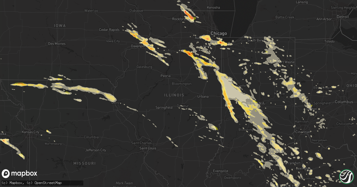
Hail Map in Illinois on July 13, 2015
Get this storm
July 13 map
$229
one time, instant access
Download today. No call, no setup
Keep the $229
Bought the map and want the full workflow? Apply the entire $229 to a subscription within 7 days. None of it is wasted.
Every map, not just this one
This buys you this map. Subscription and you get every map we run, in the markets you choose from a few cities to whole states to nationwide. Plus real-time alerts the moment a storm fires.
Contact data
Name, contact info, occupancy, even credit band for addresses in the footprint. You go from where it hit to who to call.
Become the source they trust
Unlimited branding weather history reports on demand. You already have the documented answer ready for the property owner, and you are the one who showed up with it.
Property data and RoofTrace estimates
Pull up any address you have got, its value and the exact code rules for that jurisdiction, straight from One Click Code. Then RoofTrace estimates the squares, pitch, and roof value, priced the way you price.
Storm reports in Illinois
Illinois
| Date | Description |
|---|---|
| 07/13/20156:55 PM CDT | A local report indicates 61 MPH wind near 2 NE PITTSFIELD |
| 07/13/20156:55 PM CDT | Several large tree limbs down. |
| 07/13/20156:51 PM CDT | Numerous tree limbs downed. |
| 07/13/20156:50 PM CDT | Large tree uprooted |
| 07/13/20156:47 PM CDT | Tree and vehicle damage reported. |
| 07/13/20156:45 PM CDT | Large teee down on highway 107. |
| 07/13/20156:40 PM CDT | Sixty foot tall tree downed. |
| 07/13/20156:39 PM CDT | Trees down. Siding ripped off house. |
| 07/13/20156:36 PM CDT | Wind blew antenna down |
| 07/13/20156:30 PM CDT | 1-2 foot diameter trees blown down at the roots |
| 07/13/20156:26 PM CDT | The town is near quincy illinois. |
| 07/13/20156:25 PM CDT | Public report via facebook. Delayed report. |
| 07/13/20156:25 PM CDT | A local report indicates 63 MPH wind near 4 NE BURTON |
| 07/13/20156:25 PM CDT | Trees uprooted |
| 07/13/20156:22 PM CDT | Peak wind gust measured at the kuin asos |
| 07/13/20156:22 PM CDT | 67 mph wind gust at uin |
| 07/13/20156:22 PM CDT | Multiple reports of trees and power lines down in quincy. |
| 07/13/20156:21 PM CDT | Large limbs downed. |
| 07/13/20156:20 PM CDT | A few branches blown down. Strong winds lasted about 10 minutes. |
| 07/13/20156:20 PM CDT | 16 inch diameter tree uprooted. Cottonwood tree damaged. |
| 07/13/20156:14 PM CDT | Rotation in clouds sighted. |
| 07/13/20156:05 PM CDT | Golf ball size hail near geneseo. Delayed report. |
| 07/13/20156:03 PM CDT | Quarter to ping pong ball sized hail |
| 07/13/20155:52 PM CDT | A local report indicates 2.75 inch wind near MARSEILLES |
| 07/13/20155:50 PM CDT | Numerous reports of baseball size hail from marseilles. |
| 07/13/20155:49 PM CDT | Penny to quarter size. Near 2653 and 2350 road. Social media. |
| 07/13/20155:40 PM CDT | North of route 6. |
| 07/13/201510:20 AM CDT | Tree and power lines down on douglas st. |
| 07/13/20159:49 AM CDT | Tree down across railroad tracks at 3rd street |
| 07/13/20159:45 AM CDT | Tree and power lines down 2650 n |
| 07/13/20159:20 AM CDT | Large tree limbs down and a shed damaged by wind |
| 07/13/20159:15 AM CDT | A local report indicates 1.00 inch wind near 2 SE CASTLETON |
| 07/13/20158:50 AM CDT | Relayed by wqad and kwqc twitter feeds. |
| 07/13/20152:07 AM CDT | Sustained 40-45 mph |
| 07/13/20152:07 AM CDT | A local report indicates 1.00 inch wind near WEST YORK |
| 07/13/20151:45 AM CDT | Trees and power lines down in casey. |
| 07/13/20151:00 AM CDT | Tree and powerlines down |
| 07/12/20159:45 PM CDT | A local report indicates 1.50 inch wind near 3 NW MARENGO |
| 07/12/20159:31 PM CDT | 12 to 15 inch diameter branches down. Power lines also down. Hunter road and route 76. |
| 07/12/20159:20 PM CDT | Thunderstorm wind damage snapped 15 inch tree. Hunter road and leroy center road. |
| 07/12/20159:20 PM CDT | Numerous large limbs blown down on the south side of town. |
| 07/12/20159:11 PM CDT | 76 and 173 |
| 07/12/20159:07 PM CDT | Power lines and limbs blown down around town. |
| 07/12/20159:05 PM CDT | Electric pole blown over onto a house on orchard drive. Also...numerous large limbs blown down around town. |
| 07/12/20158:59 PM CDT | A local report indicates 1.25 inch wind near DOWNERS GROVE |
| 07/12/20158:56 PM CDT | A local report indicates 2.50 inch wind near WOODRIDGE |
| 07/12/20158:56 PM CDT | Social media. |
| 07/12/20158:55 PM CDT | Brown ct and augustana dr. Hail lasted 5 minutes. |
| 07/12/20158:52 PM CDT | Green valley forest perserve |
| 07/12/20158:51 PM CDT | A local report indicates 1.00 inch wind near WOODRIDGE |
| 07/12/20158:49 PM CDT | Hobson and greene |
| 07/12/20158:36 PM CDT | Relayed from paducah by one of their spotters in greenville. |
| 07/12/20158:36 PM CDT | Relayed from paducah by one of their spotters in greenville. |
| 07/12/20158:30 PM CDT | Wind damage to live healthy trees. Limbs in excess of 2 inches in diameter damaged. Report was delayed...time estimated from radar. |
| 07/12/20158:30 PM CDT | Large tree limbs blown down at 7 to 8 inch diameter |
| 07/12/20158:13 PM CDT | A local report indicates 60 MPH wind near 1 N LITCHFIELD |
| 07/12/20157:56 PM CDT | Fences blown down. Minor roof damage. |
| 07/12/20157:55 PM CDT | Roof damage to an assisted living bulding nursing home one half mile west of carlinville and a roof blown off an apartment building in carlinville |
| 07/12/20157:51 PM CDT | Telephone pole snapped and large tree downed. |
| 07/12/20157:45 PM CDT | Minor tree limbs broken off |
| 07/12/20157:45 PM CDT | Several large tree branches blown down on the southern half of pawnee. |
| 07/12/20157:45 PM CDT | 4-6 inch limbs blown down blocking traffic |
| 07/12/20157:42 PM CDT | 154th and burnham. |
| 07/12/20157:40 PM CDT | Sibley blvd and burton ave. |
| 07/12/20157:39 PM CDT | Minor roof and tree damage. Broken house windows. |
| 07/12/20157:35 PM CDT | Power lines down blocking highway 111. Some trees down across town as well. |
| 07/12/20157:30 PM CDT | Tree split landing on house...large tree was blown down on garage. |
| 07/12/20157:30 PM CDT | 6 foot diameter tree blown down |
| 07/12/20157:20 PM CDT | Two to four inch diameter tree limbs blown down in murrayville. |
| 07/12/20157:20 PM CDT | Half dollar to golfball size hail. |
| 07/12/20157:18 PM CDT | Estimated 60 plus mph wind gusts blew large tree limbs down...as well as shingles blown across the road on south westgate ave. |
| 07/12/20157:18 PM CDT | Estimated 60 plus mph wind gusts blew large tree limbs down...as well as shingles blown across the road on south westgate ave. |
| 07/12/20157:18 PM CDT | Power poles blown down with estimated 60 to 70 mph winds on the south side of jacksonville. |
| 07/12/20157:18 PM CDT | Power poles blown down with estimated 60-70 mph wind gust on the south side of jacksonville |
| 07/12/20157:10 PM CDT | Trees and powerlines blown down 3 miles southwest of winchester. |
| 07/12/20157:05 PM CDT | Mostly dime sized hail but some as large as quarters. Delayed report. |
| 07/12/20157:04 PM CDT | Power outages in chapin |
All States Impacted by Hail Map on July 13, 2015
Cities Impacted by Hail Map on July 13, 2015
- Corydon, IN
- McClellanville, SC
- Lineville, IA
- Davis City, IA
- Blythedale, MO
- Templeton, IN
- Oxford, IN
- Holcomb, KS
- Garden City, KS
- Shipshewana, IN
- Millersburg, IN
- Middlebury, IN
- Topeka, IN
- Goshen, IN
- Woodruff, SC
- Delphi, IN
- Knapp, WI
- Glenwood City, WI
- Wilson, WI
- Woodville, WI
- Seneca, IL
- Marseilles, IL
- Troy, NC
- Grand Ridge, IL
- Ottawa, IL
- Vallonia, IN
- Scottsburg, IN
- Salem, IN
- Munster, IN
- Chicago Heights, IL
- Calumet City, IL
- Riverdale, IL
- Gary, IN
- Hammond, IN
- Blue Island, IL
- Hobart, IN
- Highland, IN
- Dolton, IL
- East Chicago, IN
- Markham, IL
- Chicago, IL
- Lansing, IL
- Lake Station, IN
- Griffith, IN
- Harvey, IL
- Whiting, IN
- South Holland, IL
- Thornton, IL
- Turon, KS
- Arlington, KS
- Osseo, WI
- Alma Center, WI
- Hixton, WI
- Prophetstown, IL
- New Bedford, IL
- Tampico, IL
- Walnut, IL
- Lyons, KS
- Nickerson, KS
- Little River, KS
- Inman, KS
- Hutchinson, KS
- Sterling, KS
- Caledonia, IL
- Clinton, WI
- Marengo, IL
- Harvard, IL
- Garden Prairie, IL
- South Beloit, IL
- Poplar Grove, IL
- Capron, IL
- Lafayette, IN
- Campbellsville, KY
- Fort Atkinson, WI
- Cambridge, WI
- Edgerton, WI
- Wheatland, IA
- Grand Mound, IA
- Lowden, IA
- Donahue, IA
- Long Grove, IA
- Calamus, IA
- Petroleum, IN
- Bluffton, IN
- Poneto, IN
- Keystone, IN
- Union City, OH
- Portland, IN
- Union City, IN
- New Weston, OH
- Ansonia, OH
- Lynn, IN
- Winchester, IN
- Fort Recovery, OH
- Ridgeville, IN
- Greenville, OH
- Amery, WI
- Balsam Lake, WI
- South Whitley, IN
- Columbia City, IN
- Larwill, IN
- Tinley Park, IL
- Orland Park, IL
- Mcpherson, KS
- St John, KS
- Great Bend, KS
- Hudson, KS
- Ellinwood, KS
- Schoolcraft, MI
- Cedar Grove, NC
- Westby, WI
- Cashton, WI
- Roberts, IL
- Buckley, IL
- Thawville, IL
- Versailles, KY
- Nicholasville, KY
- Creola, OH
- Mooresburg, TN
- Thorn Hill, TN
- Lancaster, SC
- Catawba, SC
- Ravenna, KY
- Clay City, KY
- Lakin, KS
- Vanceburg, KY
- Cimarron, KS
- Huntington, IN
- Williamsport, IN
- West Lebanon, IN
- Covington, IN
- Veedersburg, IN
- Kingman, IN
- Sparta, WI
- Rockland, WI
- Bangor, WI
- West Salem, WI
- Allerton, IA
- Corydon, IA
- New Era, MI
- Montague, MI
- Cedar Lake, IN
- Crown Point, IN
- Saint John, IN
- Schererville, IN
- Greensburg, KY
- New London, WI
- Camden, IN
- Newton, IL
- Ingraham, IL
- Mattoon, IL
- Charleston, IL
- Humboldt, IL
- Whitehall, WI
- Taylor, WI
- Blair, WI
- Strawn, IL
- Chatsworth, IL
- Spartanburg, SC
- Chesnee, SC
- Brooklyn, MI
- Onsted, MI
- Aurora, IL
- Willowbrook, IL
- Downers Grove, IL
- Bolingbrook, IL
- Lemont, IL
- Darien, IL
- Naperville, IL
- Woodridge, IL
- Lisle, IL
- Leslie, GA
- Geneseo, IL
- Buckner, KY
- La Grange, KY
- Paris, KY
- Celina, TN
- Hope, KS
- Gypsum, KS
- Sneedville, TN
- Blackwater, VA
- Kyles Ford, TN
- Jonesville, VA
- Lima, OH
- Leesburg, IN
- Milton, KY
- Bedford, KY
- Hanover, IN
- Herscher, IL
- Paynesville, WV
- Edinburgh, IN
- Columbus, IN
- Edmonton, KY
- Burkesville, KY
- Le Claire, IA
- Port Byron, IL
- Kirksville, MO
- Brashear, MO
- Novinger, MO
- Greentop, MO
- Queen City, MO
- Wellington, MO
- Germanton, NC
- Walnut Cove, NC
- Fort Mill, SC
- Rock Hill, SC
- Portage, WI
- Poynette, WI
- Winnsboro, SC
- Ridgeway, SC
- Dodge, WI
- La Crosse, WI
- Trempealeau, WI
- Viola, WI
- Onalaska, WI
- Holmen, WI
- Coon Valley, WI
- Fountain City, WI
- La Farge, WI
- Winona, MN
- Galesville, WI
- Arcadia, WI
- Richmond, KY
- Winchester, KY
- Lexington, KY
- Merrillville, IN
- Newton, KS
- North Newton, KS
- Bucklin, KS
- Ivanhoe, NC
- Harrells, NC
- Humboldt, NE
- Dunnellon, FL
- Great Falls, SC
- Galva, KS
- Rossville, IN
- Frankfort, IN
- Cutler, IN
- Lawrenceburg, KY
- Alden, KS
- Whitmire, SC
- Brooklyn, WI
- Marysville, OH
- Raymond, OH
- Richwood, OH
- Romeoville, IL
- Crest Hill, IL
- Lockport, IL
- Irvine, KY
- Winamac, IN
- Monterey, IN
- Martinsville, IN
- Mooers Forks, NY
- Commiskey, IN
- Paris Crossing, IN
- Atkinson, IL
- Cambridge, IL
- Shelbyville, KY
- Bagdad, KY
- Farmland, IN
- Bloomington, IN
- Camden, SC
- Lugoff, SC
- Elizabethtown, KY
- Valparaiso, IN
- Stockland, IL
- Bloomingdale, IN
- Kentland, IN
- Bridgeton, IN
- Knightsville, IN
- Centerpoint, IN
- Sheldon, IL
- Brazil, IN
- Wellington, IL
- Reelsville, IN
- Earl Park, IN
- Fowler, IN
- Harmony, IN
- Watseka, IL
- Rockville, IN
- Milford, IL
- Rosedale, IN
- Hoopeston, IL
- Ambia, IN
- Montezuma, IN
- Marshall, IN
- Carbon, IN
- Elmer, MO
- Ethel, MO
- New Boston, MO
- Cochrane, WI
- Fulton, MI
- Mendon, MI
- Oak Grove, MO
- Wyanet, IL
- Ottawa, KS
- Lorraine, KS
- Geneseo, KS
- Cambridge City, IN
- Youngstown, FL
- Urbana, OH
- De Graff, OH
- Merrimac, WI
- Stamping Ground, KY
- Lexington, NC
- Ravenwood, MO
- Maryville, MO
- Bethany, MO
- Sheridan, MO
- Ridgeway, MO
- Denver, MO
- Gentry, MO
- Albany, MO
- New Hampton, MO
- Worth, MO
- Martinsville, MO
- Burlington Junction, MO
- Hopkins, MO
- Pickering, MO
- Tarkio, MO
- Parnell, MO
- Eagleville, MO
- Baraboo, WI
- Rio, WI
- Paola, KS
- Fontana, KS
- Osawatomie, KS
- La Cygne, KS
- Waupaca, WI
- Hazel Crest, IL
- Midlothian, IL
- Oak Forest, IL
- Country Club Hills, IL
- Wilmington, NC
- Castle Hayne, NC
- Seymour, WI
- Rochester, IN
- Francesville, IN
- Asheboro, NC
- Sutherlin, VA
- Ringgold, VA
- Arlington, WI
- Harrodsburg, KY
- Krypton, KY
- Busy, KY
- Pembroke, NC
- Lumberton, NC
- Elon, NC
- Milton, NC
- Providence, NC
- Yanceyville, NC
- Mebane, NC
- Blanch, NC
- Burlington, NC
- Mount Vernon, KY
- Berea, KY
- Tyner, KY
- Vincent, KY
- Wellington, KY
- Campton, KY
- Pennville, IN
- Kewanee, IL
- Monroeville, IN
- Nineveh, IN
- Nashville, IN
- Moore Haven, FL
- Vienna, GA
- Muskegon, MI
- Twin Lake, MI
- Clarence, IA
- Spickard, MO
- Galt, MO
- Humphreys, MO
- Princeton, MO
- Milan, MO
- Mount Pleasant, SC
- Awendaw, SC
- Adrian, GA
- Utica, IL
- Syracuse, IN
- Ligonier, IN
- Delmar, IA
- Oxford Junction, IA
- Lost Nation, IA
- De Witt, IA
- Morgantown, IN
- Sparland, IL
- Russell Springs, KY
- Dunnville, KY
- Hanston, KS
- Larned, KS
- Green Bay, WI
- Bristol, IN
- Luck, WI
- Centuria, WI
- Cushing, WI
- Milltown, WI
- Monrovia, IN
- New Hope, KY
- Raywick, KY
- La Grange, IL
- Berwyn, IL
- Arcanum, OH
- Orlando, KY
- Crab Orchard, KY
- Brodhead, KY
- Strum, WI
- Fairchild, WI
- Jackson, KY
- Salyersville, KY
- Rousseau, KY
- Ford, KS
- Wilmington, IL
- Bonfield, IL
- Essex, IL
- Braceville, IL
- Braidwood, IL
- Ellsworth, KS
- Kanopolis, KS
- Pawnee Rock, KS
- Decatur, MI
- Lawrence, MI
- Paw Paw, MI
- Hartford, MI
- Wilmington, OH
- New Vienna, OH
- Whitehall, MI
- Kankakee, IL
- Overbrook, KS
- Carbondale, KS
- Martinsville, IL
- West Union, IL
- West York, IL
- Leland, NC
- Whitewater, KS
- Elbing, KS
- El Dorado, KS
- Cassoday, KS
- Burns, KS
- Potwin, KS
- Robinson, IL
- Hillsboro, OH
- Midland, OH
- Lynchburg, OH
- Martinsville, OH
- Englewood, OH
- Abbyville, KS
- Concord, VA
- North Troy, VT
- Newport Center, VT
- Newport, VT
- Verona, IL
- Salamonia, IN
- Dayton, OH
- Ash, NC
- Ocean Isle Beach, NC
- Scottville, MI
- Ludington, MI
- Neponset, IL
- Eutawville, SC
- Viroqua, WI
- Readstown, WI
- Smithville, GA
- De Soto, GA
- Elizabethton, TN
- Hampton, TN
- Butler, TN
- Dunkirk, IN
- McKee, KY
- Annville, KY
- Booneville, KY
- Danville, VA
- Claxton, GA
- Cobbtown, GA
- Collins, GA
- Kewaunee, WI
- Algoma, WI
- Casco, WI
- Zanesfield, OH
- Bellefontaine, OH
- Galien, MI
- New Buffalo, MI
- Rolling Prairie, IN
- La Porte, IN
- New Carlisle, IN
- Three Oaks, MI
- Cynthiana, KY
- Albion, IN
- Kimmell, IN
- Beattyville, KY
- Cainsville, MO
- Madison, WI
- Waunakee, WI
- Newaygo, MI
- Somerset, OH
- Seymour, IN
- Sullivan, IL
- Douglas, AZ
- Tiskilwa, IL
- Princeton, IL
- Shiocton, WI
- Black River Falls, WI
- Mondovi, WI
- Durand, WI
- Melrose, WI
- Menomonie, WI
- Fall Creek, WI
- Eau Claire, WI
- Eleva, WI
- Janesville, WI
- Kouts, IN
- Saint Croix Falls, WI
- Roanoke, IN
- Yoder, IN
- Fort Wayne, IN
- Warsaw, IN
- Milford, IN
- Hyde Park, VT
- Morrisville, VT
- Johnson City, TN
- Beverly, KS
- Manteno, IL
- Bourbonnais, IL
- Buckhorn, KY
- Gays Creek, KY
- Union, IL
- Champlain, NY
- West Chazy, NY
- Chazy, NY
- Longwood, NC
- Sunset Beach, NC
- Clayton, OH
- Brookville, OH
- Muncie, IN
- Bluff City, TN
- Egg Harbor, WI
- Modoc, IN
- Avon, IN
- Darlington, SC
- Inman, SC
- Bolton, NC
- Procious, WV
- Crestwood, KY
- Lone Rock, WI
- Avoca, WI
- Spring Green, WI
- Ridgeway, WI
- Arena, WI
- Richland Center, WI
- Dodgeville, WI
- Sister Bay, WI
- Mercer, MO
- Berne, IN
- Montpelier, IN
- Hartford City, IN
- Geneva, IN
- Bryant, IN
- New Middletown, IN
- Elizabeth, IN
- New London, NC
- Albemarle, NC
- Elkhart, IN
- Casa Blanca, NM
- Ingalls, KS
- Jetmore, KS
- Belvidere, IL
- Huntertown, IN
- Churubusco, IN
- Laotto, IN
- Green City, MO
- Rutledge, MO
- Worthington, MO
- Memphis, MO
- Green Castle, MO
- Baring, MO
- Pollock, MO
- Edina, MO
- Knox City, MO
- Unionville, MO
- Downing, MO
- Lewistown, MO
- Canton, MO
- La Grange, MO
- Monticello, MO
- Willisburg, KY
- Wausau, WI
- Merrill, WI
- Antigo, WI
- Moncks Corner, SC
- Milwaukee, WI
- Montezuma, KS
- Battle Creek, MI
- Ceresco, MI
- Burgaw, NC
- Willard, NC
- Seymour, IA
- Mattoon, WI
- New Franken, WI
- Boiling Springs, SC
- Centreville, MI
- Three Rivers, MI
- Sturgis, MI
- Petersburg, VA
- Campobello, SC
- Wellford, SC
- Moore, SC
- Long Creek, OR
- Anderson, IN
- Saint Henry, OH
- Portage, IN
- Leonidas, MI
- Vicksburg, MI
- Columbia, KY
- Marcellus, MI
- Browns Summit, NC
- Gibsonville, NC
- Vancleve, KY
- Frenchburg, KY
- Slade, KY
- East Bend, NC
- Bourbon, IN
- Plymouth, IN
- Grant, MI
- Ravenna, MI
- Nancy, KY
- Gardner, IL
- Buckingham, IL
- Reddick, IL
- Chebanse, IL
- North Vernon, IN
- Allons, TN
- Hilham, TN
- Bardstown, KY
- Coxs Creek, KY
- Birnamwood, WI
- Aniwa, WI
- Bloomfield, KY
- Austin, IN
- Freetown, IN
- Eidson, TN
- New Liberty, KY
- Owenton, KY
- Corinth, KY
- Simpsonville, KY
- Waddy, KY
- Mount Eden, KY
- Louisville, KY
- Fisherville, KY
- Finchville, KY
- Chaplin, KY
- Taylorsville, KY
- Otisco, IN
- Underwood, IN
- Marysville, IN
- Glencoe, KY
- Warsaw, KY
- Wild Rose, WI
- Pine River, WI
- Redgranite, WI
- Fayetteville, NC
- Westmont, IL
- New Paris, OH
- Mayesville, SC
- Rocky Point, NC
- Frankfort, KY
- Supply, NC
- Whitestown, IN
- Zionsville, IN
- Richmond Hill, GA
- Saltville, VA
- Somerset, KY
- Rockford, MI
- Belmont, MI
- Ada, MI
- Lake Placid, FL
- Spencer, IN
- Burnettsville, IN
- Star City, IN
- Royal Center, IN
- Idaville, IN
- Monticello, IN
- Logansport, IN
- Pageland, SC
- Marshville, NC
- Blountville, TN
- Kingsport, TN
- West Lafayette, IN
- New Ross, IN
- Crawfordsville, IN
- Hillsboro, IN
- Colfax, IN
- Romney, IN
- Thorntown, IN
- New Richmond, IN
- Pine Village, IN
- Attica, IN
- Linden, IN
- Wingate, IN
- Lebanon, IN
- Darlington, IN
- Mellott, IN
- Ladoga, IN
- Boswell, IN
- Otterbein, IN
- Westpoint, IN
- Waynetown, IN
- Newtown, IN
- Jamestown, IN
- Mayview, MO
- Ossian, IN
- Lynchburg, VA
- Wheeler, WI
- Donovan, IL
- Clifton, IL
- Papineau, IL
- Saint Anne, IL
- Beaverville, IL
- Martinton, IL
- Cabery, IL
- Hardinsburg, IN
- Fredericksburg, IN
- Chase, KS
- Star, NC
- Annawan, IL
- Grantsburg, WI
- Piper City, IL
- Blythewood, SC
- East Moline, IL
- Rapids City, IL
- Bettendorf, IA
- Cordova, IL
- Hillsdale, IL
- Eldridge, IA
- Davenport, IA
- Princeton, IA
- McCausland, IA
- Tollesboro, KY
- Plevna, KS
- Odell, IL
- Hodgenville, KY
- Buda, IL
- Bradford, IL
- Cecil, WI
- South Bend, IN
- Green Sea, SC
- Bladenboro, NC
- Roodhouse, IL
- Winchester, IL
- Cullom, IL
- Saunemin, IL
- Shepherdsville, KY
- Coatesville, IN
- Stilesville, IN
- Mooresville, IN
- Clayton, IN
- Plainfield, IN
- Danville, IN
- Ramsey, IN
- Copeland, KS
- Colon, MI
- Allegan, MI
- Hopkins, MI
- Mount Olive, NC
- Decatur, IL
- Cassopolis, MI
- Jones, MI
- Vandalia, MI
- Clio, SC
- Bradford, OH
- Clayhole, KY
- Lost Creek, KY
- Borden, IN
- Pekin, IN
- Emington, IL
- Covington, OH
- Baileys Harbor, WI
- Akron, IN
- Clarks Hill, IN
- Ramseur, NC
- Franklinville, NC
- Staley, NC
- Dowagiac, MI
- Jackson, OH
- Fillmore, IN
- Cloverdale, IN
- Quincy, IN
- Cottage Grove, WI
- Clarendon Hills, IL
- Alton, VA
- Brownstown, IN
- Newark, MO
- La Belle, MO
- Ewing, MO
- Ohio City, OH
- Van Wert, OH
- Matewan, WV
- Wharncliffe, WV
- Deerfield, KS
- Dillon, SC
- Wyoming, IL
- Soldiers Grove, WI
- Yale, IL
- Oblong, IL
- Medaryville, IN
- North Judson, IN
- Gravel Switch, KY
- Lebanon, KY
- Carlinville, IL
- Hettick, IL
- Kewanna, IN
- Charlestown, IN
- North Charleston, SC
- Ladson, SC
- Scott City, KS
- Laurelville, OH
- Kingston, OH
- Winigan, MO
- Middle Point, OH
- Hampton, IL
- Colona, IL
- Camanche, IA
- Kingman, KS
- Buffalo, KY
- New Haven, KY
- Mount Sherman, KY
- Summersville, KY
- Milltown, IN
- Depauw, IN
- Georgetown, IN
- Brooks, KY
- Laconia, IN
- New Salisbury, IN
- Crandall, IN
- Fairdale, KY
- Lanesville, IN
- New Albany, IN
- Kirklin, IN
- Kempton, IN
- Sheridan, IN
- Michigantown, IN
- Marion, IN
- Van Buren, IN
- Roachdale, IN
- Bainbridge, IN
- Amo, IN
- North Salem, IN
- Randolph, VA
- Brookneal, VA
- Charlotte Court House, VA
- Phenix, VA
- Saxe, VA
- Sanderson, FL
- Arcadia, FL
- Cicero, IN
- Arcadia, IN
- Atlanta, IN
- Waukesha, WI
- Delafield, WI
- Nashotah, WI
- Hartland, WI
- Pewaukee, WI
- Bluffs, IL
- Prestonsburg, KY
- Whiteville, NC
- Windom, KS
- Chesterton, IN
- Penhook, VA
- Americus, GA
- Red House, VA
- Longs, SC
- Loris, SC
- Olive Hill, KY
- Morehead, KY
- Mooers, NY
- Altona, NY
- Moorefield, KY
- Mayslick, KY
- Flemingsburg, KY
- Mount Olivet, KY
- Ewing, KY
- Carlisle, KY
- Greenville, IL
- Yorkville, IL
- Dry Ridge, KY
- Jonesville, KY
- McCarr, KY
- Stopover, KY
- Freeburn, KY
- Majestic, KY
- Macon, IL
- Dalton City, IL
- Dwight, IL
- Mazon, IL
- Kempton, IL
- Ransom, IL
- Campus, IL
- Kinsman, IL
- Plainfield, WI
- Almond, WI
- Plover, WI
- Bancroft, WI
- Wisconsin Rapids, WI
- Amherst, WI
- Bellbrook, OH
- Spring Valley, OH
- Xenia, OH
- Miamisburg, OH
- Waynesville, OH
- Springboro, OH
- Berryton, KS
- McBee, SC
- Dupont, IN
- Madison, IN
- Beloit, WI
- Woodstock, IL
- Gate City, VA
- Church Hill, TN
- Wingate, NC
- Monroe, NC
- Daleville, AL
- Johnson, NE
- Tecumseh, NE
- Lawrence, NE
- Shady Valley, TN
- Metter, GA
- Register, GA
- Sorento, IL
- Welch, WV
- Anawalt, WV
- Mozelle, KY
- Warbranch, KY
- Cubero, NM
- Pueblo Of Acoma, NM
- Rogersville, TN
- Bringhurst, IN
- Flora, IN
- Homewood, IL
- Quincy, IL
- Liberty Hill, SC
- Hazel Green, KY
- Clarkton, NC
- Florence, SC
- Wisconsin Dells, WI
- Berry, KY
- Needham, IN
- Stinnett, KY
- Hyden, KY
- Gays, IL
- Elburn, IL
- Sugar Grove, IL
- Monmouth, IA
- Wyoming, IA
- Campbellsburg, IN
- Bowling Green, IN
- Poland, IN
- Currie, NC
- Churubusco, NY
- Sublette, KS
- Claypool, IN
- Pierceton, IN
- Jackson Center, OH
- Maplewood, OH
- Stanford, KY
- Junction City, KY
- Salvisa, KY
- Pewee Valley, KY
- Mackville, KY
- Danville, KY
- Perryville, KY
- Lancaster, KY
- Brookville, KS
- Upland, IN
- Baldwin City, KS
- Lawrence, KS
- Wakarusa, KS
- Yorktown, IN
- Daleville, IN
- La Salle, IL
- Harts, WV
- Matfield Green, KS
- Sandgap, KY
- Gladstone, VA
- Lamar, SC
- Independence, WI
- Sheffield, IL
- Lucerne, MO
- White Cloud, MI
- West Liberty, KY
- Buhler, KS
- Goshen, OH
- Pleasant Plain, OH
- New Glarus, WI
- Belleville, WI
- Piney Flats, TN
- Niles, MI
- Buchanan, MI
- Greeneville, TN
- Parrottsville, TN
- Crete, IL
- Dyer, IN
- Wilmore, KY
- Oneida, WI
- Black Creek, WI
- Lexington, NE
- New Lenox, IL
- Mokena, IL
- Homer Glen, IL
- Beech Grove, IN
- Indianapolis, IN
- Union, MI
- White Pigeon, MI
- Fedscreek, KY
- Steele, KY
- Topeka, KS
- Sumner, IL
- Tomah, WI
- Elwood, IL
- Morris, IL
- Newark, IL
- Minooka, IL
- Shorewood, IL
- Joliet, IL
- Channahon, IL
- Manhattan, IL
- Palestine, IL
- Carlisle, IN
- Harrison, OH
- West Harrison, IN
- Lawrenceburg, IN
- Nunica, MI
- Coopersville, MI
- Fruitport, MI
- Pierceville, KS
- Kent City, MI
- Harris, MO
- Ursa, IL
- Newtown, MO
- Durham, MO
- Hurdland, MO
- Maywood, MO
- Williamstown, MO
- Mill Creek, IN
- Hinckley, IL
- Hampstead, NC
- Casey, IL
- Blanchester, OH
- Clarksville, OH
- Delbarton, WV
- Dodge City, KS
- Alto, MI
- Randleman, NC
- Climax, NC
- Deer Grove, IL
- Appomattox, VA
- Waynesburg, KY
- Crivitz, WI
- Elgin, SC
- Tabor City, NC
- Cherry Valley, IL
- Covington, KY
- Bedford, VA
- Knifley, KY
- Greenfield, IL
- Skidmore, MO
- Fairfax, MO
- Ellettsville, IN
- Gosport, IN
- Clifford, IN
- Hope, IN
- Taylorsville, IN
- Rossburg, OH
- Verona, KY
- London, KY
- Floyds Knobs, IN
- Montgomery Center, VT
- Wellsville, KS
- Rantoul, KS
- Grand Rapids, MI
- Plainwell, MI
- Martin, MI
- Otsego, MI
- Markle, IN
- Warren, IN
- Barneveld, WI
- Mount Horeb, WI
- Hillsboro, WI
- Genoa, WI
- Hillpoint, WI
- Blue Mounds, WI
- Gradyville, KY
- Magnolia, KY
- Breeding, KY
- Tompkinsville, KY
- Startex, SC
- Duncan, SC
- Gas City, IN
- Jonesboro, IN
- Fairmount, IN
- Loda, IL
- Radnor, OH
- Tazewell, TN
- Ludlow Falls, OH
- Redkey, IN
- Pleasant Hill, OH
- Laura, OH
- Pitsburg, OH
- West Milton, OH
- Phillipsburg, OH
- Tipp City, OH
- Vandalia, OH
- Gettysburg, OH
- Versailles, OH
- Salt Lick, KY
- Ness City, KS
- Sadieville, KY
- Warrensburg, MO
- Charlotte, NC
- Waxhaw, NC
- Posen, IL
- Columbus, WI
- Lagrange, IN
- Howe, IN
- Pendleton, IN
- Wilkinson, IN
- Greenfield, IN
- Humeston, IA
- Keyesport, IL
- Monroe, VA
- Madison Heights, VA
- Ezel, KY
- Canaan, IN
- Butlerville, IN
- Nabb, IN
- Lexington, IN
- Deputy, IN
- Deforest, WI
- Hutsonville, IL
- Lizton, IN
- Norman, IN
- Medora, IN
- Bedford, IN
- Heltonville, IN
- Greenwood, IN
- Franklin, IN
- Whiteland, IN
- Leon, IA
- Forest, VA
- Oshkosh, WI
- Amelia, OH
- New Richmond, OH
- Lerna, IL
- Caledonia, MI
- Fountain, FL
- Syracuse, KS
- Kendallville, IN
- Leo, IN
- Auburn, IN
- Pendleton, KY
- Bethlehem, IN
- New Washington, IN
- Buckingham, VA
- Blenheim, SC
- Bennettsville, SC
- Cedar Bluff, VA
- Honaker, VA
- Sandoval, IL
- Carlyle, IL
- Parker, KS
- Lodi, WI
- Sauk City, WI
- Dane, WI
- Cross Plains, WI
- Jamestown, OH
- Port William, OH
- Clear Lake, WI
- Prospect, KY
- Goshen, KY
- Uniondale, IN
- Craigville, IN
- Dover, KY
- Hamlin, WV
- Woodstock, OH
- Milford Center, OH
- Bradfordsville, KY
- New Castle, KY
- Pleasureville, KY
- Campbellsburg, KY
- Sulphur, KY
- La Fontaine, IN
- Wheeler, IL
- Dillsboro, IN
- Bennington, IN
- Rising Sun, IN
- Georgetown, KY
- Maquoketa, IA
- Baldwin, IA
- Greenup, IL
- Arrington, VA
- Lynchburg, SC
- Lexington, MO
- Odessa, MO
- Fremont, MI
- Holton, MI
- Rosewood, OH
- Saint Paris, OH
- Conover, OH
- West Liberty, OH
- Eubank, KY
- Peru, IN
- Liberty Center, IN
- Wright, KS
- Clarendon, NC
- Nathalie, VA
- Denton, NC
- Nichols, SC
- Lamoni, IA
- Kellerton, IA
- Cable, OH
- North Lewisburg, OH
- Pineville, NC
- Cross, SC
- Suamico, WI
- Luxemburg, WI
- Little Suamico, WI
- Galva, IL
- Pleasant Valley, IA
- Erie, IL
- Chillicothe, IL
- Toulon, IL
- Athelstane, WI
- Belding, MI
- Saranac, MI
- Lowell, MI
- Alexandria, KY
- Moundridge, KS
- Rustburg, VA
- Hazard, KY
- Rowdy, KY
- Harbert, MI
- Sawyer, MI
- Bridgman, MI
- Trinity, NC
- Sophia, NC
- High Point, NC
- Monee, IL
- Frankfort, IL
- Huger, SC
- Sandwich, IL
- Matthews, IN
- Silver City, IA
- Mount Sterling, KY
- Delton, MI
- Pratt, KS
- Altura, MN
- Alma, WI
- Neoga, IL
- Palmyra, IN
- Greenville, IN
- Griggsville, IL
- Liberty, IL
- Barry, IL
- Baylis, IL
- Vevay, IN
- Abingdon, VA
- Marion, VA
- Myrtle Beach, SC
- Camp Douglas, WI
- Charleston, SC
- Boyceville, WI
- Richland, MI
- Hickory Corners, MI
- Constantine, MI
- Orleans, MI
- Bishopville, SC
- Webbville, KY
- Grayson, KY
- Sandy Hook, KY
- Mentone, IN
- Lucerne, IN
- Wooton, KY
- Reidsville, NC
- Oswego, IL
- Union, SC
- Enoree, SC
- Olin, IA
- Elkfork, KY
- Flatgap, KY
- Piqua, OH
- Bethune, SC
- Clover, VA
- Drakes Branch, VA
- Gladys, VA
- Decatur, IA
- Little Rock, SC
- Windsor, KY
- Bangor, MI
- Covert, MI
- Milton, IN
- Dunlow, WV
- Partridge, KS
- Pittsboro, IN
- Boggstown, IN
- Brooklyn, IN
- Shelbyville, IN
- Brownsburg, IN
- Lockport, KY
- Roanoke, VA
- Muir, MI
- Ionia, MI
- Fenwick, MI
- Williamsburg, OH
- Mount Orab, OH
- Ostrander, OH
- Atkinson, NC
- Lane, KS
- Pomona, KS
- Boston, KY
- Lebanon Junction, KY
- Hartsville, SC
- Manchester, KY
- Brookfield, WI
- Elm Grove, WI
- Westfield, IL
- Omro, WI
- Greensboro, NC
- East Liberty, OH
- Kirkland, IL
- Clare, IL
- Hesperia, MI
- Sanders, KY
- Sparta, KY
- York, SC
- Wabash, IN
- Avalon, WI
- Darien, WI
- Sharon, WI
- Walworth, WI
- Swainsboro, GA
- Soperton, GA
- Kite, GA
- North Manchester, IN
- Sheridan, IL
- Millington, IL
- Serena, IL
- Pounding Mill, VA
- Jonesborough, TN
- Dillwyn, VA
- Howardsville, VA
- Hallsboro, NC
- North Myrtle Beach, SC
- Calabash, NC
- Shallotte, NC
- Delco, NC
- Lake Waccamaw, NC
- Bolivia, NC
- Little River, SC
- Nakina, NC
- Winnabow, NC
- Marengo, IN
- Whitley City, KY
- Carrollton, KY
- Turners Station, KY
- Corbin, KY
- Oneida, KY
- Ricetown, KY
- Mistletoe, KY
- Rothbury, MI
- Germantown, OH
- Arthur, IL
- Corning, OH
- Colfax, WI
- New Palestine, IN
- South Bloomingville, OH
- Goose Creek, SC
- Hope Mills, NC
- Hamilton, OH
- Paoli, IN
- Thornville, OH
- Scott, OH
- Yellow Springs, OH
- Lick Creek, KY
- Harrogate, TN
- Wonewoc, WI
- Delavan, WI
- Sheboygan, WI
- Byron Center, MI
- Owingsville, KY
- Onslow, IA
- Wapakoneta, OH
- Spencerville, OH
- Wawaka, IN
- New Paris, IN
- North Webster, IN
- Winona Lake, IN
- Silver Lake, IN
- Nappanee, IN
- Cromwell, IN
- Edwardsburg, MI
- Avilla, IN
- Etna Green, IN
- New Castle, IN
- Hagerstown, IN
- Mooreland, IN
- Hubbardston, MI
- Carson City, MI
- Delaware, OH
- Norwalk, WI
- Osco, IL
- Liberty, NC
- Andrews, IN
- Lagro, IN
- Urbana, IN
- Stanton, KY
- Jeffersonville, IN
- Masonic Home, KY
- Palos Heights, IL
- Warrenville, IL
- North Aurora, IL
- Wheaton, IL
- Crestwood, IL
- Robbins, IL
- Willow Springs, IL
- Palos Park, IL
- Glen Ellyn, IL
- Alsip, IL
- Evergreen Park, IL
- Convoy, OH
- Lovington, IL
- Barnard, MO
- Lake In The Hills, IL
- Crystal Lake, IL
- Algonquin, IL
- Huntley, IL
- Flat Rock, IL
- Manning, SC
- Conklin, MI
- Eaton, IN
- La Crosse, IN
- Reidsville, GA
- Raymond, KS
- Fort Stewart, GA
- Clewiston, FL
- Lake City, SC
- Shirley, IN
- Waco, KY
- Huntersville, NC
- Davidson, NC
- Vincennes, IN
- Necedah, WI
- New Lisbon, WI
- Lawrenceville, IL
- Cincinnati, OH
- Comstock Park, MI
- Sparta, MI
- Alkol, WV
- Fairmont, NC
- Livingston, KY
- Pilot Mountain, NC
- Versailles, IN
- Bear Creek, WI
- Lewistown, OH
- Callands, VA
- Axton, VA
- Auburn, NE
- Deerfield, WI
- Alcolu, SC
- Quincy, OH
- Sidney, OH
- Sextons Creek, KY
- Fulton, IL
- Harmon, IL
- Rock Falls, IL
- Fenton, IL
- Lyndon, IL
- Fayetteville, OH
- Ceres, VA
- Mcconnelsville, OH
- Blue Rock, OH
- Lyons, GA
- Zoe, KY
- Kiahsville, WV
- Ranger, WV
- South Hutchinson, KS
- Springfield, KY
- Hillsdale, IN
- Crothersville, IN
- Camby, IN
- Forrest, IL
- Westport, KY
- Scipio, IN
- Onarga, IL
- Jonesville, IN
- New Market, IN
- Elizabethtown, IN
- Coal City, IL
- Smithfield, KY
- Pontiac, IL
- Advance, IN
- Paragon, IN
- Flat Rock, IN
- Waveland, IN
- Perrysville, IN
- Gilman, IL
- Hartsville, IN
- Memphis, IN
- Henryville, IN
- Fairland, IN
- Trafalgar, IN
- Melvin, IL
- Bargersville, IN
- Carmel, IN
- Aroma Park, IL
- Mineral, IL
- Greensburg, IN
- Coldwater, OH
- Spring Lake, MI
- Annapolis, IL
- Sun Prairie, WI
- Marshall, WI
- Burrton, KS
- Kelly, NC
- Elizabethtown, NC
- Blue Ridge, VA
- Noblesville, IN
- Spencerville, IN
- Grabill, IN
- Elk Horn, KY
- Eminence, KY
- Iaeger, WV
- Lehigh Acres, FL
- Bonduel, WI
- Staffordsville, KY
- Wittensville, KY
- Sitka, KY
- Paintsville, KY
- West Alexandria, OH
- New Lebanon, OH
- Farmersville, OH
- Camden, OH
- Wallace, MI
- Ephraim, WI
- Menominee, MI
- Fish Creek, WI
- Ellison Bay, WI
- Sturgeon Bay, WI
- Summerton, SC
- Falun, KS
- Peru, IL
- Dalzell, IL
- Spring Valley, IL
- Williamstown, KY
- Ghent, KY
- Durham, KS
- Pawnee City, NE
- Arcadia, SC
- Una, SC
- Pauline, SC
- Jonesville, SC
- Lyman, SC
- Roebuck, SC
- Batavia, OH
- Milford, OH
- Clearmont, MO
- Henrietta, MO
- Humbird, WI
- Cowpens, SC
- Marshall, IL


