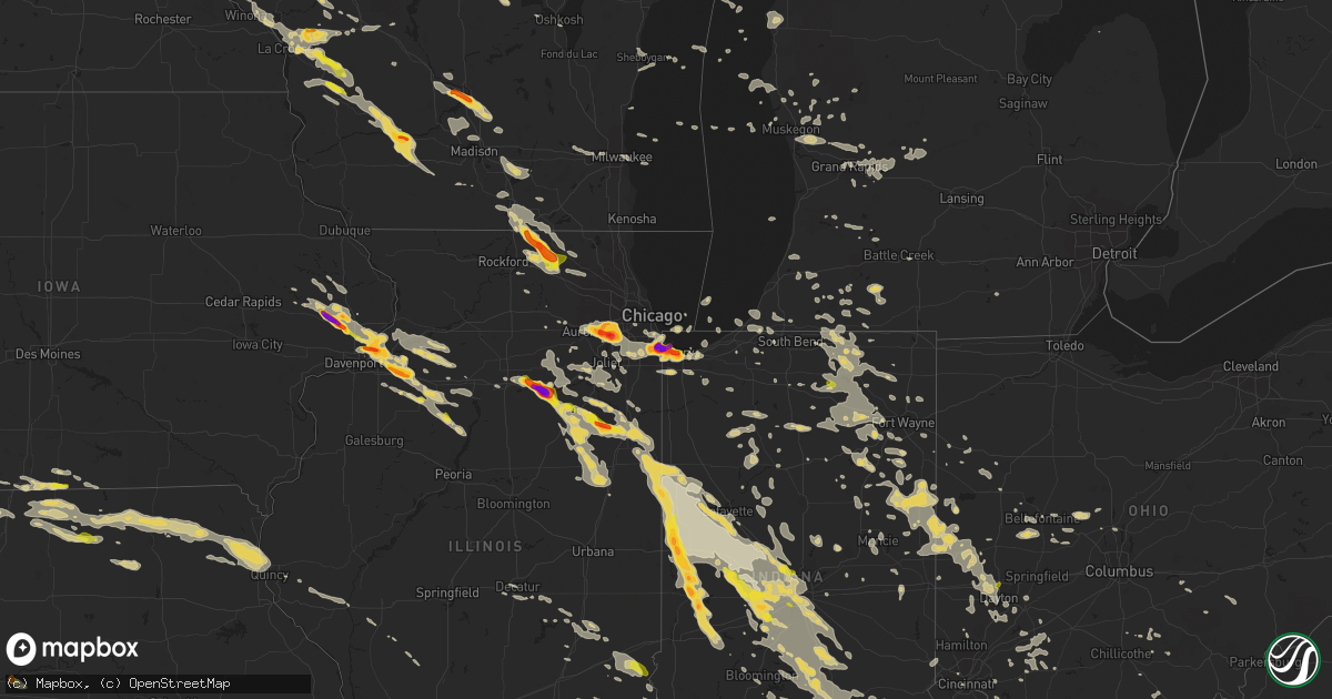
Hail Map on July 13, 2015
Get this storm
July 13 map
$229
one time, instant access
Download today. No call, no setup
Keep the $229
Bought the map and want the full workflow? Apply the entire $229 to a subscription within 7 days. None of it is wasted.
Every map, not just this one
This buys you this map. Subscription and you get every map we run, in the markets you choose from a few cities to whole states to nationwide. Plus real-time alerts the moment a storm fires.
Contact data
Name, contact info, occupancy, even credit band for addresses in the footprint. You go from where it hit to who to call.
Become the source they trust
Unlimited branding weather history reports on demand. You already have the documented answer ready for the property owner, and you are the one who showed up with it.
Property data and RoofTrace estimates
Pull up any address you have got, its value and the exact code rules for that jurisdiction, straight from One Click Code. Then RoofTrace estimates the squares, pitch, and roof value, priced the way you price.
States Impacted by Hail Map on July 13, 2015
Storm reports
Ohio
| Date | Description |
|---|---|
| 07/13/20152:54 PM CDT | Trees down in athalia. |
| 07/13/20152:15 PM CDT | Tree branches down in roads in oak hill |
| 07/13/20152:15 PM CDT | Jackson county 911 reports numerous trees down across the county... In the oak hill area |
| 07/13/20151:58 PM CDT | Numerous trees down across madison township in scioto county...especially along white gravel...warren hill...richard...dewey...and kulp roads. |
| 07/13/20151:52 PM CDT | Sr 52 closed at buena vista due to tree down across road. More than 50 other trees reported down on roadways across scioto county. |
| 07/13/20151:37 PM CDT | Tree limb fell on top of car. Time estimated from radar. |
| 07/13/20151:33 PM CDT | Tree down on house caused roof to cave in. Time estimated from radar. |
| 07/13/20151:32 PM CDT | Tree down on porch on millers run-fallen timber road. Time estimated from radar. |
| 07/13/20151:32 PM CDT | Tree down on mobile home on ruth ann drive. Time estimated from radar. |
| 07/13/20151:32 PM CDT | Several trees and power poles down. |
| 07/13/20151:13 PM CDT | Tree down on house. Time estimated from radar. |
| 07/13/20151:11 PM CDT | Multiple large limbs down. Time estimated from radar. Corrected report. |
| 07/13/20151:10 PM CDT | Significant wind damage to home. |
| 07/13/20151:08 PM CDT | Large tree down caused minor house damage. |
| 07/13/20151:04 PM CDT | One large tree down in front of mt logan elementary school. Time estimated from radar. |
| 07/13/201512:56 PM CDT | Small tree uprooted. Time estimated from radar. |
| 07/13/201512:48 PM CDT | Tree limb down on fence. Time estimated from radar. |
| 07/13/201512:46 PM CDT | One tree limb down. Time estimated from radar. |
| 07/13/201512:46 PM CDT | Numerous trees down on several houses. Prouty lane and ivy hill roads along with state route 62. Garage door blown in and wall blown outward from one residence...along |
| 07/13/201512:45 PM CDT | Several trees down across east walnut hills area. Time estimated from radar. |
| 07/13/201512:44 PM CDT | Tree fell onto garage in eastgate area. Time estimated from radar. |
| 07/13/201512:39 PM CDT | 3 inch diameter branches broken off and a 3 foot diameter portion of a tree was split by the wind. Time estimated from radar. |
| 07/13/201512:36 PM CDT | 8-10 inch diameter tree uprooted near the 1100 block of seymour avenue. Time estimated from radar. |
| 07/13/201512:34 PM CDT | Numerous reports of trees and wires down due to thunderstorm winds. |
| 07/13/201512:34 PM CDT | One tree down across keys crescent near madison rd. Time estimated from radar. |
| 07/13/201512:30 PM CDT | Several large trees down across north avondale area. Time estimated from radar. |
| 07/13/201512:30 PM CDT | Tree and large limbs down in east walnut hills due to wind. |
| 07/13/201512:29 PM CDT | Large tree down. Time estimated from radar. |
| 07/13/201512:29 PM CDT | Multiple large trees limbs down near grandview avenue and fleming street. Time estimated from radar. |
| 07/13/201512:26 PM CDT | One large tree uprooted. Time estimated from radar. |
| 07/13/201512:25 PM CDT | 14 inch diameter branch down. Time estimated from radar. |
| 07/13/201512:24 PM CDT | Multiple large limbs down across us-62. Time estimated from radar. |
| 07/13/201512:20 PM CDT | Trees down near quaker way and fife ave. Time estimated from radar. |
| 07/13/201512:20 PM CDT | One large limb down at michigan ave and b street. |
| 07/13/201512:17 PM CDT | Large limb down at wilmington court apartments. Time estimated from radar. |
| 07/13/201512:09 PM CDT | Moderately sized tree split in half on ballard drive. Time estimated from radar. |
| 07/13/201512:07 PM CDT | 4 to 6 inch diameter tree branches down due to wind. |
| 07/13/201512:07 PM CDT | One large limb down. Time estimated from radar. |
| 07/13/201512:06 PM CDT | Tree down due to thunderstorm wind on roxanna new burlington road. |
| 07/13/201512:01 PM CDT | Large tree down on power lines at houge rd and eaton rd. Time estimated from radar. |
| 07/13/201511:56 AM CDT | One limb down. Time estimated from radar. |
| 07/13/201511:50 AM CDT | One large tree down. Time estimated from radar. |
| 07/13/201511:37 AM CDT | One large tree down caused significant damage to car. Time estimated from radar. |
| 07/13/201511:21 AM CDT | Multiple trees down across the county. |
| 07/13/201512:22 AM CDT | One tree down. Time estimated from radar. |
| 07/13/201512:14 AM CDT | One tree down on blain hwy near route 772. |
| 07/12/201511:55 PM CDT | A couple trees down on antioch rd. Time estimated from radar. |
| 07/12/201511:01 PM CDT | Large tree down. Time estimated from radar. |
| 07/12/201510:58 PM CDT | One tree down. Time estimated from radar. |
| 07/12/201510:58 PM CDT | Large tree fell into home on peach orchard avenue. Time estimated from radar. |
| 07/12/201510:49 PM CDT | A local report indicates 1.00 inch wind near 6 E ENGLEWOOD |
Illinois
| Date | Description |
|---|---|
| 07/13/20156:55 PM CDT | A local report indicates 61 MPH wind near 2 NE PITTSFIELD |
| 07/13/20156:55 PM CDT | Several large tree limbs down. |
| 07/13/20156:51 PM CDT | Numerous tree limbs downed. |
| 07/13/20156:50 PM CDT | Large tree uprooted |
| 07/13/20156:47 PM CDT | Tree and vehicle damage reported. |
| 07/13/20156:45 PM CDT | Large teee down on highway 107. |
| 07/13/20156:40 PM CDT | Sixty foot tall tree downed. |
| 07/13/20156:39 PM CDT | Trees down. Siding ripped off house. |
| 07/13/20156:36 PM CDT | Wind blew antenna down |
| 07/13/20156:30 PM CDT | 1-2 foot diameter trees blown down at the roots |
| 07/13/20156:26 PM CDT | The town is near quincy illinois. |
| 07/13/20156:25 PM CDT | Public report via facebook. Delayed report. |
| 07/13/20156:25 PM CDT | Trees uprooted |
| 07/13/20156:25 PM CDT | A local report indicates 63 MPH wind near 4 NE BURTON |
| 07/13/20156:22 PM CDT | Peak wind gust measured at the kuin asos |
| 07/13/20156:22 PM CDT | 67 mph wind gust at uin |
| 07/13/20156:22 PM CDT | Multiple reports of trees and power lines down in quincy. |
| 07/13/20156:21 PM CDT | Large limbs downed. |
| 07/13/20156:20 PM CDT | A few branches blown down. Strong winds lasted about 10 minutes. |
| 07/13/20156:20 PM CDT | 16 inch diameter tree uprooted. Cottonwood tree damaged. |
| 07/13/20156:14 PM CDT | Rotation in clouds sighted. |
| 07/13/20156:05 PM CDT | Golf ball size hail near geneseo. Delayed report. |
| 07/13/20156:03 PM CDT | Quarter to ping pong ball sized hail |
| 07/13/20155:52 PM CDT | A local report indicates 2.75 inch wind near MARSEILLES |
| 07/13/20155:50 PM CDT | Numerous reports of baseball size hail from marseilles. |
| 07/13/20155:49 PM CDT | Penny to quarter size. Near 2653 and 2350 road. Social media. |
| 07/13/20155:40 PM CDT | North of route 6. |
| 07/13/201510:20 AM CDT | Tree and power lines down on douglas st. |
| 07/13/20159:49 AM CDT | Tree down across railroad tracks at 3rd street |
| 07/13/20159:45 AM CDT | Tree and power lines down 2650 n |
| 07/13/20159:20 AM CDT | Large tree limbs down and a shed damaged by wind |
| 07/13/20159:15 AM CDT | A local report indicates 1.00 inch wind near 2 SE CASTLETON |
| 07/13/20158:50 AM CDT | Relayed by wqad and kwqc twitter feeds. |
| 07/13/20152:07 AM CDT | Sustained 40-45 mph |
| 07/13/20152:07 AM CDT | A local report indicates 1.00 inch wind near WEST YORK |
| 07/13/20151:45 AM CDT | Trees and power lines down in casey. |
| 07/13/20151:00 AM CDT | Tree and powerlines down |
| 07/12/20159:45 PM CDT | A local report indicates 1.50 inch wind near 3 NW MARENGO |
| 07/12/20159:31 PM CDT | 12 to 15 inch diameter branches down. Power lines also down. Hunter road and route 76. |
| 07/12/20159:20 PM CDT | Thunderstorm wind damage snapped 15 inch tree. Hunter road and leroy center road. |
| 07/12/20159:20 PM CDT | Numerous large limbs blown down on the south side of town. |
| 07/12/20159:11 PM CDT | 76 and 173 |
| 07/12/20159:07 PM CDT | Power lines and limbs blown down around town. |
| 07/12/20159:05 PM CDT | Electric pole blown over onto a house on orchard drive. Also...numerous large limbs blown down around town. |
| 07/12/20158:59 PM CDT | A local report indicates 1.25 inch wind near DOWNERS GROVE |
| 07/12/20158:56 PM CDT | A local report indicates 2.50 inch wind near WOODRIDGE |
| 07/12/20158:56 PM CDT | Social media. |
| 07/12/20158:55 PM CDT | Brown ct and augustana dr. Hail lasted 5 minutes. |
| 07/12/20158:52 PM CDT | Green valley forest perserve |
| 07/12/20158:51 PM CDT | A local report indicates 1.00 inch wind near WOODRIDGE |
| 07/12/20158:49 PM CDT | Hobson and greene |
| 07/12/20158:36 PM CDT | Relayed from paducah by one of their spotters in greenville. |
| 07/12/20158:36 PM CDT | Relayed from paducah by one of their spotters in greenville. |
| 07/12/20158:30 PM CDT | Wind damage to live healthy trees. Limbs in excess of 2 inches in diameter damaged. Report was delayed...time estimated from radar. |
| 07/12/20158:30 PM CDT | Large tree limbs blown down at 7 to 8 inch diameter |
| 07/12/20158:13 PM CDT | A local report indicates 60 MPH wind near 1 N LITCHFIELD |
| 07/12/20157:56 PM CDT | Fences blown down. Minor roof damage. |
| 07/12/20157:55 PM CDT | Roof damage to an assisted living bulding nursing home one half mile west of carlinville and a roof blown off an apartment building in carlinville |
| 07/12/20157:51 PM CDT | Telephone pole snapped and large tree downed. |
| 07/12/20157:45 PM CDT | Several large tree branches blown down on the southern half of pawnee. |
| 07/12/20157:45 PM CDT | 4-6 inch limbs blown down blocking traffic |
| 07/12/20157:45 PM CDT | Minor tree limbs broken off |
| 07/12/20157:42 PM CDT | 154th and burnham. |
| 07/12/20157:40 PM CDT | Sibley blvd and burton ave. |
| 07/12/20157:39 PM CDT | Minor roof and tree damage. Broken house windows. |
| 07/12/20157:35 PM CDT | Power lines down blocking highway 111. Some trees down across town as well. |
| 07/12/20157:30 PM CDT | 6 foot diameter tree blown down |
| 07/12/20157:30 PM CDT | Tree split landing on house...large tree was blown down on garage. |
| 07/12/20157:20 PM CDT | Two to four inch diameter tree limbs blown down in murrayville. |
| 07/12/20157:20 PM CDT | Half dollar to golfball size hail. |
| 07/12/20157:18 PM CDT | Power poles blown down with estimated 60-70 mph wind gust on the south side of jacksonville |
| 07/12/20157:18 PM CDT | Power poles blown down with estimated 60 to 70 mph winds on the south side of jacksonville. |
| 07/12/20157:18 PM CDT | Estimated 60 plus mph wind gusts blew large tree limbs down...as well as shingles blown across the road on south westgate ave. |
| 07/12/20157:18 PM CDT | Estimated 60 plus mph wind gusts blew large tree limbs down...as well as shingles blown across the road on south westgate ave. |
| 07/12/20157:10 PM CDT | Trees and powerlines blown down 3 miles southwest of winchester. |
| 07/12/20157:05 PM CDT | Mostly dime sized hail but some as large as quarters. Delayed report. |
| 07/12/20157:04 PM CDT | Power outages in chapin |
Iowa
| Date | Description |
|---|---|
| 07/13/20155:28 PM CDT | Quarter to golf ball hail |
| 07/13/20155:00 PM CDT | A local report indicates 2.00 inch wind near 3 SW GRAND MOUND |
| 07/13/20154:59 PM CDT | A local report indicates 1.00 inch wind near 3 SW GRAND MOUND |
| 07/13/20154:53 PM CDT | A local report indicates 1.75 inch wind near CALAMUS |
| 07/13/20154:52 PM CDT | May be larger...at least half dollar sized |
| 07/13/20154:50 PM CDT | Golf ball to a little smaller than a tennis ball. |
| 07/13/20154:50 PM CDT | A local report indicates 1.50 inch wind near 2 SSW CALAMUS |
| 07/13/20154:48 PM CDT | Via twitter |
| 07/13/20154:45 PM CDT | Relayed by the emergency manager |
Georgia
| Date | Description |
|---|---|
| 07/13/20154:00 PM CDT | Pine tree fell on a power line on armena road...likely due to outflow winds from storm to the north. |
| 07/13/20152:50 PM CDT | The dooly county emergency manager reported a three-sided metal barn and several trees blown down east of drayton. |
| 07/13/201512:05 PM CDT | Tree down on power line at 72 west 1st street. Time estimated by radar. |
| 07/12/20158:17 PM CDT | Tree down on bay branch rd near perry rd. Time estimated based on radar. |
| 07/12/20158:17 PM CDT | Tree down on bay branch rd near hwy 301. Time estimated based on radar. |
| 07/12/20158:05 PM CDT | Evans county 911 reports 2 power lines down on perkins mill road near benjamin road as well as a tree down on perry road near benjamin road. |
| 07/12/20157:58 PM CDT | Multiple trees down at the intersection of sinkhole rd and hwy 46. Time estimated based on radar. |
| 07/12/20157:56 PM CDT | The bulloch county 911 call center reported several trees down along kennedy pond road. 1 tree was down on a house and another tree was down on a car. |
| 07/12/20157:54 PM CDT | Evans county 911 reports a tree down on cedar creek road near hw-169. |
| 07/12/20157:50 PM CDT | Evans county 911 reports a tree down on hw-301 near hw-169. |
| 07/12/20157:50 PM CDT | Evans county 911 reports a tree down on jim sapp road near hw-129. |
| 07/12/20157:41 PM CDT | Tattnall county dispatch reports 2 trees down on hw-292 near the intersection with hillview road. |
| 07/12/20157:01 PM CDT | Power outages and a few trees down in town. |
Alabama
| Date | Description |
|---|---|
| 07/13/20151:21 PM CDT | 59 mph wind gust measured at kozr |
West Virginia
| Date | Description |
|---|---|
| 07/13/20155:55 PM CDT | Three trees blown down by thunderstorm winds. |
| 07/13/20155:17 PM CDT | One tree down on route 20. |
| 07/13/20155:15 PM CDT | Tree down at the intersection of unity road and eads mill road. |
| 07/13/20155:12 PM CDT | Social media reports large limb falling on a mobile vehicle near bluefield... Wv. Unknown damage estimate. |
| 07/13/20155:10 PM CDT | Trees down across mercer county...including matoaka around 610 pm...montcalm around 612 pm...spanishburg around 616 pm...and princeton around 620 pm. Time estimated fro |
| 07/13/20154:54 PM CDT | Trees down along gatewood road in and near gatewood. |
| 07/13/20154:54 PM CDT | Trees down along gatewood road. |
| 07/13/20154:54 PM CDT | Trees down along gatewood road in and near gatewood. |
| 07/13/20154:48 PM CDT | Trees down along oakhurst street in macarthur. Time estimated from radar. |
| 07/13/20154:48 PM CDT | Trees and power lines down near twilight mane and maple fork road. Time estimated from radar. |
| 07/13/20154:45 PM CDT | Trees down in north welch... Time estimated from radar |
| 07/13/20154:40 PM CDT | 911 center reports several trees down throughout wyoming county |
| 07/13/20154:36 PM CDT | Trees down along appalachian highway... Time estimated from radar |
| 07/13/20154:36 PM CDT | Trees down in the town of clay. Time estimated from radar. |
| 07/13/20154:35 PM CDT | Trees down along route 61 in montgomery. Time estimated. |
| 07/13/20154:35 PM CDT | Trees down throughout the roderfield area |
| 07/13/20154:23 PM CDT | Trees down in kopperston area... Time estimated from radar |
| 07/13/20154:12 PM CDT | Tree down in pentacre... Time estimated from radar |
| 07/13/20154:05 PM CDT | Multiple trees down in charleston... Time estimated from radar |
| 07/13/20154:01 PM CDT | Trees down over the road in the rossmore area. |
| 07/13/20153:50 PM CDT | Trees down in the cow creek area. |
| 07/13/20153:45 PM CDT | Tree down in st. Albans... Time estimated from radar |
| 07/13/20153:41 PM CDT | Trees down over the road in the rossmore area. |
| 07/13/20153:36 PM CDT | Trees down on power lines in the town of poca. Time estimated from radar. |
| 07/13/20153:36 PM CDT | Tree down in st. Albans... Time estimated from radar |
| 07/13/20153:30 PM CDT | Tree down on main street in hurricane... Time estimated from radar |
| 07/13/20153:30 PM CDT | Tree down on teays valley road in teays valley... Time estimated from radar |
| 07/13/20153:24 PM CDT | Trees down in the spurlockville area. Time estimated from radar. |
| 07/13/20153:24 PM CDT | Trees down in the big ugly area. |
| 07/13/20153:12 PM CDT | Trees down in the midkiff area. Time estimated from radar. |
| 07/13/20153:00 PM CDT | Trees down in ashton... Time estimated from radar |
| 07/13/20153:00 PM CDT | Tree down on chesnut street in henderson... Time estimated from radar |
| 07/13/20152:45 PM CDT | Trees and power lines down in gallipolis ferry. Time estimated from radar. |
| 07/12/20158:19 PM CDT | Trees down near twilight lane and maple fork road in mount hope. Time estimated from radar. |
| 07/12/20158:10 PM CDT | Trees down on power lines in the town of poca. Time estimated from radar. |
| 07/12/20157:29 PM CDT | Social media reports large limb falling on a mobile vehicle near bluefield... Wv. Unknown damage estimate. |
Kentucky
| Date | Description |
|---|---|
| 07/13/20156:53 PM CDT | A local report indicates 1.00 inch wind near 7 SW BURKESVILLE |
| 07/13/20156:42 PM CDT | Numerous trees down across the entire county along with power lines. |
| 07/13/20156:33 PM CDT | A local report indicates 1.00 inch wind near 3 SW MARROWBONE |
| 07/13/20156:32 PM CDT | A local report indicates 2.75 inch wind near 2 SE MARROWBONE |
| 07/13/20156:31 PM CDT | Trees reported down. |
| 07/13/20156:17 PM CDT | Numerous trees down. |
| 07/13/20156:13 PM CDT | Ef0... 0.7 long... 100 yards wide... Destroyed 1 outbuilding and and numerous trees down across sw portion of county |
| 07/13/20155:58 PM CDT | Ef0... 70-80 mph... 1.5 miles long... 35 yards wide... Destroyed 1 outbuilding... Uprooted/snapped trees in breeding... Ky |
| 07/13/20155:40 PM CDT | A local report indicates 1.75 inch wind near 2 E GRADYVILLE |
| 07/13/20155:35 PM CDT | A local report indicates 1.25 inch wind near 3 E BLACK GNAT |
| 07/13/20155:34 PM CDT | Roof blown off a house. |
| 07/13/20155:20 PM CDT | Ef1 95-105 mph... 1.1 miles long... 50 yards wide destroyed 2 barns... 1 mobile home... 6 large outbuildings along ebenezer road and highway 61 |
| 07/13/20155:20 PM CDT | Numerous trees down. |
| 07/13/20155:14 PM CDT | A local report indicates 65 MPH wind near 4 NNW BLACK GNAT |
| 07/13/20155:09 PM CDT | Numerous trees down across the entire county. |
| 07/13/20155:09 PM CDT | A local report indicates 65 MPH wind near BLACK GNAT |
| 07/13/20155:08 PM CDT | A local report indicates 1.75 inch wind near BLACK GNAT |
| 07/13/20155:07 PM CDT | Trees reported down. |
| 07/13/20154:51 PM CDT | A local report indicates 65 MPH wind near 5 WNW SALOMA |
| 07/13/20154:49 PM CDT | Roof blown off a barn and trees down. |
| 07/13/20154:37 PM CDT | Tree reported down. |
| 07/13/20154:28 PM CDT | A local report indicates 1.25 inch wind near RAYWICK |
| 07/13/20154:28 PM CDT | A tree was blown down onto a picnic table. |
| 07/13/20154:23 PM CDT | A tree was uprooted and fell onto a home. |
| 07/13/20154:15 PM CDT | Large tree limbs were blown down. |
| 07/13/20154:15 PM CDT | Multiple large tree limbs down in excess of 3 inches in diameter |
| 07/13/20154:15 PM CDT | Large limbs blown down. |
| 07/13/20154:15 PM CDT | A tree was blown down. |
| 07/13/20154:10 PM CDT | Trees down along ky highway 7 at the perry and letcher county lines. |
| 07/13/20154:04 PM CDT | A tree was blown down onto ky highway 7. |
| 07/13/20154:02 PM CDT | Trees and power lines down on us highway 421. |
| 07/13/20153:58 PM CDT | Tree down. |
| 07/13/20153:57 PM CDT | Several trees were blown down. |
| 07/13/20153:55 PM CDT | Widespread trees down in irvine including the following locations - pea ridge road... Noland creek rd... Spout springs rd... Winston rd... Francis street... Cressy road... Fi |
| 07/13/20153:54 PM CDT | Tree down on mobile home at raney. |
| 07/13/20153:54 PM CDT | Downed trees |
| 07/13/20153:52 PM CDT | Tree and numerous limbs down. |
| 07/13/20153:51 PM CDT | Large limbs blown down. |
| 07/13/20153:50 PM CDT | Tree down across hwy 490. |
| 07/13/20153:50 PM CDT | A tree was blown down. |
| 07/13/20153:49 PM CDT | Trees were reported to have been blown down. |
| 07/13/20153:47 PM CDT | Tree down. |
| 07/13/20153:45 PM CDT | Tree and large limbs blocking both lanes. Power lines down. |
| 07/13/20153:45 PM CDT | A tree was blown down on a home. |
| 07/13/20153:45 PM CDT | Large tree limbs and a tree were blown down. |
| 07/13/20153:35 PM CDT | Several trees down along hwy 292 near the pike county line. |
| 07/13/20153:30 PM CDT | Tree across road. |
| 07/13/20153:25 PM CDT | Numerous trees... Large limbs and power lines down. |
| 07/13/20153:25 PM CDT | Numerous trees... Large limbs and power lines down. |
| 07/13/20153:25 PM CDT | Large limbs down at the happy church. |
| 07/13/20153:23 PM CDT | Numerous trees and powerlines were blown down. |
| 07/13/20153:23 PM CDT | Tree down on house in the picnic hill subdivision. |
| 07/13/20153:20 PM CDT | Downed trees. |
| 07/13/20153:20 PM CDT | Trees and power lines across hwy 321 near the highland hospital. |
| 07/13/20153:20 PM CDT | Trees were blown down on ky highway 40. |
| 07/13/20153:20 PM CDT | Trees down near home off highway 30w. Trees were 15 to 25 feet tall and estimated at around 6 inches in diameter. |
| 07/13/20153:20 PM CDT | Numerous trees down on hwy 30 east. |
| 07/13/20153:18 PM CDT | Tree on house on sand branch rd near ky 828 |
| 07/13/20153:16 PM CDT | A tree was blown down near the vancleve fire dept. |
| 07/13/20153:15 PM CDT | Downed trees. |
| 07/13/20153:15 PM CDT | Trees were reported to have been blown down. |
| 07/13/20153:10 PM CDT | Tree on power line on oak st |
| 07/13/20153:10 PM CDT | Powerlines were blown down. |
| 07/13/20153:01 PM CDT | Tree down on power lines and a house. |
| 07/13/20153:00 PM CDT | Tree on house in the louisa city limits. |
| 07/13/20153:00 PM CDT | Trees reported down. |
| 07/13/20153:00 PM CDT | Trees and powerlines down throughout lawrence county. Tree on structure off cherryville rd in southern lawrence county. |
| 07/13/20152:54 PM CDT | Tree down on mobile home at raney. |
| 07/13/20152:53 PM CDT | Power lines down in the road on north 1st st. |
| 07/13/20152:50 PM CDT | Trees down in the fallsburg area. |
| 07/13/20152:50 PM CDT | Tree down on high st |
| 07/13/20152:48 PM CDT | Tree down on power line on whitlock rd |
| 07/13/20152:41 PM CDT | Tree fell on house. |
| 07/13/20152:40 PM CDT | Trained spotter reports numerous trees down... Power lines and telephone lines down... And a tree on a house with entrapment in the olive hill area |
| 07/13/20152:39 PM CDT | Tree fell on caudill road off of hwy 705. |
| 07/13/20152:32 PM CDT | Tree down in the monticello subdivision on cartier drive. |
| 07/13/20152:30 PM CDT | Numerous trees were blown down county wide. |
| 07/13/20152:28 PM CDT | A shed was destroyed and trees fell at the same residence with one falling onto the home. |
| 07/13/20152:28 PM CDT | Multiple trees across road at horton flat. Has traffic backed up. |
| 07/13/20152:27 PM CDT | Numerous trees down around the city. |
| 07/13/20152:26 PM CDT | Mobile home overturned at the intersection of chase lane and ficklin rd. |
| 07/13/20152:26 PM CDT | Trees down county wide including the following roads- tabor road... Science ridge... Bunker hill... Twin oaks... Nest egg... Cunningham lane... Howards mill... Camargo... And |
| 07/13/20152:24 PM CDT | Pic of tree down in the road at old richmond and s. Cleveland. |
| 07/13/20152:22 PM CDT | Tree down in road at s. Ashland and central |
| 07/13/20152:18 PM CDT | Trees are down. Some traffic lights are without power. |
| 07/13/20152:15 PM CDT | Numerous trees down on hwy 11. |
| 07/13/20152:06 PM CDT | Picture of tree down. |
| 07/13/20152:05 PM CDT | Numerous trees were blown down along cranston road west of morehead. |
| 07/13/20152:00 PM CDT | Downed tree limbs and power lines at garrad park. |
| 07/13/20151:57 PM CDT | Picture of large tree down |
| 07/13/20151:54 PM CDT | Trees down. |
| 07/13/20151:54 PM CDT | Numerous trees down across the city and the entire county along with power lines. |
| 07/13/20151:52 PM CDT | Trees down. |
| 07/13/20151:52 PM CDT | A local report indicates 58 MPH wind near 1 NNE FRANKFORT |
| 07/13/20151:49 PM CDT | Trees down countywide. |
| 07/13/20151:48 PM CDT | Trees down on highway 227 and across the county. |
| 07/13/20151:47 PM CDT | Trees down at old henry and factory lane. |
| 07/13/20151:45 PM CDT | Large limbs and 1 tree down |
| 07/13/20151:45 PM CDT | Wires down at jewish academy. |
| 07/13/20151:45 PM CDT | Trees blown down across the county. |
| 07/13/20151:44 PM CDT | Trees down at river road and glenview. |
| 07/13/20151:44 PM CDT | Picture of tree down near moorefield road |
| 07/13/20151:43 PM CDT | Trees down at brownsboro and moccasin. |
| 07/13/20151:42 PM CDT | Trees reported down. |
| 07/13/20151:41 PM CDT | Tree fell on house. |
| 07/13/20151:41 PM CDT | Tree blocking long run road. |
| 07/13/20151:39 PM CDT | Tree fell on caudill road off of hwy 705. |
| 07/13/20151:38 PM CDT | New roof torn off barn and very large trees down. Time estimated from radar. |
| 07/13/20151:36 PM CDT | Picture of trees and power lines down across north highway 27. |
| 07/13/20151:34 PM CDT | Trees down. |
| 07/13/20151:32 PM CDT | One large tree down. Time estimated from radar. |
| 07/13/20151:30 PM CDT | Trees reported down |
| 07/13/20151:30 PM CDT | Several trees down in maysville due to thunderstorm winds. |
| 07/13/20151:26 PM CDT | Tree limb down on highway 22. |
| 07/13/20151:24 PM CDT | Pic of tree down. |
| 07/13/20151:20 PM CDT | A local report indicates 70 MPH wind near 5 SW AUGUSTA |
| 07/13/20151:16 PM CDT | Tree down near kathy lane and us-27. Time estimated from radar. |
| 07/13/20151:16 PM CDT | Large trees down and portion of roof ripped off structure. Time estimated from radar. |
| 07/13/20151:15 PM CDT | Trees down along route 22 west of dry ridge. |
| 07/13/20151:08 PM CDT | Trees down along route route 127 north of owenton. |
| 07/13/20151:04 PM CDT | Trees down in northern grant county. |
| 07/13/20151:03 PM CDT | Trees down along route 227. |
| 07/13/20151:02 PM CDT | Several large limbs down on house and power lines. Time estimated from radar. |
| 07/13/201512:59 PM CDT | Several 4 to 5 inch diameter branches down and damage to metal barn roof. Time estimated from radar. |
| 07/13/201512:55 PM CDT | Widespread trees down in irvine including the following locations - pea ridge road... Noland creek rd... Spout springs rd... Winston rd... Francis street... Cressy road... Fi |
| 07/13/201512:50 PM CDT | Large tree uprooted along 43rd street. Time estimated from radar. |
| 07/13/201512:45 PM CDT | Numerous limbs and a few trees down across the city. |
| 07/13/201512:44 PM CDT | Large tree down near us-27 and martha lanyne collins blvd. Time estimated from radar. |
| 07/13/201512:41 PM CDT | Large tree uprooted at alanna drive and themla lane. Time estimated from radar. |
| 07/13/201512:40 PM CDT | Tree down due to wind on upland avenue in fort wright. |
| 07/13/201512:39 PM CDT | Multiple trees and limbs down. Time estimated from radar. |
| 07/13/201512:30 PM CDT | Tree and large limbs down in east walnut hills due to wind. |
| 07/13/20156:52 AM CDT | Trees down |
| 07/13/20156:18 AM CDT | Trees down on highway 66. Time estimated from radar. |
| 07/13/20156:11 AM CDT | Tree down on east hwy 92 at mile marker 18 on johnson fork road. |
| 07/13/20156:06 AM CDT | Trees down highway 257. |
| 07/13/20156:05 AM CDT | Trees across the road on hwy 82. |
| 07/13/20156:00 AM CDT | 15 foot diameter tree was uprooted. Section of fence was blown down. |
| 07/13/20155:54 AM CDT | County wide tree damage. |
| 07/13/20155:30 AM CDT | At least 10 trees down... One fell onto the deck of a home. One tree is across hwy 461 blocking traffic on trinity lane. |
| 07/13/20155:24 AM CDT | Dispatch reports trees down county wide. Time estimated from radar. |
| 07/13/20155:20 AM CDT | 2 large trees down in yard. |
| 07/13/20155:13 AM CDT | Trees down over highway 49 and highway 70 in liberty. Other trees reported down across the county. Time estimated from radar. |
| 07/13/20155:08 AM CDT | Trees down at slate lick road and mt. Vernon road. |
| 07/13/20154:54 AM CDT | Multiple trees reported down across garrard county... No reports of structural damage. Time estimated from radar. |
| 07/13/20154:49 AM CDT | Several trees down in the eastern part of jefferson county including on stony brook drive and hurstbourne. |
| 07/13/20154:42 AM CDT | Trees down across county |
| 07/13/20154:40 AM CDT | Measured at the mercer county mesonet. |
| 07/13/20154:38 AM CDT | Tree down. |
| 07/13/20153:47 AM CDT | Trees down on moser road near douglas hills. |
| 07/13/20153:39 AM CDT | Two trees down on honeylore ct. |
| 07/13/20153:15 AM CDT | Trees down on highway 754 west of bedford. |
| 07/13/20152:25 AM CDT | Tree down on hwy 205 in lee city. |
| 07/13/20152:20 AM CDT | Multiple trees down including one on a car. |
| 07/13/20152:20 AM CDT | Several large trees topped. A cedar tree was mangled and a locust tree was broken off and deposited down a hill. Time estimated from radar. |
| 07/13/20152:12 AM CDT | 2 trees broken at 15 feet up and 20 feet up respectively. Estimated 50mph winds. |
| 07/13/20152:04 AM CDT | Tree down in the 5300 block of zaring mill road. Road crews are on scene. |
| 07/13/201512:45 AM CDT | Numerous trees down and reported roof damage. |
| 07/13/201512:45 AM CDT | Trees reported down. |
| 07/13/201512:32 AM CDT | Barns destroyed along us 421. |
| 07/13/201512:30 AM CDT | A local report indicates 1.75 inch wind near 3 SW MILTON |
| 07/13/201512:30 AM CDT | A local report indicates 70 MPH wind near 3 SW MILTON |
| 07/12/20157:18 PM CDT | Ef0 tornado on mon jul 13 moved se out of cumberland county ky into clay county along ashlock road before lifting near highway 53. A few homes had roof damage and sever |
Indiana
| Date | Description |
|---|---|
| 07/13/20153:01 PM CDT | A local report indicates 1.00 inch wind near 2 N CORYDON |
| 07/13/20151:25 PM CDT | Several large trees limbs down and large trees uprooted. One was across a power line. |
| 07/13/20151:20 PM CDT | Tree down in roadway charlestown pike and us 62 |
| 07/13/20151:09 PM CDT | Trees down in various locations in eastern clark county. |
| 07/13/20151:07 PM CDT | Trees and power lines down 102 sr 62 in new washington. |
| 07/13/201512:56 PM CDT | Tree across highway 62 near nabb. |
| 07/13/201512:42 PM CDT | Trees down countywide. |
| 07/13/201512:30 PM CDT | Trees and power lines downed near steak and shake on us route 50. |
| 07/13/201512:10 PM CDT | Numerous trees down along us route 31 between columbus and seymour. Us 31 impassible in a few spots. |
| 07/13/201512:09 PM CDT | Sign blown down near 38th and moller |
| 07/13/201512:05 PM CDT | Numerous trees down...one on garage. Time estimated from radar. |
| 07/13/201511:37 AM CDT | 10-12 inch limb down across w 8th street. Time estimated from radar. |
| 07/13/201511:30 AM CDT | Tree down across car at oak and sycamore streets. Time esitmated. |
| 07/13/201511:20 AM CDT | Tree limbs down on garden drive |
| 07/13/201511:19 AM CDT | A local report indicates 60 MPH wind near CAMBY |
| 07/13/201511:18 AM CDT | A local report indicates 65 MPH wind near FAIRLAND |
| 07/13/201511:12 AM CDT | Tree down near us31 and smith valley road. Time estimated from radar |
| 07/13/201511:07 AM CDT | Trees down near minnesota and meridian streets. Time estimated from radar. |
| 07/13/201510:56 AM CDT | Several large trees downed at 10th street near interstate 465. |
| 07/13/201510:52 AM CDT | Multiple trees snapped or uprooted |
| 07/13/201510:50 AM CDT | Multiple trees down near rockville and country club road. |
| 07/13/201510:45 AM CDT | Trees and power lines down |
| 07/13/201510:44 AM CDT | A few trees down at 86th street and zionsville road. |
| 07/13/201510:43 AM CDT | Large tree downed along county road 300s |
| 07/13/201510:42 AM CDT | Damage to pnc bank sign at intersection of ford and oak streets. |
| 07/13/201510:42 AM CDT | A local report indicates 61 MPH wind near 7 W INDIANAPOLIS |
| 07/13/201510:40 AM CDT | Tree limbs downed |
| 07/13/201510:40 AM CDT | *** 1 inj *** driver injured by a falling tree. Reported by wthr. |
| 07/13/201510:39 AM CDT | A local report indicates 60 MPH wind near 5 NW BROWNSBURG |
| 07/13/201510:39 AM CDT | A local report indicates 60 MPH wind near BROWNSBURG |
| 07/13/201510:36 AM CDT | Hague and 202nd street |
| 07/13/201510:10 AM CDT | Tree down north of frankfort |
| 07/13/20159:50 AM CDT | Concrete plant with roof blown off building. Bay doors were open at the time. Time esitmated. |
| 07/13/20159:50 AM CDT | Tree down - relayed by county ema. |
| 07/13/20158:55 AM CDT | Large tree limb down |
| 07/13/20154:48 AM CDT | Tree limbs fell on vehicle and fence |
| 07/13/20152:45 AM CDT | Multiple trees down in the county. |
| 07/13/20151:36 AM CDT | Widespread flooding along wiht multiple trees and powerlines down. |
| 07/13/20151:20 AM CDT | A few tree branches down up to 1.5 inches thick and several feet thick |
| 07/13/20151:20 AM CDT | Indiana dhs called reporting trees down...power lines down and damage to homes from around 10th and tibbs street to meridian street and thompson road. |
| 07/13/20151:20 AM CDT | Street flooding one foot deepat winston and 22nd street. Utility lines down on 22nd and fisher blocking road. |
| 07/13/20151:04 AM CDT | Numerous trees down shortly before and after this time...several on vehicles. Significant tree damage reported at crawfordsville and lynhurst. Damage also at gerrard an |
| 07/13/201512:26 AM CDT | Barns destroyed. |
| 07/13/201512:10 AM CDT | Multiple reports of tree limbs down around speedway. Time estimated from radar. |
| 07/12/201511:15 PM CDT | Two trees down on route 262 |
| 07/12/201510:23 PM CDT | A local report indicates 1.00 inch wind near ZIONSVILLE |
| 07/12/201510:00 PM CDT | Located at central avenue |
| 07/12/20159:56 PM CDT | A local report indicates 58 MPH wind near COLUMBUS |
| 07/12/20159:53 PM CDT | Tree on top of house...believed to be a different house than previous report of same in columbus. Time estimated from earlier report. Report relayed by media. |
| 07/12/20159:35 PM CDT | Heard 3 trees fall in the woods off of lanam ridge road. Estimated wind of 50 to 60 mph. |
| 07/12/20159:22 PM CDT | A local report indicates 60 MPH wind near MARTINSVILLE |
| 07/12/20159:05 PM CDT | Large tree branches down and 1 tree in the aboite area... Near homestead high school |
| 07/12/20159:04 PM CDT | A local report indicates 1.00 inch wind near 7 SW INDIANAPOLIS |
| 07/12/20159:02 PM CDT | Power lines and numerous trees down. Time estimated from radar and general recollection of time by spotter. |
| 07/12/20159:00 PM CDT | Small tree limbs down...less than 2 inches in diameter |
| 07/12/20159:00 PM CDT | A local report indicates 1.00 inch wind near MONROVIA |
| 07/12/20158:55 PM CDT | Report of a tree down. No additional information on size/health of the tree. |
| 07/12/20158:50 PM CDT | Numerous trees down southeast of portland to the county line. Several blocking roads. Time estimated from radar. |
| 07/12/20158:47 PM CDT | Large tree down across cr-44 between cr 37 and cr 33. |
| 07/12/20158:45 PM CDT | Estimated of 1 to 1.5-inch hail on cartersburg road |
| 07/12/20158:42 PM CDT | A local report indicates 60 MPH wind near DANVILLE |
| 07/12/20158:31 PM CDT | North side of town. Accompanied with estimated 45 mph wind. |
| 07/12/20158:30 PM CDT | Numerous trees and power poles down. Time estimated. |
| 07/12/20158:26 PM CDT | Report of a tree down near cromwell. No information on size/health. |
| 07/12/20158:25 PM CDT | Nws survey revealed ef1 damage with 90 mph winds in northeast tip of heritage lake area. Tornado damage embedded in a broad area of downburst damage across northeast pu |
| 07/12/20158:24 PM CDT | Tree limbs or trees down. Reported via twitter |
| 07/12/20158:24 PM CDT | Trees down |
| 07/12/20158:15 PM CDT | Ef0 based on trained spotter siting in cornfields |
| 07/12/20158:00 PM CDT | 3900 block of hohman ave. |
| 07/12/20157:59 PM CDT | Short lived ef-0 path length 1/10 mile and 50 yards wide. Was on the ground for one minute. Was spotted by a storm spotter. Occurred in an open area with no damage. Tim |
| 07/12/20157:55 PM CDT | A local report indicates 1.00 inch wind near 1 NW TIPPECANOE LAKE |
| 07/12/20157:55 PM CDT | A local report indicates 1.75 inch wind near GARY |
| 07/12/20157:50 PM CDT | A local report indicates 1.75 inch wind near EAST CHICAGO |
| 07/12/20157:45 PM CDT | Indianapolis blvd and michigan ave. |
North Carolina
| Date | Description |
|---|---|
| 07/13/20156:50 PM CDT | Two trees down. |
| 07/13/20156:36 PM CDT | Multiple trees blown down se of marshall... Nc. |
| 07/13/20156:25 PM CDT | Trees down on elk creek road via social media. |
| 07/13/20156:25 PM CDT | Multiple trees blown down |
| 07/13/20156:06 PM CDT | Tree down on carson woods road. |
| 07/13/20155:50 PM CDT | One tree blown down by thunderstorm winds. |
| 07/13/20153:00 PM CDT | Report of quarter size hail on pireway rd. |
| 07/13/20153:00 PM CDT | Report of quarter size hail on pireway rd. |
| 07/13/20152:43 PM CDT | Report of half dollar size hail. |
| 07/13/201512:45 PM CDT | A local report indicates 1.00 inch wind near 2 NNE BLADENBORO |
| 07/13/201512:20 PM CDT | Report of 2 pine trees down on roadway near 3000 block of hwy 210 w. Time estimated by radar. |
| 07/13/20156:55 AM CDT | Multiple trees and power lines down. |
| 07/13/20156:54 AM CDT | Trees down on sweeten creek drive. |
| 07/12/20158:57 PM CDT | Trees down...including one through the roof of a residence...near king view rd. And burney rd. |
| 07/12/20158:53 PM CDT | One tree down on shiloh church rd |
| 07/12/20158:36 PM CDT | A local report indicates 1.25 inch wind near ASHEBORO |
| 07/12/20158:35 PM CDT | Tree down blocking the roadway on anderson rd in albemarle. |
| 07/12/20158:08 PM CDT | Large limb down across driveway. 18 inches in diameter. |
| 07/12/20158:06 PM CDT | Caswell county 911 center reported that a power line was down along u.s. 158 in the casville area. |
| 07/12/20157:53 PM CDT | Awning blown off a house. Estimated 50-60 mph winds. |
| 07/12/20157:50 PM CDT | A local report indicates 1.00 inch wind near 5 SE YANCEYVILLE |
| 07/12/20157:50 PM CDT | Tree blown down on a shed. |
| 07/12/20157:46 PM CDT | Numerous downed trees and power lines in the union ridge and pleasant grove areas. |
| 07/12/20157:45 PM CDT | Quarter size hail 7 miles north of troy. |
| 07/12/20157:36 PM CDT | Caswell county 911 center reported that a tree was down on burton-chapel road in the mebane area. |
| 07/12/20157:31 PM CDT | Several trees fell into powerpoles closing highway 14 within the city of eden... Nc. |
| 07/12/20157:30 PM CDT | Sustained 46 kt with a peak gust of 64 kt. |
| 07/12/20157:26 PM CDT | Multiple trees down in mountain home and etowah... Nc. |
| 07/12/20157:25 PM CDT | Trees blown down by thunderstorm winds. |
| 07/12/20157:25 PM CDT | Trees down on power lines highway 10 west |
| 07/12/20157:25 PM CDT | Tree fell on house causing roof damage |
| 07/12/20157:24 PM CDT | 911 call center reports a tree down on a house w/ intrusion. Damage estimate unknown. |
| 07/12/20157:24 PM CDT | Large tree blown down |
| 07/12/20157:20 PM CDT | Hail fell on highway 62...two miles north of highway 86. |
| 07/12/20157:16 PM CDT | Siding and gutters blown off the building of the eden rescue squad. |
| 07/12/20157:15 PM CDT | Numerous trees and power lines down across the northern half of the county. |
| 07/12/20157:12 PM CDT | Tree blown down on a house |
| 07/12/20157:10 PM CDT | Trees blown down dudley shoals dr. |
| 07/12/20157:06 PM CDT | Trees in roadway. |
| 07/12/20157:02 PM CDT | Two trees blown down by thunderstorm winds. |
| 07/12/20157:02 PM CDT | Trees down off dreamfields lane sw of lenoir... Nc. |
| 07/12/20157:00 PM CDT | Trees down sw central dr. |
Minnesota
| Date | Description |
|---|---|
| 07/13/20157:15 AM CDT | Large trees split open. Occurred sporadically from 3 to 4 miles se of town along county road 82. |
| 07/13/20157:05 AM CDT | Large trees split open on north side of town. |
South Carolina
| Date | Description |
|---|---|
| 07/13/20156:23 PM CDT | A local report indicates 1.00 inch wind near SPARTANBURG |
| 07/13/20155:39 PM CDT | Santee electric coop reported multiple trees on powerlines near lake marion. |
| 07/13/20154:37 PM CDT | Large diameter tree limbs down on eastern school road. Hail of unknown size... Melting as it fell. |
| 07/13/20153:50 PM CDT | Interesction of highway 9 and carolina highway 905 |
| 07/13/20153:30 PM CDT | Building destroyed in the mount vernon area along highway 366. Trees uprooted in the same location. |
| 07/13/20153:22 PM CDT | Report of tree down on vox hwy. Time estimated by radar. |
| 07/12/201510:18 PM CDT | Trees on roadway marshall at farrow road. Time estimated by radar. |
| 07/12/20159:06 PM CDT | Trees down on roadway intersection of hwy 176 and hwy 34. Time estimated by radar. |
| 07/12/20159:03 PM CDT | Sc highway patrol reported trees down on woodland drive at gillsbrook drive. |
| 07/12/20159:01 PM CDT | Trees down on roadway hwy 121 and subertown road. Time estimated by radar. |
| 07/12/20158:58 PM CDT | Multiple trees down in cross keys... Sc. |
| 07/12/20158:32 PM CDT | An off duty nws employee reported a large tree down near the intersection of interstate 526 and highway 17. |
| 07/12/20158:26 PM CDT | Several trees blown down at a residence where one of the trees impacted the house. These trees blown down in monday evenings storm are down lying in the same direction. |
| 07/12/20158:17 PM CDT | Sc highway patrol reported a tree down and in the roadway on domino avenue near pringle street. Time estimated from radar. |
| 07/12/20158:07 PM CDT | A facebook user shared pictures of two trees down at 1101 remount road. Time estimated from radar. |
| 07/12/20158:02 PM CDT | Up to 1 inch hail in roebuck... Sc. |
| 07/12/20157:56 PM CDT | Sc highway patrol reports a tree down on i-26 between mile markers 203 and 204. |
| 07/12/20157:42 PM CDT | Sc highway patrol reported trees down on highway 5 at bon rea drive. |
| 07/12/20157:37 PM CDT | Multiple trees down on riverside road. Time estimated by radar. |
| 07/12/20157:25 PM CDT | 1 inch hail reported in boiling springs... Sc. |
| 07/12/20157:20 PM CDT | Up to 1 inch hail reported se of rock hill... Sc. |
Montana
| Date | Description |
|---|---|
| 07/13/20156:07 AM CDT | A local report indicates 70 MPH wind near ST XAVIER |
Tennessee
| Date | Description |
|---|---|
| 07/13/20156:10 PM CDT | Tree down. |
| 07/13/20156:00 PM CDT | Numerous trees down countywide. |
| 07/13/20156:00 PM CDT | Numerous trees down countywide. Several county highways blocked due to downed trees. |
| 07/13/20155:30 PM CDT | Tree down |
| 07/13/20155:30 PM CDT | Tree down. |
| 07/13/20155:30 PM CDT | Numerous trees down. |
| 07/13/20155:30 PM CDT | Privacy fence blown over. |
| 07/13/20155:25 PM CDT | Tree down. |
| 07/13/20155:10 PM CDT | Trees down countywide. |
| 07/13/20154:50 PM CDT | A local report indicates 1.00 inch wind near BLOUNTVILLE |
| 07/12/20157:46 PM CDT | At pea ridge quarter sized hail and larger reported along with several trees down and structural damage to out building. |
| 07/12/20157:46 PM CDT | At pea ridge quarter sized hail and larger reported along with several trees down and structural damage to out building. |
| 07/12/20157:26 PM CDT | Willow grove resort reported quarter sized hail |
| 07/12/20157:25 PM CDT | At pea ridge quarter sized hail and larger reported along with several trees down and structural damage to out building. |
Florida
| Date | Description |
|---|---|
| 07/13/20154:15 PM CDT | One tree reported down on fleetwood dr. In palm coast. |
| 07/13/20154:10 PM CDT | Tree down along highway 83 |
| 07/13/20153:15 PM CDT | Report of a tree limb down on a power line along highway 73 just south of marianna |
| 07/13/20151:20 PM CDT | Numerous trees reported down in the dunnellon area. Time estimated by radar. |
| 07/13/20151:12 PM CDT | Trees reported down and power lines on fire in the southwest part of the county near dunnellon. |
Missouri
| Date | Description |
|---|---|
| 07/13/20156:43 PM CDT | Apple tree 4 inches in diameter blown over. |
| 07/13/20156:15 PM CDT | 48 inch diameter tree uprooted...numerous power lines downed |
| 07/13/20156:15 PM CDT | A local report indicates 1.00 inch wind near 5 SE WELLINGTON |
| 07/13/20156:15 PM CDT | Report and photo of hail on facebook. |
| 07/13/20156:05 PM CDT | Power lost when storm went through. |
| 07/13/20156:00 PM CDT | Canton police reported a mobile home pushed off its foundation. Trees and power lines down across town. |
| 07/13/20156:00 PM CDT | Roof taken off church...numerous trees downed all around town |
| 07/13/20155:50 PM CDT | Tree fell on a mobile home. |
| 07/13/20155:45 PM CDT | 6 inch diameter tree downed |
| 07/13/20155:43 PM CDT | A local report indicates 60 MPH wind near 4 NW COLONY |
| 07/13/20155:43 PM CDT | 12 to 16 inch trees down |
| 07/13/20155:42 PM CDT | Along with pea sized hail |
| 07/13/20155:39 PM CDT | 8-10 inch diameter tree snapped off |
| 07/13/20155:25 PM CDT | Twigs blown down |
| 07/13/20155:19 PM CDT | Spotter estimated 60 mph winds in kirksville. |
| 07/13/20155:10 PM CDT | A local report indicates 60 MPH wind near 5 S GREENTOP |
| 07/13/20155:10 PM CDT | A local report indicates 1.00 inch wind near 5 S GREENTOP |
| 07/13/20155:09 PM CDT | Building down along route k. |
| 07/13/20155:04 PM CDT | 2 miles west of milan quarter size hail. |
| 07/13/20155:02 PM CDT | 8-10inch limbs down with numerous 3-4inch limbs down. |
| 07/13/20155:02 PM CDT | 8 inch limbs down on stahl rd in adair county. Quarter size hail... No power... Lines down. |
| 07/13/20154:51 PM CDT | Uprooted tree |
| 07/13/20154:50 PM CDT | Tree limbs down 2 inches in diameter. |
| 07/13/20154:40 PM CDT | A local report indicates 1.00 inch wind near MILAN |
| 07/13/20154:40 PM CDT | Broken tree limb 2 inches in diameter. |
| 07/13/20154:33 PM CDT | 2 miles west of milan quarter size hail. |
| 07/13/20154:16 PM CDT | 6 inch tree limb down... Along with numerous 2-3 inch limbs down in city. |
| 07/13/20154:04 PM CDT | 2 miles west of milan quarter size hail. |
| 07/13/20154:04 PM CDT | Multiple trees down along route u. |
| 07/13/20153:50 PM CDT | Power was lost as the storm moved through. Time estimated from radar. From facebook. |
| 07/13/20153:23 PM CDT | Broken tree limb 1 inch in diameter. |
| 07/13/20152:59 PM CDT | Powerline down |
| 07/13/20152:50 PM CDT | A local report indicates 1.00 inch wind near 4 SE CLEARMONT |
| 07/13/20152:50 PM CDT | A local report indicates 1.75 inch wind near 4 E PICKERING |
| 07/13/20152:40 PM CDT | Recieved from facebook |
| 07/13/20152:10 AM CDT | Several trees down at the myrtle access. |
Virginia
| Date | Description |
|---|---|
| 07/13/20156:59 PM CDT | Vdot reports a tree down on halifax circle... County road 1068. The road was closed as a result. |
| 07/13/20156:55 PM CDT | Vdot reports a small tree down along sawmill road in franklin county... Va. The road was briefly closed to traffic. |
| 07/13/20156:55 PM CDT | Vdot reports a tree down along rt. 781 eastbound in franklin county... Va. |
| 07/13/20156:52 PM CDT | Several trees down in the city of roanoke...including 9th street and murray...jamison avenue...12th street....montrose street...tazewell street...and 6th avenue. Time e |
| 07/13/20156:47 PM CDT | Vdot reports a tree down along back creek road in roanoke county... Va. |
| 07/13/20156:42 PM CDT | Trees down around floyd. |
| 07/13/20156:32 PM CDT | Trees blown down by thunderstorm winds near willis. |
| 07/13/20156:13 PM CDT | 911 call center reports 1 tree down along panther creek road near the community of dougspour. |
| 07/13/20156:10 PM CDT | A local report indicates 1.00 inch wind near 1 NW RADFORD |
| 07/13/20156:10 PM CDT | Tree blown down by thunderstorm winds on spring valley road. |
| 07/13/20156:08 PM CDT | Tree blown down by thunderstorm winds on comers rock road. |
| 07/13/20156:06 PM CDT | 911 call center reports tree down along mount zion road near the community of lauryl. |
| 07/13/20156:05 PM CDT | One tree down on york ridge road. |
| 07/13/20155:58 PM CDT | Trees down near eggleston. |
| 07/13/20155:56 PM CDT | Trees down near pembroke. |
| 07/13/20155:40 PM CDT | Trees down near wolf creek |
| 07/13/20155:36 PM CDT | A couple of trees blown down by thunderstorms winds in town. |
| 07/13/20155:29 PM CDT | A couple of trees blown down by thunderstorms winds in town. |
| 07/13/20155:20 PM CDT | Numerous large tree limbs down on north side of marion. |
| 07/13/20155:17 PM CDT | At least two trees blown down by thunderstorm winds in town. |
| 07/13/20155:10 PM CDT | Numerous trees down. |
| 07/13/20155:10 PM CDT | Trees down countywide. |
| 07/13/20155:10 PM CDT | Tree down near lake drive in vicinity of hungry mother state park - removed by state park unit 112. |
| 07/13/20155:08 PM CDT | Multiple trees down around the county. Start time was estimated based off off radar. 608 - 636pm |
| 07/13/20155:00 PM CDT | Several trees down in the tannersville area. |
| 07/13/20154:52 PM CDT | Large tree uprooted. |
| 07/13/20154:45 PM CDT | Tree down. |
| 07/13/20154:45 PM CDT | Small storage building flipped over. |
| 07/13/20154:40 PM CDT | Trees down countywide. |
| 07/13/20154:40 PM CDT | Trees down in haysi... Time estimated from radar |
| 07/13/20154:36 PM CDT | 911 center reports numerous trees down in clintwood area... Time estimated from radar |
| 07/13/20154:36 PM CDT | Trees down near dickenson community hospital... Time estimated from radar |
| 07/12/20159:40 PM CDT | Couple trees down in the clarksville area |
| 07/12/20159:35 PM CDT | 911 call center reports a tree down along u.s. 360 near keysville... Va. |
| 07/12/20159:31 PM CDT | 911 call center reports a tree down along saxkey road in halifax county... Va. |
| 07/12/20159:16 PM CDT | 911 call center reports trees down along route 58 in halifax county. |
| 07/12/20158:54 PM CDT | 911 call center reports tree down along highway 501 near the intersection of state shed rd. |
| 07/12/20158:42 PM CDT | Quarter size hail caused damage to tobacco plants |
| 07/12/20158:27 PM CDT | A local report indicates 1.00 inch wind near 5 W CHARLOTTE COURT HOU |
| 07/12/20158:25 PM CDT | 911 call center reports a tree down along oxford furnace road near concord... Va. |
| 07/12/20158:25 PM CDT | A tree was blown down across pointer road. |
| 07/12/20158:20 PM CDT | 911 call center reports 2 trees down along route 501 south in gladys... Va. |
| 07/12/20158:18 PM CDT | 911 call center reports two trees down along sunnymade road near rustburg... Va. |
| 07/12/20158:15 PM CDT | A tree was blown down across highway 15. |
| 07/12/20158:06 PM CDT | Vdot reports a tree down on virginia highway 43...parkway drive. The road was closed. |
| 07/12/20158:05 PM CDT | 911 call center reports one tree down along dry fork road near dry fork... Va. |
| 07/12/20158:05 PM CDT | 911 call center reports two trees down along sunnymade road near rustburg... Va. |
| 07/12/20157:40 PM CDT | Power line blown down in union hall. |
| 07/12/20157:25 PM CDT | A tree was blown down along amos road. |
| 07/12/20157:07 PM CDT | Several trees uprooted in vinton. Report from wdbj-tv. |
| 07/12/20157:02 PM CDT | Several trees down around town...including thompson ridge road...franklin street....turners creek road....route 220 and n. Main street...route 220 and highway 40. |
| 07/12/20157:00 PM CDT | Couple of trees down in the sunnymead area. Time is estimated. |
Kansas
| Date | Description |
|---|---|
| 07/13/20156:57 PM CDT | A local report indicates 2.50 inch wind near 4 E NICKERSON |
| 07/13/20156:56 PM CDT | Tornado starting to rope out with dust still being kicked up. |
| 07/13/20156:50 PM CDT | Roof damage to home located around 3 miles east of nickerson along 82nd road. |
| 07/13/20156:45 PM CDT | Winds were estimated at 70 to 80 mph. |
| 07/13/20156:45 PM CDT | The hail was mostly quarter to golfball size. |
| 07/13/20156:45 PM CDT | A local report indicates 65 MPH wind near 3 W KALVESTA |
| 07/13/20156:36 PM CDT | A local report indicates 2.75 inch wind near 6 ENE NICKERSON |
| 07/13/20156:36 PM CDT | A local report indicates a tornado near 6 ENE NICKERSON |
| 07/13/20156:35 PM CDT | Multiple reports of a cone tornado from public and trained spotter. |
| 07/13/20156:20 PM CDT | A local report indicates 60 MPH wind near 15 E FRIEND |
| 07/13/20156:16 PM CDT | A local report indicates 1.00 inch wind near 6 NW INMAN |
| 07/13/20155:59 PM CDT | A local report indicates 1.25 inch wind near 1 SW CARLTON |
| 07/13/20154:16 PM CDT | 6 inch tree limb down... Along with numerous 2-3 inch limbs down in city. |
| 07/13/20152:55 AM CDT | Tree limbs 2.5 inches in diameter were blown down by winds gusting to at least 60 mph. |
| 07/12/201511:48 PM CDT | A local report indicates 60 MPH wind near JETMORE |
| 07/12/201510:56 PM CDT | A local report indicates 80 MPH wind near 10 SW KALVESTA |
| 07/12/201510:38 PM CDT | A local report indicates 78 MPH wind near 6 N CHARLESTON |
| 07/12/20159:34 PM CDT | A local report indicates 1.00 inch wind near N LANGDON |
| 07/12/20159:18 PM CDT | A local report indicates 1.00 inch wind near LANGDON |
| 07/12/20159:11 PM CDT | A local report indicates 1.75 inch wind near 5 SW ARLINGTON |
| 07/12/20158:42 PM CDT | 8-10 inch diameter tree limbs down |
| 07/12/20158:42 PM CDT | Quarter size hail at 7 hwy and us 169 |
| 07/12/20158:27 PM CDT | A local report indicates 1.75 inch wind near 5 SW ARLINGTON |
| 07/12/20158:11 PM CDT | A local report indicates 1.75 inch wind near 1 W TURON |
| 07/12/20158:00 PM CDT | A local report indicates 1.00 inch wind near WNW ARLINGTON |
| 07/12/20158:00 PM CDT | Tree damage throughout ottawa including large mature trees snapped off at the trunk. |
| 07/12/20158:00 PM CDT | 8 inch diameter tree limb snapped |
| 07/12/20157:53 PM CDT | A local report indicates 1.00 inch wind near 10 SW LAWRENCE |
| 07/12/20157:51 PM CDT | A local report indicates 1.75 inch wind near 2 WSW ABBYVILLE |
| 07/12/20157:41 PM CDT | A local report indicates 1.00 inch wind near 4 W HUTCHINSON |
| 07/12/20157:37 PM CDT | Report is from kwch storm chaser. |
| 07/12/20157:33 PM CDT | A windshield was broken by the hail and the north side of the house had broken windows. |
| 07/12/20157:33 PM CDT | Some tree limbs were down. |
| 07/12/20157:30 PM CDT | Time estimated based on radar |
| 07/12/20157:25 PM CDT | A local report indicates 1.25 inch wind near 6 ESE KALVESTA |
| 07/12/20157:25 PM CDT | Wind gusts were estimated at 60-70 mph. |
| 07/12/20157:19 PM CDT | A local report indicates 1.75 inch wind near 3 SW RICHLAND |
| 07/12/20157:17 PM CDT | A local report indicates 1.00 inch wind near 3 SW RICHLAND |
| 07/12/20157:02 PM CDT | A local report indicates 2.75 inch wind near 4 NW HUTCHINSON |
| 07/12/20157:02 PM CDT | Trees across road about 2 miles east of nickerson. |
| 07/12/20157:02 PM CDT | A local report indicates 2.75 inch wind near 10 S PAWNEE ROCK |
New York
| Date | Description |
|---|---|
| 07/13/20152:24 PM CDT | Trees down on house on stacy road in burke. Time estimated from radar. |
| 07/13/201512:54 PM CDT | Trees down between churubusco and mooers. Time estimated from radar. |
Wisconsin
| Date | Description |
|---|---|
| 07/13/20156:58 PM CDT | A local report indicates 1.50 inch wind near 3 NE POYNETTE |
| 07/13/20156:54 PM CDT | Time estimated from radar. |
| 07/13/20156:49 PM CDT | Another tree down on kent road. |
| 07/13/20156:47 PM CDT | Tree down on kent road. |
| 07/13/20156:38 PM CDT | Tree down on road. |
| 07/13/20156:33 PM CDT | Brief touchdown with damage mainly to one residence. |
| 07/13/20156:31 PM CDT | Tree down on hwy c. |
| 07/13/20156:30 PM CDT | Time of event estimated by looking at weather radar images. Fallen tree on hwy 133. |
| 07/13/20156:30 PM CDT | Time of event estimated by looking at weather radar images. Fallen tree on hwy 133. |
| 07/13/20156:30 PM CDT | 1.5 inch diameter hail on hwy 23. Some larger hail. Gusty winds estimated at 50 mph. |
| 07/13/20156:28 PM CDT | A local report indicates 61 MPH wind near LONE ROCK AIRPORT |
| 07/13/20156:20 PM CDT | Public report relayed via wsaw tv. Tree branches also snapped off. |
| 07/13/20156:15 PM CDT | 2 houses damaged by downed trees and large branches. Numerous trees and power lines downed. |
| 07/13/20156:15 PM CDT | 7 homes suffered mainly roof damage one home with major roof damage. Numerous trees large branches and power lines down. |
| 07/13/20156:11 PM CDT | Power outages. |
| 07/13/20156:07 PM CDT | Near hwy 47 and hwy 45. |
| 07/13/20156:00 PM CDT | Tree fell on a house. |
| 07/13/20156:00 PM CDT | Many trees reported down in the city |
| 07/13/20155:55 PM CDT | Many golfball sized... But up to tennis ball size. Sky lights are cracked in the home. |
| 07/13/20155:50 PM CDT | A local report indicates 1.00 inch wind near 2 N MENOMONIE |
| 07/13/20155:33 PM CDT | Brief touchdown with damage mainly to one residence. |
| 07/13/20155:22 PM CDT | A local report indicates 1.25 inch wind near 4 SE VIROQUA |
| 07/13/20154:40 PM CDT | A local report indicates 1.25 inch wind near 2 S PORTLAND |
| 07/13/20154:38 PM CDT | Fell on west river road |
| 07/13/20154:36 PM CDT | A local report indicates 1.00 inch wind near SPARTA |
| 07/13/20154:22 PM CDT | A local report indicates 1.50 inch wind near 4 N BANGOR |
| 07/13/20154:20 PM CDT | A local report indicates 1.00 inch wind near BURNS |
| 07/13/20154:08 PM CDT | 10ft trailer blown off the road on highway 16. |
| 07/13/20153:10 PM CDT | 2 foot diameter tree down on house. Additional trees also toppled across town. |
| 07/13/20151:50 PM CDT | Wires down. |
| 07/13/20151:37 PM CDT | Power lines down. |
| 07/13/201512:46 PM CDT | Power lines down. |
| 07/13/201512:41 PM CDT | Power lines down. |
| 07/13/201512:30 PM CDT | A few small trees toppled. Portion of town out of power from 1230 am to 0400 am. |
| 07/12/20158:55 PM CDT | Minor damage to tree branches. |
| 07/12/20158:30 PM CDT | A 6 inch diameter tree down. The top half of a 12 inch diameter tree down on a garage |
| 07/12/20158:14 PM CDT | 12 inch to 28 inch diameter tree branches down. Wind damage to roof shingles and roof flashing. |
| 07/12/20158:03 PM CDT | One 38 inch diameter tree down. Other trees toppled in the area. |
| 07/12/20157:54 PM CDT | 10 inch to 12 inch diameter tree branches blown down. |
| 07/12/20157:45 PM CDT | Numerous trees down. |
| 07/12/20157:43 PM CDT | 20 inch to 30 inch diameter trees down. Power lines down from trees landing on them. Some trees fell on houses. |
| 07/12/20157:41 PM CDT | 20 inch to 30 inch diameter trees down. Shingle and siding damage at one residence. |
| 07/12/20157:23 PM CDT | Couple trees down. Delayed report from county dispatch |
| 07/12/20157:23 PM CDT | 3 foot diameter tree on road. |
| 07/12/20157:07 PM CDT | Branches down too. |
| 07/12/20157:02 PM CDT | A local report indicates 1.00 inch wind near 2 SE PIGEON FALLS |
| 07/12/20157:01 PM CDT | Pea to quarters. No wind. |
Michigan
| Date | Description |
|---|---|
| 07/13/20158:35 AM CDT | Large tree down m-86 and nottawa rd. |
| 07/13/20158:25 AM CDT | Large tree down m-86 and nottawa rd. |
| 07/13/20158:20 AM CDT | A tree down |
| 07/13/20158:20 AM CDT | Delayed report. Trees and power line down. Time estimated by radar. |
| 07/13/20158:18 AM CDT | Tree down on youngs prairie road. Time estimated from radar. |
| 07/13/20158:16 AM CDT | At the fairgrounds. Some tree branches and flags down. |
| 07/13/20158:15 AM CDT | Small branches down - reports of trees down 2s. |
| 07/13/20158:13 AM CDT | Tree down |
| 07/13/20158:12 AM CDT | A tree was down near mottville blocking highway 12 |
| 07/13/20158:05 AM CDT | Wind gust estimated 45 mph |
| 07/13/20157:40 AM CDT | Delayed report. 1.5 ft diameter tree downed on a house. Health of tree unknown. Time estimated by radar. |
| 07/13/20157:35 AM CDT | 1 tree down. |
| 07/13/20157:32 AM CDT | Shingles off of the roof of a building and a large tree uprooted. |
| 07/13/20154:15 AM CDT | Many trees reported down in the vicinity of this location. |
| 07/13/20151:32 AM CDT | Tree limb down at lennon and vernon rd in venice twp |
| 07/13/20151:16 AM CDT | Tree limb down on south warren rd |
| 07/13/201512:56 AM CDT | Trees and power lines reported down at the 200 block of west riverside drive |
| 07/13/201512:46 AM CDT | Trees reported down at appletree and m-66 |
| 07/13/201512:40 AM CDT | Road commission reported around 12 trees down across southern portions of clinton county. Time of occurrence was estimated by officials to have started around 1:40 a.m. |
| 07/13/201512:22 AM CDT | Power line reported down at 56th and division. Relayed by wood-tv |
| 07/13/201512:16 AM CDT | Wood-tv relayed a report of tree down near maplebrook rd in caledonia. They also received reports of shingles taken of a house... As well as a window blown out. |
| 07/13/201512:15 AM CDT | Ionia county road commission estimates that up to two-dozen trees have been downed due to high winds. Various areas have been affected and are scattered about the count |
| 07/13/201512:15 AM CDT | Nws damage survey rated ef-0 wind damage with peak estimated wind speed of approximately 75-85 mph. Roof damage to one home. Numerous trees snapped or uprooted. Corn fi |
| 07/13/201512:15 AM CDT | Tree down at 6th street and college ave. |
| 07/13/201512:08 AM CDT | Central dispatch reported a tree down at 11 mile and round lake |
| 07/13/201512:08 AM CDT | Online submission of roof damage to home along with several tree limbs that were downed in the area. |
| 07/13/201512:05 AM CDT | Mesonet station dorr /e7465/ |
| 07/13/201512:00 AM CDT | Barn reported down with cattle killed. |
| 07/12/201511:59 PM CDT | Several smaller tree limbs down... Ranging 1 to 2 inches in diameter. A couple of larger tree limbs down . The larger of the two dama ( |
| 07/12/201511:59 PM CDT | Central dispatch reported that a tree was blocking ottawa beach rd in park twp |
| 07/12/201511:57 PM CDT | Tree limb down blocking east bound roadway reported by central dispatch and relayed by em. |
| 07/12/201511:55 PM CDT | Two foot diameter tree reported down on shed. Time estimated by radar. |
| 07/12/201511:45 PM CDT | Tree fell on and totaled a pickup truck. Time estimated by radar. |
| 07/12/201511:41 PM CDT | Spotter estimated 50 mph winds in the area and noted that fire dept reported power lines down in the area of columbia and 38th |
| 07/12/201511:38 PM CDT | Newaygo county road commission verified several large trees were down across the northern half of the county. Estimates were up to around 50 trees... Which were mostly sn (gr |
| 07/12/201511:38 PM CDT | Estimated wind gusts between 50 and 60 mph. Some small tree debris was noted by the spotter at the time of the report. |
| 07/12/201511:37 PM CDT | Emergency manager and road commission noted a few larger trees down in the zeeland area... But no significant damage had occurred. |
| 07/12/201511:30 PM CDT | County road commission confirmed several trees down in the southwestern portions of ottawa county. Most of the downed trees are centered around park twp and jamestown t |
| 07/12/201511:20 PM CDT | A few trees were reported down around warner and 92nd... As well as 92nd and 64th st. South of fremont. Report relayed via ham radio operator. |
| 07/12/201511:20 PM CDT | Tree reported down on a car with people inside. Relayed by ham radio operator. |
Nebraska
| Date | Description |
|---|---|
| 07/13/20155:00 AM CDT | In addition to the strong winds...hail of unknown size stripped garden crops. |
Cities Impacted by Hail Map on July 13, 2015
- Corydon, IN
- McClellanville, SC
- Lineville, IA
- Davis City, IA
- Blythedale, MO
- Templeton, IN
- Oxford, IN
- Holcomb, KS
- Garden City, KS
- Shipshewana, IN
- Millersburg, IN
- Middlebury, IN
- Topeka, IN
- Goshen, IN
- Woodruff, SC
- Delphi, IN
- Knapp, WI
- Glenwood City, WI
- Wilson, WI
- Woodville, WI
- Seneca, IL
- Marseilles, IL
- Troy, NC
- Grand Ridge, IL
- Ottawa, IL
- Vallonia, IN
- Scottsburg, IN
- Salem, IN
- Munster, IN
- Chicago Heights, IL
- Calumet City, IL
- Riverdale, IL
- Gary, IN
- Hammond, IN
- Blue Island, IL
- Hobart, IN
- Highland, IN
- Dolton, IL
- East Chicago, IN
- Markham, IL
- Chicago, IL
- Lansing, IL
- Lake Station, IN
- Griffith, IN
- Harvey, IL
- Whiting, IN
- South Holland, IL
- Thornton, IL
- Turon, KS
- Arlington, KS
- Osseo, WI
- Alma Center, WI
- Hixton, WI
- Prophetstown, IL
- New Bedford, IL
- Tampico, IL
- Walnut, IL
- Lyons, KS
- Nickerson, KS
- Little River, KS
- Inman, KS
- Hutchinson, KS
- Sterling, KS
- Caledonia, IL
- Clinton, WI
- Marengo, IL
- Harvard, IL
- Garden Prairie, IL
- South Beloit, IL
- Poplar Grove, IL
- Capron, IL
- Lafayette, IN
- Campbellsville, KY
- Fort Atkinson, WI
- Cambridge, WI
- Edgerton, WI
- Wheatland, IA
- Grand Mound, IA
- Lowden, IA
- Donahue, IA
- Long Grove, IA
- Calamus, IA
- Petroleum, IN
- Bluffton, IN
- Poneto, IN
- Keystone, IN
- Union City, OH
- Portland, IN
- Union City, IN
- New Weston, OH
- Ansonia, OH
- Lynn, IN
- Winchester, IN
- Fort Recovery, OH
- Ridgeville, IN
- Greenville, OH
- Amery, WI
- Balsam Lake, WI
- South Whitley, IN
- Columbia City, IN
- Larwill, IN
- Tinley Park, IL
- Orland Park, IL
- Mcpherson, KS
- St John, KS
- Great Bend, KS
- Hudson, KS
- Ellinwood, KS
- Schoolcraft, MI
- Cedar Grove, NC
- Westby, WI
- Cashton, WI
- Roberts, IL
- Buckley, IL
- Thawville, IL
- Versailles, KY
- Nicholasville, KY
- Creola, OH
- Mooresburg, TN
- Thorn Hill, TN
- Lancaster, SC
- Catawba, SC
- Ravenna, KY
- Clay City, KY
- Lakin, KS
- Vanceburg, KY
- Cimarron, KS
- Huntington, IN
- Williamsport, IN
- West Lebanon, IN
- Covington, IN
- Veedersburg, IN
- Kingman, IN
- Sparta, WI
- Rockland, WI
- Bangor, WI
- West Salem, WI
- Allerton, IA
- Corydon, IA
- New Era, MI
- Montague, MI
- Cedar Lake, IN
- Crown Point, IN
- Saint John, IN
- Schererville, IN
- Greensburg, KY
- New London, WI
- Camden, IN
- Newton, IL
- Ingraham, IL
- Mattoon, IL
- Charleston, IL
- Humboldt, IL
- Whitehall, WI
- Taylor, WI
- Blair, WI
- Strawn, IL
- Chatsworth, IL
- Spartanburg, SC
- Chesnee, SC
- Brooklyn, MI
- Onsted, MI
- Aurora, IL
- Willowbrook, IL
- Downers Grove, IL
- Bolingbrook, IL
- Lemont, IL
- Darien, IL
- Naperville, IL
- Woodridge, IL
- Lisle, IL
- Leslie, GA
- Geneseo, IL
- Buckner, KY
- La Grange, KY
- Paris, KY
- Celina, TN
- Hope, KS
- Gypsum, KS
- Sneedville, TN
- Blackwater, VA
- Kyles Ford, TN
- Jonesville, VA
- Lima, OH
- Leesburg, IN
- Milton, KY
- Bedford, KY
- Hanover, IN
- Herscher, IL
- Paynesville, WV
- Edinburgh, IN
- Columbus, IN
- Edmonton, KY
- Burkesville, KY
- Le Claire, IA
- Port Byron, IL
- Kirksville, MO
- Brashear, MO
- Novinger, MO
- Greentop, MO
- Queen City, MO
- Wellington, MO
- Germanton, NC
- Walnut Cove, NC
- Fort Mill, SC
- Rock Hill, SC
- Portage, WI
- Poynette, WI
- Winnsboro, SC
- Ridgeway, SC
- Dodge, WI
- La Crosse, WI
- Trempealeau, WI
- Viola, WI
- Onalaska, WI
- Holmen, WI
- Coon Valley, WI
- Fountain City, WI
- La Farge, WI
- Winona, MN
- Galesville, WI
- Arcadia, WI
- Richmond, KY
- Winchester, KY
- Lexington, KY
- Merrillville, IN
- Newton, KS
- North Newton, KS
- Bucklin, KS
- Ivanhoe, NC
- Harrells, NC
- Humboldt, NE
- Dunnellon, FL
- Great Falls, SC
- Galva, KS
- Rossville, IN
- Frankfort, IN
- Cutler, IN
- Lawrenceburg, KY
- Alden, KS
- Whitmire, SC
- Brooklyn, WI
- Marysville, OH
- Raymond, OH
- Richwood, OH
- Romeoville, IL
- Crest Hill, IL
- Lockport, IL
- Irvine, KY
- Winamac, IN
- Monterey, IN
- Martinsville, IN
- Mooers Forks, NY
- Commiskey, IN
- Paris Crossing, IN
- Atkinson, IL
- Cambridge, IL
- Shelbyville, KY
- Bagdad, KY
- Farmland, IN
- Bloomington, IN
- Camden, SC
- Lugoff, SC
- Elizabethtown, KY
- Valparaiso, IN
- Stockland, IL
- Bloomingdale, IN
- Kentland, IN
- Bridgeton, IN
- Knightsville, IN
- Centerpoint, IN
- Sheldon, IL
- Brazil, IN
- Wellington, IL
- Reelsville, IN
- Earl Park, IN
- Fowler, IN
- Harmony, IN
- Watseka, IL
- Rockville, IN
- Milford, IL
- Rosedale, IN
- Hoopeston, IL
- Ambia, IN
- Montezuma, IN
- Marshall, IN
- Carbon, IN
- Elmer, MO
- Ethel, MO
- New Boston, MO
- Cochrane, WI
- Fulton, MI
- Mendon, MI
- Oak Grove, MO
- Wyanet, IL
- Ottawa, KS
- Lorraine, KS
- Geneseo, KS
- Cambridge City, IN
- Youngstown, FL
- Urbana, OH
- De Graff, OH
- Merrimac, WI
- Stamping Ground, KY
- Lexington, NC
- Ravenwood, MO
- Maryville, MO
- Bethany, MO
- Sheridan, MO
- Ridgeway, MO
- Denver, MO
- Gentry, MO
- Albany, MO
- New Hampton, MO
- Worth, MO
- Martinsville, MO
- Burlington Junction, MO
- Hopkins, MO
- Pickering, MO
- Tarkio, MO
- Parnell, MO
- Eagleville, MO
- Baraboo, WI
- Rio, WI
- Paola, KS
- Fontana, KS
- Osawatomie, KS
- La Cygne, KS
- Waupaca, WI
- Hazel Crest, IL
- Midlothian, IL
- Oak Forest, IL
- Country Club Hills, IL
- Wilmington, NC
- Castle Hayne, NC
- Seymour, WI
- Rochester, IN
- Francesville, IN
- Asheboro, NC
- Sutherlin, VA
- Ringgold, VA
- Arlington, WI
- Harrodsburg, KY
- Krypton, KY
- Busy, KY
- Pembroke, NC
- Lumberton, NC
- Elon, NC
- Milton, NC
- Providence, NC
- Yanceyville, NC
- Mebane, NC
- Blanch, NC
- Burlington, NC
- Mount Vernon, KY
- Berea, KY
- Tyner, KY
- Vincent, KY
- Wellington, KY
- Campton, KY
- Pennville, IN
- Kewanee, IL
- Monroeville, IN
- Nineveh, IN
- Nashville, IN
- Moore Haven, FL
- Vienna, GA
- Muskegon, MI
- Twin Lake, MI
- Clarence, IA
- Spickard, MO
- Galt, MO
- Humphreys, MO
- Princeton, MO
- Milan, MO
- Mount Pleasant, SC
- Awendaw, SC
- Adrian, GA
- Utica, IL
- Syracuse, IN
- Ligonier, IN
- Delmar, IA
- Oxford Junction, IA
- Lost Nation, IA
- De Witt, IA
- Morgantown, IN
- Sparland, IL
- Russell Springs, KY
- Dunnville, KY
- Hanston, KS
- Larned, KS
- Green Bay, WI
- Bristol, IN
- Luck, WI
- Centuria, WI
- Cushing, WI
- Milltown, WI
- Monrovia, IN
- New Hope, KY
- Raywick, KY
- La Grange, IL
- Berwyn, IL
- Arcanum, OH
- Orlando, KY
- Crab Orchard, KY
- Brodhead, KY
- Strum, WI
- Fairchild, WI
- Jackson, KY
- Salyersville, KY
- Rousseau, KY
- Ford, KS
- Wilmington, IL
- Bonfield, IL
- Essex, IL
- Braceville, IL
- Braidwood, IL
- Ellsworth, KS
- Kanopolis, KS
- Pawnee Rock, KS
- Decatur, MI
- Lawrence, MI
- Paw Paw, MI
- Hartford, MI
- Wilmington, OH
- New Vienna, OH
- Whitehall, MI
- Kankakee, IL
- Overbrook, KS
- Carbondale, KS
- Martinsville, IL
- West Union, IL
- West York, IL
- Leland, NC
- Whitewater, KS
- Elbing, KS
- El Dorado, KS
- Cassoday, KS
- Burns, KS
- Potwin, KS
- Robinson, IL
- Hillsboro, OH
- Midland, OH
- Lynchburg, OH
- Martinsville, OH
- Englewood, OH
- Abbyville, KS
- Concord, VA
- North Troy, VT
- Newport Center, VT
- Newport, VT
- Verona, IL
- Salamonia, IN
- Dayton, OH
- Ash, NC
- Ocean Isle Beach, NC
- Scottville, MI
- Ludington, MI
- Neponset, IL
- Eutawville, SC
- Viroqua, WI
- Readstown, WI
- Smithville, GA
- De Soto, GA
- Elizabethton, TN
- Hampton, TN
- Butler, TN
- Dunkirk, IN
- McKee, KY
- Annville, KY
- Booneville, KY
- Danville, VA
- Claxton, GA
- Cobbtown, GA
- Collins, GA
- Kewaunee, WI
- Algoma, WI
- Casco, WI
- Zanesfield, OH
- Bellefontaine, OH
- Galien, MI
- New Buffalo, MI
- Rolling Prairie, IN
- La Porte, IN
- New Carlisle, IN
- Three Oaks, MI
- Cynthiana, KY
- Albion, IN
- Kimmell, IN
- Beattyville, KY
- Cainsville, MO
- Madison, WI
- Waunakee, WI
- Newaygo, MI
- Somerset, OH
- Seymour, IN
- Sullivan, IL
- Douglas, AZ
- Tiskilwa, IL
- Princeton, IL
- Shiocton, WI
- Black River Falls, WI
- Mondovi, WI
- Durand, WI
- Melrose, WI
- Menomonie, WI
- Fall Creek, WI
- Eau Claire, WI
- Eleva, WI
- Janesville, WI
- Kouts, IN
- Saint Croix Falls, WI
- Roanoke, IN
- Yoder, IN
- Fort Wayne, IN
- Warsaw, IN
- Milford, IN
- Hyde Park, VT
- Morrisville, VT
- Johnson City, TN
- Beverly, KS
- Manteno, IL
- Bourbonnais, IL
- Buckhorn, KY
- Gays Creek, KY
- Union, IL
- Champlain, NY
- West Chazy, NY
- Chazy, NY
- Longwood, NC
- Sunset Beach, NC
- Clayton, OH
- Brookville, OH
- Muncie, IN
- Bluff City, TN
- Egg Harbor, WI
- Modoc, IN
- Avon, IN
- Darlington, SC
- Inman, SC
- Bolton, NC
- Procious, WV
- Crestwood, KY
- Lone Rock, WI
- Avoca, WI
- Spring Green, WI
- Ridgeway, WI
- Arena, WI
- Richland Center, WI
- Dodgeville, WI
- Sister Bay, WI
- Mercer, MO
- Berne, IN
- Montpelier, IN
- Hartford City, IN
- Geneva, IN
- Bryant, IN
- New Middletown, IN
- Elizabeth, IN
- New London, NC
- Albemarle, NC
- Elkhart, IN
- Casa Blanca, NM
- Ingalls, KS
- Jetmore, KS
- Belvidere, IL
- Huntertown, IN
- Churubusco, IN
- Laotto, IN
- Green City, MO
- Rutledge, MO
- Worthington, MO
- Memphis, MO
- Green Castle, MO
- Baring, MO
- Pollock, MO
- Edina, MO
- Knox City, MO
- Unionville, MO
- Downing, MO
- Lewistown, MO
- Canton, MO
- La Grange, MO
- Monticello, MO
- Willisburg, KY
- Wausau, WI
- Merrill, WI
- Antigo, WI
- Moncks Corner, SC
- Milwaukee, WI
- Montezuma, KS
- Battle Creek, MI
- Ceresco, MI
- Burgaw, NC
- Willard, NC
- Seymour, IA
- Mattoon, WI
- New Franken, WI
- Boiling Springs, SC
- Centreville, MI
- Three Rivers, MI
- Sturgis, MI
- Petersburg, VA
- Campobello, SC
- Wellford, SC
- Moore, SC
- Long Creek, OR
- Anderson, IN
- Saint Henry, OH
- Portage, IN
- Leonidas, MI
- Vicksburg, MI
- Columbia, KY
- Marcellus, MI
- Browns Summit, NC
- Gibsonville, NC
- Vancleve, KY
- Frenchburg, KY
- Slade, KY
- East Bend, NC
- Bourbon, IN
- Plymouth, IN
- Grant, MI
- Ravenna, MI
- Nancy, KY
- Gardner, IL
- Buckingham, IL
- Reddick, IL
- Chebanse, IL
- North Vernon, IN
- Allons, TN
- Hilham, TN
- Bardstown, KY
- Coxs Creek, KY
- Birnamwood, WI
- Aniwa, WI
- Bloomfield, KY
- Austin, IN
- Freetown, IN
- Eidson, TN
- New Liberty, KY
- Owenton, KY
- Corinth, KY
- Simpsonville, KY
- Waddy, KY
- Mount Eden, KY
- Louisville, KY
- Fisherville, KY
- Finchville, KY
- Chaplin, KY
- Taylorsville, KY
- Otisco, IN
- Underwood, IN
- Marysville, IN
- Glencoe, KY
- Warsaw, KY
- Wild Rose, WI
- Pine River, WI
- Redgranite, WI
- Fayetteville, NC
- Westmont, IL
- New Paris, OH
- Mayesville, SC
- Rocky Point, NC
- Frankfort, KY
- Supply, NC
- Whitestown, IN
- Zionsville, IN
- Richmond Hill, GA
- Saltville, VA
- Somerset, KY
- Rockford, MI
- Belmont, MI
- Ada, MI
- Lake Placid, FL
- Spencer, IN
- Burnettsville, IN
- Star City, IN
- Royal Center, IN
- Idaville, IN
- Monticello, IN
- Logansport, IN
- Pageland, SC
- Marshville, NC
- Blountville, TN
- Kingsport, TN
- West Lafayette, IN
- New Ross, IN
- Crawfordsville, IN
- Hillsboro, IN
- Colfax, IN
- Romney, IN
- Thorntown, IN
- New Richmond, IN
- Pine Village, IN
- Attica, IN
- Linden, IN
- Wingate, IN
- Lebanon, IN
- Darlington, IN
- Mellott, IN
- Ladoga, IN
- Boswell, IN
- Otterbein, IN
- Westpoint, IN
- Waynetown, IN
- Newtown, IN
- Jamestown, IN
- Mayview, MO
- Ossian, IN
- Lynchburg, VA
- Wheeler, WI
- Donovan, IL
- Clifton, IL
- Papineau, IL
- Saint Anne, IL
- Beaverville, IL
- Martinton, IL
- Cabery, IL
- Hardinsburg, IN
- Fredericksburg, IN
- Chase, KS
- Star, NC
- Annawan, IL
- Grantsburg, WI
- Piper City, IL
- Blythewood, SC
- East Moline, IL
- Rapids City, IL
- Bettendorf, IA
- Cordova, IL
- Hillsdale, IL
- Eldridge, IA
- Davenport, IA
- Princeton, IA
- McCausland, IA
- Tollesboro, KY
- Plevna, KS
- Odell, IL
- Hodgenville, KY
- Buda, IL
- Bradford, IL
- Cecil, WI
- South Bend, IN
- Green Sea, SC
- Bladenboro, NC
- Roodhouse, IL
- Winchester, IL
- Cullom, IL
- Saunemin, IL
- Shepherdsville, KY
- Coatesville, IN
- Stilesville, IN
- Mooresville, IN
- Clayton, IN
- Plainfield, IN
- Danville, IN
- Ramsey, IN
- Copeland, KS
- Colon, MI
- Allegan, MI
- Hopkins, MI
- Mount Olive, NC
- Decatur, IL
- Cassopolis, MI
- Jones, MI
- Vandalia, MI
- Clio, SC
- Bradford, OH
- Clayhole, KY
- Lost Creek, KY
- Borden, IN
- Pekin, IN
- Emington, IL
- Covington, OH
- Baileys Harbor, WI
- Akron, IN
- Clarks Hill, IN
- Ramseur, NC
- Franklinville, NC
- Staley, NC
- Dowagiac, MI
- Jackson, OH
- Fillmore, IN
- Cloverdale, IN
- Quincy, IN
- Cottage Grove, WI
- Clarendon Hills, IL
- Alton, VA
- Brownstown, IN
- Newark, MO
- La Belle, MO
- Ewing, MO
- Ohio City, OH
- Van Wert, OH
- Matewan, WV
- Wharncliffe, WV
- Deerfield, KS
- Dillon, SC
- Wyoming, IL
- Soldiers Grove, WI
- Yale, IL
- Oblong, IL
- Medaryville, IN
- North Judson, IN
- Gravel Switch, KY
- Lebanon, KY
- Carlinville, IL
- Hettick, IL
- Kewanna, IN
- Charlestown, IN
- North Charleston, SC
- Ladson, SC
- Scott City, KS
- Laurelville, OH
- Kingston, OH
- Winigan, MO
- Middle Point, OH
- Hampton, IL
- Colona, IL
- Camanche, IA
- Kingman, KS
- Buffalo, KY
- New Haven, KY
- Mount Sherman, KY
- Summersville, KY
- Milltown, IN
- Depauw, IN
- Georgetown, IN
- Brooks, KY
- Laconia, IN
- New Salisbury, IN
- Crandall, IN
- Fairdale, KY
- Lanesville, IN
- New Albany, IN
- Kirklin, IN
- Kempton, IN
- Sheridan, IN
- Michigantown, IN
- Marion, IN
- Van Buren, IN
- Roachdale, IN
- Bainbridge, IN
- Amo, IN
- North Salem, IN
- Randolph, VA
- Brookneal, VA
- Charlotte Court House, VA
- Phenix, VA
- Saxe, VA
- Sanderson, FL
- Arcadia, FL
- Cicero, IN
- Arcadia, IN
- Atlanta, IN
- Waukesha, WI
- Delafield, WI
- Nashotah, WI
- Hartland, WI
- Pewaukee, WI
- Bluffs, IL
- Prestonsburg, KY
- Whiteville, NC
- Windom, KS
- Chesterton, IN
- Penhook, VA
- Americus, GA
- Red House, VA
- Longs, SC
- Loris, SC
- Olive Hill, KY
- Morehead, KY
- Mooers, NY
- Altona, NY
- Moorefield, KY
- Mayslick, KY
- Flemingsburg, KY
- Mount Olivet, KY
- Ewing, KY
- Carlisle, KY
- Greenville, IL
- Yorkville, IL
- Dry Ridge, KY
- Jonesville, KY
- McCarr, KY
- Stopover, KY
- Freeburn, KY
- Majestic, KY
- Macon, IL
- Dalton City, IL
- Dwight, IL
- Mazon, IL
- Kempton, IL
- Ransom, IL
- Campus, IL
- Kinsman, IL
- Plainfield, WI
- Almond, WI
- Plover, WI
- Bancroft, WI
- Wisconsin Rapids, WI
- Amherst, WI
- Bellbrook, OH
- Spring Valley, OH
- Xenia, OH
- Miamisburg, OH
- Waynesville, OH
- Springboro, OH
- Berryton, KS
- McBee, SC
- Dupont, IN
- Madison, IN
- Beloit, WI
- Woodstock, IL
- Gate City, VA
- Church Hill, TN
- Wingate, NC
- Monroe, NC
- Daleville, AL
- Johnson, NE
- Tecumseh, NE
- Lawrence, NE
- Shady Valley, TN
- Metter, GA
- Register, GA
- Sorento, IL
- Welch, WV
- Anawalt, WV
- Mozelle, KY
- Warbranch, KY
- Cubero, NM
- Pueblo Of Acoma, NM
- Rogersville, TN
- Bringhurst, IN
- Flora, IN
- Homewood, IL
- Quincy, IL
- Liberty Hill, SC
- Hazel Green, KY
- Clarkton, NC
- Florence, SC
- Wisconsin Dells, WI
- Berry, KY
- Needham, IN
- Stinnett, KY
- Hyden, KY
- Gays, IL
- Elburn, IL
- Sugar Grove, IL
- Monmouth, IA
- Wyoming, IA
- Campbellsburg, IN
- Bowling Green, IN
- Poland, IN
- Currie, NC
- Churubusco, NY
- Sublette, KS
- Claypool, IN
- Pierceton, IN
- Jackson Center, OH
- Maplewood, OH
- Stanford, KY
- Junction City, KY
- Salvisa, KY
- Pewee Valley, KY
- Mackville, KY
- Danville, KY
- Perryville, KY
- Lancaster, KY
- Brookville, KS
- Upland, IN
- Baldwin City, KS
- Lawrence, KS
- Wakarusa, KS
- Yorktown, IN
- Daleville, IN
- La Salle, IL
- Harts, WV
- Matfield Green, KS
- Sandgap, KY
- Gladstone, VA
- Lamar, SC
- Independence, WI
- Sheffield, IL
- Lucerne, MO
- White Cloud, MI
- West Liberty, KY
- Buhler, KS
- Goshen, OH
- Pleasant Plain, OH
- New Glarus, WI
- Belleville, WI
- Piney Flats, TN
- Niles, MI
- Buchanan, MI
- Greeneville, TN
- Parrottsville, TN
- Crete, IL
- Dyer, IN
- Wilmore, KY
- Oneida, WI
- Black Creek, WI
- Lexington, NE
- New Lenox, IL
- Mokena, IL
- Homer Glen, IL
- Beech Grove, IN
- Indianapolis, IN
- Union, MI
- White Pigeon, MI
- Fedscreek, KY
- Steele, KY
- Topeka, KS
- Sumner, IL
- Tomah, WI
- Elwood, IL
- Morris, IL
- Newark, IL
- Minooka, IL
- Shorewood, IL
- Joliet, IL
- Channahon, IL
- Manhattan, IL
- Palestine, IL
- Carlisle, IN
- Harrison, OH
- West Harrison, IN
- Lawrenceburg, IN
- Nunica, MI
- Coopersville, MI
- Fruitport, MI
- Pierceville, KS
- Kent City, MI
- Harris, MO
- Ursa, IL
- Newtown, MO
- Durham, MO
- Hurdland, MO
- Maywood, MO
- Williamstown, MO
- Mill Creek, IN
- Hinckley, IL
- Hampstead, NC
- Casey, IL
- Blanchester, OH
- Clarksville, OH
- Delbarton, WV
- Dodge City, KS
- Alto, MI
- Randleman, NC
- Climax, NC
- Deer Grove, IL
- Appomattox, VA
- Waynesburg, KY
- Crivitz, WI
- Elgin, SC
- Tabor City, NC
- Cherry Valley, IL
- Covington, KY
- Bedford, VA
- Knifley, KY
- Greenfield, IL
- Skidmore, MO
- Fairfax, MO
- Ellettsville, IN
- Gosport, IN
- Clifford, IN
- Hope, IN
- Taylorsville, IN
- Rossburg, OH
- Verona, KY
- London, KY
- Floyds Knobs, IN
- Montgomery Center, VT
- Wellsville, KS
- Rantoul, KS
- Grand Rapids, MI
- Plainwell, MI
- Martin, MI
- Otsego, MI
- Markle, IN
- Warren, IN
- Barneveld, WI
- Mount Horeb, WI
- Hillsboro, WI
- Genoa, WI
- Hillpoint, WI
- Blue Mounds, WI
- Gradyville, KY
- Magnolia, KY
- Breeding, KY
- Tompkinsville, KY
- Startex, SC
- Duncan, SC
- Gas City, IN
- Jonesboro, IN
- Fairmount, IN
- Loda, IL
- Radnor, OH
- Tazewell, TN
- Ludlow Falls, OH
- Redkey, IN
- Pleasant Hill, OH
- Laura, OH
- Pitsburg, OH
- West Milton, OH
- Phillipsburg, OH
- Tipp City, OH
- Vandalia, OH
- Gettysburg, OH
- Versailles, OH
- Salt Lick, KY
- Ness City, KS
- Sadieville, KY
- Warrensburg, MO
- Charlotte, NC
- Waxhaw, NC
- Posen, IL
- Columbus, WI
- Lagrange, IN
- Howe, IN
- Pendleton, IN
- Wilkinson, IN
- Greenfield, IN
- Humeston, IA
- Keyesport, IL
- Monroe, VA
- Madison Heights, VA
- Ezel, KY
- Canaan, IN
- Butlerville, IN
- Nabb, IN
- Lexington, IN
- Deputy, IN
- Deforest, WI
- Hutsonville, IL
- Lizton, IN
- Norman, IN
- Medora, IN
- Bedford, IN
- Heltonville, IN
- Greenwood, IN
- Franklin, IN
- Whiteland, IN
- Leon, IA
- Forest, VA
- Oshkosh, WI
- Amelia, OH
- New Richmond, OH
- Lerna, IL
- Caledonia, MI
- Fountain, FL
- Syracuse, KS
- Kendallville, IN
- Leo, IN
- Auburn, IN
- Pendleton, KY
- Bethlehem, IN
- New Washington, IN
- Buckingham, VA
- Blenheim, SC
- Bennettsville, SC
- Cedar Bluff, VA
- Honaker, VA
- Sandoval, IL
- Carlyle, IL
- Parker, KS
- Lodi, WI
- Sauk City, WI
- Dane, WI
- Cross Plains, WI
- Jamestown, OH
- Port William, OH
- Clear Lake, WI
- Prospect, KY
- Goshen, KY
- Uniondale, IN
- Craigville, IN
- Dover, KY
- Hamlin, WV
- Woodstock, OH
- Milford Center, OH
- Bradfordsville, KY
- New Castle, KY
- Pleasureville, KY
- Campbellsburg, KY
- Sulphur, KY
- La Fontaine, IN
- Wheeler, IL
- Dillsboro, IN
- Bennington, IN
- Rising Sun, IN
- Georgetown, KY
- Maquoketa, IA
- Baldwin, IA
- Greenup, IL
- Arrington, VA
- Lynchburg, SC
- Lexington, MO
- Odessa, MO
- Fremont, MI
- Holton, MI
- Rosewood, OH
- Saint Paris, OH
- Conover, OH
- West Liberty, OH
- Eubank, KY
- Peru, IN
- Liberty Center, IN
- Wright, KS
- Clarendon, NC
- Nathalie, VA
- Denton, NC
- Nichols, SC
- Lamoni, IA
- Kellerton, IA
- Cable, OH
- North Lewisburg, OH
- Pineville, NC
- Cross, SC
- Suamico, WI
- Luxemburg, WI
- Little Suamico, WI
- Galva, IL
- Pleasant Valley, IA
- Erie, IL
- Chillicothe, IL
- Toulon, IL
- Athelstane, WI
- Belding, MI
- Saranac, MI
- Lowell, MI
- Alexandria, KY
- Moundridge, KS
- Rustburg, VA
- Hazard, KY
- Rowdy, KY
- Harbert, MI
- Sawyer, MI
- Bridgman, MI
- Trinity, NC
- Sophia, NC
- High Point, NC
- Monee, IL
- Frankfort, IL
- Huger, SC
- Sandwich, IL
- Matthews, IN
- Silver City, IA
- Mount Sterling, KY
- Delton, MI
- Pratt, KS
- Altura, MN
- Alma, WI
- Neoga, IL
- Palmyra, IN
- Greenville, IN
- Griggsville, IL
- Liberty, IL
- Barry, IL
- Baylis, IL
- Vevay, IN
- Abingdon, VA
- Marion, VA
- Myrtle Beach, SC
- Camp Douglas, WI
- Charleston, SC
- Boyceville, WI
- Richland, MI
- Hickory Corners, MI
- Constantine, MI
- Orleans, MI
- Bishopville, SC
- Webbville, KY
- Grayson, KY
- Sandy Hook, KY
- Mentone, IN
- Lucerne, IN
- Wooton, KY
- Reidsville, NC
- Oswego, IL
- Union, SC
- Enoree, SC
- Olin, IA
- Elkfork, KY
- Flatgap, KY
- Piqua, OH
- Bethune, SC
- Clover, VA
- Drakes Branch, VA
- Gladys, VA
- Decatur, IA
- Little Rock, SC
- Windsor, KY
- Bangor, MI
- Covert, MI
- Milton, IN
- Dunlow, WV
- Partridge, KS
- Pittsboro, IN
- Boggstown, IN
- Brooklyn, IN
- Shelbyville, IN
- Brownsburg, IN
- Lockport, KY
- Roanoke, VA
- Muir, MI
- Ionia, MI
- Fenwick, MI
- Williamsburg, OH
- Mount Orab, OH
- Ostrander, OH
- Atkinson, NC
- Lane, KS
- Pomona, KS
- Boston, KY
- Lebanon Junction, KY
- Hartsville, SC
- Manchester, KY
- Brookfield, WI
- Elm Grove, WI
- Westfield, IL
- Omro, WI
- Greensboro, NC
- East Liberty, OH
- Kirkland, IL
- Clare, IL
- Hesperia, MI
- Sanders, KY
- Sparta, KY
- York, SC
- Wabash, IN
- Avalon, WI
- Darien, WI
- Sharon, WI
- Walworth, WI
- Swainsboro, GA
- Soperton, GA
- Kite, GA
- North Manchester, IN
- Sheridan, IL
- Millington, IL
- Serena, IL
- Pounding Mill, VA
- Jonesborough, TN
- Dillwyn, VA
- Howardsville, VA
- Hallsboro, NC
- North Myrtle Beach, SC
- Calabash, NC
- Shallotte, NC
- Delco, NC
- Lake Waccamaw, NC
- Bolivia, NC
- Little River, SC
- Nakina, NC
- Winnabow, NC
- Marengo, IN
- Whitley City, KY
- Carrollton, KY
- Turners Station, KY
- Corbin, KY
- Oneida, KY
- Ricetown, KY
- Mistletoe, KY
- Rothbury, MI
- Germantown, OH
- Arthur, IL
- Corning, OH
- Colfax, WI
- New Palestine, IN
- South Bloomingville, OH
- Goose Creek, SC
- Hope Mills, NC
- Hamilton, OH
- Paoli, IN
- Thornville, OH
- Scott, OH
- Yellow Springs, OH
- Lick Creek, KY
- Harrogate, TN
- Wonewoc, WI
- Delavan, WI
- Sheboygan, WI
- Byron Center, MI
- Owingsville, KY
- Onslow, IA
- Wapakoneta, OH
- Spencerville, OH
- Wawaka, IN
- New Paris, IN
- North Webster, IN
- Winona Lake, IN
- Silver Lake, IN
- Nappanee, IN
- Cromwell, IN
- Edwardsburg, MI
- Avilla, IN
- Etna Green, IN
- New Castle, IN
- Hagerstown, IN
- Mooreland, IN
- Hubbardston, MI
- Carson City, MI
- Delaware, OH
- Norwalk, WI
- Osco, IL
- Liberty, NC
- Andrews, IN
- Lagro, IN
- Urbana, IN
- Stanton, KY
- Jeffersonville, IN
- Masonic Home, KY
- Palos Heights, IL
- Warrenville, IL
- North Aurora, IL
- Wheaton, IL
- Crestwood, IL
- Robbins, IL
- Willow Springs, IL
- Palos Park, IL
- Glen Ellyn, IL
- Alsip, IL
- Evergreen Park, IL
- Convoy, OH
- Lovington, IL
- Barnard, MO
- Lake In The Hills, IL
- Crystal Lake, IL
- Algonquin, IL
- Huntley, IL
- Flat Rock, IL
- Manning, SC
- Conklin, MI
- Eaton, IN
- La Crosse, IN
- Reidsville, GA
- Raymond, KS
- Fort Stewart, GA
- Clewiston, FL
- Lake City, SC
- Shirley, IN
- Waco, KY
- Huntersville, NC
- Davidson, NC
- Vincennes, IN
- Necedah, WI
- New Lisbon, WI
- Lawrenceville, IL
- Cincinnati, OH
- Comstock Park, MI
- Sparta, MI
- Alkol, WV
- Fairmont, NC
- Livingston, KY
- Pilot Mountain, NC
- Versailles, IN
- Bear Creek, WI
- Lewistown, OH
- Callands, VA
- Axton, VA
- Auburn, NE
- Deerfield, WI
- Alcolu, SC
- Quincy, OH
- Sidney, OH
- Sextons Creek, KY
- Fulton, IL
- Harmon, IL
- Rock Falls, IL
- Fenton, IL
- Lyndon, IL
- Fayetteville, OH
- Ceres, VA
- Mcconnelsville, OH
- Blue Rock, OH
- Lyons, GA
- Zoe, KY
- Kiahsville, WV
- Ranger, WV
- South Hutchinson, KS
- Springfield, KY
- Hillsdale, IN
- Crothersville, IN
- Camby, IN
- Forrest, IL
- Westport, KY
- Scipio, IN
- Onarga, IL
- Jonesville, IN
- New Market, IN
- Elizabethtown, IN
- Coal City, IL
- Smithfield, KY
- Pontiac, IL
- Advance, IN
- Paragon, IN
- Flat Rock, IN
- Waveland, IN
- Perrysville, IN
- Gilman, IL
- Hartsville, IN
- Memphis, IN
- Henryville, IN
- Fairland, IN
- Trafalgar, IN
- Melvin, IL
- Bargersville, IN
- Carmel, IN
- Aroma Park, IL
- Mineral, IL
- Greensburg, IN
- Coldwater, OH
- Spring Lake, MI
- Annapolis, IL
- Sun Prairie, WI
- Marshall, WI
- Burrton, KS
- Kelly, NC
- Elizabethtown, NC
- Blue Ridge, VA
- Noblesville, IN
- Spencerville, IN
- Grabill, IN
- Elk Horn, KY
- Eminence, KY
- Iaeger, WV
- Lehigh Acres, FL
- Bonduel, WI
- Staffordsville, KY
- Wittensville, KY
- Sitka, KY
- Paintsville, KY
- West Alexandria, OH
- New Lebanon, OH
- Farmersville, OH
- Camden, OH
- Wallace, MI
- Ephraim, WI
- Menominee, MI
- Fish Creek, WI
- Ellison Bay, WI
- Sturgeon Bay, WI
- Summerton, SC
- Falun, KS
- Peru, IL
- Dalzell, IL
- Spring Valley, IL
- Williamstown, KY
- Ghent, KY
- Durham, KS
- Pawnee City, NE
- Arcadia, SC
- Una, SC
- Pauline, SC
- Jonesville, SC
- Lyman, SC
- Roebuck, SC
- Batavia, OH
- Milford, OH
- Clearmont, MO
- Henrietta, MO
- Humbird, WI
- Cowpens, SC
- Marshall, IL