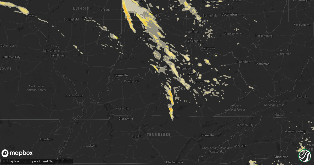
Hail Map in Kentucky on July 13, 2015
Get this storm
July 13 map
$229
one time, instant access
Download today. No call, no setup
Keep the $229
Bought the map and want the full workflow? Apply the entire $229 to a subscription within 7 days. None of it is wasted.
Every map, not just this one
This buys you this map. Subscription and you get every map we run, in the markets you choose from a few cities to whole states to nationwide. Plus real-time alerts the moment a storm fires.
Contact data
Name, contact info, occupancy, even credit band for addresses in the footprint. You go from where it hit to who to call.
Become the source they trust
Unlimited branding weather history reports on demand. You already have the documented answer ready for the property owner, and you are the one who showed up with it.
Property data and RoofTrace estimates
Pull up any address you have got, its value and the exact code rules for that jurisdiction, straight from One Click Code. Then RoofTrace estimates the squares, pitch, and roof value, priced the way you price.
Storm reports in Kentucky
Kentucky
| Date | Description |
|---|---|
| 07/13/20156:53 PM CDT | A local report indicates 1.00 inch wind near 7 SW BURKESVILLE |
| 07/13/20156:42 PM CDT | Numerous trees down across the entire county along with power lines. |
| 07/13/20156:33 PM CDT | A local report indicates 1.00 inch wind near 3 SW MARROWBONE |
| 07/13/20156:32 PM CDT | A local report indicates 2.75 inch wind near 2 SE MARROWBONE |
| 07/13/20156:31 PM CDT | Trees reported down. |
| 07/13/20156:17 PM CDT | Numerous trees down. |
| 07/13/20156:13 PM CDT | Ef0... 0.7 long... 100 yards wide... Destroyed 1 outbuilding and and numerous trees down across sw portion of county |
| 07/13/20155:58 PM CDT | Ef0... 70-80 mph... 1.5 miles long... 35 yards wide... Destroyed 1 outbuilding... Uprooted/snapped trees in breeding... Ky |
| 07/13/20155:40 PM CDT | A local report indicates 1.75 inch wind near 2 E GRADYVILLE |
| 07/13/20155:35 PM CDT | A local report indicates 1.25 inch wind near 3 E BLACK GNAT |
| 07/13/20155:34 PM CDT | Roof blown off a house. |
| 07/13/20155:20 PM CDT | Numerous trees down. |
| 07/13/20155:20 PM CDT | Ef1 95-105 mph... 1.1 miles long... 50 yards wide destroyed 2 barns... 1 mobile home... 6 large outbuildings along ebenezer road and highway 61 |
| 07/13/20155:14 PM CDT | A local report indicates 65 MPH wind near 4 NNW BLACK GNAT |
| 07/13/20155:09 PM CDT | A local report indicates 65 MPH wind near BLACK GNAT |
| 07/13/20155:09 PM CDT | Numerous trees down across the entire county. |
| 07/13/20155:08 PM CDT | A local report indicates 1.75 inch wind near BLACK GNAT |
| 07/13/20155:07 PM CDT | Trees reported down. |
| 07/13/20154:51 PM CDT | A local report indicates 65 MPH wind near 5 WNW SALOMA |
| 07/13/20154:49 PM CDT | Roof blown off a barn and trees down. |
| 07/13/20154:37 PM CDT | Tree reported down. |
| 07/13/20154:28 PM CDT | A local report indicates 1.25 inch wind near RAYWICK |
| 07/13/20154:28 PM CDT | A tree was blown down onto a picnic table. |
| 07/13/20154:23 PM CDT | A tree was uprooted and fell onto a home. |
| 07/13/20154:15 PM CDT | Large tree limbs were blown down. |
| 07/13/20154:15 PM CDT | Multiple large tree limbs down in excess of 3 inches in diameter |
| 07/13/20154:15 PM CDT | Large limbs blown down. |
| 07/13/20154:15 PM CDT | A tree was blown down. |
| 07/13/20154:10 PM CDT | Trees down along ky highway 7 at the perry and letcher county lines. |
| 07/13/20154:04 PM CDT | A tree was blown down onto ky highway 7. |
| 07/13/20154:02 PM CDT | Trees and power lines down on us highway 421. |
| 07/13/20153:58 PM CDT | Tree down. |
| 07/13/20153:57 PM CDT | Several trees were blown down. |
| 07/13/20153:55 PM CDT | Widespread trees down in irvine including the following locations - pea ridge road... Noland creek rd... Spout springs rd... Winston rd... Francis street... Cressy road... Fi |
| 07/13/20153:54 PM CDT | Downed trees |
| 07/13/20153:54 PM CDT | Tree down on mobile home at raney. |
| 07/13/20153:52 PM CDT | Tree and numerous limbs down. |
| 07/13/20153:51 PM CDT | Large limbs blown down. |
| 07/13/20153:50 PM CDT | Tree down across hwy 490. |
| 07/13/20153:50 PM CDT | A tree was blown down. |
| 07/13/20153:49 PM CDT | Trees were reported to have been blown down. |
| 07/13/20153:47 PM CDT | Tree down. |
| 07/13/20153:45 PM CDT | A tree was blown down on a home. |
| 07/13/20153:45 PM CDT | Large tree limbs and a tree were blown down. |
| 07/13/20153:45 PM CDT | Tree and large limbs blocking both lanes. Power lines down. |
| 07/13/20153:35 PM CDT | Several trees down along hwy 292 near the pike county line. |
| 07/13/20153:30 PM CDT | Tree across road. |
| 07/13/20153:25 PM CDT | Large limbs down at the happy church. |
| 07/13/20153:25 PM CDT | Numerous trees... Large limbs and power lines down. |
| 07/13/20153:25 PM CDT | Numerous trees... Large limbs and power lines down. |
| 07/13/20153:23 PM CDT | Tree down on house in the picnic hill subdivision. |
| 07/13/20153:23 PM CDT | Numerous trees and powerlines were blown down. |
| 07/13/20153:20 PM CDT | Downed trees. |
| 07/13/20153:20 PM CDT | Trees down near home off highway 30w. Trees were 15 to 25 feet tall and estimated at around 6 inches in diameter. |
| 07/13/20153:20 PM CDT | Trees were blown down on ky highway 40. |
| 07/13/20153:20 PM CDT | Trees and power lines across hwy 321 near the highland hospital. |
| 07/13/20153:20 PM CDT | Numerous trees down on hwy 30 east. |
| 07/13/20153:18 PM CDT | Tree on house on sand branch rd near ky 828 |
| 07/13/20153:16 PM CDT | A tree was blown down near the vancleve fire dept. |
| 07/13/20153:15 PM CDT | Downed trees. |
| 07/13/20153:15 PM CDT | Trees were reported to have been blown down. |
| 07/13/20153:10 PM CDT | Powerlines were blown down. |
| 07/13/20153:10 PM CDT | Tree on power line on oak st |
| 07/13/20153:01 PM CDT | Tree down on power lines and a house. |
| 07/13/20153:00 PM CDT | Trees and powerlines down throughout lawrence county. Tree on structure off cherryville rd in southern lawrence county. |
| 07/13/20153:00 PM CDT | Tree on house in the louisa city limits. |
| 07/13/20153:00 PM CDT | Trees reported down. |
| 07/13/20152:54 PM CDT | Tree down on mobile home at raney. |
| 07/13/20152:53 PM CDT | Power lines down in the road on north 1st st. |
| 07/13/20152:50 PM CDT | Trees down in the fallsburg area. |
| 07/13/20152:50 PM CDT | Tree down on high st |
| 07/13/20152:48 PM CDT | Tree down on power line on whitlock rd |
| 07/13/20152:41 PM CDT | Tree fell on house. |
| 07/13/20152:40 PM CDT | Trained spotter reports numerous trees down... Power lines and telephone lines down... And a tree on a house with entrapment in the olive hill area |
| 07/13/20152:39 PM CDT | Tree fell on caudill road off of hwy 705. |
| 07/13/20152:32 PM CDT | Tree down in the monticello subdivision on cartier drive. |
| 07/13/20152:30 PM CDT | Numerous trees were blown down county wide. |
| 07/13/20152:28 PM CDT | A shed was destroyed and trees fell at the same residence with one falling onto the home. |
| 07/13/20152:28 PM CDT | Multiple trees across road at horton flat. Has traffic backed up. |
| 07/13/20152:27 PM CDT | Numerous trees down around the city. |
| 07/13/20152:26 PM CDT | Mobile home overturned at the intersection of chase lane and ficklin rd. |
| 07/13/20152:26 PM CDT | Trees down county wide including the following roads- tabor road... Science ridge... Bunker hill... Twin oaks... Nest egg... Cunningham lane... Howards mill... Camargo... And |
| 07/13/20152:24 PM CDT | Pic of tree down in the road at old richmond and s. Cleveland. |
| 07/13/20152:22 PM CDT | Tree down in road at s. Ashland and central |
| 07/13/20152:18 PM CDT | Trees are down. Some traffic lights are without power. |
| 07/13/20152:15 PM CDT | Numerous trees down on hwy 11. |
| 07/13/20152:06 PM CDT | Picture of tree down. |
| 07/13/20152:05 PM CDT | Numerous trees were blown down along cranston road west of morehead. |
| 07/13/20152:00 PM CDT | Downed tree limbs and power lines at garrad park. |
| 07/13/20151:57 PM CDT | Picture of large tree down |
| 07/13/20151:54 PM CDT | Numerous trees down across the city and the entire county along with power lines. |
| 07/13/20151:54 PM CDT | Trees down. |
| 07/13/20151:52 PM CDT | A local report indicates 58 MPH wind near 1 NNE FRANKFORT |
| 07/13/20151:52 PM CDT | Trees down. |
| 07/13/20151:49 PM CDT | Trees down countywide. |
| 07/13/20151:48 PM CDT | Trees down on highway 227 and across the county. |
| 07/13/20151:47 PM CDT | Trees down at old henry and factory lane. |
| 07/13/20151:45 PM CDT | Large limbs and 1 tree down |
| 07/13/20151:45 PM CDT | Wires down at jewish academy. |
| 07/13/20151:45 PM CDT | Trees blown down across the county. |
| 07/13/20151:44 PM CDT | Trees down at river road and glenview. |
| 07/13/20151:44 PM CDT | Picture of tree down near moorefield road |
| 07/13/20151:43 PM CDT | Trees down at brownsboro and moccasin. |
| 07/13/20151:42 PM CDT | Trees reported down. |
| 07/13/20151:41 PM CDT | Tree fell on house. |
| 07/13/20151:41 PM CDT | Tree blocking long run road. |
| 07/13/20151:39 PM CDT | Tree fell on caudill road off of hwy 705. |
| 07/13/20151:38 PM CDT | New roof torn off barn and very large trees down. Time estimated from radar. |
| 07/13/20151:36 PM CDT | Picture of trees and power lines down across north highway 27. |
| 07/13/20151:34 PM CDT | Trees down. |
| 07/13/20151:32 PM CDT | One large tree down. Time estimated from radar. |
| 07/13/20151:30 PM CDT | Trees reported down |
| 07/13/20151:30 PM CDT | Several trees down in maysville due to thunderstorm winds. |
| 07/13/20151:26 PM CDT | Tree limb down on highway 22. |
| 07/13/20151:24 PM CDT | Pic of tree down. |
| 07/13/20151:20 PM CDT | A local report indicates 70 MPH wind near 5 SW AUGUSTA |
| 07/13/20151:16 PM CDT | Tree down near kathy lane and us-27. Time estimated from radar. |
| 07/13/20151:16 PM CDT | Large trees down and portion of roof ripped off structure. Time estimated from radar. |
| 07/13/20151:15 PM CDT | Trees down along route 22 west of dry ridge. |
| 07/13/20151:08 PM CDT | Trees down along route route 127 north of owenton. |
| 07/13/20151:04 PM CDT | Trees down in northern grant county. |
| 07/13/20151:03 PM CDT | Trees down along route 227. |
| 07/13/20151:02 PM CDT | Several large limbs down on house and power lines. Time estimated from radar. |
| 07/13/201512:59 PM CDT | Several 4 to 5 inch diameter branches down and damage to metal barn roof. Time estimated from radar. |
| 07/13/201512:55 PM CDT | Widespread trees down in irvine including the following locations - pea ridge road... Noland creek rd... Spout springs rd... Winston rd... Francis street... Cressy road... Fi |
| 07/13/201512:50 PM CDT | Large tree uprooted along 43rd street. Time estimated from radar. |
| 07/13/201512:45 PM CDT | Numerous limbs and a few trees down across the city. |
| 07/13/201512:44 PM CDT | Large tree down near us-27 and martha lanyne collins blvd. Time estimated from radar. |
| 07/13/201512:41 PM CDT | Large tree uprooted at alanna drive and themla lane. Time estimated from radar. |
| 07/13/201512:40 PM CDT | Tree down due to wind on upland avenue in fort wright. |
| 07/13/201512:39 PM CDT | Multiple trees and limbs down. Time estimated from radar. |
| 07/13/201512:30 PM CDT | Tree and large limbs down in east walnut hills due to wind. |
| 07/13/20156:52 AM CDT | Trees down |
| 07/13/20156:18 AM CDT | Trees down on highway 66. Time estimated from radar. |
| 07/13/20156:11 AM CDT | Tree down on east hwy 92 at mile marker 18 on johnson fork road. |
| 07/13/20156:06 AM CDT | Trees down highway 257. |
| 07/13/20156:05 AM CDT | Trees across the road on hwy 82. |
| 07/13/20156:00 AM CDT | 15 foot diameter tree was uprooted. Section of fence was blown down. |
| 07/13/20155:54 AM CDT | County wide tree damage. |
| 07/13/20155:30 AM CDT | At least 10 trees down... One fell onto the deck of a home. One tree is across hwy 461 blocking traffic on trinity lane. |
| 07/13/20155:24 AM CDT | Dispatch reports trees down county wide. Time estimated from radar. |
| 07/13/20155:20 AM CDT | 2 large trees down in yard. |
| 07/13/20155:13 AM CDT | Trees down over highway 49 and highway 70 in liberty. Other trees reported down across the county. Time estimated from radar. |
| 07/13/20155:08 AM CDT | Trees down at slate lick road and mt. Vernon road. |
| 07/13/20154:54 AM CDT | Multiple trees reported down across garrard county... No reports of structural damage. Time estimated from radar. |
| 07/13/20154:49 AM CDT | Several trees down in the eastern part of jefferson county including on stony brook drive and hurstbourne. |
| 07/13/20154:42 AM CDT | Trees down across county |
| 07/13/20154:40 AM CDT | Measured at the mercer county mesonet. |
| 07/13/20154:38 AM CDT | Tree down. |
| 07/13/20153:47 AM CDT | Trees down on moser road near douglas hills. |
| 07/13/20153:39 AM CDT | Two trees down on honeylore ct. |
| 07/13/20153:15 AM CDT | Trees down on highway 754 west of bedford. |
| 07/13/20152:25 AM CDT | Tree down on hwy 205 in lee city. |
| 07/13/20152:20 AM CDT | Several large trees topped. A cedar tree was mangled and a locust tree was broken off and deposited down a hill. Time estimated from radar. |
| 07/13/20152:20 AM CDT | Multiple trees down including one on a car. |
| 07/13/20152:12 AM CDT | 2 trees broken at 15 feet up and 20 feet up respectively. Estimated 50mph winds. |
| 07/13/20152:04 AM CDT | Tree down in the 5300 block of zaring mill road. Road crews are on scene. |
| 07/13/201512:45 AM CDT | Numerous trees down and reported roof damage. |
| 07/13/201512:45 AM CDT | Trees reported down. |
| 07/13/201512:32 AM CDT | Barns destroyed along us 421. |
| 07/13/201512:30 AM CDT | A local report indicates 70 MPH wind near 3 SW MILTON |
| 07/13/201512:30 AM CDT | A local report indicates 1.75 inch wind near 3 SW MILTON |
| 07/12/20157:18 PM CDT | Ef0 tornado on mon jul 13 moved se out of cumberland county ky into clay county along ashlock road before lifting near highway 53. A few homes had roof damage and sever |
All States Impacted by Hail Map on July 13, 2015
Cities Impacted by Hail Map on July 13, 2015
- Corydon, IN
- McClellanville, SC
- Lineville, IA
- Davis City, IA
- Blythedale, MO
- Templeton, IN
- Oxford, IN
- Holcomb, KS
- Garden City, KS
- Shipshewana, IN
- Millersburg, IN
- Middlebury, IN
- Topeka, IN
- Goshen, IN
- Woodruff, SC
- Delphi, IN
- Knapp, WI
- Glenwood City, WI
- Wilson, WI
- Woodville, WI
- Seneca, IL
- Marseilles, IL
- Troy, NC
- Grand Ridge, IL
- Ottawa, IL
- Vallonia, IN
- Scottsburg, IN
- Salem, IN
- Munster, IN
- Chicago Heights, IL
- Calumet City, IL
- Riverdale, IL
- Gary, IN
- Hammond, IN
- Blue Island, IL
- Hobart, IN
- Highland, IN
- Dolton, IL
- East Chicago, IN
- Markham, IL
- Chicago, IL
- Lansing, IL
- Lake Station, IN
- Griffith, IN
- Harvey, IL
- Whiting, IN
- South Holland, IL
- Thornton, IL
- Turon, KS
- Arlington, KS
- Osseo, WI
- Alma Center, WI
- Hixton, WI
- Prophetstown, IL
- New Bedford, IL
- Tampico, IL
- Walnut, IL
- Lyons, KS
- Nickerson, KS
- Little River, KS
- Inman, KS
- Hutchinson, KS
- Sterling, KS
- Caledonia, IL
- Clinton, WI
- Marengo, IL
- Harvard, IL
- Garden Prairie, IL
- South Beloit, IL
- Poplar Grove, IL
- Capron, IL
- Lafayette, IN
- Campbellsville, KY
- Fort Atkinson, WI
- Cambridge, WI
- Edgerton, WI
- Wheatland, IA
- Grand Mound, IA
- Lowden, IA
- Donahue, IA
- Long Grove, IA
- Calamus, IA
- Petroleum, IN
- Bluffton, IN
- Poneto, IN
- Keystone, IN
- Union City, OH
- Portland, IN
- Union City, IN
- New Weston, OH
- Ansonia, OH
- Lynn, IN
- Winchester, IN
- Fort Recovery, OH
- Ridgeville, IN
- Greenville, OH
- Amery, WI
- Balsam Lake, WI
- South Whitley, IN
- Columbia City, IN
- Larwill, IN
- Tinley Park, IL
- Orland Park, IL
- Mcpherson, KS
- St John, KS
- Great Bend, KS
- Hudson, KS
- Ellinwood, KS
- Schoolcraft, MI
- Cedar Grove, NC
- Westby, WI
- Cashton, WI
- Roberts, IL
- Buckley, IL
- Thawville, IL
- Versailles, KY
- Nicholasville, KY
- Creola, OH
- Mooresburg, TN
- Thorn Hill, TN
- Lancaster, SC
- Catawba, SC
- Ravenna, KY
- Clay City, KY
- Lakin, KS
- Vanceburg, KY
- Cimarron, KS
- Huntington, IN
- Williamsport, IN
- West Lebanon, IN
- Covington, IN
- Veedersburg, IN
- Kingman, IN
- Sparta, WI
- Rockland, WI
- Bangor, WI
- West Salem, WI
- Allerton, IA
- Corydon, IA
- New Era, MI
- Montague, MI
- Cedar Lake, IN
- Crown Point, IN
- Saint John, IN
- Schererville, IN
- Greensburg, KY
- New London, WI
- Camden, IN
- Newton, IL
- Ingraham, IL
- Mattoon, IL
- Charleston, IL
- Humboldt, IL
- Whitehall, WI
- Taylor, WI
- Blair, WI
- Strawn, IL
- Chatsworth, IL
- Spartanburg, SC
- Chesnee, SC
- Brooklyn, MI
- Onsted, MI
- Aurora, IL
- Willowbrook, IL
- Downers Grove, IL
- Bolingbrook, IL
- Lemont, IL
- Darien, IL
- Naperville, IL
- Woodridge, IL
- Lisle, IL
- Leslie, GA
- Geneseo, IL
- Buckner, KY
- La Grange, KY
- Paris, KY
- Celina, TN
- Hope, KS
- Gypsum, KS
- Sneedville, TN
- Blackwater, VA
- Kyles Ford, TN
- Jonesville, VA
- Lima, OH
- Leesburg, IN
- Milton, KY
- Bedford, KY
- Hanover, IN
- Herscher, IL
- Paynesville, WV
- Edinburgh, IN
- Columbus, IN
- Edmonton, KY
- Burkesville, KY
- Le Claire, IA
- Port Byron, IL
- Kirksville, MO
- Brashear, MO
- Novinger, MO
- Greentop, MO
- Queen City, MO
- Wellington, MO
- Germanton, NC
- Walnut Cove, NC
- Fort Mill, SC
- Rock Hill, SC
- Portage, WI
- Poynette, WI
- Winnsboro, SC
- Ridgeway, SC
- Dodge, WI
- La Crosse, WI
- Trempealeau, WI
- Viola, WI
- Onalaska, WI
- Holmen, WI
- Coon Valley, WI
- Fountain City, WI
- La Farge, WI
- Winona, MN
- Galesville, WI
- Arcadia, WI
- Richmond, KY
- Winchester, KY
- Lexington, KY
- Merrillville, IN
- Newton, KS
- North Newton, KS
- Bucklin, KS
- Ivanhoe, NC
- Harrells, NC
- Humboldt, NE
- Dunnellon, FL
- Great Falls, SC
- Galva, KS
- Rossville, IN
- Frankfort, IN
- Cutler, IN
- Lawrenceburg, KY
- Alden, KS
- Whitmire, SC
- Brooklyn, WI
- Marysville, OH
- Raymond, OH
- Richwood, OH
- Romeoville, IL
- Crest Hill, IL
- Lockport, IL
- Irvine, KY
- Winamac, IN
- Monterey, IN
- Martinsville, IN
- Mooers Forks, NY
- Commiskey, IN
- Paris Crossing, IN
- Atkinson, IL
- Cambridge, IL
- Shelbyville, KY
- Bagdad, KY
- Farmland, IN
- Bloomington, IN
- Camden, SC
- Lugoff, SC
- Elizabethtown, KY
- Valparaiso, IN
- Stockland, IL
- Bloomingdale, IN
- Kentland, IN
- Bridgeton, IN
- Knightsville, IN
- Centerpoint, IN
- Sheldon, IL
- Brazil, IN
- Wellington, IL
- Reelsville, IN
- Earl Park, IN
- Fowler, IN
- Harmony, IN
- Watseka, IL
- Rockville, IN
- Milford, IL
- Rosedale, IN
- Hoopeston, IL
- Ambia, IN
- Montezuma, IN
- Marshall, IN
- Carbon, IN
- Elmer, MO
- Ethel, MO
- New Boston, MO
- Cochrane, WI
- Fulton, MI
- Mendon, MI
- Oak Grove, MO
- Wyanet, IL
- Ottawa, KS
- Lorraine, KS
- Geneseo, KS
- Cambridge City, IN
- Youngstown, FL
- Urbana, OH
- De Graff, OH
- Merrimac, WI
- Stamping Ground, KY
- Lexington, NC
- Ravenwood, MO
- Maryville, MO
- Bethany, MO
- Sheridan, MO
- Ridgeway, MO
- Denver, MO
- Gentry, MO
- Albany, MO
- New Hampton, MO
- Worth, MO
- Martinsville, MO
- Burlington Junction, MO
- Hopkins, MO
- Pickering, MO
- Tarkio, MO
- Parnell, MO
- Eagleville, MO
- Baraboo, WI
- Rio, WI
- Paola, KS
- Fontana, KS
- Osawatomie, KS
- La Cygne, KS
- Waupaca, WI
- Hazel Crest, IL
- Midlothian, IL
- Oak Forest, IL
- Country Club Hills, IL
- Wilmington, NC
- Castle Hayne, NC
- Seymour, WI
- Rochester, IN
- Francesville, IN
- Asheboro, NC
- Sutherlin, VA
- Ringgold, VA
- Arlington, WI
- Harrodsburg, KY
- Krypton, KY
- Busy, KY
- Pembroke, NC
- Lumberton, NC
- Elon, NC
- Milton, NC
- Providence, NC
- Yanceyville, NC
- Mebane, NC
- Blanch, NC
- Burlington, NC
- Mount Vernon, KY
- Berea, KY
- Tyner, KY
- Vincent, KY
- Wellington, KY
- Campton, KY
- Pennville, IN
- Kewanee, IL
- Monroeville, IN
- Nineveh, IN
- Nashville, IN
- Moore Haven, FL
- Vienna, GA
- Muskegon, MI
- Twin Lake, MI
- Clarence, IA
- Spickard, MO
- Galt, MO
- Humphreys, MO
- Princeton, MO
- Milan, MO
- Mount Pleasant, SC
- Awendaw, SC
- Adrian, GA
- Utica, IL
- Syracuse, IN
- Ligonier, IN
- Delmar, IA
- Oxford Junction, IA
- Lost Nation, IA
- De Witt, IA
- Morgantown, IN
- Sparland, IL
- Russell Springs, KY
- Dunnville, KY
- Hanston, KS
- Larned, KS
- Green Bay, WI
- Bristol, IN
- Luck, WI
- Centuria, WI
- Cushing, WI
- Milltown, WI
- Monrovia, IN
- New Hope, KY
- Raywick, KY
- La Grange, IL
- Berwyn, IL
- Arcanum, OH
- Orlando, KY
- Crab Orchard, KY
- Brodhead, KY
- Strum, WI
- Fairchild, WI
- Jackson, KY
- Salyersville, KY
- Rousseau, KY
- Ford, KS
- Wilmington, IL
- Bonfield, IL
- Essex, IL
- Braceville, IL
- Braidwood, IL
- Ellsworth, KS
- Kanopolis, KS
- Pawnee Rock, KS
- Decatur, MI
- Lawrence, MI
- Paw Paw, MI
- Hartford, MI
- Wilmington, OH
- New Vienna, OH
- Whitehall, MI
- Kankakee, IL
- Overbrook, KS
- Carbondale, KS
- Martinsville, IL
- West Union, IL
- West York, IL
- Leland, NC
- Whitewater, KS
- Elbing, KS
- El Dorado, KS
- Cassoday, KS
- Burns, KS
- Potwin, KS
- Robinson, IL
- Hillsboro, OH
- Midland, OH
- Lynchburg, OH
- Martinsville, OH
- Englewood, OH
- Abbyville, KS
- Concord, VA
- North Troy, VT
- Newport Center, VT
- Newport, VT
- Verona, IL
- Salamonia, IN
- Dayton, OH
- Ash, NC
- Ocean Isle Beach, NC
- Scottville, MI
- Ludington, MI
- Neponset, IL
- Eutawville, SC
- Viroqua, WI
- Readstown, WI
- Smithville, GA
- De Soto, GA
- Elizabethton, TN
- Hampton, TN
- Butler, TN
- Dunkirk, IN
- McKee, KY
- Annville, KY
- Booneville, KY
- Danville, VA
- Claxton, GA
- Cobbtown, GA
- Collins, GA
- Kewaunee, WI
- Algoma, WI
- Casco, WI
- Zanesfield, OH
- Bellefontaine, OH
- Galien, MI
- New Buffalo, MI
- Rolling Prairie, IN
- La Porte, IN
- New Carlisle, IN
- Three Oaks, MI
- Cynthiana, KY
- Albion, IN
- Kimmell, IN
- Beattyville, KY
- Cainsville, MO
- Madison, WI
- Waunakee, WI
- Newaygo, MI
- Somerset, OH
- Seymour, IN
- Sullivan, IL
- Douglas, AZ
- Tiskilwa, IL
- Princeton, IL
- Shiocton, WI
- Black River Falls, WI
- Mondovi, WI
- Durand, WI
- Melrose, WI
- Menomonie, WI
- Fall Creek, WI
- Eau Claire, WI
- Eleva, WI
- Janesville, WI
- Kouts, IN
- Saint Croix Falls, WI
- Roanoke, IN
- Yoder, IN
- Fort Wayne, IN
- Warsaw, IN
- Milford, IN
- Hyde Park, VT
- Morrisville, VT
- Johnson City, TN
- Beverly, KS
- Manteno, IL
- Bourbonnais, IL
- Buckhorn, KY
- Gays Creek, KY
- Union, IL
- Champlain, NY
- West Chazy, NY
- Chazy, NY
- Longwood, NC
- Sunset Beach, NC
- Clayton, OH
- Brookville, OH
- Muncie, IN
- Bluff City, TN
- Egg Harbor, WI
- Modoc, IN
- Avon, IN
- Darlington, SC
- Inman, SC
- Bolton, NC
- Procious, WV
- Crestwood, KY
- Lone Rock, WI
- Avoca, WI
- Spring Green, WI
- Ridgeway, WI
- Arena, WI
- Richland Center, WI
- Dodgeville, WI
- Sister Bay, WI
- Mercer, MO
- Berne, IN
- Montpelier, IN
- Hartford City, IN
- Geneva, IN
- Bryant, IN
- New Middletown, IN
- Elizabeth, IN
- New London, NC
- Albemarle, NC
- Elkhart, IN
- Casa Blanca, NM
- Ingalls, KS
- Jetmore, KS
- Belvidere, IL
- Huntertown, IN
- Churubusco, IN
- Laotto, IN
- Green City, MO
- Rutledge, MO
- Worthington, MO
- Memphis, MO
- Green Castle, MO
- Baring, MO
- Pollock, MO
- Edina, MO
- Knox City, MO
- Unionville, MO
- Downing, MO
- Lewistown, MO
- Canton, MO
- La Grange, MO
- Monticello, MO
- Willisburg, KY
- Wausau, WI
- Merrill, WI
- Antigo, WI
- Moncks Corner, SC
- Milwaukee, WI
- Montezuma, KS
- Battle Creek, MI
- Ceresco, MI
- Burgaw, NC
- Willard, NC
- Seymour, IA
- Mattoon, WI
- New Franken, WI
- Boiling Springs, SC
- Centreville, MI
- Three Rivers, MI
- Sturgis, MI
- Petersburg, VA
- Campobello, SC
- Wellford, SC
- Moore, SC
- Long Creek, OR
- Anderson, IN
- Saint Henry, OH
- Portage, IN
- Leonidas, MI
- Vicksburg, MI
- Columbia, KY
- Marcellus, MI
- Browns Summit, NC
- Gibsonville, NC
- Vancleve, KY
- Frenchburg, KY
- Slade, KY
- East Bend, NC
- Bourbon, IN
- Plymouth, IN
- Grant, MI
- Ravenna, MI
- Nancy, KY
- Gardner, IL
- Buckingham, IL
- Reddick, IL
- Chebanse, IL
- North Vernon, IN
- Allons, TN
- Hilham, TN
- Bardstown, KY
- Coxs Creek, KY
- Birnamwood, WI
- Aniwa, WI
- Bloomfield, KY
- Austin, IN
- Freetown, IN
- Eidson, TN
- New Liberty, KY
- Owenton, KY
- Corinth, KY
- Simpsonville, KY
- Waddy, KY
- Mount Eden, KY
- Louisville, KY
- Fisherville, KY
- Finchville, KY
- Chaplin, KY
- Taylorsville, KY
- Otisco, IN
- Underwood, IN
- Marysville, IN
- Glencoe, KY
- Warsaw, KY
- Wild Rose, WI
- Pine River, WI
- Redgranite, WI
- Fayetteville, NC
- Westmont, IL
- New Paris, OH
- Mayesville, SC
- Rocky Point, NC
- Frankfort, KY
- Supply, NC
- Whitestown, IN
- Zionsville, IN
- Richmond Hill, GA
- Saltville, VA
- Somerset, KY
- Rockford, MI
- Belmont, MI
- Ada, MI
- Lake Placid, FL
- Spencer, IN
- Burnettsville, IN
- Star City, IN
- Royal Center, IN
- Idaville, IN
- Monticello, IN
- Logansport, IN
- Pageland, SC
- Marshville, NC
- Blountville, TN
- Kingsport, TN
- West Lafayette, IN
- New Ross, IN
- Crawfordsville, IN
- Hillsboro, IN
- Colfax, IN
- Romney, IN
- Thorntown, IN
- New Richmond, IN
- Pine Village, IN
- Attica, IN
- Linden, IN
- Wingate, IN
- Lebanon, IN
- Darlington, IN
- Mellott, IN
- Ladoga, IN
- Boswell, IN
- Otterbein, IN
- Westpoint, IN
- Waynetown, IN
- Newtown, IN
- Jamestown, IN
- Mayview, MO
- Ossian, IN
- Lynchburg, VA
- Wheeler, WI
- Donovan, IL
- Clifton, IL
- Papineau, IL
- Saint Anne, IL
- Beaverville, IL
- Martinton, IL
- Cabery, IL
- Hardinsburg, IN
- Fredericksburg, IN
- Chase, KS
- Star, NC
- Annawan, IL
- Grantsburg, WI
- Piper City, IL
- Blythewood, SC
- East Moline, IL
- Rapids City, IL
- Bettendorf, IA
- Cordova, IL
- Hillsdale, IL
- Eldridge, IA
- Davenport, IA
- Princeton, IA
- McCausland, IA
- Tollesboro, KY
- Plevna, KS
- Odell, IL
- Hodgenville, KY
- Buda, IL
- Bradford, IL
- Cecil, WI
- South Bend, IN
- Green Sea, SC
- Bladenboro, NC
- Roodhouse, IL
- Winchester, IL
- Cullom, IL
- Saunemin, IL
- Shepherdsville, KY
- Coatesville, IN
- Stilesville, IN
- Mooresville, IN
- Clayton, IN
- Plainfield, IN
- Danville, IN
- Ramsey, IN
- Copeland, KS
- Colon, MI
- Allegan, MI
- Hopkins, MI
- Mount Olive, NC
- Decatur, IL
- Cassopolis, MI
- Jones, MI
- Vandalia, MI
- Clio, SC
- Bradford, OH
- Clayhole, KY
- Lost Creek, KY
- Borden, IN
- Pekin, IN
- Emington, IL
- Covington, OH
- Baileys Harbor, WI
- Akron, IN
- Clarks Hill, IN
- Ramseur, NC
- Franklinville, NC
- Staley, NC
- Dowagiac, MI
- Jackson, OH
- Fillmore, IN
- Cloverdale, IN
- Quincy, IN
- Cottage Grove, WI
- Clarendon Hills, IL
- Alton, VA
- Brownstown, IN
- Newark, MO
- La Belle, MO
- Ewing, MO
- Ohio City, OH
- Van Wert, OH
- Matewan, WV
- Wharncliffe, WV
- Deerfield, KS
- Dillon, SC
- Wyoming, IL
- Soldiers Grove, WI
- Yale, IL
- Oblong, IL
- Medaryville, IN
- North Judson, IN
- Gravel Switch, KY
- Lebanon, KY
- Carlinville, IL
- Hettick, IL
- Kewanna, IN
- Charlestown, IN
- North Charleston, SC
- Ladson, SC
- Scott City, KS
- Laurelville, OH
- Kingston, OH
- Winigan, MO
- Middle Point, OH
- Hampton, IL
- Colona, IL
- Camanche, IA
- Kingman, KS
- Buffalo, KY
- New Haven, KY
- Mount Sherman, KY
- Summersville, KY
- Milltown, IN
- Depauw, IN
- Georgetown, IN
- Brooks, KY
- Laconia, IN
- New Salisbury, IN
- Crandall, IN
- Fairdale, KY
- Lanesville, IN
- New Albany, IN
- Kirklin, IN
- Kempton, IN
- Sheridan, IN
- Michigantown, IN
- Marion, IN
- Van Buren, IN
- Roachdale, IN
- Bainbridge, IN
- Amo, IN
- North Salem, IN
- Randolph, VA
- Brookneal, VA
- Charlotte Court House, VA
- Phenix, VA
- Saxe, VA
- Sanderson, FL
- Arcadia, FL
- Cicero, IN
- Arcadia, IN
- Atlanta, IN
- Waukesha, WI
- Delafield, WI
- Nashotah, WI
- Hartland, WI
- Pewaukee, WI
- Bluffs, IL
- Prestonsburg, KY
- Whiteville, NC
- Windom, KS
- Chesterton, IN
- Penhook, VA
- Americus, GA
- Red House, VA
- Longs, SC
- Loris, SC
- Olive Hill, KY
- Morehead, KY
- Mooers, NY
- Altona, NY
- Moorefield, KY
- Mayslick, KY
- Flemingsburg, KY
- Mount Olivet, KY
- Ewing, KY
- Carlisle, KY
- Greenville, IL
- Yorkville, IL
- Dry Ridge, KY
- Jonesville, KY
- McCarr, KY
- Stopover, KY
- Freeburn, KY
- Majestic, KY
- Macon, IL
- Dalton City, IL
- Dwight, IL
- Mazon, IL
- Kempton, IL
- Ransom, IL
- Campus, IL
- Kinsman, IL
- Plainfield, WI
- Almond, WI
- Plover, WI
- Bancroft, WI
- Wisconsin Rapids, WI
- Amherst, WI
- Bellbrook, OH
- Spring Valley, OH
- Xenia, OH
- Miamisburg, OH
- Waynesville, OH
- Springboro, OH
- Berryton, KS
- McBee, SC
- Dupont, IN
- Madison, IN
- Beloit, WI
- Woodstock, IL
- Gate City, VA
- Church Hill, TN
- Wingate, NC
- Monroe, NC
- Daleville, AL
- Johnson, NE
- Tecumseh, NE
- Lawrence, NE
- Shady Valley, TN
- Metter, GA
- Register, GA
- Sorento, IL
- Welch, WV
- Anawalt, WV
- Mozelle, KY
- Warbranch, KY
- Cubero, NM
- Pueblo Of Acoma, NM
- Rogersville, TN
- Bringhurst, IN
- Flora, IN
- Homewood, IL
- Quincy, IL
- Liberty Hill, SC
- Hazel Green, KY
- Clarkton, NC
- Florence, SC
- Wisconsin Dells, WI
- Berry, KY
- Needham, IN
- Stinnett, KY
- Hyden, KY
- Gays, IL
- Elburn, IL
- Sugar Grove, IL
- Monmouth, IA
- Wyoming, IA
- Campbellsburg, IN
- Bowling Green, IN
- Poland, IN
- Currie, NC
- Churubusco, NY
- Sublette, KS
- Claypool, IN
- Pierceton, IN
- Jackson Center, OH
- Maplewood, OH
- Stanford, KY
- Junction City, KY
- Salvisa, KY
- Pewee Valley, KY
- Mackville, KY
- Danville, KY
- Perryville, KY
- Lancaster, KY
- Brookville, KS
- Upland, IN
- Baldwin City, KS
- Lawrence, KS
- Wakarusa, KS
- Yorktown, IN
- Daleville, IN
- La Salle, IL
- Harts, WV
- Matfield Green, KS
- Sandgap, KY
- Gladstone, VA
- Lamar, SC
- Independence, WI
- Sheffield, IL
- Lucerne, MO
- White Cloud, MI
- West Liberty, KY
- Buhler, KS
- Goshen, OH
- Pleasant Plain, OH
- New Glarus, WI
- Belleville, WI
- Piney Flats, TN
- Niles, MI
- Buchanan, MI
- Greeneville, TN
- Parrottsville, TN
- Crete, IL
- Dyer, IN
- Wilmore, KY
- Oneida, WI
- Black Creek, WI
- Lexington, NE
- New Lenox, IL
- Mokena, IL
- Homer Glen, IL
- Beech Grove, IN
- Indianapolis, IN
- Union, MI
- White Pigeon, MI
- Fedscreek, KY
- Steele, KY
- Topeka, KS
- Sumner, IL
- Tomah, WI
- Elwood, IL
- Morris, IL
- Newark, IL
- Minooka, IL
- Shorewood, IL
- Joliet, IL
- Channahon, IL
- Manhattan, IL
- Palestine, IL
- Carlisle, IN
- Harrison, OH
- West Harrison, IN
- Lawrenceburg, IN
- Nunica, MI
- Coopersville, MI
- Fruitport, MI
- Pierceville, KS
- Kent City, MI
- Harris, MO
- Ursa, IL
- Newtown, MO
- Durham, MO
- Hurdland, MO
- Maywood, MO
- Williamstown, MO
- Mill Creek, IN
- Hinckley, IL
- Hampstead, NC
- Casey, IL
- Blanchester, OH
- Clarksville, OH
- Delbarton, WV
- Dodge City, KS
- Alto, MI
- Randleman, NC
- Climax, NC
- Deer Grove, IL
- Appomattox, VA
- Waynesburg, KY
- Crivitz, WI
- Elgin, SC
- Tabor City, NC
- Cherry Valley, IL
- Covington, KY
- Bedford, VA
- Knifley, KY
- Greenfield, IL
- Skidmore, MO
- Fairfax, MO
- Ellettsville, IN
- Gosport, IN
- Clifford, IN
- Hope, IN
- Taylorsville, IN
- Rossburg, OH
- Verona, KY
- London, KY
- Floyds Knobs, IN
- Montgomery Center, VT
- Wellsville, KS
- Rantoul, KS
- Grand Rapids, MI
- Plainwell, MI
- Martin, MI
- Otsego, MI
- Markle, IN
- Warren, IN
- Barneveld, WI
- Mount Horeb, WI
- Hillsboro, WI
- Genoa, WI
- Hillpoint, WI
- Blue Mounds, WI
- Gradyville, KY
- Magnolia, KY
- Breeding, KY
- Tompkinsville, KY
- Startex, SC
- Duncan, SC
- Gas City, IN
- Jonesboro, IN
- Fairmount, IN
- Loda, IL
- Radnor, OH
- Tazewell, TN
- Ludlow Falls, OH
- Redkey, IN
- Pleasant Hill, OH
- Laura, OH
- Pitsburg, OH
- West Milton, OH
- Phillipsburg, OH
- Tipp City, OH
- Vandalia, OH
- Gettysburg, OH
- Versailles, OH
- Salt Lick, KY
- Ness City, KS
- Sadieville, KY
- Warrensburg, MO
- Charlotte, NC
- Waxhaw, NC
- Posen, IL
- Columbus, WI
- Lagrange, IN
- Howe, IN
- Pendleton, IN
- Wilkinson, IN
- Greenfield, IN
- Humeston, IA
- Keyesport, IL
- Monroe, VA
- Madison Heights, VA
- Ezel, KY
- Canaan, IN
- Butlerville, IN
- Nabb, IN
- Lexington, IN
- Deputy, IN
- Deforest, WI
- Hutsonville, IL
- Lizton, IN
- Norman, IN
- Medora, IN
- Bedford, IN
- Heltonville, IN
- Greenwood, IN
- Franklin, IN
- Whiteland, IN
- Leon, IA
- Forest, VA
- Oshkosh, WI
- Amelia, OH
- New Richmond, OH
- Lerna, IL
- Caledonia, MI
- Fountain, FL
- Syracuse, KS
- Kendallville, IN
- Leo, IN
- Auburn, IN
- Pendleton, KY
- Bethlehem, IN
- New Washington, IN
- Buckingham, VA
- Blenheim, SC
- Bennettsville, SC
- Cedar Bluff, VA
- Honaker, VA
- Sandoval, IL
- Carlyle, IL
- Parker, KS
- Lodi, WI
- Sauk City, WI
- Dane, WI
- Cross Plains, WI
- Jamestown, OH
- Port William, OH
- Clear Lake, WI
- Prospect, KY
- Goshen, KY
- Uniondale, IN
- Craigville, IN
- Dover, KY
- Hamlin, WV
- Woodstock, OH
- Milford Center, OH
- Bradfordsville, KY
- New Castle, KY
- Pleasureville, KY
- Campbellsburg, KY
- Sulphur, KY
- La Fontaine, IN
- Wheeler, IL
- Dillsboro, IN
- Bennington, IN
- Rising Sun, IN
- Georgetown, KY
- Maquoketa, IA
- Baldwin, IA
- Greenup, IL
- Arrington, VA
- Lynchburg, SC
- Lexington, MO
- Odessa, MO
- Fremont, MI
- Holton, MI
- Rosewood, OH
- Saint Paris, OH
- Conover, OH
- West Liberty, OH
- Eubank, KY
- Peru, IN
- Liberty Center, IN
- Wright, KS
- Clarendon, NC
- Nathalie, VA
- Denton, NC
- Nichols, SC
- Lamoni, IA
- Kellerton, IA
- Cable, OH
- North Lewisburg, OH
- Pineville, NC
- Cross, SC
- Suamico, WI
- Luxemburg, WI
- Little Suamico, WI
- Galva, IL
- Pleasant Valley, IA
- Erie, IL
- Chillicothe, IL
- Toulon, IL
- Athelstane, WI
- Belding, MI
- Saranac, MI
- Lowell, MI
- Alexandria, KY
- Moundridge, KS
- Rustburg, VA
- Hazard, KY
- Rowdy, KY
- Harbert, MI
- Sawyer, MI
- Bridgman, MI
- Trinity, NC
- Sophia, NC
- High Point, NC
- Monee, IL
- Frankfort, IL
- Huger, SC
- Sandwich, IL
- Matthews, IN
- Silver City, IA
- Mount Sterling, KY
- Delton, MI
- Pratt, KS
- Altura, MN
- Alma, WI
- Neoga, IL
- Palmyra, IN
- Greenville, IN
- Griggsville, IL
- Liberty, IL
- Barry, IL
- Baylis, IL
- Vevay, IN
- Abingdon, VA
- Marion, VA
- Myrtle Beach, SC
- Camp Douglas, WI
- Charleston, SC
- Boyceville, WI
- Richland, MI
- Hickory Corners, MI
- Constantine, MI
- Orleans, MI
- Bishopville, SC
- Webbville, KY
- Grayson, KY
- Sandy Hook, KY
- Mentone, IN
- Lucerne, IN
- Wooton, KY
- Reidsville, NC
- Oswego, IL
- Union, SC
- Enoree, SC
- Olin, IA
- Elkfork, KY
- Flatgap, KY
- Piqua, OH
- Bethune, SC
- Clover, VA
- Drakes Branch, VA
- Gladys, VA
- Decatur, IA
- Little Rock, SC
- Windsor, KY
- Bangor, MI
- Covert, MI
- Milton, IN
- Dunlow, WV
- Partridge, KS
- Pittsboro, IN
- Boggstown, IN
- Brooklyn, IN
- Shelbyville, IN
- Brownsburg, IN
- Lockport, KY
- Roanoke, VA
- Muir, MI
- Ionia, MI
- Fenwick, MI
- Williamsburg, OH
- Mount Orab, OH
- Ostrander, OH
- Atkinson, NC
- Lane, KS
- Pomona, KS
- Boston, KY
- Lebanon Junction, KY
- Hartsville, SC
- Manchester, KY
- Brookfield, WI
- Elm Grove, WI
- Westfield, IL
- Omro, WI
- Greensboro, NC
- East Liberty, OH
- Kirkland, IL
- Clare, IL
- Hesperia, MI
- Sanders, KY
- Sparta, KY
- York, SC
- Wabash, IN
- Avalon, WI
- Darien, WI
- Sharon, WI
- Walworth, WI
- Swainsboro, GA
- Soperton, GA
- Kite, GA
- North Manchester, IN
- Sheridan, IL
- Millington, IL
- Serena, IL
- Pounding Mill, VA
- Jonesborough, TN
- Dillwyn, VA
- Howardsville, VA
- Hallsboro, NC
- North Myrtle Beach, SC
- Calabash, NC
- Shallotte, NC
- Delco, NC
- Lake Waccamaw, NC
- Bolivia, NC
- Little River, SC
- Nakina, NC
- Winnabow, NC
- Marengo, IN
- Whitley City, KY
- Carrollton, KY
- Turners Station, KY
- Corbin, KY
- Oneida, KY
- Ricetown, KY
- Mistletoe, KY
- Rothbury, MI
- Germantown, OH
- Arthur, IL
- Corning, OH
- Colfax, WI
- New Palestine, IN
- South Bloomingville, OH
- Goose Creek, SC
- Hope Mills, NC
- Hamilton, OH
- Paoli, IN
- Thornville, OH
- Scott, OH
- Yellow Springs, OH
- Lick Creek, KY
- Harrogate, TN
- Wonewoc, WI
- Delavan, WI
- Sheboygan, WI
- Byron Center, MI
- Owingsville, KY
- Onslow, IA
- Wapakoneta, OH
- Spencerville, OH
- Wawaka, IN
- New Paris, IN
- North Webster, IN
- Winona Lake, IN
- Silver Lake, IN
- Nappanee, IN
- Cromwell, IN
- Edwardsburg, MI
- Avilla, IN
- Etna Green, IN
- New Castle, IN
- Hagerstown, IN
- Mooreland, IN
- Hubbardston, MI
- Carson City, MI
- Delaware, OH
- Norwalk, WI
- Osco, IL
- Liberty, NC
- Andrews, IN
- Lagro, IN
- Urbana, IN
- Stanton, KY
- Jeffersonville, IN
- Masonic Home, KY
- Palos Heights, IL
- Warrenville, IL
- North Aurora, IL
- Wheaton, IL
- Crestwood, IL
- Robbins, IL
- Willow Springs, IL
- Palos Park, IL
- Glen Ellyn, IL
- Alsip, IL
- Evergreen Park, IL
- Convoy, OH
- Lovington, IL
- Barnard, MO
- Lake In The Hills, IL
- Crystal Lake, IL
- Algonquin, IL
- Huntley, IL
- Flat Rock, IL
- Manning, SC
- Conklin, MI
- Eaton, IN
- La Crosse, IN
- Reidsville, GA
- Raymond, KS
- Fort Stewart, GA
- Clewiston, FL
- Lake City, SC
- Shirley, IN
- Waco, KY
- Huntersville, NC
- Davidson, NC
- Vincennes, IN
- Necedah, WI
- New Lisbon, WI
- Lawrenceville, IL
- Cincinnati, OH
- Comstock Park, MI
- Sparta, MI
- Alkol, WV
- Fairmont, NC
- Livingston, KY
- Pilot Mountain, NC
- Versailles, IN
- Bear Creek, WI
- Lewistown, OH
- Callands, VA
- Axton, VA
- Auburn, NE
- Deerfield, WI
- Alcolu, SC
- Quincy, OH
- Sidney, OH
- Sextons Creek, KY
- Fulton, IL
- Harmon, IL
- Rock Falls, IL
- Fenton, IL
- Lyndon, IL
- Fayetteville, OH
- Ceres, VA
- Mcconnelsville, OH
- Blue Rock, OH
- Lyons, GA
- Zoe, KY
- Kiahsville, WV
- Ranger, WV
- South Hutchinson, KS
- Springfield, KY
- Hillsdale, IN
- Crothersville, IN
- Camby, IN
- Forrest, IL
- Westport, KY
- Scipio, IN
- Onarga, IL
- Jonesville, IN
- New Market, IN
- Elizabethtown, IN
- Coal City, IL
- Smithfield, KY
- Pontiac, IL
- Advance, IN
- Paragon, IN
- Flat Rock, IN
- Waveland, IN
- Perrysville, IN
- Gilman, IL
- Hartsville, IN
- Memphis, IN
- Henryville, IN
- Fairland, IN
- Trafalgar, IN
- Melvin, IL
- Bargersville, IN
- Carmel, IN
- Aroma Park, IL
- Mineral, IL
- Greensburg, IN
- Coldwater, OH
- Spring Lake, MI
- Annapolis, IL
- Sun Prairie, WI
- Marshall, WI
- Burrton, KS
- Kelly, NC
- Elizabethtown, NC
- Blue Ridge, VA
- Noblesville, IN
- Spencerville, IN
- Grabill, IN
- Elk Horn, KY
- Eminence, KY
- Iaeger, WV
- Lehigh Acres, FL
- Bonduel, WI
- Staffordsville, KY
- Wittensville, KY
- Sitka, KY
- Paintsville, KY
- West Alexandria, OH
- New Lebanon, OH
- Farmersville, OH
- Camden, OH
- Wallace, MI
- Ephraim, WI
- Menominee, MI
- Fish Creek, WI
- Ellison Bay, WI
- Sturgeon Bay, WI
- Summerton, SC
- Falun, KS
- Peru, IL
- Dalzell, IL
- Spring Valley, IL
- Williamstown, KY
- Ghent, KY
- Durham, KS
- Pawnee City, NE
- Arcadia, SC
- Una, SC
- Pauline, SC
- Jonesville, SC
- Lyman, SC
- Roebuck, SC
- Batavia, OH
- Milford, OH
- Clearmont, MO
- Henrietta, MO
- Humbird, WI
- Cowpens, SC
- Marshall, IL


