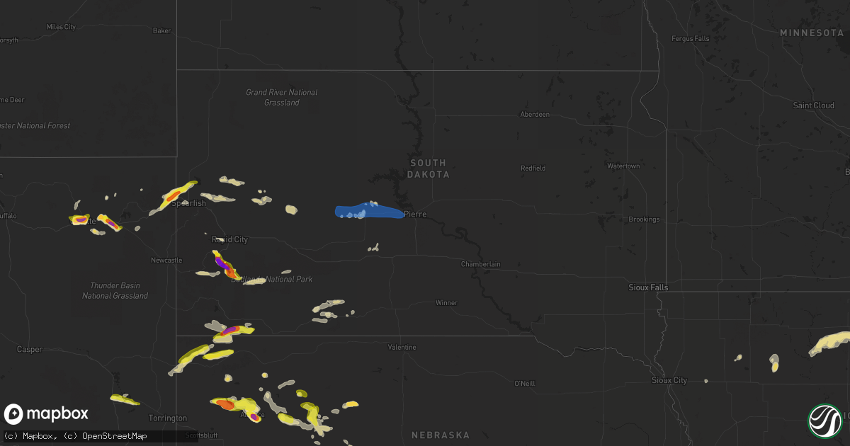
Hail Map in South Dakota on July 9, 2020
Get this storm
July 9 map
$229
one time, instant access
Download today. No call, no setup
Keep the $229
Bought the map and want the full workflow? Apply the entire $229 to a subscription within 7 days. None of it is wasted.
Every map, not just this one
This buys you this map. Subscription and you get every map we run, in the markets you choose from a few cities to whole states to nationwide. Plus real-time alerts the moment a storm fires.
Contact data
Name, contact info, occupancy, even credit band for addresses in the footprint. You go from where it hit to who to call.
Become the source they trust
Unlimited branding weather history reports on demand. You already have the documented answer ready for the property owner, and you are the one who showed up with it.
Property data and RoofTrace estimates
Pull up any address you have got, its value and the exact code rules for that jurisdiction, straight from One Click Code. Then RoofTrace estimates the squares, pitch, and roof value, priced the way you price.
Storm reports in South Dakota
South Dakota
| Date | Description |
|---|---|
| 07/09/20205:45 PM CDT | A local report indicates 1.25 inch wind near 3 SE FAIRBURN |
| 07/09/20205:22 PM CDT | A local report indicates 1.50 inch wind near 6 SW HERMOSA |
| 07/09/20205:22 PM CDT | Hail began at 422 pm... And is still hailing. |
| 07/09/20204:56 PM CDT | Mostly ping pong ball to golfball size... Some up to baseball size |
| 07/09/20204:50 PM CDT | 1.5 inch to 2.5 inch hail |
| 07/09/20204:40 PM CDT | A local report indicates 1.50 inch wind near MOUNT RUSHMORE |
| 07/09/20207:41 AM CDT | At 1241 AM MDT, a severe thunderstorm was located 6 miles north of Scenic, or 39 miles east of Rapid City, moving east at 25 mph. HAZARD...Quarter size hail. SOURCE...Radar indicated. IMPACT...Damage to vehicles is expected. This severe thunderstorm will be near... Northern Badlands National Park around 1255 AM MDT. Pinnacles Ranger Station around 110 AM MDT. |
| 07/09/20207:33 AM CDT | At 1233 AM CDT, a severe thunderstorm was located over Tenney, or 17 miles southeast of Wahpeton, moving northeast at 35 mph. HAZARD...Ping pong ball size hail and 60 mph wind gusts. SOURCE...Radar indicated. IMPACT...People and animals outdoors will be injured. Expect hail damage to roofs, siding, windows, and vehicles. Expect wind damage to roofs, siding, and trees. Locations impacted include... Fairmount, Campbell, Nashua, Doran, Lamars, Blackmer and Sonora. This includes Interstate 29 between mile markers 1 and 8. |
| 07/09/20206:47 AM CDT | At 1146 PM MDT, severe thunderstorms were located along a line extending from near Owl Butte to 13 miles east of Vale to 13 miles northwest of Hereford to 12 miles east of Bear Butte State Park, moving east at 35 mph. HAZARD...60 mph wind gusts. SOURCE...Radar indicated. IMPACT...Expect damage to roofs, siding, and trees. Severe thunderstorms will be near... Hereford around 1210 AM MDT. Union Center and Fairpoint around 1225 AM MDT. Stoneville around 1230 AM MDT. Enning around 1235 AM MDT. Red Owl around 1240 AM MDT. White Owl and Opal around 1245 AM MDT. |
| 07/09/20201:45 AM CDT | Lasted 5 to 10 minutes |
| 07/09/20201:42 AM CDT | Time estimated from radar. |
| 07/09/202012:18 AM CDT | At 518 AM MDT, a severe thunderstorm was located near Oelrichs, or 23 miles north of Chadron, moving southeast at 25 mph. HAZARD...60 mph wind gusts and quarter size hail. SOURCE...Public. IMPACT...Hail damage to vehicles is expected. Expect wind damage to roofs, siding, and trees. This severe thunderstorm will remain over mainly rural areas of northeastern Dawes County. |
| 07/09/202012:00 AM CDT | At 500 AM MDT, a severe thunderstorm was located near Oelrichs, or 19 miles southeast of Hot Springs, moving southeast at 20 mph. HAZARD...Half dollar size hail. SOURCE...Radar indicated. IMPACT...Damage to vehicles is expected. This severe thunderstorm will be near... Oelrichs and Hay Canyon Butte around 510 AM MDT. |
| 07/08/202011:43 PM CDT | At 442 AM MDT, a severe thunderstorm was located 3 miles northwest of Oglala, or 18 miles northwest of Pine Ridge, moving southeast at 20 mph. HAZARD...Quarter size hail. SOURCE...Radar indicated. IMPACT...Damage to vehicles is expected. This severe thunderstorm will be near... Oglala around 455 AM MDT. Pine Ridge around 540 AM MDT. |
| 07/08/202011:31 PM CDT | At 430 AM MDT, a severe thunderstorm was located 5 miles southeast of Grindstone Butte, or 7 miles north of Philip, moving east at 10 mph. HAZARD...Quarter size hail. SOURCE...Radar indicated. IMPACT...Damage to vehicles is expected. This severe thunderstorm will affect areas north of Philip. |
| 07/08/202011:14 PM CDT | At 414 AM CDT, a severe thunderstorm was located near Harrington, or 25 miles east of Martin, moving southeast at 35 mph. HAZARD...Quarter size hail. SOURCE...Radar indicated. IMPACT...Damage to vehicles is expected. This severe thunderstorm will be near... Spring Creek around 430 AM CDT. Saint Francis around 440 AM CDT. |
| 07/08/202011:12 PM CDT | At 412 PM MDT, a severe thunderstorm was located over northeastern Custer State Park, or 12 miles east of Custer, moving southeast at 20 mph. This is a very dangerous storm. HAZARD...Baseball size hail and 60 mph wind gusts. SOURCE...Radar indicated. IMPACT...People and animals outdoors will be severely injured. Expect shattered windows, extensive damage to roofs, siding, and vehicles. This severe thunderstorm will be near... Fairburn around 450 PM MDT. |
| 07/08/202011:10 PM CDT | At 409 AM MDT, a severe thunderstorm was located near Cascade Falls, or 6 miles southwest of Hot Springs, moving southeast at 20 mph. HAZARD...Quarter size hail. SOURCE...Radar indicated. IMPACT...Damage to vehicles is expected. This severe thunderstorm will be near... Hot Springs around 415 AM MDT. Maverick Junction around 425 AM MDT. Angostura Reservoir around 430 AM MDT. Smithwick around 500 AM MDT. |
| 07/08/202011:07 PM CDT | At 406 AM MDT, a severe thunderstorm was located over Manderson, or 16 miles north of Pine Ridge, moving southeast at 20 mph. HAZARD...Half dollar size hail. SOURCE...Radar indicated. IMPACT...Damage to vehicles is expected. This severe thunderstorm will be near... Manderson around 410 AM MDT. Porcupine around 425 AM MDT. Wounded Knee around 440 AM MDT. |
| 07/08/202010:53 PM CDT | At 353 PM MDT, a severe thunderstorm was located near Hayward, or 10 miles southeast of Hill City, moving southeast at 10 mph. HAZARD...Ping pong ball size hail. SOURCE...Trained weather spotters. IMPACT...People and animals outdoors will be injured. Expect damage to roofs, siding, windows, and vehicles. This severe thunderstorm will be near... State Game Lodge around 415 PM MDT. |
| 07/08/202010:20 PM CDT | At 319 AM MDT, a severe thunderstorm was located 6 miles east of Burdock, or 13 miles north of Edgemont, moving southeast at 20 mph. HAZARD...Quarter size hail. SOURCE...Radar indicated. IMPACT...Damage to vehicles is expected. This severe thunderstorm will be near... Cottonwood Springs Dam around 405 AM MDT. Cold Brook Reservoir around 410 AM MDT. Hot Springs and Cascade Falls around 415 AM MDT. |
| 07/08/202010:12 PM CDT | At 311 AM MDT, a severe thunderstorm was located 9 miles west of Rockyford, or 31 miles north of Pine Ridge, moving southeast at 20 mph. HAZARD...Quarter size hail. SOURCE...Radar indicated. IMPACT...Damage to vehicles is expected. This severe thunderstorm will be near... Rockyford around 330 AM MDT. Sharps Corner around 400 AM MDT. |
| 07/08/202010:06 PM CDT | At 306 AM MDT, a severe thunderstorm was located over Kyle, or 27 miles northwest of Martin, moving southeast at 20 mph. HAZARD...Quarter size hail. SOURCE...Radar indicated. IMPACT...Damage to vehicles is expected. This severe thunderstorm will be near... Allen around 350 AM MDT. |
| 07/08/20209:30 PM CDT | A local report indicates 1.00 inch wind near 7 SE OELRICHS |
| 07/08/20209:26 PM CDT | At 225 AM MDT, a severe thunderstorm was located 5 miles south of Badlands National Park, or 40 miles north of Pine Ridge, moving southeast at 25 mph. HAZARD...Quarter size hail. SOURCE...Radar indicated. IMPACT...Damage to vehicles is expected. This severe thunderstorm will be near... Rockyford around 240 AM MDT. Sharps Corner around 300 AM MDT. Kyle around 315 AM MDT. |
| 07/08/20209:11 PM CDT | At 211 AM MDT, a severe thunderstorm was located 3 miles west of Red Shirt, or 30 miles southeast of Rapid City, moving southeast at 20 mph. HAZARD...Quarter size hail. SOURCE...Radar indicated. IMPACT...Damage to vehicles is expected. This severe thunderstorm will be near... Red Shirt around 220 AM MDT. Red Shirt Table Overlook around 235 AM MDT. Intersection of Red Shirt and Cuny Table Roads around 245 AM MDT. |
| 07/08/20209:08 PM CDT | At 208 AM MDT, a severe thunderstorm was located 8 miles west of Wanblee, or 25 miles southwest of Kadoka, moving southeast at 25 mph. HAZARD...Quarter size hail. SOURCE...Radar indicated. IMPACT...Damage to vehicles is expected. This severe thunderstorm will be near... Wanblee around 220 AM MDT. Hisle and Eagle Nest Butte around 230 AM MDT. Long Valley around 245 AM MDT. |
| 07/08/20208:43 PM CDT | At 142 AM MDT, a severe thunderstorm was located 8 miles southeast of Folsom, or 33 miles southeast of Rapid City, moving east at 30 mph. HAZARD...Quarter size hail. SOURCE...Radar indicated. IMPACT...Damage to vehicles is expected. This severe thunderstorm will be near... Sheep Mountain Table around 200 AM MDT. |
| 07/08/20208:23 PM CDT | At 123 AM MDT, a severe thunderstorm was located 8 miles west of Interior, or 30 miles southwest of Philip, moving east at 30 mph. HAZARD...Quarter size hail. SOURCE...Radar indicated. IMPACT...Damage to vehicles is expected. This severe thunderstorm will be near... Interior around 140 AM MDT. Cedar Pass around 145 AM MDT. |
All States Impacted by Hail Map on July 9, 2020
Cities Impacted by Hail Map on July 9, 2020
- Iliff, CO
- Peetz, CO
- Cedar Falls, IA
- Dike, IA
- Hudson, IA
- Ashby, NE
- Hyannis, NE
- Merriman, NE
- Bingham, NE
- Vale, SD
- Sturgis, SD
- Whitewood, SD
- Bayard, NE
- Dalton, NE
- Broadwater, NE
- Bridgeport, NE
- Dickens, TX
- Paducah, TX
- Newell, SD
- Knoxville, TN
- Mapleton, ME
- Morrow, OH
- South Lebanon, OH
- Memphis, TX
- Rozet, WY
- Bennett, CO
- Strasburg, CO
- Cozad, NE
- Brady, NE
- Gothenburg, NE
- Spragueville, IA
- Bellevue, IA
- Preston, IA
- Ellsworth, NE
- Watkins, CO
- Bluff City, KS
- Caldwell, KS
- Medford, OK
- Freeport, KS
- Stoneham, CO
- Potter, NE
- Custer, SD
- Fountain, MI
- Branch, MI
- Wheatland, WY
- Bertrand, NE
- Owatonna, MN
- Bagley, WI
- Byers, CO
- Allen, SD
- Johnson Creek, WI
- Jefferson, WI
- Lake Mills, WI
- Crawford, NE
- Lakeside, NE
- Gillette, WY
- Whitney, NE
- Hermosa, SD
- Keystone, SD
- Commerce City, CO
- Brighton, CO
- Henderson, CO
- Lewiston, MI
- Beulah, WY
- Grenola, KS
- Latham, KS
- Norwalk, OH
- Belle Fourche, SD
- Aladdin, WY
- Spearfish, SD
- Sundance, WY
- Moorcroft, WY
- Kensett, IA
- Saint Ansgar, IA
- Northwood, IA
- Grafton, IA
- New Raymer, CO
- Merino, CO
- Ashland, ME
- Neenah, WI
- Deer Trail, CO
- Pine Ridge, SD
- Harrison, NE
- Marsland, NE
- Saint Cloud, WI
- Bellevue, OH
- Orchard, CO
- Kersey, CO
- Roggen, CO
- Sycamore, PA
- Graysville, PA
- North Platte, NE
- Byron Center, MI
- Lyons, KS
- Little River, KS
- Upton, WY
- Waldron, KS
- Laurens, IA
- Pocahontas, IA
- Rockford, MI
- Ada, MI
- Belmont, MI
- Morley, MI
- Sand Lake, MI
- Pierson, MI
- Howard City, MI
- Luzerne, MI
- Dexter, MI
- Edgemont, SD
- Chadron, NE
- Oelrichs, SD
- Hemingford, NE
- Alliance, NE
- Guernsey, WY
- Midland, SD
- Wichita, KS
- Sheffield, IA
- East Troy, WI
- Childress, TX
- Matador, TX
- Cambridge Springs, PA
- Union City, PA
- Grover, CO
- Tryon, NE
- Hershey, NE
- Lu Verne, IA
- Livermore, IA
- Corwith, IA
- Hardy, IA
- Renwick, IA
- Waynesfield, OH
- Wapakoneta, OH
- Murdock, KS
- Cheney, KS
- Merrillan, WI
- Alma Center, WI
- Canton, IL
- Arthur, NE
- Sutherland, NE
- Oregon, WI
- Ellis, KS
- Kanawha, IA
- Whitman, NE
- Limon, CO
- Padroni, CO
- Denver, CO
- Aurora, CO
- Bay Port, MI
- Sebewaing, MI
- Agate, CO
- Elkhorn, WI
- Grand Rapids, OH
- Rapid City, SD
- Claflin, KS
- Holyrood, KS
- Cee Vee, TX
- Tell, TX
- Mazeppa, MN
- Garden, MI
- Garner, IA
- Britt, IA
- Goodell, IA
- Klemme, IA
- Hay Springs, NE
- Mio, MI
- Burrton, KS
- Fairburn, SD
- Sedgwick, CO
- Ovid, CO
- Fonda, IA
- Irons, MI
- Custer, MI
- Patten, ME
- Sandusky, OH
- Monroeville, OH
- Watson, AR
- Alta, IA
- Black Earth, WI
- Mazomanie, WI
- New Underwood, SD
- Union Center, SD
- Port Clinton, OH
- Merrimac, WI
- Wall, SD
- Wasta, SD
- Howes, SD
- Enning, SD
- Brighton, MI
- Milford, MI
- South Lyon, MI
- Rockford, TN
- Muskego, WI
- Brooksville, MS
- Torrington, WY
- Winthrop, IA
- Coopersville, MI
- Marne, MI
- Merigold, MS
- Cleveland, MS
- Butler, KY
- California, KY
- Oshkosh, NE
- Bushton, KS
- Brooklyn, WI
- Belleville, WI
- Conway Springs, KS
- North Fairfield, OH
- Willard, OH
- Venedocia, OH
- Williamstown, KY
- Dry Ridge, KY
- Havelock, IA
- Rock Island, IL
- Milan, IL
- Summers, AR
- Westville, OK
- Mineral Point, WI
- Julesburg, CO
- Lexington, NE
- Otis, KS
- Bison, KS
- La Crosse, KS
- Albert, KS
- Larned, KS
- Rush Center, KS
- Pawnee Rock, KS
- Maineville, OH
- Kings Mills, OH
- Lebanon, OH
- Cresco, IA
- New Lisbon, WI
- Necedah, WI
- Waterloo, IA
- Argonia, KS
- Danville, KS
- Maryville, TN
- Keenesburg, CO
- Bokoshe, OK
- Shady Point, OK
- Poteau, OK
- Cameron, OK
- Dix, NE
- Spiro, OK
- Galena, IL
- Nevada, OH
- Marion, OH
- Dousman, WI
- Carpenter, WY
- Lenoir City, TN
- La Salle, CO
- Hudson, CO
- Fort Lupton, CO
- Haven, KS
- Wayland, IA
- Lake Cormorant, MS
- Burlington, IA
- Oquawka, IL
- Gladstone, IL
- Morral, OH
- Belle Plaine, IA
- Luzerne, IA
- Marengo, IA
- Ladora, IA
- Victor, IA
- Ogallah, KS
- Hayes, SD
- Lake Villa, IL
- Sandy Lake, PA
- Grand Rapids, MI
- Blairsville, GA
- Harper, KS
- Scenic, SD
- Kenosha, WI
- Okaton, SD
- Lake Zurich, IL
- Elm Creek, NE
- Martin, SD
- Imlay City, MI
- Capac, MI
- Hartville, WY
- Humboldt, IA
- Rutland, IA
- Clear Lake, IA
- Goldfield, IA
- Thornton, IA
- Meservey, IA
- Hays, KS
- Nash, OK
- Wakita, OK
- Chelsea, MI
- Cambridge, WI
- Saint Francis, WI
- South Milwaukee, WI
- Cudahy, WI
- Milwaukee, WI
- Oak Creek, WI
- Keystone, IA
- Dougherty, IA
- Claremont, MN
- Oxford, KS
- Aurelia, IA
- Lima, OH
- Buckland, OH
- Delphos, OH
- Roscommon, MI
- Elwood, NE
- Fairmont, WV
- Shinnston, WV
- Bridgeport, WV
- Liberty, IN
- Luther, MI
- Maxwell, NE
- Leon, KS
- Pekin, IL
- Green Valley, IL
- Wellington, TX
- Hutchinson, KS
- Pretty Prairie, KS
- Lincoln, AR
- Canehill, AR
- Cuba, IL
- Sussex, WI
- Pewaukee, WI
- Bunker Hill, KS
- Dorrance, KS
- Wilson, KS
- Corry, PA
- Spartansburg, PA
- Shelby, MS
- Duncan, MS
- Fairbank, IA
- Frankfort, KY
- Indianola, PA
- Cheswick, PA
- Allison Park, PA
- Pittsburgh, PA
- Wanblee, SD
- Long Valley, SD
- Atlanta, MI
- West Mansfield, OH
- Raymond, OH
- Fort Atkinson, WI
- Geneseo, KS
- Boyle, MS
- Buhler, KS
- Mound Bayou, MS
- Lodi, WI
- Mullen, NE
- Stockbridge, MI
- Castalia, OH
- Clyde, OH
- Randolph, WI
- Cambria, WI
- Wellington, KS
- Waukegan, IL
- Zion, IL
- Whitmore Lake, MI
- Ellinwood, KS
- Mills River, NC
- Horse Shoe, NC
- Masonville, IA
- Lamont, IA
- Portage, WI
- Lance Creek, WY
- Ellijay, GA
- Unionville, MI
- Hanna City, IL
- Correctionville, IA
- Marshfield, WI
- Cashton, WI
- Westby, WI
- Van Wert, OH
- Ohio City, OH
- Bucyrus, OH
- London Mills, IL
- Farmington, IL
- Avon, IL
- Fairview, IL
- Bushnell, IL
- Ellisville, IL
- Prairie City, IL
- Racine, WI
- Cottonwood, ID
- Whitewater, WI
- Elkhart Lake, WI
- Kiel, WI
- Evansdale, IA
- Grandville, MI
- Wyoming, MI
- Presque Isle, ME
- Lewistown, IL
- Edgerton, WI
- Milton, WI
- Kingman, KS
- Norwich, KS
- Raymond, IA
- Palms, MI
- Deckerville, MI
- Toxey, AL
- Lewisburg, OH
- Mount Hope, KS
- Gunnison, MS
- Poplar Grove, IL
- Sharon, WI
- Capron, IL
- Crab Orchard, TN
- Rockwood, TN
- Salina, OK
- Spavinaw, OK
- Lake Forest, IL
- Great Lakes, IL
- Lake Bluff, IL
- North Chicago, IL
- Clutier, IA
- Rushville, NE
- Winfield, KS
- Plain, WI
- Lone Rock, WI
- Loganville, WI
- Hillpoint, WI
- Spring Green, WI
- Anthony, KS
- Maynard, IA
- Darlington, WI
- Hoisington, KS
- Palmyra, WI
- Mukwonago, WI
- Eagle, WI
- Oconomowoc, WI
- Stoneboro, PA
- Gibsonburg, OH
- Lindsey, OH
- Janesville, WI
- Beloit, WI
- Reinbeck, IA
- La Porte City, IA
- Sullivan, WI
- Watertown, WI
- Helenville, WI
- Hazel Green, WI
- East Dubuque, IL
- Deadwood, SD
- Arena, WI
- Ironton, OH
- Princeville, IL
- Dunlap, IL
- Edwards, IL
- Brimfield, IL
- Twinsburg, OH
- Stapleton, NE
- Plymouth, OH
- Solon, OH
- McCracken, KS
- Schoenchen, KS
- Rubicon, WI
- Ordway, CO
- Jasper, GA
- Fort Pierre, SD
- Milesville, SD
- Middle Point, OH
- Biggsville, IL
- Joy, IL
- Reynolds, IL
- Aledo, IL
- Andalusia, IL
- Taylor Ridge, IL
- Crook, CO
- Thornton, CO
- Venango, NE
- Sauk City, WI
- Prairie Du Sac, WI
- Dane, WI
- Deforest, WI
- Arlington, WI
- Madison, WI
- Stoughton, WI
- Avalon, WI
- Hartford, WI
- Ixonia, WI
- Janesville, IA
- Oelwein, IA
- Hazleton, IA
- Elgin, IA
- Fayette, IA
- West Union, IA
- Ossian, IA
- Castalia, IA
- Clermont, IA
- Waukon, IA
- Postville, IA
- La Motte, IA
- Zwingle, IA
- Dubuque, IA
- Grandview, IA
- Letts, IA
- Yarmouth, IA
- Mount Union, IA
- Mount Pleasant, IA
- Muscatine, IA
- Wapello, IA
- Morning Sun, IA
- New London, IA
- Columbus Junction, IA
- Winfield, IA
- Conesville, IA
- Moscow, IA
- Wilton, IA
- Bentonville, AR
- Siloam Springs, AR
- Rogers, AR
- Cave Springs, AR
- Farmington, AR
- Lowell, AR
- Gentry, AR
- Fayetteville, AR
- Springdale, AR
- Uniontown, AR
- Evansville, AR
- Natural Dam, AR
- Rudy, AR
- Van Buren, AR
- Cedarville, AR
- Stilwell, OK
- Odessa, NE
- Willow Island, NE
- Overton, NE
- Kearney, NE


