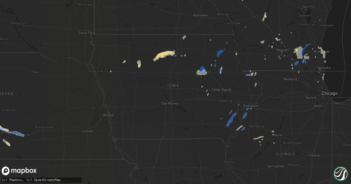
Hail Map in Iowa on July 9, 2020
Get this storm
July 9 map
$229
one time, instant access
Download today. No call, no setup
Keep the $229
Bought the map and want the full workflow? Apply the entire $229 to a subscription within 7 days. None of it is wasted.
Every map, not just this one
This buys you this map. Subscription and you get every map we run, in the markets you choose from a few cities to whole states to nationwide. Plus real-time alerts the moment a storm fires.
Contact data
Name, contact info, occupancy, even credit band for addresses in the footprint. You go from where it hit to who to call.
Become the source they trust
Unlimited branding weather history reports on demand. You already have the documented answer ready for the property owner, and you are the one who showed up with it.
Property data and RoofTrace estimates
Pull up any address you have got, its value and the exact code rules for that jurisdiction, straight from One Click Code. Then RoofTrace estimates the squares, pitch, and roof value, priced the way you price.
Storm reports in Iowa
Iowa
| Date | Description |
|---|---|
| 07/09/20206:35 PM CDT | Corrects previous tstm wnd dmg report from 2 wsw riverdale. Social media post of a large tree snapped near the corner of mississippi blvd and 16th street in bettendorf. |
| 07/09/20206:30 PM CDT | 3 inch diameter branch down. Time estimated from radar. |
| 07/09/20205:40 PM CDT | Law enforcement reported several trees branches down from storms in the town of wilton from storms thursday evening. Time estimated from radar. |
| 07/09/20205:35 PM CDT | Social media post of a large tree snapped near the corner of mississippi blvd and 16th street in bettendorf. Time estimated from radar. |
| 07/09/20205:28 PM CDT | Neighbors 60 foot ash tree split by thunderstorm winds. Max observed wind gust used for timing. Delayed report. |
| 07/09/20205:26 PM CDT | Damage to a peach tree with around 4-6 inch diameter branches broken. Report/picture from social media. Time estimated from radar. |
| 07/09/20204:40 PM CDT | Reported at dubuque regional airport asos. |
| 07/09/20204:25 PM CDT | Corrects previous tstm wnd dmg report from anamosa. Report of a tree and other large branches down in anamosa from social media. Time estimated from radar. Time was cha |
| 07/09/20204:15 PM CDT | Report of a tree down in anamosa from social media. Time estimated from radar. |
| 07/09/20203:50 PM CDT | Social media submitted photo of a tree snapped by the wind. At least 6 inches in diameter trunk. Estimated time to be 330-345pm... But the radar estimate is at 350pm. |
| 07/09/20203:49 PM CDT | Video sent from social media of a tree falling in a yard and onto the road. |
| 07/09/20203:21 PM CDT | Widespread cornfields flattened due to the winds . |
| 07/09/20203:20 PM CDT | Recorded by rwis. |
| 07/09/20202:45 PM CDT | Em reports a large swatch of tall corn was blown over near winthrop... Likely due to microburst winds. Time estimated from radar. |
| 07/09/20202:43 PM CDT | Em reports tree and crop damage in quasqueton... Likely due to microburst winds. Time estimated from radar. |
| 07/09/20202:22 PM CDT | Tree and powerline damage in the waukon area. Time estimated. |
| 07/09/20202:20 PM CDT | Large tree limb broken off tree... About 6 inches or larger. |
| 07/09/20202:10 PM CDT | Tree and powerline damage in postville. |
| 07/09/20201:44 PM CDT | One tree branch down on garage. |
| 07/09/20201:40 PM CDT | Several 8-10 inch tree branches snapped off trees. |
| 07/09/20201:38 PM CDT | Roof blown off of building. Branches down. Time estimated based on radar. |
| 07/09/20201:35 PM CDT | 5 trees down on west charles st. A few other trees down in town. |
| 07/09/20201:29 PM CDT | Large branches down. Estimating 50 to 60 mph winds. |
| 07/09/20201:20 PM CDT | One tree branch down. Time estimated from radar. |
| 07/09/20201:13 PM CDT | A local report indicates 69 MPH wind near WATERLOO REGIONAL AIRPO |
| 07/09/202012:50 PM CDT | A local report indicates 70 MPH wind near WATERLOO REGIONAL AIRPO |
| 07/09/202012:40 PM CDT | Large trees uprooted and tree limbs down. Mailbox damaged. Report via social media. |
| 07/09/202012:40 PM CDT | Large tree smashed pickup truck. Photo via social media. Time estimated. |
| 07/09/202012:35 PM CDT | Crops flattened... Many trees uprooted of various sizes... Playground set demolished... And power out. Report via social media. |
| 07/09/202012:33 PM CDT | Large tree uprooted and many tree limbs down throughout town of cedar falls. Report via kwwl. Report via social media. Time estimated by radar. |
| 07/09/202012:15 PM CDT | Several trees blown down. |
| 07/09/202011:45 AM CDT | Wind gust at the mason city airport. |
| 07/09/202010:27 AM CDT | Trees down in algona. |
| 07/09/20207:59 AM CDT | At 1259 PM CDT, a severe thunderstorm was located near Menominee, or 7 miles west of Galena, moving north at 25 mph. HAZARD...60 mph wind gusts and quarter size hail. SOURCE...Radar indicated. IMPACT...Hail damage to vehicles is expected. Expect wind damage to roofs, siding, and trees. Locations impacted include... Dubuque, Galena, East Dubuque, Menominee, Sageville, Lock And Dam 11, Edmore, Massey, Mud Lake Park, Rockdale, Mines of Spain and Key West. |
| 07/09/20207:58 AM CDT | At 1258 PM CDT, a severe thunderstorm was located over Evansdale, or near Waterloo, moving northeast at 35 mph. HAZARD...60 mph wind gusts. SOURCE...Radar indicated. IMPACT...Expect damage to roofs, siding, and trees. Locations impacted include... Waterloo, Evansdale, Sumner, Elk Run Heights, Crossroads Mall, Washburn, Dunkerton, Readlyn, Raymond and Gilbertville.This includes Interstate 380 between mile markers 63 and 73. |
| 07/09/20207:30 AM CDT | At 1230 PM CDT, a severe thunderstorm was located over Uni-Dome And McLeod Center, or near Cedar Falls, moving north at 20 mph. HAZARD...60 mph wind gusts. SOURCE...Radar indicated. IMPACT...Expect damage to roofs, siding, and trees. Locations impacted include... Waterloo, Cedar Falls, Waverly, Hudson, Denver, Clarksville, Tripoli, Shell Rock, Dike, Waterloo Municipal Airport, Uni-Dome And McLeod Center, Janesville, New Hartford, Plainfield, Frederika, George Wyth State Park and Waverly Municipal Airport. |
| 07/09/20206:11 AM CDT | At 1111 AM CDT, severe thunderstorms were located along a line extending from 8 miles northeast of Belmond to near Sheffield to 7 miles east of Hampton, moving north at 25 mph. HAZARD...60 mph wind gusts. SOURCE...Radar indicated. IMPACT...Expect damage to roofs, siding, and trees. Locations impacted include... Mason City, Nora Springs, Manly, Sheffield, Rockwell, Mason City Municipal Airport, Clear Lake, Thornton, Plymouth, Kensett, Meservey, Grafton, Swaledale, Rock Falls, Hansell, Chapin, Dougherty, Burchinal, Portland and Clear Lake State Park.This includes Interstate 35 between mile markers 172 and 198. |
| 07/09/20205:57 AM CDT | At 1057 AM CDT, a severe thunderstorm was located 7 miles north of Belmond, or 9 miles south of Garner, moving northeast at 20 mph. HAZARD...60 mph wind gusts. SOURCE...Radar indicated. IMPACT...Expect damage to roofs, siding, and trees. Locations impacted include... Klemme and Goodell. |
| 07/09/20205:26 AM CDT | At 1026 AM CDT, a severe thunderstorm was located 13 miles south of Britt, or 14 miles northwest of Clarion, moving north at 15 mph. HAZARD...60 mph wind gusts and quarter size hail. SOURCE...Radar indicated. IMPACT...Hail damage to vehicles is expected. Expect wind damage to roofs, siding, and trees. Locations impacted include... Britt, Eagle Lake, Kanawha, Corwith, Duncan, Hayfield, Hutchins and Eagle Lake State Park. |
| 07/09/20204:54 AM CDT | At 954 AM CDT, a severe thunderstorm was located 13 miles northeast of Dakota City, moving north at 25 mph. HAZARD...60 mph wind gusts and quarter size hail. SOURCE...Radar indicated. IMPACT...Hail damage to vehicles is expected. Expect wind damage to roofs, siding, and trees. Locations impacted include... Algona, Wesley, Livermore, Corwith, Lu Verne, Renwick, St. Joseph, Hardy, St. Benedict, Irvington, Sexton and Aa Call State Park. |
| 07/09/20203:23 AM CDT | At 823 AM CDT, a severe thunderstorm was located near Pocahontas, moving north at 20 mph. HAZARD...60 mph wind gusts and quarter size hail. SOURCE...Radar indicated. IMPACT...Hail damage to vehicles is expected. Expect wind damage to roofs, siding, and trees. Locations impacted include... Pocahontas, Laurens, Fonda, Havelock, Plover, Varina and Pocahontas Municipal Airport. |
| 07/09/20201:09 AM CDT | At 609 PM CDT, severe thunderstorms were located along a line extending from Grand Mound to near Hamlet, moving east at 20 mph. HAZARD...60 mph wind gusts. SOURCE...Radar indicated. IMPACT...Expect damage to roofs, siding, and trees. Locations impacted include... Davenport, Moline, Rock Island, Bettendorf, Clinton, East Moline, Silvis, Eldridge, DeWitt, Colona, Milan, Camanche, Le Claire, Coal Valley, Hampton, Orion, Port Byron, Walcott, Blue Grass and Buffalo.This includes the following highways... Interstate 74 in Iowa between mile markers 1 and 5. Interstate 80 in Iowa between mile markers 283 and 306. Interstate 80 in Illinois between mile markers 1 and 10. Interstate 74 in Illinois between mile markers 1 and 17. Interstate 88 between mile markers 1 and 3. Interstate 280 between mile markers 1 and 18. |
| 07/09/20201:06 AM CDT | At 606 PM CDT, severe thunderstorms were located along a line extending from Keithsburg to Gladstone, moving northeast at 20 mph. HAZARD...60 mph wind gusts. SOURCE...Radar indicated. IMPACT...Expect damage to roofs, siding, and trees. Locations impacted include... Monmouth, Aledo, Oquawka, Burgess, Viola, Kirkwood, Keithsburg, Little York, Biggsville, Gladstone, Rozetta, Seaton, Shale City, Ogle, Alexis, Bald Bluff, Gerlaw, Monmouth Municipal Airport, Sunbeam and Eleanor. |
| 07/08/202011:24 PM CDT | At 424 PM CDT, a severe thunderstorm was located over Morley, or near Mechanicsville, moving northeast at 20 mph. HAZARD...60 mph wind gusts and quarter size hail. SOURCE...Radar indicated. IMPACT...Hail damage to vehicles is expected. Expect wind damage to roofs, siding, and trees. Locations impacted include... Anamosa, Olin, Wyoming, Martelle, Onslow, Morley, Center Junction, Pictured Rocks Wildlife Area, Wapsipinicon State Park, Hale, Camp Courageous, Scotch Grove and Central Park. |
| 07/08/202010:56 PM CDT | At 355 PM CDT, a severe thunderstorm was located near Bertram, or 9 miles southeast of Cedar Rapids, moving northeast at 30 mph. HAZARD...60 mph wind gusts and quarter size hail. SOURCE...Radar indicated. IMPACT...Hail damage to vehicles is expected. Expect wind damage to roofs, siding, and trees. Locations impacted include... Cedar Rapids, Anamosa, Mechanicsville, Marion, Mount Vernon, Lisbon, Solon, Ely, Springville, Olin, Bertram, Martelle, Morley, Lake Macbride State Park, Stone City, Viola, Langworthy, Whittier, Sutliff and Squaw Creek Park.This includes Interstate 380 between mile markers 18 and 23. |
| 07/08/202010:29 PM CDT | At 329 PM CDT, a severe thunderstorm was located over Prairieburg, or 9 miles northwest of Anamosa, moving northeast at 30 mph. HAZARD...60 mph wind gusts and quarter size hail. SOURCE...Radar indicated. IMPACT...Hail damage to vehicles is expected. Expect wind damage to roofs, siding, and trees. Locations impacted include... Monticello, Cascade, Central City, Hopkinton, Worthington, Prairieburg, Waubeek, Langworthy, Stone City, Matsell Bridge Natural Area, Jones County Fairgrounds, Pictured Rocks Wildlife Area, Howard H Cherry Scout Reservation, Buck Creek, Camp Courageous, Temple Hill and Monticello Municipal Airport. |
| 07/08/20209:56 PM CDT | At 256 PM CDT, severe thunderstorms were located along a line extending from near Lamont to near Masonville to near Troy Mills, moving east at 40 mph. HAZARD...60 mph wind gusts. SOURCE...Radar indicated. IMPACT...Expect damage to roofs, siding, and trees. Locations impacted include... Manchester, Earlville, Hopkinton, Delhi, Ryan, Greeley, Dundee, Delaware, Masonville, Oneida, Robinson, Delaware County Fairgrounds, Manchester Airport, Coffins Grove Park, Twin Bridges Park, Buck Creek, Baileys Ford Park, Petersburg and Turtle Creek Park. |
| 07/08/20209:30 PM CDT | At 229 PM CDT, a severe thunderstorm was located over Independence, moving east at 40 mph. HAZARD...60 mph wind gusts. SOURCE...Radar indicated. IMPACT...Expect damage to roofs, siding, and trees. Locations impacted include... Independence, Jesup, Winthrop, Quasqueton, Brandon, Rowley, Lime Creek County Park, Winthrop Golf Course, Wapsipinicon Golf Course, Littleton, Monti, Buchanan County Fairgrounds, Otterville and Independence Airport.This includes Interstate 380 between mile markers 49 and 55. |
| 07/08/20209:19 PM CDT | At 218 PM CDT, a severe thunderstorm was located near Van Horne, or 11 miles north of Marengo, moving northeast at 25 mph. HAZARD...60 mph wind gusts and quarter size hail. SOURCE...Radar indicated. IMPACT...Hail damage to vehicles is expected. Expect wind damage to roofs, siding, and trees. Locations impacted include... Vinton, Newhall, Blairstown, Van Horne, Keystone, Garrison, Vinton Memorial Airport, Benton County Fairgrounds, Rodgers Park, Wildcat Bluff Park, Benton City Park and Hoefle-Dulin Park. |
| 07/08/20208:44 PM CDT | At 143 PM CDT, severe thunderstorms were located along a line extending from 8 miles south of Canton to near Fort Atkinson, moving east at 15 mph. HAZARD...60 mph wind gusts and penny size hail. SOURCE...Radar indicated. IMPACT...Expect damage to roofs, siding, and trees. Severe thunderstorms will be near... Calmar around 150 PM CDT. Decorah around 205 PM CDT. Ossian around 210 PM CDT.Other locations impacted by these severe thunderstorms includeFestina, Nordness, Highlandville, Lake Meyer County Park, GlenwoodChurch, Bluffton and Chimney Rock Campground. |
| 07/08/20208:22 PM CDT | At 121 PM CDT, a severe thunderstorm was located near Waterloo Municipal Airport, or near Cedar Falls, moving northeast at 25 mph. HAZARD...60 mph wind gusts and penny size hail. SOURCE...Radar indicated. IMPACT...Expect damage to roofs, siding, and trees. Locations impacted include... Waterloo, Cedar Falls, Waverly, Denver, Tripoli, Waterloo Municipal Airport, Uni-Dome And McLeod Center, Janesville, Plainfield, Frederika, George Wyth State Park and Waverly Municipal Airport. |
| 07/08/20208:18 PM CDT | At 116 PM CDT, severe thunderstorms were located along a line extending from near Ionia to near Sumner to near Lamont, moving north at 25 mph. HAZARD...60 mph wind gusts and nickel size hail. SOURCE...Radar indicated. IMPACT...Expect damage to roofs, siding, and trees. Severe thunderstorms will be near... Ionia around 125 PM CDT. New Hampton around 135 PM CDT. Hawkeye and Arlington around 145 PM CDT. Jerico around 155 PM CDT. Waucoma around 200 PM CDT. Protivin around 205 PM CDT.Other locations impacted by these severe thunderstorms includeDonnan, Eldorado, Randalia, Highways 3 And 187, New Hampton Airport,Republic and Highway 18 And County V 18. |
| 07/08/20208:11 PM CDT | At 111 PM CDT, a severe thunderstorm was located over Winthrop, or 8 miles east of Independence, moving northwest at 20 mph. HAZARD...60 mph wind gusts and quarter size hail. SOURCE...Radar indicated. IMPACT...Hail damage to vehicles is expected. Expect wind damage to roofs, siding, and trees. Locations impacted include... Independence, Winthrop, Hazleton, Quasqueton, Lamont, Aurora, Stanley, Buchanan County Fairgrounds, Winthrop Golf Course, Jakway Park, Fontana County Park and Fontana Park. |
All States Impacted by Hail Map on July 9, 2020
Cities Impacted by Hail Map on July 9, 2020
- Iliff, CO
- Peetz, CO
- Cedar Falls, IA
- Dike, IA
- Hudson, IA
- Ashby, NE
- Hyannis, NE
- Merriman, NE
- Bingham, NE
- Vale, SD
- Sturgis, SD
- Whitewood, SD
- Bayard, NE
- Dalton, NE
- Broadwater, NE
- Bridgeport, NE
- Dickens, TX
- Paducah, TX
- Newell, SD
- Knoxville, TN
- Mapleton, ME
- Morrow, OH
- South Lebanon, OH
- Memphis, TX
- Rozet, WY
- Bennett, CO
- Strasburg, CO
- Cozad, NE
- Brady, NE
- Gothenburg, NE
- Spragueville, IA
- Bellevue, IA
- Preston, IA
- Ellsworth, NE
- Watkins, CO
- Bluff City, KS
- Caldwell, KS
- Medford, OK
- Freeport, KS
- Stoneham, CO
- Potter, NE
- Custer, SD
- Fountain, MI
- Branch, MI
- Wheatland, WY
- Bertrand, NE
- Owatonna, MN
- Bagley, WI
- Byers, CO
- Allen, SD
- Johnson Creek, WI
- Jefferson, WI
- Lake Mills, WI
- Crawford, NE
- Lakeside, NE
- Gillette, WY
- Whitney, NE
- Hermosa, SD
- Keystone, SD
- Commerce City, CO
- Brighton, CO
- Henderson, CO
- Lewiston, MI
- Beulah, WY
- Grenola, KS
- Latham, KS
- Norwalk, OH
- Belle Fourche, SD
- Aladdin, WY
- Spearfish, SD
- Sundance, WY
- Moorcroft, WY
- Kensett, IA
- Saint Ansgar, IA
- Northwood, IA
- Grafton, IA
- New Raymer, CO
- Merino, CO
- Ashland, ME
- Neenah, WI
- Deer Trail, CO
- Pine Ridge, SD
- Harrison, NE
- Marsland, NE
- Saint Cloud, WI
- Bellevue, OH
- Orchard, CO
- Kersey, CO
- Roggen, CO
- Sycamore, PA
- Graysville, PA
- North Platte, NE
- Byron Center, MI
- Lyons, KS
- Little River, KS
- Upton, WY
- Waldron, KS
- Laurens, IA
- Pocahontas, IA
- Rockford, MI
- Ada, MI
- Belmont, MI
- Morley, MI
- Sand Lake, MI
- Pierson, MI
- Howard City, MI
- Luzerne, MI
- Dexter, MI
- Edgemont, SD
- Chadron, NE
- Oelrichs, SD
- Hemingford, NE
- Alliance, NE
- Guernsey, WY
- Midland, SD
- Wichita, KS
- Sheffield, IA
- East Troy, WI
- Childress, TX
- Matador, TX
- Cambridge Springs, PA
- Union City, PA
- Grover, CO
- Tryon, NE
- Hershey, NE
- Lu Verne, IA
- Livermore, IA
- Corwith, IA
- Hardy, IA
- Renwick, IA
- Waynesfield, OH
- Wapakoneta, OH
- Murdock, KS
- Cheney, KS
- Merrillan, WI
- Alma Center, WI
- Canton, IL
- Arthur, NE
- Sutherland, NE
- Oregon, WI
- Ellis, KS
- Kanawha, IA
- Whitman, NE
- Limon, CO
- Padroni, CO
- Denver, CO
- Aurora, CO
- Bay Port, MI
- Sebewaing, MI
- Agate, CO
- Elkhorn, WI
- Grand Rapids, OH
- Rapid City, SD
- Claflin, KS
- Holyrood, KS
- Cee Vee, TX
- Tell, TX
- Mazeppa, MN
- Garden, MI
- Garner, IA
- Britt, IA
- Goodell, IA
- Klemme, IA
- Hay Springs, NE
- Mio, MI
- Burrton, KS
- Fairburn, SD
- Sedgwick, CO
- Ovid, CO
- Fonda, IA
- Irons, MI
- Custer, MI
- Patten, ME
- Sandusky, OH
- Monroeville, OH
- Watson, AR
- Alta, IA
- Black Earth, WI
- Mazomanie, WI
- New Underwood, SD
- Union Center, SD
- Port Clinton, OH
- Merrimac, WI
- Wall, SD
- Wasta, SD
- Howes, SD
- Enning, SD
- Brighton, MI
- Milford, MI
- South Lyon, MI
- Rockford, TN
- Muskego, WI
- Brooksville, MS
- Torrington, WY
- Winthrop, IA
- Coopersville, MI
- Marne, MI
- Merigold, MS
- Cleveland, MS
- Butler, KY
- California, KY
- Oshkosh, NE
- Bushton, KS
- Brooklyn, WI
- Belleville, WI
- Conway Springs, KS
- North Fairfield, OH
- Willard, OH
- Venedocia, OH
- Williamstown, KY
- Dry Ridge, KY
- Havelock, IA
- Rock Island, IL
- Milan, IL
- Summers, AR
- Westville, OK
- Mineral Point, WI
- Julesburg, CO
- Lexington, NE
- Otis, KS
- Bison, KS
- La Crosse, KS
- Albert, KS
- Larned, KS
- Rush Center, KS
- Pawnee Rock, KS
- Maineville, OH
- Kings Mills, OH
- Lebanon, OH
- Cresco, IA
- New Lisbon, WI
- Necedah, WI
- Waterloo, IA
- Argonia, KS
- Danville, KS
- Maryville, TN
- Keenesburg, CO
- Bokoshe, OK
- Shady Point, OK
- Poteau, OK
- Cameron, OK
- Dix, NE
- Spiro, OK
- Galena, IL
- Nevada, OH
- Marion, OH
- Dousman, WI
- Carpenter, WY
- Lenoir City, TN
- La Salle, CO
- Hudson, CO
- Fort Lupton, CO
- Haven, KS
- Wayland, IA
- Lake Cormorant, MS
- Burlington, IA
- Oquawka, IL
- Gladstone, IL
- Morral, OH
- Belle Plaine, IA
- Luzerne, IA
- Marengo, IA
- Ladora, IA
- Victor, IA
- Ogallah, KS
- Hayes, SD
- Lake Villa, IL
- Sandy Lake, PA
- Grand Rapids, MI
- Blairsville, GA
- Harper, KS
- Scenic, SD
- Kenosha, WI
- Okaton, SD
- Lake Zurich, IL
- Elm Creek, NE
- Martin, SD
- Imlay City, MI
- Capac, MI
- Hartville, WY
- Humboldt, IA
- Rutland, IA
- Clear Lake, IA
- Goldfield, IA
- Thornton, IA
- Meservey, IA
- Hays, KS
- Nash, OK
- Wakita, OK
- Chelsea, MI
- Cambridge, WI
- Saint Francis, WI
- South Milwaukee, WI
- Cudahy, WI
- Milwaukee, WI
- Oak Creek, WI
- Keystone, IA
- Dougherty, IA
- Claremont, MN
- Oxford, KS
- Aurelia, IA
- Lima, OH
- Buckland, OH
- Delphos, OH
- Roscommon, MI
- Elwood, NE
- Fairmont, WV
- Shinnston, WV
- Bridgeport, WV
- Liberty, IN
- Luther, MI
- Maxwell, NE
- Leon, KS
- Pekin, IL
- Green Valley, IL
- Wellington, TX
- Hutchinson, KS
- Pretty Prairie, KS
- Lincoln, AR
- Canehill, AR
- Cuba, IL
- Sussex, WI
- Pewaukee, WI
- Bunker Hill, KS
- Dorrance, KS
- Wilson, KS
- Corry, PA
- Spartansburg, PA
- Shelby, MS
- Duncan, MS
- Fairbank, IA
- Frankfort, KY
- Indianola, PA
- Cheswick, PA
- Allison Park, PA
- Pittsburgh, PA
- Wanblee, SD
- Long Valley, SD
- Atlanta, MI
- West Mansfield, OH
- Raymond, OH
- Fort Atkinson, WI
- Geneseo, KS
- Boyle, MS
- Buhler, KS
- Mound Bayou, MS
- Lodi, WI
- Mullen, NE
- Stockbridge, MI
- Castalia, OH
- Clyde, OH
- Randolph, WI
- Cambria, WI
- Wellington, KS
- Waukegan, IL
- Zion, IL
- Whitmore Lake, MI
- Ellinwood, KS
- Mills River, NC
- Horse Shoe, NC
- Masonville, IA
- Lamont, IA
- Portage, WI
- Lance Creek, WY
- Ellijay, GA
- Unionville, MI
- Hanna City, IL
- Correctionville, IA
- Marshfield, WI
- Cashton, WI
- Westby, WI
- Van Wert, OH
- Ohio City, OH
- Bucyrus, OH
- London Mills, IL
- Farmington, IL
- Avon, IL
- Fairview, IL
- Bushnell, IL
- Ellisville, IL
- Prairie City, IL
- Racine, WI
- Cottonwood, ID
- Whitewater, WI
- Elkhart Lake, WI
- Kiel, WI
- Evansdale, IA
- Grandville, MI
- Wyoming, MI
- Presque Isle, ME
- Lewistown, IL
- Edgerton, WI
- Milton, WI
- Kingman, KS
- Norwich, KS
- Raymond, IA
- Palms, MI
- Deckerville, MI
- Toxey, AL
- Lewisburg, OH
- Mount Hope, KS
- Gunnison, MS
- Poplar Grove, IL
- Sharon, WI
- Capron, IL
- Crab Orchard, TN
- Rockwood, TN
- Salina, OK
- Spavinaw, OK
- Lake Forest, IL
- Great Lakes, IL
- Lake Bluff, IL
- North Chicago, IL
- Clutier, IA
- Rushville, NE
- Winfield, KS
- Plain, WI
- Lone Rock, WI
- Loganville, WI
- Hillpoint, WI
- Spring Green, WI
- Anthony, KS
- Maynard, IA
- Darlington, WI
- Hoisington, KS
- Palmyra, WI
- Mukwonago, WI
- Eagle, WI
- Oconomowoc, WI
- Stoneboro, PA
- Gibsonburg, OH
- Lindsey, OH
- Janesville, WI
- Beloit, WI
- Reinbeck, IA
- La Porte City, IA
- Sullivan, WI
- Watertown, WI
- Helenville, WI
- Hazel Green, WI
- East Dubuque, IL
- Deadwood, SD
- Arena, WI
- Ironton, OH
- Princeville, IL
- Dunlap, IL
- Edwards, IL
- Brimfield, IL
- Twinsburg, OH
- Stapleton, NE
- Plymouth, OH
- Solon, OH
- McCracken, KS
- Schoenchen, KS
- Rubicon, WI
- Ordway, CO
- Jasper, GA
- Fort Pierre, SD
- Milesville, SD
- Middle Point, OH
- Biggsville, IL
- Joy, IL
- Reynolds, IL
- Aledo, IL
- Andalusia, IL
- Taylor Ridge, IL
- Crook, CO
- Thornton, CO
- Venango, NE
- Sauk City, WI
- Prairie Du Sac, WI
- Dane, WI
- Deforest, WI
- Arlington, WI
- Madison, WI
- Stoughton, WI
- Avalon, WI
- Hartford, WI
- Ixonia, WI
- Janesville, IA
- Oelwein, IA
- Hazleton, IA
- Elgin, IA
- Fayette, IA
- West Union, IA
- Ossian, IA
- Castalia, IA
- Clermont, IA
- Waukon, IA
- Postville, IA
- La Motte, IA
- Zwingle, IA
- Dubuque, IA
- Grandview, IA
- Letts, IA
- Yarmouth, IA
- Mount Union, IA
- Mount Pleasant, IA
- Muscatine, IA
- Wapello, IA
- Morning Sun, IA
- New London, IA
- Columbus Junction, IA
- Winfield, IA
- Conesville, IA
- Moscow, IA
- Wilton, IA
- Bentonville, AR
- Siloam Springs, AR
- Rogers, AR
- Cave Springs, AR
- Farmington, AR
- Lowell, AR
- Gentry, AR
- Fayetteville, AR
- Springdale, AR
- Uniontown, AR
- Evansville, AR
- Natural Dam, AR
- Rudy, AR
- Van Buren, AR
- Cedarville, AR
- Stilwell, OK
- Odessa, NE
- Willow Island, NE
- Overton, NE
- Kearney, NE


