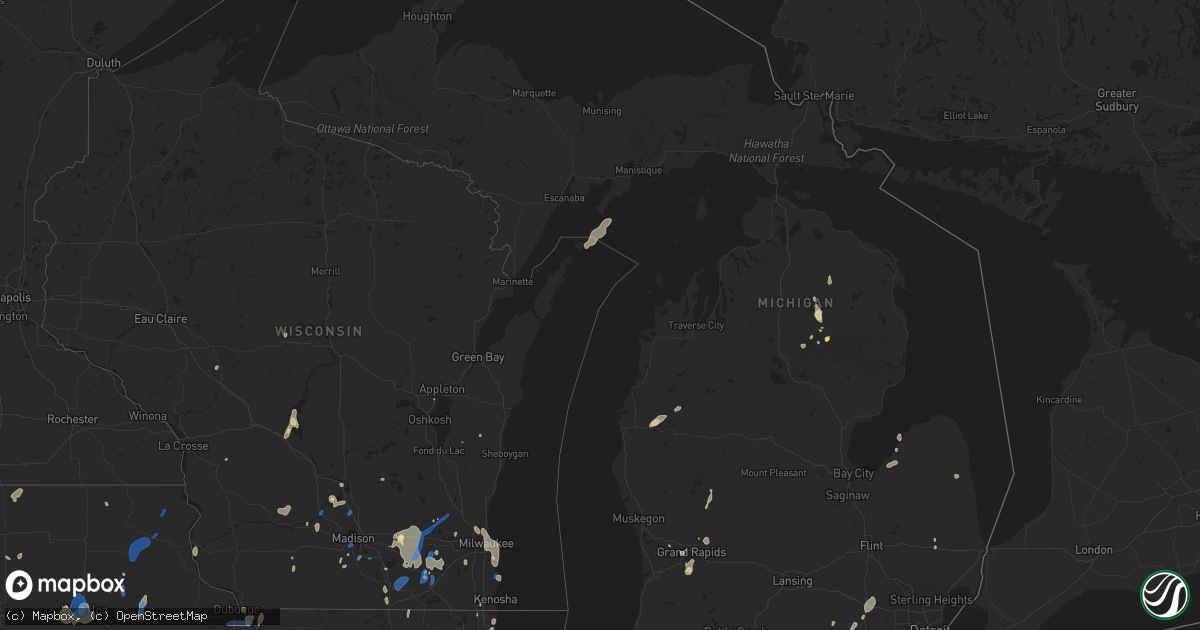
Hail Map in Michigan on July 9, 2020
Get this storm
July 9 map
$229
one time, instant access
Download today. No call, no setup
Keep the $229
Bought the map and want the full workflow? Apply the entire $229 to a subscription within 7 days. None of it is wasted.
Every map, not just this one
This buys you this map. Subscription and you get every map we run, in the markets you choose from a few cities to whole states to nationwide. Plus real-time alerts the moment a storm fires.
Contact data
Name, contact info, occupancy, even credit band for addresses in the footprint. You go from where it hit to who to call.
Become the source they trust
Unlimited branding weather history reports on demand. You already have the documented answer ready for the property owner, and you are the one who showed up with it.
Property data and RoofTrace estimates
Pull up any address you have got, its value and the exact code rules for that jurisdiction, straight from One Click Code. Then RoofTrace estimates the squares, pitch, and roof value, priced the way you price.
Storm reports in Michigan
Michigan
| Date | Description |
|---|---|
| 07/09/20205:51 PM CDT | A local report indicates 1.00 inch wind near LEWISTON |
| 07/09/20205:49 PM CDT | Tree down on cabin from winds off of lake. Time estimated from radar. |
| 07/09/20205:30 PM CDT | Downed powerline in buel township near peck and kilgore roads. Time estimated based on radar. |
| 07/09/20205:30 PM CDT | Numerous trees down from thunderstorm winds. Power and cable companies... As well as road commission clearing trees. Time of storm based on radar and 911 calls to montm |
| 07/09/20205:24 PM CDT | Powerlines down. |
| 07/09/20205:17 PM CDT | Trees blocking road on cr 628... E of m-33 about 4-6 miles north of atlanta. |
| 07/09/20204:53 PM CDT | Microburst. Several public reports and photos between byron center and cutlerville of snapped or uprooted trees. Occurred with half inch hail. |
| 07/09/20204:50 PM CDT | 2 downed trees: 1 uprooted... The other with the trunk snapped. |
| 07/09/20204:50 PM CDT | Microburst. Spruce tree snapped. Vinyl fence panels blown out. |
| 07/09/20203:12 PM CDT | Tree down at colfax and taylor. |
| 07/09/20204:41 AM CDT | At 940 PM EDT, a severe thunderstorm was located over Dexter, moving northeast at 20 mph. HAZARD...60 mph wind gusts. SOURCE...Radar indicated. IMPACT...Expect damage to roofs, siding, and trees. This severe thunderstorm will be near... Hamburg around 1010 PM EDT. Whitmore Lake around 1015 PM EDT. Brighton around 1030 PM EDT.Other locations impacted by this severe thunderstorm include IslandLake State Recreation Area, Hudson Mills, Chilson, Delhi Mills,Lakeland and Hudson Mills Metropark. |
| 07/09/20201:20 AM CDT | At 618 PM EDT, a severe thunderstorm was located over Marlette, moving northeast at 10 mph. HAZARD...60 mph wind gusts. SOURCE...Radar indicated. IMPACT...Expect damage to roofs, siding, and trees. This severe thunderstorm will be near... Argyle around 715 PM EDT.Additional strong to severe thunderstorms will be possible across the Sanilac county over the next hour. These storms will be capable of producing wind gusts of 50 to 60 mph. Locations potentially impacted include McGregor, Snover, Juhl, Elmer, Valley Center, New Greenleaf, Tyre, Decker, Palms and Watertown. |
| 07/09/20201:07 AM CDT | At 606 PM EDT, a severe thunderstorm was located over Capac, moving northeast at 5 mph. HAZARD...60 mph wind gusts. SOURCE...Radar indicated. IMPACT...Expect damage to roofs, siding, and trees. This severe thunderstorm will be near... Capac around 620 PM EDT. Yale around 700 PM EDT.Additional strong to severe thunderstorms will be possible over the next hour across the warned area. These storms will be capable of producing wind gusts of 50 to 60 mph. Locations that may impacted by this severe thunderstorm include Allenton, Goodland Township, Lakeville, Berville, Lynn Township, Leonard and Brockway. |
| 07/09/202012:54 AM CDT | At 553 PM EDT, a severe thunderstorm was located over Mio, moving northwest at 10 mph. HAZARD...Quarter size hail. SOURCE...Radar indicated. IMPACT...Damage to vehicles is expected. Locations impacted include... Mio, Fairview, Luzerne and Red Oak. |
| 07/08/202010:17 PM CDT | About 15 trees uprooted... Damaged... Or split in half around the sashabaw middle school. |
| 07/08/20209:21 PM CDT | Trees and wires downed near pettysville rd. |
| 07/08/20208:50 PM CDT | *** 1 inj *** several 2-3 feet diameter trees downed. One large hardwood tree fell through a roof and into the living room of a home near todds lane and donovan road. E |
All States Impacted by Hail Map on July 9, 2020
Cities Impacted by Hail Map on July 9, 2020
- Iliff, CO
- Peetz, CO
- Cedar Falls, IA
- Dike, IA
- Hudson, IA
- Ashby, NE
- Hyannis, NE
- Merriman, NE
- Bingham, NE
- Vale, SD
- Sturgis, SD
- Whitewood, SD
- Bayard, NE
- Dalton, NE
- Broadwater, NE
- Bridgeport, NE
- Dickens, TX
- Paducah, TX
- Newell, SD
- Knoxville, TN
- Mapleton, ME
- Morrow, OH
- South Lebanon, OH
- Memphis, TX
- Rozet, WY
- Bennett, CO
- Strasburg, CO
- Cozad, NE
- Brady, NE
- Gothenburg, NE
- Spragueville, IA
- Bellevue, IA
- Preston, IA
- Ellsworth, NE
- Watkins, CO
- Bluff City, KS
- Caldwell, KS
- Medford, OK
- Freeport, KS
- Stoneham, CO
- Potter, NE
- Custer, SD
- Fountain, MI
- Branch, MI
- Wheatland, WY
- Bertrand, NE
- Owatonna, MN
- Bagley, WI
- Byers, CO
- Allen, SD
- Johnson Creek, WI
- Jefferson, WI
- Lake Mills, WI
- Crawford, NE
- Lakeside, NE
- Gillette, WY
- Whitney, NE
- Hermosa, SD
- Keystone, SD
- Commerce City, CO
- Brighton, CO
- Henderson, CO
- Lewiston, MI
- Beulah, WY
- Grenola, KS
- Latham, KS
- Norwalk, OH
- Belle Fourche, SD
- Aladdin, WY
- Spearfish, SD
- Sundance, WY
- Moorcroft, WY
- Kensett, IA
- Saint Ansgar, IA
- Northwood, IA
- Grafton, IA
- New Raymer, CO
- Merino, CO
- Ashland, ME
- Neenah, WI
- Deer Trail, CO
- Pine Ridge, SD
- Harrison, NE
- Marsland, NE
- Saint Cloud, WI
- Bellevue, OH
- Orchard, CO
- Kersey, CO
- Roggen, CO
- Sycamore, PA
- Graysville, PA
- North Platte, NE
- Byron Center, MI
- Lyons, KS
- Little River, KS
- Upton, WY
- Waldron, KS
- Laurens, IA
- Pocahontas, IA
- Rockford, MI
- Ada, MI
- Belmont, MI
- Morley, MI
- Sand Lake, MI
- Pierson, MI
- Howard City, MI
- Luzerne, MI
- Dexter, MI
- Edgemont, SD
- Chadron, NE
- Oelrichs, SD
- Hemingford, NE
- Alliance, NE
- Guernsey, WY
- Midland, SD
- Wichita, KS
- Sheffield, IA
- East Troy, WI
- Childress, TX
- Matador, TX
- Cambridge Springs, PA
- Union City, PA
- Grover, CO
- Tryon, NE
- Hershey, NE
- Lu Verne, IA
- Livermore, IA
- Corwith, IA
- Hardy, IA
- Renwick, IA
- Waynesfield, OH
- Wapakoneta, OH
- Murdock, KS
- Cheney, KS
- Merrillan, WI
- Alma Center, WI
- Canton, IL
- Arthur, NE
- Sutherland, NE
- Oregon, WI
- Ellis, KS
- Kanawha, IA
- Whitman, NE
- Limon, CO
- Padroni, CO
- Denver, CO
- Aurora, CO
- Bay Port, MI
- Sebewaing, MI
- Agate, CO
- Elkhorn, WI
- Grand Rapids, OH
- Rapid City, SD
- Claflin, KS
- Holyrood, KS
- Cee Vee, TX
- Tell, TX
- Mazeppa, MN
- Garden, MI
- Garner, IA
- Britt, IA
- Goodell, IA
- Klemme, IA
- Hay Springs, NE
- Mio, MI
- Burrton, KS
- Fairburn, SD
- Sedgwick, CO
- Ovid, CO
- Fonda, IA
- Irons, MI
- Custer, MI
- Patten, ME
- Sandusky, OH
- Monroeville, OH
- Watson, AR
- Alta, IA
- Black Earth, WI
- Mazomanie, WI
- New Underwood, SD
- Union Center, SD
- Port Clinton, OH
- Merrimac, WI
- Wall, SD
- Wasta, SD
- Howes, SD
- Enning, SD
- Brighton, MI
- Milford, MI
- South Lyon, MI
- Rockford, TN
- Muskego, WI
- Brooksville, MS
- Torrington, WY
- Winthrop, IA
- Coopersville, MI
- Marne, MI
- Merigold, MS
- Cleveland, MS
- Butler, KY
- California, KY
- Oshkosh, NE
- Bushton, KS
- Brooklyn, WI
- Belleville, WI
- Conway Springs, KS
- North Fairfield, OH
- Willard, OH
- Venedocia, OH
- Williamstown, KY
- Dry Ridge, KY
- Havelock, IA
- Rock Island, IL
- Milan, IL
- Summers, AR
- Westville, OK
- Mineral Point, WI
- Julesburg, CO
- Lexington, NE
- Otis, KS
- Bison, KS
- La Crosse, KS
- Albert, KS
- Larned, KS
- Rush Center, KS
- Pawnee Rock, KS
- Maineville, OH
- Kings Mills, OH
- Lebanon, OH
- Cresco, IA
- New Lisbon, WI
- Necedah, WI
- Waterloo, IA
- Argonia, KS
- Danville, KS
- Maryville, TN
- Keenesburg, CO
- Bokoshe, OK
- Shady Point, OK
- Poteau, OK
- Cameron, OK
- Dix, NE
- Spiro, OK
- Galena, IL
- Nevada, OH
- Marion, OH
- Dousman, WI
- Carpenter, WY
- Lenoir City, TN
- La Salle, CO
- Hudson, CO
- Fort Lupton, CO
- Haven, KS
- Wayland, IA
- Lake Cormorant, MS
- Burlington, IA
- Oquawka, IL
- Gladstone, IL
- Morral, OH
- Belle Plaine, IA
- Luzerne, IA
- Marengo, IA
- Ladora, IA
- Victor, IA
- Ogallah, KS
- Hayes, SD
- Lake Villa, IL
- Sandy Lake, PA
- Grand Rapids, MI
- Blairsville, GA
- Harper, KS
- Scenic, SD
- Kenosha, WI
- Okaton, SD
- Lake Zurich, IL
- Elm Creek, NE
- Martin, SD
- Imlay City, MI
- Capac, MI
- Hartville, WY
- Humboldt, IA
- Rutland, IA
- Clear Lake, IA
- Goldfield, IA
- Thornton, IA
- Meservey, IA
- Hays, KS
- Nash, OK
- Wakita, OK
- Chelsea, MI
- Cambridge, WI
- Saint Francis, WI
- South Milwaukee, WI
- Cudahy, WI
- Milwaukee, WI
- Oak Creek, WI
- Keystone, IA
- Dougherty, IA
- Claremont, MN
- Oxford, KS
- Aurelia, IA
- Lima, OH
- Buckland, OH
- Delphos, OH
- Roscommon, MI
- Elwood, NE
- Fairmont, WV
- Shinnston, WV
- Bridgeport, WV
- Liberty, IN
- Luther, MI
- Maxwell, NE
- Leon, KS
- Pekin, IL
- Green Valley, IL
- Wellington, TX
- Hutchinson, KS
- Pretty Prairie, KS
- Lincoln, AR
- Canehill, AR
- Cuba, IL
- Sussex, WI
- Pewaukee, WI
- Bunker Hill, KS
- Dorrance, KS
- Wilson, KS
- Corry, PA
- Spartansburg, PA
- Shelby, MS
- Duncan, MS
- Fairbank, IA
- Frankfort, KY
- Indianola, PA
- Cheswick, PA
- Allison Park, PA
- Pittsburgh, PA
- Wanblee, SD
- Long Valley, SD
- Atlanta, MI
- West Mansfield, OH
- Raymond, OH
- Fort Atkinson, WI
- Geneseo, KS
- Boyle, MS
- Buhler, KS
- Mound Bayou, MS
- Lodi, WI
- Mullen, NE
- Stockbridge, MI
- Castalia, OH
- Clyde, OH
- Randolph, WI
- Cambria, WI
- Wellington, KS
- Waukegan, IL
- Zion, IL
- Whitmore Lake, MI
- Ellinwood, KS
- Mills River, NC
- Horse Shoe, NC
- Masonville, IA
- Lamont, IA
- Portage, WI
- Lance Creek, WY
- Ellijay, GA
- Unionville, MI
- Hanna City, IL
- Correctionville, IA
- Marshfield, WI
- Cashton, WI
- Westby, WI
- Van Wert, OH
- Ohio City, OH
- Bucyrus, OH
- London Mills, IL
- Farmington, IL
- Avon, IL
- Fairview, IL
- Bushnell, IL
- Ellisville, IL
- Prairie City, IL
- Racine, WI
- Cottonwood, ID
- Whitewater, WI
- Elkhart Lake, WI
- Kiel, WI
- Evansdale, IA
- Grandville, MI
- Wyoming, MI
- Presque Isle, ME
- Lewistown, IL
- Edgerton, WI
- Milton, WI
- Kingman, KS
- Norwich, KS
- Raymond, IA
- Palms, MI
- Deckerville, MI
- Toxey, AL
- Lewisburg, OH
- Mount Hope, KS
- Gunnison, MS
- Poplar Grove, IL
- Sharon, WI
- Capron, IL
- Crab Orchard, TN
- Rockwood, TN
- Salina, OK
- Spavinaw, OK
- Lake Forest, IL
- Great Lakes, IL
- Lake Bluff, IL
- North Chicago, IL
- Clutier, IA
- Rushville, NE
- Winfield, KS
- Plain, WI
- Lone Rock, WI
- Loganville, WI
- Hillpoint, WI
- Spring Green, WI
- Anthony, KS
- Maynard, IA
- Darlington, WI
- Hoisington, KS
- Palmyra, WI
- Mukwonago, WI
- Eagle, WI
- Oconomowoc, WI
- Stoneboro, PA
- Gibsonburg, OH
- Lindsey, OH
- Janesville, WI
- Beloit, WI
- Reinbeck, IA
- La Porte City, IA
- Sullivan, WI
- Watertown, WI
- Helenville, WI
- Hazel Green, WI
- East Dubuque, IL
- Deadwood, SD
- Arena, WI
- Ironton, OH
- Princeville, IL
- Dunlap, IL
- Edwards, IL
- Brimfield, IL
- Twinsburg, OH
- Stapleton, NE
- Plymouth, OH
- Solon, OH
- McCracken, KS
- Schoenchen, KS
- Rubicon, WI
- Ordway, CO
- Jasper, GA
- Fort Pierre, SD
- Milesville, SD
- Middle Point, OH
- Biggsville, IL
- Joy, IL
- Reynolds, IL
- Aledo, IL
- Andalusia, IL
- Taylor Ridge, IL
- Crook, CO
- Thornton, CO
- Venango, NE
- Sauk City, WI
- Prairie Du Sac, WI
- Dane, WI
- Deforest, WI
- Arlington, WI
- Madison, WI
- Stoughton, WI
- Avalon, WI
- Hartford, WI
- Ixonia, WI
- Janesville, IA
- Oelwein, IA
- Hazleton, IA
- Elgin, IA
- Fayette, IA
- West Union, IA
- Ossian, IA
- Castalia, IA
- Clermont, IA
- Waukon, IA
- Postville, IA
- La Motte, IA
- Zwingle, IA
- Dubuque, IA
- Grandview, IA
- Letts, IA
- Yarmouth, IA
- Mount Union, IA
- Mount Pleasant, IA
- Muscatine, IA
- Wapello, IA
- Morning Sun, IA
- New London, IA
- Columbus Junction, IA
- Winfield, IA
- Conesville, IA
- Moscow, IA
- Wilton, IA
- Bentonville, AR
- Siloam Springs, AR
- Rogers, AR
- Cave Springs, AR
- Farmington, AR
- Lowell, AR
- Gentry, AR
- Fayetteville, AR
- Springdale, AR
- Uniontown, AR
- Evansville, AR
- Natural Dam, AR
- Rudy, AR
- Van Buren, AR
- Cedarville, AR
- Stilwell, OK
- Odessa, NE
- Willow Island, NE
- Overton, NE
- Kearney, NE


