Hail Map on July 9, 2020
Get this storm
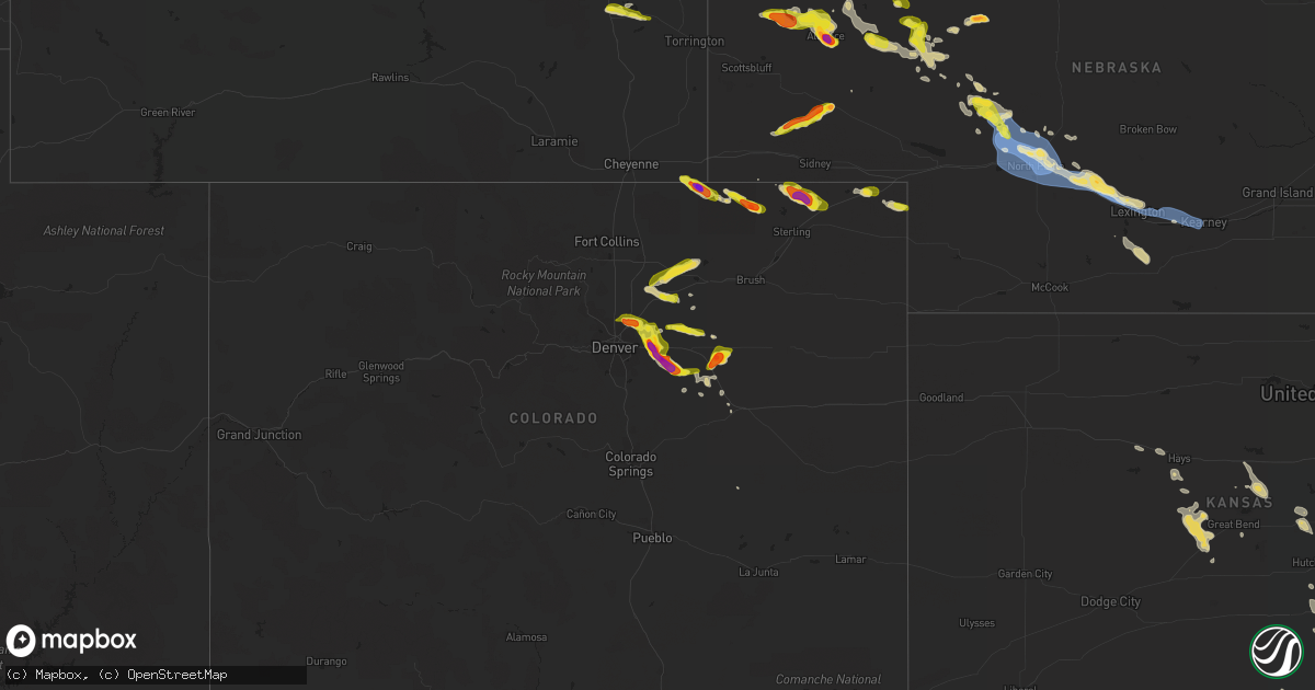
July 9 map
$229
one time, instant access
Download today. No call, no setup
Keep the $229
Bought the map and want the full workflow? Apply the entire $229 to a subscription within 7 days. None of it is wasted.
Every map, not just this one
This buys you this map. Subscription and you get every map we run, in the markets you choose from a few cities to whole states to nationwide. Plus real-time alerts the moment a storm fires.
Contact data
Name, contact info, occupancy, even credit band for addresses in the footprint. You go from where it hit to who to call.
Become the source they trust
Unlimited branding weather history reports on demand. You already have the documented answer ready for the property owner, and you are the one who showed up with it.
Property data and RoofTrace estimates
Pull up any address you have got, its value and the exact code rules for that jurisdiction, straight from One Click Code. Then RoofTrace estimates the squares, pitch, and roof value, priced the way you price.
States Impacted by Hail Map on July 9, 2020
Storm reports
Illinois
| Date | Description |
|---|---|
| 07/09/20206:48 PM CDT | A large tree limb was blown down. Photo shared on facebook. Time estimated. |
| 07/09/20206:41 PM CDT | Large tree limb blown down. Photo shared on facebook. Time estimated. |
| 07/09/20206:23 PM CDT | Highway sign blown over and damage to a corn field... Likely due to microburst. Picture from social media. Time estimated from radar. |
| 07/09/20206:21 PM CDT | Large tree branch down due to strong winds in andalusia... Report/picture from social media. Time estimated from radar. |
| 07/09/20206:19 PM CDT | Photo from social media showing a downed power pole in aledo; lp tank next to it was also blown over with damage to corn nearby. Time estimated from radar. |
| 07/09/20205:59 PM CDT | Social media picture of a large tree snapped in joy due to thunderstorm winds. Time estimated from radar. |
| 07/09/20205:58 PM CDT | Corrects previous tstm wnd dmg report from 1 se joy. Received a photo from social media of a field of corn blown over... Likely due to microburst from storms. Time esti |
| 07/09/20204:58 PM CDT | Received a photo from social media of a field of corn blown over... Likely due to microburst from storms. Time estimated from radar. |
| 07/09/20204:40 PM CDT | A few trees down on highway 20 near menominee. Time estimated from radar. |
| 07/09/20204:16 AM CDT | At 915 PM CDT, a severe thunderstorm was located near Easton, or 7 miles east of Havana, moving east at 45 mph. HAZARD...60 mph wind gusts. SOURCE...Radar indicated. IMPACT...Expect damage to roofs, siding, and trees. Locations impacted include... Mason City, Delavan, Manito, Hopedale, Green Valley, San Jose, Emden, Easton and Forest City.This includes Interstate 155 between mile markers 10 and 18. |
| 07/09/20203:41 AM CDT | At 841 PM CDT, severe thunderstorms were located along a line extending from Princeville to St. David to near Ipava, moving east at 30 mph. HAZARD...60 mph wind gusts. SOURCE...Radar indicated. IMPACT...Expect damage to roofs, siding, and trees. Locations impacted include... Peoria, Canton, Havana, Lewistown, Bartonville, Chillicothe, West Peoria, Bellevue, Princeville, Rome, Manito, Dunlap, Hanna City, Glasford, Trivoli, St. David, Spring Bay, Kickapoo, Peoria Heights and Norwood.This includes the following highways... Interstate 474 between mile markers 0 and 7. Interstate 74 between mile markers 76 and 92. |
| 07/09/20202:38 AM CDT | At 738 PM CDT, severe thunderstorms were located along a line extending from Altona to near Prairie City, moving northeast at 40 mph. HAZARD...60 mph wind gusts. SOURCE...Radar indicated. IMPACT...Expect damage to roofs, siding, and trees. Locations impacted include... Canton, Abingdon, Knoxville, Farmington, Elmwood, Princeville, Wyoming, Cuba, Toulon, Hanna City, Glasford, Trivoli, Osceola, Brimfield, Avon, Oneida, Yates City, St. David, Williamsfield and Altona.This includes Interstate 74 between mile markers 50 and 80. |
| 07/09/20202:24 AM CDT | At 723 PM CDT, a severe thunderstorm was located over Little Swan Lake, or 13 miles northeast of Macomb, moving east at 25 mph. HAZARD...60 mph wind gusts and quarter size hail. SOURCE...Radar indicated. IMPACT...Hail damage to vehicles is expected. Expect wind damage to roofs, siding, and trees. Locations impacted include... Macomb, Bushnell, Roseville, Avon, Blandinsville, Good Hope, Prairie City, Sciota, Little Swan Lake, Walnut Grove, Greenbush, Macomb Municipal Airport, Scottsburg, Swan Creek, Youngstown, Prairie City Airport and Spring Lake. |
| 07/09/20202:14 AM CDT | At 713 PM CDT, a severe thunderstorm was located near Monmouth, moving northeast at 35 mph. HAZARD...60 mph wind gusts and quarter size hail. SOURCE...Radar indicated. IMPACT...Hail damage to vehicles is expected. Expect wind damage to roofs, siding, and trees. Locations impacted include... Monmouth, Coldbrook, Berwick, Monmouth Municipal Airport and Cameron. |
| 07/09/20202:04 AM CDT | At 704 PM CDT, a severe thunderstorm was located near Monmouth, moving east at 25 mph. HAZARD...60 mph wind gusts and quarter size hail. SOURCE...Radar indicated. IMPACT...Hail damage to vehicles is expected. Expect wind damage to roofs, siding, and trees. Locations impacted include... Monmouth, Coldbrook, Ormonde, Gerlaw, Monmouth Municipal Airport and Cameron. |
| 07/09/20202:01 AM CDT | At 701 PM CDT, severe thunderstorms were located along a line extending from near Alpha to Roseville, moving east at 30 mph. HAZARD...60 mph wind gusts and penny size hail. SOURCE...Radar indicated. IMPACT...Expect damage to roofs, siding, and trees. Locations impacted include... Galesburg, Abingdon, Knoxville, Wataga, Oneida, Yates City, Williamsfield, Altona, Victoria, Maquon, Rio, Gilson, East Galesburg, Henderson, St. Augustine, Snake Den Hollow, Galesburg Airport, Dahinda and Delong.This includes Interstate 74 between mile markers 34 and 66. |
| 07/09/20201:52 AM CDT | At 652 PM CDT, severe thunderstorms were located along a line extending from near Potter Lake to near Kenosha, moving northeast at 30 mph. HAZARD...60 mph wind gusts and penny size hail. SOURCE...Radar indicated. IMPACT...Expect damage to roofs, siding, and trees. Locations impacted include... Milwaukee, Kenosha, Racine, Waukesha, West Allis, Wauwatosa, New Berlin, Brookfield, Greenfield, Oak Creek, Mount Pleasant, Muskego, South Milwaukee, Pleasant Prairie, Cudahy, Greendale, Pewaukee, St. Francis, Hales Corners and Mukwonago.This includes the following Locations Milwaukee County SportsComplex, Milkman Stadium, Southridge Mall, Boerner Botanical Gardens,General Mitchell International Airport, Froedert & the MedicalCollege, Fiserv Forum, and Mayfair Mall. |
| 07/09/202012:35 AM CDT | At 535 PM CDT, severe thunderstorms were located along a line extending from Wilton to near Eliza, moving northeast at 45 mph. HAZARD...60 mph wind gusts and quarter size hail. SOURCE...Radar indicated. IMPACT...Hail damage to vehicles is expected. Expect wind damage to roofs, siding, and trees. Locations impacted include... Davenport, Rock Island, Bettendorf, Muscatine, Durant, Eldridge, Wilton, Walcott, Blue Grass, Buffalo, Andalusia, Fruitland, Long Grove, Grand Mound, Calamus, Eliza, Donahue, Atalissa, Fairport and Montpelier.This includes the following highways... Interstate 74 in Iowa between mile markers 1 and 3. Interstate 80 in Iowa between mile markers 270 and 303. Interstate 280 between mile markers 1 and 10. |
| 07/09/202012:08 AM CDT | Power poles and power lines down. |
| 07/09/202012:08 AM CDT | At 508 PM CDT, severe thunderstorms were located along a line extending from near Conesville to Morning Sun, moving northeast at 35 mph. HAZARD...60 mph wind gusts and quarter size hail. SOURCE...Radar indicated. IMPACT...Hail damage to vehicles is expected. Expect wind damage to roofs, siding, and trees. Locations impacted include... Muscatine, Wapello, Columbus Junction, Wilton, Fruitland, Morning Sun, Millersburg, New Boston, Grandview, Conesville, Eliza, Joy, Letts, Atalissa, Oakville, Toolesboro, Illinois City, Mannon, Fredonia and Cranston.This includes Interstate 80 in Iowa between mile markers 267 and 273. |
| 07/09/202012:06 AM CDT | Crop damage and tree branches broken off. |
| 07/08/20209:12 PM CDT | Several limbs down across havana. One was large enough to knock a meter off a house. Most of the downed limbs were 2-3 inches in diameter. |
| 07/08/20209:00 PM CDT | Large tree blocking the road |
| 07/08/20208:50 PM CDT | Trees down and crops damaged |
| 07/08/20208:20 PM CDT | Branch size around 10 inches |
| 07/08/20208:15 PM CDT | Powerline down on the road. Report relayed by broadcast media. |
| 07/08/20207:55 PM CDT | Crop damage |
| 07/08/20207:49 PM CDT | Wind gusts estimated to 60 mph with 2 inch tree limbs blown down. |
| 07/08/20207:40 PM CDT | Reported several 2 to 3 inch diameter branches down. |
| 07/08/20207:10 PM CDT | Several photos shared on social media of trees down in elgin. Time estimated by radar. |
| 07/08/20207:08 PM CDT | Trees down and steel pier damaged in south elgin. Time estimated by radar. |
| 07/08/20207:08 PM CDT | Delayed report... Spotter reported 2 to 3 inch diameter tree limbs down and corn flattened or broken off. Time is estimated using radar. |
| 07/08/20207:03 PM CDT | A large tree limb was blown down across a road. Photo shared on twitter. Time estimated. |
Pennsylvania
| Date | Description |
|---|---|
| 07/09/20206:52 PM CDT | Multiple trees down 800 block east wilmington st. |
| 07/09/20206:45 PM CDT | Trees and wires down on 1700 block east maiden street in south strabane township. Other trees reported down in the area as well. |
| 07/09/20206:10 PM CDT | Several trees down on sr88 north of the sr188 intersection to the washington county line. |
| 07/09/20206:00 PM CDT | A couple trees were down across home run road. |
| 07/09/20206:00 PM CDT | Several trees have fallen on crucible rd... Blocking one lane near the intersections of river rd and old ferry rd. |
| 07/09/20205:35 PM CDT | Trees and power lines down around intersection of bank street and 2nd st |
| 07/09/20205:10 PM CDT | Several reports of trees down in the vicinity of cecil township. |
| 07/09/20204:45 PM CDT | Report of 2 large trees down in franklin park area |
| 07/09/20204:22 PM CDT | A large tree was found across the road on route 8 on both south and north bound lanes. |
| 07/09/20205:04 AM CDT | At 1004 PM EDT, a severe thunderstorm was located near Avella, moving north at 5 mph. HAZARD...Wind gusts to 60 mph and quarter-size hail. SOURCE...Radar. IMPACT...Minor hail damage to vehicles is possible. Expect wind damage to trees and power lines, resulting in some power outages. Locations impacted include... Burgettstown... Hickory... Atlasburg... Midway... Langeloth... Slovan... |
| 07/09/20202:01 AM CDT | At 700 PM EDT, a severe thunderstorm was located 11 miles west of Sugarcreek, or 14 miles west of Franklin, and is nearly stationary. HAZARD...Wind gusts to 60 mph. SOURCE...Radar. IMPACT...Expect damage to trees and power lines, resulting in some power outages. Locations impacted include... Stoneboro... Polk... Sandy Lake... Utica... New Lebanon... Sheakleyville... Maurice K Goddard State Park... This includes Interstate 79 in Pennsylvania between mile markers 127and 137. |
| 07/09/20201:56 AM CDT | At 655 PM EDT, a severe thunderstorm was located near Waynesburg, and is nearly stationary. HAZARD...Wind gusts to 60 mph. SOURCE...Radar. IMPACT...Expect damage to trees and power lines, resulting in some power outages. Locations impacted include... Amity... This includes Interstate 79 in Pennsylvania between mile markers 17and 27. |
| 07/08/202011:37 PM CDT | At 437 PM EDT, a severe thunderstorm was located near Oakmont, or near Penn Hills, and is nearly stationary. HAZARD...Wind gusts to 60 mph and quarter-size hail. SOURCE...Radar. IMPACT...Minor hail damage to vehicles is possible. Expect wind damage to trees and power lines, resulting in some power outages. Locations impacted include... Penn Hills... Shaler Township... Plum... Hampton Township... New Kensington... Harrison Township... O'hara Township... Oakmont... Fox Chapel... Arnold... Tarentum... Springdale...This includes Pennsylvania Turnpike between mile markers 41 and 51. |
| 07/08/20209:20 PM CDT | A couple of trees down blocking roads |
| 07/08/20209:08 PM CDT | Tree down blocking the road at main and avella |
| 07/08/20209:08 PM CDT | Tree down blocking the road at main and avella |
| 07/08/20207:34 PM CDT | Multiple trees down in the elgin-beaver dam area. |
Colorado
| Date | Description |
|---|---|
| 07/09/20206:19 PM CDT | Spotter submitted photo of hail. Time estimated by radar. |
| 07/09/20206:40 AM CDT | At 1140 PM MDT, a severe thunderstorm was located near Milton Reservoir, or 17 miles southeast of Greeley, moving east at 20 mph. HAZARD...60 mph wind gusts and quarter size hail. SOURCE...Radar indicated. IMPACT...Expect damage to roofs, siding, and trees. Hail damage to vehicles is expected. Locations impacted include... Hudson, Keenesburg, Prospect Valley, Milton Reservoir and Roggen. |
| 07/09/20205:53 AM CDT | At 1052 PM MDT, a severe thunderstorm was located 9 miles southwest of Deer Trail, or 34 miles northwest of Limon, moving east at 25 mph. HAZARD...60 mph wind gusts and quarter size hail. SOURCE...Radar indicated. IMPACT...Expect damage to roofs, siding, and trees. Hail damage to vehicles is expected. Locations impacted include... Deer Trail and Agate. |
| 07/09/20205:09 AM CDT | At 1009 PM MDT, a severe thunderstorm was located 7 miles southwest of Bennett, or 25 miles east of Denver, moving southeast at 20 mph. HAZARD...60 mph wind gusts and quarter size hail. SOURCE...Radar indicated. IMPACT...Expect damage to roofs, siding, and trees. Hail damage to vehicles is expected. Locations impacted include... Bennett. |
| 07/09/20204:40 AM CDT | At 939 PM MDT, a severe thunderstorm was located near Watkins, or 18 miles east of Denver, moving southeast at 30 mph. HAZARD...60 mph wind gusts and quarter size hail. SOURCE...Radar indicated. IMPACT...Expect damage to roofs, siding, and trees. Hail damage to vehicles is expected. Locations impacted include... Aurora, Bennett, Deer Trail, Watkins, Byers, Manila Village and Strasburg. |
| 07/09/20204:07 AM CDT | At 907 PM MDT, a severe thunderstorm was located near Denver International Airport, or 17 miles northeast of Denver, moving east at 20 mph. HAZARD...60 mph wind gusts and quarter size hail. SOURCE...Radar indicated. Spotters have reported quarter sized hail and strong winds with this storm. IMPACT...Expect damage to roofs, siding, and trees. Hail damage to vehicles is expected. Locations impacted include... Northeastern Aurora, eastern Commerce City, Denver International Airport and D.I.A Terminal and Concourses. |
| 07/09/20203:51 AM CDT | At 851 PM MDT, a severe thunderstorm was located 8 miles southeast of Kersey, or 16 miles southeast of Greeley, moving northeast at 40 mph. HAZARD...60 mph wind gusts and quarter size hail. SOURCE...Radar indicated. IMPACT...Expect damage to roofs, siding, and trees. Hail damage to vehicles is expected. Locations impacted include... Jackson Reservoir, Riverside Reservoir and Orchard. |
| 07/09/20203:26 AM CDT | At 826 PM MDT, a severe thunderstorm was located over Todd Creek, or 17 miles north of Denver, moving northeast at 15 mph. HAZARD...60 mph wind gusts and quarter size hail. SOURCE...Radar indicated. IMPACT...Expect damage to roofs, siding, and trees. Hail damage to vehicles is expected. Locations impacted include... Thornton, northeastern Commerce City, northern Northglenn, Brighton, Firestone, northern Denver International Airport, Frederick, Fort Lupton, Lochbuie, Dacono, Platteville, Hudson, LaSalle, Keenesburg, Barr Lake, Milton Reservoir and Todd Creek. |
| 07/09/20203:11 AM CDT | At 810 PM MDT, a severe thunderstorm was located 6 miles southwest of Westplains, or 23 miles northwest of Sterling, moving southeast at 30 mph. HAZARD...60 mph wind gusts and half dollar size hail. SOURCE...Radar indicated. IMPACT...Expect damage to roofs, siding, and trees. Hail damage to vehicles is expected. Locations impacted include... Western Sterling, Logan Corners, North Sterling Reservoir, Westplains, Pawnee Pass and Padroni. |
| 07/09/20203:00 AM CDT | At 757 PM MDT, a severe thunderstorm was located over Proctor, or 19 miles northeast of Sterling, moving east at 20 mph. HAZARD...60 mph wind gusts and quarter size hail. A brief weak landspout tornado is also possible. SOURCE...Radar indicated. IMPACT...Expect damage to roofs, siding, and trees. Hail damage to vehicles is expected. Locations impacted include... Crook and Proctor. |
| 07/09/20202:15 AM CDT | At 715 PM MDT, a severe thunderstorm was located 6 miles west of Peetz, or 19 miles southwest of Sidney, moving east at 20 mph. HAZARD...60 mph wind gusts and quarter size hail. SOURCE...Radar indicated. IMPACT...Expect damage to roofs, siding, and trees. Hail damage to vehicles is expected. Locations impacted include... Peetz and Proctor. |
| 07/09/20202:03 AM CDT | At 702 PM MDT, a severe thunderstorm was located 8 miles west of Leader, or 34 miles southwest of Fort Morgan, moving east at 30 mph. HAZARD...60 mph wind gusts and quarter size hail. SOURCE...Radar indicated. IMPACT...Expect damage to roofs, siding, and trees. Hail damage to vehicles is expected. Locations impacted include... Leader and Shamrock. |
| 07/09/20201:39 AM CDT | At 639 PM MDT, a severe thunderstorm was located 9 miles south of Prospect Valley, or 33 miles northeast of Denver, moving east at 20 mph. HAZARD...60 mph wind gusts and quarter size hail. SOURCE...Radar indicated. IMPACT...Expect damage to roofs, siding, and trees. Hail damage to vehicles is expected. Locations impacted include... Wiggins, Leader and Hoyt. |
| 07/09/202012:25 AM CDT | At 525 PM MDT, a severe thunderstorm was located 7 miles west of Cottonwood Valley, or 30 miles northwest of Limon, moving northeast at 35 mph. HAZARD...60 mph wind gusts and half dollar size hail. SOURCE...Radar indicated. IMPACT...Expect damage to roofs, siding, and trees. Hail damage to vehicles is expected. Locations impacted include... Woodlin School, Cottonwood Valley and Shamrock. |
| 07/09/202012:16 AM CDT | At 515 PM MDT, a severe thunderstorm was located 4 miles east of Hereford, or 32 miles east of Cheyenne, moving east at 20 mph. HAZARD...60 mph wind gusts and quarter size hail. SOURCE...Radar indicated. IMPACT...Expect damage to roofs, siding, and trees. Hail damage to vehicles is expected. This severe thunderstorm will remain over mainly rural areas of northeastern Weld County. |
| 07/08/202011:10 PM CDT | A local report indicates 2.50 inch wind near 10 SSW BENNETT |
| 07/08/202010:45 PM CDT | Spotter sent a picture over twitter. |
| 07/08/202010:38 PM CDT | Photo of hen egg sized hail in watkins provided by spotter. Time estimated by radar. |
| 07/08/202010:19 PM CDT | Meteorologist reported a few quarter sized hailstones on pena blvd just west of dia. |
| 07/08/20209:40 PM CDT | A local report indicates 60 MPH wind near BRIGHTON |
| 07/08/20209:35 PM CDT | Spotter reported small broken branches and debris being blown down the street. Also... Penny size hail. |
| 07/08/20209:35 PM CDT | Strong winds were also occurring at the time of the report. Time estimated by radar. |
| 07/08/20209:19 PM CDT | Time estimated from radar. |
| 07/08/20208:57 PM CDT | A local report indicates 1.25 inch wind near 12 W WESTPLAINS |
| 07/08/20207:54 PM CDT | A local report indicates 1.00 inch wind near 10 N STRASBURG |
| 07/08/20207:40 PM CDT | Spotter has moved location from current record to near the intersection of 112th and hw 79... Approx. 10 n of bennett. |
Texas
| Date | Description |
|---|---|
| 07/09/20206:45 PM CDT | Roof blown off home and power poles down |
| 07/09/20206:34 PM CDT | A local report indicates 1.00 inch wind near ESTELLINE |
| 07/09/20206:30 PM CDT | A local report indicates 63 MPH wind near 1 NE MEMPHIS |
| 07/09/20203:42 AM CDT | At 842 PM CDT, a severe thunderstorm was located 5 miles west of Delwin, or 13 miles southwest of Paducah, moving south at 20 mph. HAZARD...70 mph wind gusts and quarter size hail. SOURCE...Radar indicated. IMPACT...Hail damage to vehicles is expected. Expect considerable tree damage. Wind damage is also likely to mobile homes, roofs, and outbuildings. Locations impacted include... Guthrie, Finney, Delwin and Dumont. |
| 07/09/20202:29 AM CDT | At 728 PM CDT, a severe thunderstorm was located 5 miles north of Northfield, or 18 miles east of Turkey, moving southeast at 15 mph. HAZARD...70 mph wind gusts and quarter size hail. SOURCE...Radar indicated. IMPACT...Hail damage to vehicles is expected. Expect considerable tree damage. Wind damage is also likely to mobile homes, roofs, and outbuildings. Locations impacted include... Northfield, Cee Vee, Tell and Swearingen. |
| 07/09/20201:40 AM CDT | At 639 PM CDT, a severe thunderstorm was located 9 miles south of Memphis, moving east at 25 mph. HAZARD...70 mph wind gusts and quarter size hail. SOURCE...Radar indicated. IMPACT...Hail damage to vehicles is expected. Expect considerable tree damage. Wind damage is also likely to mobile homes, roofs, and outbuildings. Locations impacted include... Childress, Memphis, Tell, Kirkland, Estelline and Plaska Community. |
| 07/08/20208:46 PM CDT | Downed utility pole and metal sheet roof blown off structure. Time estimated from radar. |
| 07/08/20208:42 PM CDT | Brick wall knocked over from thunderstorm winds. Time estimated from radar. |
| 07/08/20208:01 PM CDT | Walnut size hail |
Michigan
| Date | Description |
|---|---|
| 07/09/20205:51 PM CDT | A local report indicates 1.00 inch wind near LEWISTON |
| 07/09/20205:49 PM CDT | Tree down on cabin from winds off of lake. Time estimated from radar. |
| 07/09/20205:30 PM CDT | Downed powerline in buel township near peck and kilgore roads. Time estimated based on radar. |
| 07/09/20205:30 PM CDT | Numerous trees down from thunderstorm winds. Power and cable companies... As well as road commission clearing trees. Time of storm based on radar and 911 calls to montm |
| 07/09/20205:24 PM CDT | Powerlines down. |
| 07/09/20205:17 PM CDT | Trees blocking road on cr 628... E of m-33 about 4-6 miles north of atlanta. |
| 07/09/20204:53 PM CDT | Microburst. Several public reports and photos between byron center and cutlerville of snapped or uprooted trees. Occurred with half inch hail. |
| 07/09/20204:50 PM CDT | 2 downed trees: 1 uprooted... The other with the trunk snapped. |
| 07/09/20204:50 PM CDT | Microburst. Spruce tree snapped. Vinyl fence panels blown out. |
| 07/09/20203:12 PM CDT | Tree down at colfax and taylor. |
| 07/09/20204:41 AM CDT | At 940 PM EDT, a severe thunderstorm was located over Dexter, moving northeast at 20 mph. HAZARD...60 mph wind gusts. SOURCE...Radar indicated. IMPACT...Expect damage to roofs, siding, and trees. This severe thunderstorm will be near... Hamburg around 1010 PM EDT. Whitmore Lake around 1015 PM EDT. Brighton around 1030 PM EDT.Other locations impacted by this severe thunderstorm include IslandLake State Recreation Area, Hudson Mills, Chilson, Delhi Mills,Lakeland and Hudson Mills Metropark. |
| 07/09/20201:20 AM CDT | At 618 PM EDT, a severe thunderstorm was located over Marlette, moving northeast at 10 mph. HAZARD...60 mph wind gusts. SOURCE...Radar indicated. IMPACT...Expect damage to roofs, siding, and trees. This severe thunderstorm will be near... Argyle around 715 PM EDT.Additional strong to severe thunderstorms will be possible across the Sanilac county over the next hour. These storms will be capable of producing wind gusts of 50 to 60 mph. Locations potentially impacted include McGregor, Snover, Juhl, Elmer, Valley Center, New Greenleaf, Tyre, Decker, Palms and Watertown. |
| 07/09/20201:07 AM CDT | At 606 PM EDT, a severe thunderstorm was located over Capac, moving northeast at 5 mph. HAZARD...60 mph wind gusts. SOURCE...Radar indicated. IMPACT...Expect damage to roofs, siding, and trees. This severe thunderstorm will be near... Capac around 620 PM EDT. Yale around 700 PM EDT.Additional strong to severe thunderstorms will be possible over the next hour across the warned area. These storms will be capable of producing wind gusts of 50 to 60 mph. Locations that may impacted by this severe thunderstorm include Allenton, Goodland Township, Lakeville, Berville, Lynn Township, Leonard and Brockway. |
| 07/09/202012:54 AM CDT | At 553 PM EDT, a severe thunderstorm was located over Mio, moving northwest at 10 mph. HAZARD...Quarter size hail. SOURCE...Radar indicated. IMPACT...Damage to vehicles is expected. Locations impacted include... Mio, Fairview, Luzerne and Red Oak. |
| 07/08/202010:17 PM CDT | About 15 trees uprooted... Damaged... Or split in half around the sashabaw middle school. |
| 07/08/20209:21 PM CDT | Trees and wires downed near pettysville rd. |
| 07/08/20208:50 PM CDT | *** 1 inj *** several 2-3 feet diameter trees downed. One large hardwood tree fell through a roof and into the living room of a home near todds lane and donovan road. E |
Minnesota
| Date | Description |
|---|---|
| 07/09/20202:41 PM CDT | One tree branch down. Time estimated from radar. |
| 07/09/20209:14 AM CDT | Tree knocked over. |
| 07/09/20207:56 AM CDT | At 1256 AM CDT, severe thunderstorms were located along a line extending from near Hackensack, to 8 miles west of Pine River, to near Leader, moving northeast at 25 mph. HAZARD...60 mph wind gusts and half dollar size hail. SOURCE...Radar indicated. IMPACT...Hail damage to vehicles is expected. Expect wind damage to roofs, siding, and trees. Locations impacted include... Breezy Point, Pequot Lakes, Nisswa, Pine River, Wabedo, Hackensack, Backus, Poplar, Longville, Leader, Gull Lake, Woman Lake, Leech Lake, Lake Shore, East Gull Lake, Oshawa, Jenkins, Ten Mile Lake, Chickamaw Beach, and Lower Hay Lake. |
| 07/09/20207:31 AM CDT | At 1231 AM CDT, a severe thunderstorm was located 8 miles northeast of Huntersville, or 19 miles south of Walker, moving east at 30 mph. HAZARD...60 mph wind gusts and quarter size hail. SOURCE...Radar indicated. IMPACT...Hail damage to vehicles is expected. Expect wind damage to roofs, siding, and trees. Locations impacted include... Hackensack, Backus, Woman Lake, Oshawa, Ten Mile Lake, Whipholt, Pheasant Lake, Lake Ada, Webb Lake, Pontoria, and Big Portage Lake. |
| 07/09/20207:30 AM CDT | At 1230 AM CDT, a severe thunderstorm was located near Height Of Land Lake, or 14 miles northeast of Detroit Lakes, moving northeast at 35 mph. HAZARD...60 mph wind gusts and half dollar size hail. SOURCE...Radar indicated. IMPACT...Hail damage to vehicles is expected. Expect wind damage to roofs, siding, and trees. Locations impacted include... Toad Lake, Bad Medicine Lake, Height Of Land Lake, Many Point Lake, Pine Point, Ponsford and Rochert. |
| 07/09/20207:27 AM CDT | At 1227 AM CDT, a severe thunderstorm was located near Huntersville, or 15 miles southeast of Park Rapids, moving east at 30 mph. HAZARD...60 mph wind gusts and quarter size hail. SOURCE...Radar indicated. IMPACT...Hail damage to vehicles is expected. Expect wind damage to roofs, siding, and trees. Locations impacted include... Badoura. |
| 07/09/20207:24 AM CDT | At 1223 AM CDT, a severe thunderstorm was located 11 miles south of Togo, or 19 miles northwest of Hibbing, moving east at 15 mph. HAZARD...60 mph wind gusts and quarter size hail. SOURCE...Radar indicated. IMPACT...Hail damage to vehicles is expected. Expect wind damage to roofs, siding, and trees. Locations impacted include... Perch Lake, Stony Brook, Side Lake, Snake Trail, Stingy Lake, and Mcarthy Beach State Park. |
| 07/09/20207:12 AM CDT | At 1212 AM CDT, a severe thunderstorm was located near Lake Winnibigoshish, or 30 miles northwest of Grand Rapids, moving northeast at 30 mph. HAZARD...60 mph wind gusts and half dollar size hail. SOURCE...Radar indicated. IMPACT...Hail damage to vehicles is expected. Expect wind damage to roofs, siding, and trees. Locations impacted include... Marcell, Inger, Lake Winnibigoshish, Spring Lake, Bowstring, Sand Lake, Jessie Lake, North Star Lake, Bowstring Lake, Talmoon, Cut Foot Sioux Lake, Whitefish Lake, and Ball Club Lake. |
| 07/09/20207:02 AM CDT | At 1202 AM CDT, a severe thunderstorm was located over Park Rapids, or 36 miles east of Detroit Lakes, moving northeast at 25 mph. HAZARD...Ping pong ball size hail and 60 mph wind gusts. SOURCE...Radar indicated. IMPACT...People and animals outdoors will be injured. Expect hail damage to roofs, siding, windows, and vehicles. Expect wind damage to roofs, siding, and trees. Locations impacted include... Park Rapids, Akeley, Nevis, Camp Wilderness, Dorset and Emmaville. |
| 07/09/20207:00 AM CDT | At 1200 AM CDT, a severe thunderstorm was located near Barnum, or 17 miles southwest of Cloquet, moving northeast at 30 mph. HAZARD...60 mph wind gusts and quarter size hail. SOURCE...Radar indicated. IMPACT...Hail damage to vehicles is expected. Expect wind damage to roofs, siding, and trees. Locations impacted include... Cloquet, Scanlon, Carlton, Mahtowa, Barnum, Wrenshall, Thomson, Fond Du Lac Reservation, Mahnomen, Sawyer, Jay Cooke State Park, Scotts Corner, and Kettle Lake. |
| 07/09/20206:48 AM CDT | At 1147 AM CDT, severe thunderstorms were located along a line extending from Rice Lake to 7 miles southwest of Greene, moving northeast at 30 mph. HAZARD...60 mph wind gusts and penny size hail. SOURCE...Radar indicated. IMPACT...Expect damage to roofs, siding, and trees. Severe thunderstorms will be near... Marble Rock around 1205 PM CDT. Rockford around 1210 PM CDT. Charles City and Floyd around 1230 PM CDT.Other locations impacted by these severe thunderstorms include CountyRoads A 39 And S 70, Toeterville, County Roads B 60 And T 18, RockCreek, Idlewilde State Park, Otranto and Roseville. |
| 07/09/20206:42 AM CDT | At 1141 AM CDT, severe thunderstorms were located along a line extending from near Garner to near Mason City Municipal Airport to near Sheffield, moving northeast at 35 mph. HAZARD...60 mph wind gusts. SOURCE...Radar indicated. IMPACT...Expect damage to roofs, siding, and trees. Locations impacted include... Mason City, Forest City, Garner, Northwood, Lake Mills, Nora Springs, Manly, Rockwell, Emmons, Clear Lake, Mason City Municipal Airport, Rice Lake, Ventura, Plymouth, Fertile, Leland, Kensett, Grafton, Hanlontown and Joice.This includes Interstate 35 between mile markers 184 and 218. |
| 07/09/20205:47 AM CDT | At 1046 AM CDT, severe thunderstorms were located along a line extending from near Union Slogh to near Britt to near Clear Lake, moving northeast at 20 mph. HAZARD...60 mph wind gusts and penny size hail. SOURCE...Radar indicated. IMPACT...Expect damage to roofs, siding, and trees. Locations impacted include... Forest City, Garner, Lake Mills, Britt, Emmons, Clear Lake, Eagle Lake, Rice Lake, Union Slogh, Buffalo Center, Ventura, Thompson, Titonka, Fertile, Leland, Kensett, Lakota, Crystal Lake, Woden and Hanlontown.This includes Interstate 35 between mile markers 198 and 215. |
| 07/09/202012:38 AM CDT | At 538 AM CDT, a severe thunderstorm was located over Hastings, or 14 miles southwest of River Falls, moving northeast at 25 mph. HAZARD...60 mph wind gusts and half dollar size hail. SOURCE...Radar indicated. IMPACT...Hail damage to vehicles is expected. Expect wind damage to roofs, siding, and trees. Locations impacted include... River Falls, Cottage Grove, Hastings, Hudson, Prescott, Afton, Lakeland, Lakeland Shores, Afton State Park, Lake St Croix Beach, St Marys Point and Kinnickinnic State Park.This includes Interstate 94 in Wisconsin near mile marker 1. |
| 07/08/202011:58 PM CDT | At 457 AM CDT, a severe thunderstorm was located near New Prague, or 18 miles northwest of Northfield, moving northeast at 40 mph. HAZARD...60 mph wind gusts and quarter size hail. SOURCE...Radar indicated. IMPACT...Hail damage to vehicles is expected. Expect wind damage to roofs, siding, and trees. Locations impacted include... Burnsville, Lakeville, Savage, Prior Lake, Farmington, New Prague, Elko New Market, Credit River, Helena and Lakeville Airport.This includes Interstate 35 between mile markers 76 and 80. |
| 07/08/202011:49 PM CDT | At 448 AM CDT, a severe thunderstorm was located over Richfield, or near Minneapolis, moving northeast at 40 mph. HAZARD...60 mph wind gusts and half dollar size hail. SOURCE...Radar indicated. IMPACT...Hail damage to vehicles is expected. Expect wind damage to roofs, siding, and trees. Locations impacted include... Minneapolis, St. Paul, Bloomington, Woodbury, Edina, St. Louis Park, Maplewood, Richfield, Roseville, Oakdale, Shoreview and White Bear Lake. |
| 07/08/202011:47 PM CDT | At 446 AM CDT, a severe thunderstorm was located over Lewisville, or 18 miles north of Fairmont, moving east at 15 mph. HAZARD...60 mph wind gusts and half dollar size hail. SOURCE...Radar indicated. IMPACT...Hail damage to vehicles is expected. Expect wind damage to roofs, siding, and trees. This severe thunderstorm will be near... Lewisville around 500 AM CDT. |
| 07/08/202011:36 PM CDT | At 435 AM CDT, a severe thunderstorm was located over Shakopee, or 17 miles southwest of Minneapolis, moving northeast at 40 mph. HAZARD...60 mph wind gusts and quarter size hail. SOURCE...Radar indicated. IMPACT...Hail damage to vehicles is expected. Expect wind damage to roofs, siding, and trees. Locations impacted include... Bloomington, Eden Prairie, Minnetonka, Edina, St. Louis Park, Shakopee, Richfield, Savage, Chanhassen, Prior Lake, Hopkins and Flying Cloud Airport.This includes Mystic Lake Casino. |
| 07/08/202011:12 PM CDT | At 412 AM CDT, a severe thunderstorm was located over Belle Plaine, or 32 miles southwest of Minneapolis, moving northeast at 40 mph. HAZARD...60 mph wind gusts and half dollar size hail. SOURCE...Radar indicated. IMPACT...Hail damage to vehicles is expected. Expect wind damage to roofs, siding, and trees. Locations impacted include... Shakopee, Chaska, Belle Plaine, Jordan, Carver, Cologne, Mn Valley State Rec Area and Marystown. |
| 07/08/202010:16 PM CDT | At 315 AM CDT, severe thunderstorms were located along a line extending from 6 miles north of Floodwood, to 7 miles northeast of Cromwell, to near Kettle River, moving east at 50 mph. HAZARD...60 mph wind gusts and quarter size hail. SOURCE...Radar indicated. IMPACT...Hail damage to vehicles is expected. Expect wind damage to roofs, siding, and trees. Locations impacted include... Duluth, Superior, Cloquet, Hermantown, Proctor, Scanlon, Carlton, Mahtowa, Barnum, Floodwood, Wrenshall, Oliver, Cromwell, Kettle River, Thomson, Brookston, Meadowlands, Boulder Lake, Pike Lake Near Duluth, and City of Rice Lake. |
| 07/08/20209:57 PM CDT | At 256 PM CDT, a severe thunderstorm was located near Caledonia, moving northeast at 20 mph. HAZARD...60 mph wind gusts and penny size hail. SOURCE...Law enforcement. IMPACT...Expect damage to roofs, siding, and trees. This severe thunderstorm will be near... Caledonia around 310 PM CDT. Brownsville around 345 PM CDT. Hokah around 350 PM CDT. La Crescent around 405 PM CDT. La Crosse around 415 PM CDT.Other locations impacted by this severe thunderstorm include County16 And 4 Corners Drive, Beaver Creek Valley State Park, Highway 44And Sanden Road, Willington Grove, Mound Prairie, Black Hammer andSheldon. |
| 07/08/20209:42 PM CDT | At 242 AM CDT, severe thunderstorms were located along a line extending from near Libby, to near McGregor, to 6 miles south of Deerwood, moving east at 45 mph. HAZARD...70 mph wind gusts and nickel size hail. SOURCE...Radar indicated. IMPACT...Expect considerable tree damage. Damage is likely to mobile homes, roofs, and outbuildings. Locations impacted include... Big Sandy Lake, Mille Lacs Lake, Crosby, Aitkin, Ironton, Deerwood, Floodwood, McGregor, Malmo, Cuyuna, Cromwell, Palisade, Tamarack, Libby, Fond Du Lac Reservation, Cedar Lake, Bay Lake, Glen, Waukenabo, and Wealthwood. |
| 07/08/20209:29 PM CDT | At 228 PM CDT, severe thunderstorms were located along a line extending from 7 miles southeast of Spring Grove to near Marquette, moving northeast at 45 mph. HAZARD...60 mph wind gusts. SOURCE...Radar indicated. IMPACT...Expect damage to roofs, siding, and trees. Severe thunderstorms will be near... New Albin and Harpers Ferry around 240 PM CDT. Stoddard and Brownsville around 255 PM CDT.Other locations impacted by these severe thunderstorms includeVolney, County Roads A 52 And W 60, Eastman, Giard, Quandahl, County5 And Peyton Road and Highway 14 61 And County N. |
| 07/08/20209:27 PM CDT | At 227 AM CDT, severe thunderstorms were located along a line extending from near Many Point Lake to near Camp Wilderness to Huntersville, moving northeast at 45 mph. HAZARD...70 mph wind gusts and nickel size hail. SOURCE...Radar indicated. IMPACT...Expect considerable tree damage. Damage is likely to mobile homes, roofs, and outbuildings. Locations impacted include... Park Rapids, Menahga, Bad Medicine Lake, Akeley, Nevis, Lake George and Many Point Lake. |
| 07/08/20209:13 PM CDT | At 213 AM CDT, a severe thunderstorm was located near Wilton, or 8 miles northwest of Bemidji, moving east at 30 mph. HAZARD...Ping pong ball size hail and 60 mph wind gusts. SOURCE...Radar indicated. IMPACT...People and animals outdoors will be injured. Expect hail damage to roofs, siding, windows, and vehicles. Expect wind damage to roofs, siding, and trees. Locations impacted include... Blackduck, Tenstrike, Lavinia, Turtle River, Hines, Puposky and Lake Bemidji State Park. |
| 07/08/20209:05 PM CDT | At 205 AM CDT, a severe thunderstorm was located near Pinewood, or 11 miles northwest of Bemidji, moving east at 30 mph. HAZARD...60 mph wind gusts and quarter size hail. SOURCE...Radar indicated. IMPACT...Hail damage to vehicles is expected. Expect wind damage to roofs, siding, and trees. Locations impacted include... Blackduck, Tenstrike, Lavinia, Turtle River, Hines, Puposky and Lake Bemidji State Park. |
| 07/08/20209:03 PM CDT | At 202 AM CDT, a severe thunderstorm was located near Hill City, or 12 miles southwest of Grand Rapids, moving northeast at 35 mph. HAZARD...60 mph wind gusts and quarter size hail. SOURCE...Radar indicated. IMPACT...Hail damage to vehicles is expected. Expect wind damage to roofs, siding, and trees. Locations impacted include... Grand Rapids, Cohasset, Coleraine, Hill City, Taconite, Pokegama Dam, Gunn, Blackberry, Bovey, Marble, La Prairie, Bass Lake, and Siseebakwet Lake. |
| 07/08/20208:55 PM CDT | At 155 AM CDT, a severe thunderstorm was located 7 miles north of Pillager, or 16 miles west of Brainerd, moving northeast at 45 mph. HAZARD...60 mph wind gusts and quarter size hail. SOURCE...Radar indicated. IMPACT...Hail damage to vehicles is expected. Expect wind damage to roofs, siding, and trees. Locations impacted include... Breezy Point, Pequot Lakes, Nisswa, Pillager, Gull Lake, Lake Shore, East Gull Lake, Jenkins, North Long Lake, Lake Hubert, Edward Lake, Casino, Lower Mission Lake, and Upper Mission Lake. |
| 07/08/20208:35 PM CDT | At 134 AM CDT, severe thunderstorms were located along a line extending from near Woman Lake, to near Pequot Lakes, moving northeast at 30 mph. Another storm was southwest of Backus, also moving northeast at 30 mph. HAZARD...60 mph wind gusts and quarter size hail. SOURCE...Radar indicated. IMPACT...Hail damage to vehicles is expected. Expect wind damage to roofs, siding, and trees. Locations impacted include... Breezy Point, Pequot Lakes, Crosslake, Nisswa, Pine River, Emily, Fifty Lakes, Wabedo, Hackensack, Backus, Longville, Boy River, Outing, Woman Lake, Gull Lake, Leech Lake, Lake Shore, Oshawa, Jenkins, and Thunder Lake. |
| 07/08/20208:04 PM CDT | At 104 AM CDT, a severe thunderstorm was located near Many Point Lake, or 22 miles northeast of Detroit Lakes, moving northeast at 20 mph. HAZARD...Two inch hail and 60 mph wind gusts. SOURCE...Radar indicated. IMPACT...People and animals outdoors will be injured. Expect hail damage to roofs, siding, windows, and vehicles. Expect wind damage to roofs, siding, and trees. Locations impacted include... Bad Medicine Lake, Many Point Lake, Itasca State Park and Long Lost Lake. |
Arkansas
| Date | Description |
|---|---|
| 07/09/20201:42 PM CDT | Social media video of a large mature tree being blown over was shown on an evening news segment. |
| 07/09/202012:51 PM CDT | Trees and powerlines down. |
| 07/09/202011:25 AM CDT | Tree down in alma. |
| 07/09/202010:25 AM CDT | Several trees down in springdale near highway 412. |
| 07/09/202010:11 AM CDT | Tree down in west fayetteville. |
| 07/09/202010:06 AM CDT | Observed by kxna asos |
| 07/09/20207:57 AM CDT | At 1256 PM CDT, severe thunderstorms were located along a line extending from Dardanelle to Petit Jean River WMA to near Fourche Valley, moving southeast at 30 mph. HAZARD...60 mph wind gusts and penny size hail. SOURCE...Radar indicated. IMPACT...Expect damage to roofs, siding, and trees. Locations impacted include... Russellville... Danville... Perryville... Dardanelle... Atkins... Pottsville... Ola... London... Oppelo... Perry... Adona... Sequoya Park... Lake Dardanelle State Park... Petit Jean River WMA... Mosley... Taral... Carden Bottoms... Mt Nebo State Park... Gravelly... Fourche Valley...This includes Interstate 40 between mile markers 77 and 92. |
| 07/09/20207:29 AM CDT | At 1227 PM CDT, severe thunderstorms were located along a line extending from near Booneville to near Oliver to near Howe, moving southeast at 25 mph. HAZARD...60 mph wind gusts and penny size hail. SOURCE...Radar indicated. IMPACT...Expect damage to roofs, siding, and trees. Locations impacted include... Mena... Booneville... Waldron... Beauchamp... Cardiff... Mountain Fork... Oliver... Morgan Springs... Queen Wilhelmina State Park... Muddy Creek WMA... Bates... Acorn... Black Fork... Winfield... Olio... Ink... Boles... Grayson... Shady Grove... Ione... |
| 07/09/20206:51 AM CDT | At 1150 AM CDT, severe thunderstorms were located along a line extending from near Wister to Ozark, moving east at 25 mph. HAZARD...60 mph wind gusts and quarter size hail. SOURCE...Radar indicated. IMPACT...Hail damage to vehicles may occur. Expect wind damage to roofs, siding, and trees. Locations impacted include... Clarksville... Booneville... Waldron... Paris... Lamar... Dover... Mansfield... London... Magazine... Knoxville... Subiaco... Hartman... Hector... Scranton... Ratcliff... Blue Mountain... Beauchamp... Cardiff... Hoyt... Midway in Logan County...This includes Interstate 40 between mile markers 44 and 76. |
| 07/08/20208:45 PM CDT | At 145 PM CDT, a severe thunderstorm was located near Lake Cormorant, or 11 miles southwest of Horn Lake, moving east at 30 mph. HAZARD...60 mph wind gusts. SOURCE...Radar indicated. IMPACT...Expect damage to roofs, siding, and trees. Locations impacted include... Southaven, Horn Lake, Hernando, Walls, Horseshoe Lake, Lake Cormorant, Eudora, Robinsonville, Lynchburg, Robinson Gin, Newport, Clack, Trinity, Alden, Twin Lakes, Frees Corners, Nesbit, West Days, Seyppel and Bruins. |
| 07/08/20208:39 PM CDT | At 139 PM CDT, severe thunderstorms were located along a line extending from Houston to near Jessieville to 10 miles west of Lake Ouachita State Park, moving southeast at 45 mph. HAZARD...60 mph wind gusts. SOURCE...Radar indicated. IMPACT...Expect damage to roofs, siding, and trees. Locations impacted include... Little Rock... North Little Rock... Hot Springs... Benton... Sherwood... West Little Rock... Maumelle... Bryant... Hot Springs Village... Downtown Little Rock... Morrilton... Perryville... North Little Rock Airport... Southwest Little Rock... Haskell... Mayflower... Argenta... Oppelo... Mountain Pine... Perry...This includes the following highways... Interstate 30 between mile markers 106 and 127, and mile marker 129and near mile marker 142. Interstate 40 between mile markers 138 and 154. Interstate 430 between mile markers 1 and 12. Interstate 630 between mile markers 2 and 7. US Highway 67 between mile markers 2 and 3. |
| 07/08/20208:33 PM CDT | At 133 PM CDT, a severe thunderstorm was located over Parnell, or near Cabot, moving east at 20 mph. HAZARD...60 mph wind gusts and quarter size hail. SOURCE...Radar indicated. IMPACT...Hail damage to vehicles is expected. Expect wind damage to roofs, siding, and trees. Locations impacted include... Jacksonville... Cabot... Lonoke... Carlisle... Barrettsville... McCreanor... Parnell... Prairie Center... Sisemore... Meto... South Bend... Screeton... Furlow... Woodlawn... Kerr... Fairview in Lonoke County... Galloway... This includes the following highways... Interstate 40 between mile markers 162 and 188. US Highway 67 between mile markers 12 and 17. |
Indiana
| Date | Description |
|---|---|
| 07/09/20203:45 PM CDT | Report of several trees and power lines down... Including one tree on residence near oak st and hauss ave. |
Kentucky
| Date | Description |
|---|---|
| 07/09/20202:02 PM CDT | Trees down in the four corners area of dry ridge. |
| 07/09/20202:02 PM CDT | Several trees down along stewart lane... Kings drive and elm street outside of dry ridge. Time estimated from radar. |
| 07/09/20202:00 PM CDT | Numerous trees down along barnes pike in dry ridge. Time estimated from radar. |
| 07/09/20201:45 PM CDT | Report via social media. Trees down and lawn furniture thrown. Time estimated via radar. |
| 07/09/202012:45 PM CDT | Transformer sparking due to a tree down on reilly rd. |
| 07/09/202012:45 PM CDT | Reports of trees down on devils hollow access rd. |
| 07/09/202012:45 PM CDT | Report of a tree down. |
| 07/09/202012:45 PM CDT | Tree down near the old capitol parking structure off ky 420. |
| 07/09/202012:45 PM CDT | Tree down near the thornhill bypass. |
| 07/09/202012:25 PM CDT | Large tree down blocking old frankfort pike. |
| 07/09/20203:02 AM CDT | At 801 PM EDT, a severe thunderstorm was located over Foxtown, or near McKee, and is nearly stationary. HAZARD...60 mph wind gusts and penny size hail. SOURCE...Radar indicated. IMPACT...Expect damage to roofs, siding, and trees. Locations impacted include... McKee, New Zion, Turkey Foot, Collingsworth, Kerby Knob, Shop Branch, Mummie, Foxtown, Waneta, Privett, Bradshaw and Hisel. |
| 07/08/20209:55 PM CDT | At 255 PM EDT, a severe thunderstorm was located over Williamstown, moving east at 5 mph. HAZARD...60 mph wind gusts and quarter size hail. SOURCE...Radar indicated. IMPACT...Minor hail damage to vehicles is possible. Expect wind damage to trees and power lines. Locations impacted include... Williamstown, Crittenden, Dry Ridge, Goforth, Knoxville, Stewartsville, Cherry Grove, Sherman, Northcutt, Lawrenceville, Williamstown Lake and Gardnersville.This includes I-75 in Kentucky between mile markers 151 and 163. |
| 07/08/20209:37 PM CDT | At 237 PM EDT, a severe thunderstorm was located near Claryville, moving south at 5 mph. HAZARD...60 mph wind gusts and quarter size hail. SOURCE...Radar indicated. IMPACT...Minor hail damage to vehicles is possible. Expect wind damage to trees and power lines. Locations impacted include... Alexandria, Claryville, Butler, California, Peach Grove, Campbell County Lake, Grants Lick, Aspen Grove and Gubser Mill. |
| 07/08/20208:32 PM CDT | At 131 PM EDT, a severe thunderstorm was located over Frankfort, and is nearly stationary. HAZARD...60 mph wind gusts. SOURCE...Radar indicated. IMPACT...Expect damage to roofs, siding, and trees. Locations impacted include... Frankfort, Bryant, Slickway, Benson, Broadville Manor, Woodlake, Switzer, Harvieland, and Bridgeport. |
| 07/08/20208:18 PM CDT | At 117 PM EDT, a severe thunderstorm was located over Meadowthorpe, and is nearly stationary. HAZARD...60 mph wind gusts. SOURCE...Radar indicated. IMPACT...Expect damage to roofs, siding, and trees. Locations impacted include... The northwest side of Lexington, Meadowthorpe, Cardinal Hill, Northland, Highlands, Midway, Viley, and Spindletop Estates. |
| 07/08/20207:00 PM CDT | Multiple trees down and damage to some structures along ringos mills road around hillsboro... Ky. Reported by spotter and confirmed by fleming county dispatch. |
Montana
| Date | Description |
|---|---|
| 07/09/20206:03 AM CDT | At 1101 PM MDT, a severe thunderstorm was located near Billings, moving east at 40 mph. HAZARD...70 mph wind gusts. SOURCE...Trained weather spotters...gust to 71 mph reported near Molt at 11 pm. IMPACT...Expect considerable tree damage. Damage is likely to mobile homes, roofs, and outbuildings. Locations impacted include... Billings, Lockwood, Shepherd, Huntley, Billings Heights, Worden, Billings West End, Ballantine and Acton. |
| 07/09/20204:45 AM CDT | At 945 PM MDT, severe thunderstorms were located along a line extending from 5 miles northeast of Oshoto to 2 miles southwest of Devils Tower National Monument to 2 miles northwest of Keyhole Reservoir to 6 miles south of Rozet, moving east at 45 mph. HAZARD...Golf ball size hail and 70 mph wind gusts. SOURCE...Radar indicated. IMPACT...People and animals outdoors will be injured. Expect hail damage to roofs, siding, windows, and vehicles. Expect considerable tree damage. Wind damage is also likely to mobile homes, roofs, and outbuildings. Locations impacted include... Sundance, Upton, Moorcroft, Pine Haven, Hulett, Colony, Beulah, Alva, Aladdin, Carlile, Moskee, Oshoto, New Haven, Four Corners, Buckhorn, Cement Ridge Lookout, Devils Tower National Monument, Inyan Kara Mountain, Warren Peak and Bear Lodge Campground.This includes Interstate 90 in Wyoming between Mile Markers 147 and206. |
| 07/09/202012:00 AM CDT | A local report indicates 71 MPH wind near MOLT |
Alabama
| Date | Description |
|---|---|
| 07/09/20201:12 AM CDT | At 611 PM CDT, a severe thunderstorm was located 8 miles northwest of Saint Stephens, or 12 miles northeast of Chatom, moving southeast at 30 mph. HAZARD...60 mph wind gusts. SOURCE...Radar indicated. IMPACT...Expect damage to roofs, siding, and trees. Locations impacted include... Jackson, Saint Stephens, Wagarville and Leroy. |
North Carolina
| Date | Description |
|---|---|
| 07/09/202012:10 AM CDT | At 510 PM EDT, a severe thunderstorm was located 7 miles west of Hendersonville, or near Etowah, moving southeast at 20 mph. HAZARD...60 mph wind gusts and quarter size hail. SOURCE...Radar indicated. IMPACT...Minor hail damage to vehicles is expected. Expect wind damage to trees and power lines. Locations impacted include... Hendersonville, Mills River, Flat Rock, Etowah, Mountain Home, Laurel Park, Dupont State Forest, Valley Hill, Horse Shoe and Penrose. |
Tennessee
| Date | Description |
|---|---|
| 07/09/20205:00 PM CDT | Time of hail estimated. |
| 07/09/20205:00 PM CDT | Several trees down across alcoa. |
| 07/09/20205:00 PM CDT | Several trees down throughout maryville. |
| 07/09/202012:43 AM CDT | At 542 PM EDT, a severe thunderstorm was located over Maryville, and is nearly stationary. HAZARD...60 mph wind gusts and quarter size hail. SOURCE...Radar indicated. IMPACT...Hail damage to vehicles is expected. Expect wind damage to roofs, siding, and trees. Locations impacted include... Maryville, Alcoa, Louisville, Rockford, Eagleton Village, Clover Hill, Walland and Wildwood. |
Wyoming
| Date | Description |
|---|---|
| 07/09/20205:29 AM CDT | At 1029 PM MDT, severe thunderstorms were located along a line extending from 2 miles north of Bear Lodge Campground to 7 miles southwest of Beulah to 5 miles south of Sundance, moving east at 30 mph. HAZARD...60 mph wind gusts and quarter size hail. SOURCE...Radar indicated. IMPACT...Hail damage to vehicles is expected. Expect wind damage to roofs, siding, and trees. Locations impacted include... Spearfish, Sturgis, Belle Fourche, Lead, Sundance, Deadwood, Whitewood, Nisland, Saint Onge, Central City, Beulah, Fruitdale, Aladdin, Brownsville, Moskee, Galena, Cheyenne Crossing, Iron Creek Lake, Bear Butte State Park and Roughlock Falls.This includes... Interstate 90 in South Dakota between Mile Markers 1 and 35. Interstate 90 in Wyoming between Mile Markers 187 and 207. |
| 07/09/20204:02 AM CDT | At 902 PM MDT, severe thunderstorms were located along a line extending from 3 miles northwest of Rozet to near Gillette Airport, moving east at 15 mph. HAZARD...Two inch hail and 60 mph wind gusts. SOURCE...Radar indicated. IMPACT...People and animals outdoors will be injured. Expect hail damage to roofs, siding, windows, and vehicles. Expect wind damage to roofs, siding, and trees. Locations impacted include... Southeastern Gillette and Rozet. This includes Interstate 90 in Wyoming between Mile Markers 131 and152. |
| 07/09/20203:43 AM CDT | At 842 PM MDT, a severe thunderstorm was located 7 miles west of Gillette Airport, or 10 miles west of Gillette, moving east at 25 mph. HAZARD...Ping pong ball size hail and 60 mph wind gusts. SOURCE...Radar indicated. IMPACT...People and animals outdoors will be injured. Expect hail damage to roofs, siding, windows, and vehicles. Expect wind damage to roofs, siding, and trees. This severe thunderstorm will be near... Gillette Airport around 855 PM MDT. Gillette around 900 PM MDT. Camplex Event Facility around 910 PM MDT.This includes Interstate 90 in Wyoming between Mile Markers 113 and131. |
| 07/09/20203:14 AM CDT | At 813 PM MDT, a severe thunderstorm was located 3 miles northwest of Echeta, or 25 miles northwest of Gillette, moving east at 30 mph. HAZARD...60 mph wind gusts and quarter size hail. SOURCE...Radar indicated. IMPACT...Hail damage to vehicles is expected. Expect wind damage to roofs, siding, and trees. This severe thunderstorm will affect Echeta and the Gillette- Campbell County Airport. |
| 07/08/202011:54 PM CDT | At 454 PM MDT, a severe thunderstorm was located 8 miles west of Guernsey Campground, or 15 miles north of Wheatland, moving east at 20 mph. HAZARD...Ping pong ball size hail and 60 mph wind gusts. SOURCE...Radar indicated. IMPACT...People and animals outdoors will be injured. Expect hail damage to roofs, siding, windows, and vehicles. Expect wind damage to roofs, siding, and trees. Locations impacted include... Guernsey, Fort Laramie, Grayrocks Reservoir, Guernsey Campground, Fort Laramie National Historic Site and Hartville.This includes Interstate 25 in Wyoming between mile markers 90 and98. |
| 07/08/202011:45 PM CDT | A local report indicates 1.75 inch wind near 2 N BEULAH |
| 07/08/202011:11 PM CDT | A local report indicates 1.00 inch wind near 1 NNE SUNDANCE |
| 07/08/202010:34 PM CDT | A local report indicates 1.75 inch wind near 5 N ROZET |
| 07/08/202010:05 PM CDT | A local report indicates 1.50 inch wind near 2 SSE DWTN GILLETTE |
| 07/08/202010:00 PM CDT | A local report indicates 1.75 inch wind near 1 NW DWTN GILLETTE |
| 07/08/202010:00 PM CDT | A local report indicates 1.50 inch wind near 1 ESE DWTN GILLETTE |
| 07/08/202010:00 PM CDT | A local report indicates 1.25 inch wind near 1 SE DWTN GILLETTE |
| 07/08/202010:00 PM CDT | A local report indicates 1.25 inch wind near 1 SW DWTN GILLETTE |
| 07/08/20209:55 PM CDT | A local report indicates 2.50 inch wind near 2 W DWTN GILLETTE |
| 07/08/20209:50 PM CDT | Spotter observed large hail at the gillette airport. Time estimated from radar. |
New York
| Date | Description |
|---|---|
| 07/08/20207:49 PM CDT | Trees down and barn damaged on west county house road. Time estimated by radar. |
Iowa
| Date | Description |
|---|---|
| 07/09/20206:35 PM CDT | Corrects previous tstm wnd dmg report from 2 wsw riverdale. Social media post of a large tree snapped near the corner of mississippi blvd and 16th street in bettendorf. |
| 07/09/20206:30 PM CDT | 3 inch diameter branch down. Time estimated from radar. |
| 07/09/20205:40 PM CDT | Law enforcement reported several trees branches down from storms in the town of wilton from storms thursday evening. Time estimated from radar. |
| 07/09/20205:35 PM CDT | Social media post of a large tree snapped near the corner of mississippi blvd and 16th street in bettendorf. Time estimated from radar. |
| 07/09/20205:28 PM CDT | Neighbors 60 foot ash tree split by thunderstorm winds. Max observed wind gust used for timing. Delayed report. |
| 07/09/20205:26 PM CDT | Damage to a peach tree with around 4-6 inch diameter branches broken. Report/picture from social media. Time estimated from radar. |
| 07/09/20204:40 PM CDT | Reported at dubuque regional airport asos. |
| 07/09/20204:25 PM CDT | Corrects previous tstm wnd dmg report from anamosa. Report of a tree and other large branches down in anamosa from social media. Time estimated from radar. Time was cha |
| 07/09/20204:15 PM CDT | Report of a tree down in anamosa from social media. Time estimated from radar. |
| 07/09/20203:50 PM CDT | Social media submitted photo of a tree snapped by the wind. At least 6 inches in diameter trunk. Estimated time to be 330-345pm... But the radar estimate is at 350pm. |
| 07/09/20203:49 PM CDT | Video sent from social media of a tree falling in a yard and onto the road. |
| 07/09/20203:21 PM CDT | Widespread cornfields flattened due to the winds . |
| 07/09/20203:20 PM CDT | Recorded by rwis. |
| 07/09/20202:45 PM CDT | Em reports a large swatch of tall corn was blown over near winthrop... Likely due to microburst winds. Time estimated from radar. |
| 07/09/20202:43 PM CDT | Em reports tree and crop damage in quasqueton... Likely due to microburst winds. Time estimated from radar. |
| 07/09/20202:22 PM CDT | Tree and powerline damage in the waukon area. Time estimated. |
| 07/09/20202:20 PM CDT | Large tree limb broken off tree... About 6 inches or larger. |
| 07/09/20202:10 PM CDT | Tree and powerline damage in postville. |
| 07/09/20201:44 PM CDT | One tree branch down on garage. |
| 07/09/20201:40 PM CDT | Several 8-10 inch tree branches snapped off trees. |
| 07/09/20201:38 PM CDT | Roof blown off of building. Branches down. Time estimated based on radar. |
| 07/09/20201:35 PM CDT | 5 trees down on west charles st. A few other trees down in town. |
| 07/09/20201:29 PM CDT | Large branches down. Estimating 50 to 60 mph winds. |
| 07/09/20201:20 PM CDT | One tree branch down. Time estimated from radar. |
| 07/09/20201:13 PM CDT | A local report indicates 69 MPH wind near WATERLOO REGIONAL AIRPO |
| 07/09/202012:50 PM CDT | A local report indicates 70 MPH wind near WATERLOO REGIONAL AIRPO |
| 07/09/202012:40 PM CDT | Large trees uprooted and tree limbs down. Mailbox damaged. Report via social media. |
| 07/09/202012:40 PM CDT | Large tree smashed pickup truck. Photo via social media. Time estimated. |
| 07/09/202012:35 PM CDT | Crops flattened... Many trees uprooted of various sizes... Playground set demolished... And power out. Report via social media. |
| 07/09/202012:33 PM CDT | Large tree uprooted and many tree limbs down throughout town of cedar falls. Report via kwwl. Report via social media. Time estimated by radar. |
| 07/09/202012:15 PM CDT | Several trees blown down. |
| 07/09/202011:45 AM CDT | Wind gust at the mason city airport. |
| 07/09/202010:27 AM CDT | Trees down in algona. |
| 07/09/20207:59 AM CDT | At 1259 PM CDT, a severe thunderstorm was located near Menominee, or 7 miles west of Galena, moving north at 25 mph. HAZARD...60 mph wind gusts and quarter size hail. SOURCE...Radar indicated. IMPACT...Hail damage to vehicles is expected. Expect wind damage to roofs, siding, and trees. Locations impacted include... Dubuque, Galena, East Dubuque, Menominee, Sageville, Lock And Dam 11, Edmore, Massey, Mud Lake Park, Rockdale, Mines of Spain and Key West. |
| 07/09/20207:58 AM CDT | At 1258 PM CDT, a severe thunderstorm was located over Evansdale, or near Waterloo, moving northeast at 35 mph. HAZARD...60 mph wind gusts. SOURCE...Radar indicated. IMPACT...Expect damage to roofs, siding, and trees. Locations impacted include... Waterloo, Evansdale, Sumner, Elk Run Heights, Crossroads Mall, Washburn, Dunkerton, Readlyn, Raymond and Gilbertville.This includes Interstate 380 between mile markers 63 and 73. |
| 07/09/20207:30 AM CDT | At 1230 PM CDT, a severe thunderstorm was located over Uni-Dome And McLeod Center, or near Cedar Falls, moving north at 20 mph. HAZARD...60 mph wind gusts. SOURCE...Radar indicated. IMPACT...Expect damage to roofs, siding, and trees. Locations impacted include... Waterloo, Cedar Falls, Waverly, Hudson, Denver, Clarksville, Tripoli, Shell Rock, Dike, Waterloo Municipal Airport, Uni-Dome And McLeod Center, Janesville, New Hartford, Plainfield, Frederika, George Wyth State Park and Waverly Municipal Airport. |
| 07/09/20206:11 AM CDT | At 1111 AM CDT, severe thunderstorms were located along a line extending from 8 miles northeast of Belmond to near Sheffield to 7 miles east of Hampton, moving north at 25 mph. HAZARD...60 mph wind gusts. SOURCE...Radar indicated. IMPACT...Expect damage to roofs, siding, and trees. Locations impacted include... Mason City, Nora Springs, Manly, Sheffield, Rockwell, Mason City Municipal Airport, Clear Lake, Thornton, Plymouth, Kensett, Meservey, Grafton, Swaledale, Rock Falls, Hansell, Chapin, Dougherty, Burchinal, Portland and Clear Lake State Park.This includes Interstate 35 between mile markers 172 and 198. |
| 07/09/20205:57 AM CDT | At 1057 AM CDT, a severe thunderstorm was located 7 miles north of Belmond, or 9 miles south of Garner, moving northeast at 20 mph. HAZARD...60 mph wind gusts. SOURCE...Radar indicated. IMPACT...Expect damage to roofs, siding, and trees. Locations impacted include... Klemme and Goodell. |
| 07/09/20205:26 AM CDT | At 1026 AM CDT, a severe thunderstorm was located 13 miles south of Britt, or 14 miles northwest of Clarion, moving north at 15 mph. HAZARD...60 mph wind gusts and quarter size hail. SOURCE...Radar indicated. IMPACT...Hail damage to vehicles is expected. Expect wind damage to roofs, siding, and trees. Locations impacted include... Britt, Eagle Lake, Kanawha, Corwith, Duncan, Hayfield, Hutchins and Eagle Lake State Park. |
| 07/09/20204:54 AM CDT | At 954 AM CDT, a severe thunderstorm was located 13 miles northeast of Dakota City, moving north at 25 mph. HAZARD...60 mph wind gusts and quarter size hail. SOURCE...Radar indicated. IMPACT...Hail damage to vehicles is expected. Expect wind damage to roofs, siding, and trees. Locations impacted include... Algona, Wesley, Livermore, Corwith, Lu Verne, Renwick, St. Joseph, Hardy, St. Benedict, Irvington, Sexton and Aa Call State Park. |
| 07/09/20203:23 AM CDT | At 823 AM CDT, a severe thunderstorm was located near Pocahontas, moving north at 20 mph. HAZARD...60 mph wind gusts and quarter size hail. SOURCE...Radar indicated. IMPACT...Hail damage to vehicles is expected. Expect wind damage to roofs, siding, and trees. Locations impacted include... Pocahontas, Laurens, Fonda, Havelock, Plover, Varina and Pocahontas Municipal Airport. |
| 07/09/20201:09 AM CDT | At 609 PM CDT, severe thunderstorms were located along a line extending from Grand Mound to near Hamlet, moving east at 20 mph. HAZARD...60 mph wind gusts. SOURCE...Radar indicated. IMPACT...Expect damage to roofs, siding, and trees. Locations impacted include... Davenport, Moline, Rock Island, Bettendorf, Clinton, East Moline, Silvis, Eldridge, DeWitt, Colona, Milan, Camanche, Le Claire, Coal Valley, Hampton, Orion, Port Byron, Walcott, Blue Grass and Buffalo.This includes the following highways... Interstate 74 in Iowa between mile markers 1 and 5. Interstate 80 in Iowa between mile markers 283 and 306. Interstate 80 in Illinois between mile markers 1 and 10. Interstate 74 in Illinois between mile markers 1 and 17. Interstate 88 between mile markers 1 and 3. Interstate 280 between mile markers 1 and 18. |
| 07/09/20201:06 AM CDT | At 606 PM CDT, severe thunderstorms were located along a line extending from Keithsburg to Gladstone, moving northeast at 20 mph. HAZARD...60 mph wind gusts. SOURCE...Radar indicated. IMPACT...Expect damage to roofs, siding, and trees. Locations impacted include... Monmouth, Aledo, Oquawka, Burgess, Viola, Kirkwood, Keithsburg, Little York, Biggsville, Gladstone, Rozetta, Seaton, Shale City, Ogle, Alexis, Bald Bluff, Gerlaw, Monmouth Municipal Airport, Sunbeam and Eleanor. |
| 07/08/202011:24 PM CDT | At 424 PM CDT, a severe thunderstorm was located over Morley, or near Mechanicsville, moving northeast at 20 mph. HAZARD...60 mph wind gusts and quarter size hail. SOURCE...Radar indicated. IMPACT...Hail damage to vehicles is expected. Expect wind damage to roofs, siding, and trees. Locations impacted include... Anamosa, Olin, Wyoming, Martelle, Onslow, Morley, Center Junction, Pictured Rocks Wildlife Area, Wapsipinicon State Park, Hale, Camp Courageous, Scotch Grove and Central Park. |
| 07/08/202010:56 PM CDT | At 355 PM CDT, a severe thunderstorm was located near Bertram, or 9 miles southeast of Cedar Rapids, moving northeast at 30 mph. HAZARD...60 mph wind gusts and quarter size hail. SOURCE...Radar indicated. IMPACT...Hail damage to vehicles is expected. Expect wind damage to roofs, siding, and trees. Locations impacted include... Cedar Rapids, Anamosa, Mechanicsville, Marion, Mount Vernon, Lisbon, Solon, Ely, Springville, Olin, Bertram, Martelle, Morley, Lake Macbride State Park, Stone City, Viola, Langworthy, Whittier, Sutliff and Squaw Creek Park.This includes Interstate 380 between mile markers 18 and 23. |
| 07/08/202010:29 PM CDT | At 329 PM CDT, a severe thunderstorm was located over Prairieburg, or 9 miles northwest of Anamosa, moving northeast at 30 mph. HAZARD...60 mph wind gusts and quarter size hail. SOURCE...Radar indicated. IMPACT...Hail damage to vehicles is expected. Expect wind damage to roofs, siding, and trees. Locations impacted include... Monticello, Cascade, Central City, Hopkinton, Worthington, Prairieburg, Waubeek, Langworthy, Stone City, Matsell Bridge Natural Area, Jones County Fairgrounds, Pictured Rocks Wildlife Area, Howard H Cherry Scout Reservation, Buck Creek, Camp Courageous, Temple Hill and Monticello Municipal Airport. |
| 07/08/20209:56 PM CDT | At 256 PM CDT, severe thunderstorms were located along a line extending from near Lamont to near Masonville to near Troy Mills, moving east at 40 mph. HAZARD...60 mph wind gusts. SOURCE...Radar indicated. IMPACT...Expect damage to roofs, siding, and trees. Locations impacted include... Manchester, Earlville, Hopkinton, Delhi, Ryan, Greeley, Dundee, Delaware, Masonville, Oneida, Robinson, Delaware County Fairgrounds, Manchester Airport, Coffins Grove Park, Twin Bridges Park, Buck Creek, Baileys Ford Park, Petersburg and Turtle Creek Park. |
| 07/08/20209:30 PM CDT | At 229 PM CDT, a severe thunderstorm was located over Independence, moving east at 40 mph. HAZARD...60 mph wind gusts. SOURCE...Radar indicated. IMPACT...Expect damage to roofs, siding, and trees. Locations impacted include... Independence, Jesup, Winthrop, Quasqueton, Brandon, Rowley, Lime Creek County Park, Winthrop Golf Course, Wapsipinicon Golf Course, Littleton, Monti, Buchanan County Fairgrounds, Otterville and Independence Airport.This includes Interstate 380 between mile markers 49 and 55. |
| 07/08/20209:19 PM CDT | At 218 PM CDT, a severe thunderstorm was located near Van Horne, or 11 miles north of Marengo, moving northeast at 25 mph. HAZARD...60 mph wind gusts and quarter size hail. SOURCE...Radar indicated. IMPACT...Hail damage to vehicles is expected. Expect wind damage to roofs, siding, and trees. Locations impacted include... Vinton, Newhall, Blairstown, Van Horne, Keystone, Garrison, Vinton Memorial Airport, Benton County Fairgrounds, Rodgers Park, Wildcat Bluff Park, Benton City Park and Hoefle-Dulin Park. |
| 07/08/20208:44 PM CDT | At 143 PM CDT, severe thunderstorms were located along a line extending from 8 miles south of Canton to near Fort Atkinson, moving east at 15 mph. HAZARD...60 mph wind gusts and penny size hail. SOURCE...Radar indicated. IMPACT...Expect damage to roofs, siding, and trees. Severe thunderstorms will be near... Calmar around 150 PM CDT. Decorah around 205 PM CDT. Ossian around 210 PM CDT.Other locations impacted by these severe thunderstorms includeFestina, Nordness, Highlandville, Lake Meyer County Park, GlenwoodChurch, Bluffton and Chimney Rock Campground. |
| 07/08/20208:22 PM CDT | At 121 PM CDT, a severe thunderstorm was located near Waterloo Municipal Airport, or near Cedar Falls, moving northeast at 25 mph. HAZARD...60 mph wind gusts and penny size hail. SOURCE...Radar indicated. IMPACT...Expect damage to roofs, siding, and trees. Locations impacted include... Waterloo, Cedar Falls, Waverly, Denver, Tripoli, Waterloo Municipal Airport, Uni-Dome And McLeod Center, Janesville, Plainfield, Frederika, George Wyth State Park and Waverly Municipal Airport. |
| 07/08/20208:18 PM CDT | At 116 PM CDT, severe thunderstorms were located along a line extending from near Ionia to near Sumner to near Lamont, moving north at 25 mph. HAZARD...60 mph wind gusts and nickel size hail. SOURCE...Radar indicated. IMPACT...Expect damage to roofs, siding, and trees. Severe thunderstorms will be near... Ionia around 125 PM CDT. New Hampton around 135 PM CDT. Hawkeye and Arlington around 145 PM CDT. Jerico around 155 PM CDT. Waucoma around 200 PM CDT. Protivin around 205 PM CDT.Other locations impacted by these severe thunderstorms includeDonnan, Eldorado, Randalia, Highways 3 And 187, New Hampton Airport,Republic and Highway 18 And County V 18. |
| 07/08/20208:11 PM CDT | At 111 PM CDT, a severe thunderstorm was located over Winthrop, or 8 miles east of Independence, moving northwest at 20 mph. HAZARD...60 mph wind gusts and quarter size hail. SOURCE...Radar indicated. IMPACT...Hail damage to vehicles is expected. Expect wind damage to roofs, siding, and trees. Locations impacted include... Independence, Winthrop, Hazleton, Quasqueton, Lamont, Aurora, Stanley, Buchanan County Fairgrounds, Winthrop Golf Course, Jakway Park, Fontana County Park and Fontana Park. |
North Dakota
| Date | Description |
|---|---|
| 07/09/20207:50 AM CDT | At 1250 AM CDT, severe thunderstorms were located along a line extending from Everdell to near Great Bend, moving northeast at 50 mph. HAZARD...Ping pong ball size hail and 60 mph wind gusts. SOURCE...Radar indicated. IMPACT...People and animals outdoors will be injured. Expect hail damage to roofs, siding, windows, and vehicles. Expect wind damage to roofs, siding, and trees. Severe thunderstorms will be near... Foxhome and Everdell around 1255 AM CDT. Carlisle, Elizabeth and Brushvale around 105 AM CDT. Rothsay around 110 AM CDT. Erhard and Edwards around 115 AM CDT.Other locations impacted by these severe thunderstorms include FergusFalls Airport.This includes Interstate 94 in Minnesota between mile markers 34 and54. |
| 07/09/20207:38 AM CDT | At 1238 AM CDT, a severe thunderstorm was located near Immanuel Church, or 13 miles north of Wheaton, moving northeast at 35 mph. HAZARD...60 mph wind gusts and half dollar size hail. SOURCE...Radar indicated. IMPACT...Hail damage to vehicles is expected. Expect wind damage to roofs, siding, and trees. This severe thunderstorm will be near... Tintah around 1245 AM CDT. |
West Virginia
| Date | Description |
|---|---|
| 07/09/20206:27 PM CDT | 9 trees down on bailey hollow road. Tree roots pulled up a natural gas distribution line. |
| 07/09/20206:26 PM CDT | Tree down on west veterans memorial highway... |
| 07/09/20202:48 AM CDT | At 748 PM EDT, a severe thunderstorm was located near Pleasant Valley, or near Fairmont, moving northwest at 5 mph. HAZARD...60 mph wind gusts and quarter size hail. SOURCE...Radar indicated. IMPACT...Hail damage to vehicles is expected. Expect wind damage to roofs, siding, and trees. Locations impacted include... Shinnston, Enterprise and McGee. |
| 07/09/20202:25 AM CDT | At 724 PM EDT, a severe thunderstorm was located near Bridgeport, or 8 miles east of Clarksburg, moving northwest at 5 mph. HAZARD...60 mph wind gusts and quarter size hail. SOURCE...Radar indicated. IMPACT...Hail damage to vehicles is expected. Expect wind damage to roofs, siding, and trees. Locations impacted include... Clarksburg, Bridgeport, Anmoore, Flemington, Rosemont and Meadland.This includes the following highways... Interstate 79 between mile markers 119 and 120, and between milemarkers 122 and 127. Route 50 in West Virginia near mile marker 82. |
South Carolina
| Date | Description |
|---|---|
| 07/08/202011:22 PM CDT | At 421 PM EDT, a severe thunderstorm was located 5 miles north of Clemson, or near Central, moving southeast at 25 mph. HAZARD...60 mph wind gusts and quarter size hail. SOURCE...Radar indicated. IMPACT...Minor hail damage to vehicles is expected. Expect wind damage to trees and power lines. Locations impacted include... Clemson, Central, Pendleton, Liberty, Norris, Six Mile, Sandy Springs, Lake Keowee and Lake Hartwell. |
Georgia
| Date | Description |
|---|---|
| 07/09/20206:15 PM CDT | Gwinnett county emergency management reported power lines blown down in the 5200 block of vivid drive sw in stone mountain. |
| 07/09/20206:15 PM CDT | Large tree down along with some minor property damage along fairgreen drive north of stone mountain. Time estimated. |
| 07/09/20206:05 PM CDT | Report of 2 trees down along tambec trace nw in the lilburn area. |
| 07/09/20205:46 PM CDT | Tree reported down on powerline along marron rd |
| 07/09/20205:46 PM CDT | Tree down on powerline near intersection woosley park dr and hampton rd |
| 07/09/20204:45 PM CDT | Hail a little larger than quarters falling north of ellijay... Along bmw drive. |
| 07/09/20203:50 PM CDT | Quarter-sized hail fell for about 3 minutes and accummulated in grass along navaho trail drive in jasper. |
| 07/09/20203:45 PM CDT | 2 trees down along arbor hills road north near talking rock. Time estimated from radar. |
| 07/09/20203:42 PM CDT | Hail up to quarter-sized fell along hunters ridge north of jasper. |
| 07/09/20203:40 PM CDT | Several reports of hail of quarter size to half dollar size to the se of blairsville in eastern union county. |
| 07/09/20203:40 PM CDT | Tree down along crestwood view road via public report. |
| 07/09/20202:30 AM CDT | At 730 PM EDT, a severe thunderstorm was located over Mountain Park, or 10 miles east of Decatur, moving south at 25 mph. HAZARD...60 mph wind gusts. SOURCE...Radar indicated. IMPACT...Expect damage to roofs, siding, and trees. Locations impacted include... Decatur, Conyers, Snellville, Lilburn, Clarkston, Stone Mountain, Avondale Estates, Lithonia, Pine Lake, Tucker, Lakeview Estates, Belvedere Park, Candler-Mcafee, Georgia International Horse Park, North Decatur, Mountain Park, Milstead, Belmont, Arabia Mountain and Redan. |
| 07/09/20201:56 AM CDT | At 656 PM EDT, a severe thunderstorm was located over Lilburn, or 9 miles west of Lawrenceville, moving southeast at 15 mph. HAZARD...60 mph wind gusts and nickel size hail. SOURCE...Radar indicated. IMPACT...Expect damage to roofs, siding, and trees. Locations impacted include... Lawrenceville, Decatur, Dunwoody, Duluth, Snellville, Suwanee, Lilburn, Chamblee, Norcross, Doraville, Clarkston, Stone Mountain, Dacula, Avondale Estates, Grayson, Berkeley Lake, Pine Lake, Tucker, North Decatur and Druid Hills. |
| 07/09/20201:46 AM CDT | At 646 PM EDT, a severe thunderstorm was located over Riverdale, or near Jonesboro, moving south at 15 mph. HAZARD...60 mph wind gusts and penny size hail. SOURCE...Radar indicated. IMPACT...Expect damage to roofs, siding, and trees. Locations impacted include... Fayetteville, Jonesboro, Peachtree City, Union City, Forest Park, Riverdale, College Park, Fairburn, Tyrone, Morrow, Lake City, Bonanza, Sandy Creek and Irondale. |
| 07/09/202012:44 AM CDT | At 544 PM EDT, a severe thunderstorm was located over Mountaintown, or near Ellijay, and is moving southeast around 10 mph. HAZARD...60 mph wind gusts and quarter size hail. SOURCE...Radar indicated. IMPACT...Hail damage to vehicles is expected. Expect wind damage to roofs, siding, and trees. Locations impacted include... Ellijay, East Ellijay, Tails Creek, Cherry Log, Mountaintown, Roy and Pisgah. |
| 07/08/202011:42 PM CDT | At 442 PM EDT, a severe thunderstorm was located over Jasper, moving south at 15 mph. HAZARD...60 mph wind gusts and quarter size hail. SOURCE...Radar indicated. IMPACT...Hail damage to vehicles is expected. Expect wind damage to roofs, siding, and trees. Locations impacted include... Jasper, Nelson, Talking Rock, Lake Tamarack, Marblehill, Talmadge and Tate. |
| 07/08/202011:36 PM CDT | At 436 PM EDT, a severe thunderstorm was located over Owltown, or near Blairsville, moving southwest at 10 mph. HAZARD...60 mph wind gusts and quarter size hail. SOURCE...Radar indicated. IMPACT...Hail damage to vehicles is expected. Expect wind damage to roofs, siding, and trees. Locations impacted include... Blairsville, Owltown, Woods Hole Shelter, Vogel State Park and Blood Mountain Shelter. |
Ohio
| Date | Description |
|---|---|
| 07/09/20206:51 PM CDT | Trees knocked down. Time estimated from radar. |
| 07/09/20206:29 PM CDT | Tree leaning on home south side of sandusky. Also a couple other trees down across southern side of sandusky. Time estimated by radar. |
| 07/09/20206:20 PM CDT | Significant tree damage along state route 113. Time estimated from radar. |
| 07/09/20206:20 PM CDT | A couple trees reported down east side of bellevue. Time estimated from radar. |
| 07/09/20206:13 PM CDT | Damage to a hanger at the lakefield airport. Time estimated based off of report and radar. |
| 07/09/20205:14 PM CDT | Semi-truck blown over. |
| 07/09/20205:14 PM CDT | Tree and power lines down on home. |
| 07/09/20204:20 PM CDT | Tree uprooted and fell on two homes. Time estimated based off of report and radar. |
| 07/09/20204:18 PM CDT | Barn roof blown off. |
| 07/09/20204:17 PM CDT | Photo of large tree snapped about 6-10 feet from the base. Rot visible. Em reports numerous trees and large branches down in this general area. |
| 07/09/20203:45 PM CDT | Healthy tree 18-24 inch diameter uprooted. Time estimated from radar. |
| 07/09/20203:44 PM CDT | Numerous reports of branches and power lines down. Location approximate. Time estimated from radar. |
| 07/09/20203:20 PM CDT | Part of tree down on mobile home. Time estimated from radar. |
| 07/09/20203:14 PM CDT | Several trees down across the area. |
| 07/09/20202:56 PM CDT | Supporting pillars on house blown away on randall drive. |
| 07/09/20202:56 PM CDT | Large tree fell onto mobile home and car. Photo evidence provided. |
| 07/09/20202:16 PM CDT | Tree down |
| 07/09/20202:14 PM CDT | Tree down. |
| 07/09/20202:12 PM CDT | Tree down. |
| 07/09/20201:57 PM CDT | A local report indicates 1.00 inch wind near MORROW |
| 07/09/20201:57 PM CDT | Trees limbs down and quarter size hail. |
| 07/09/20201:53 PM CDT | Leaning power pole and tree limbs down between stubbs mills and shawhan rd. |
| 07/09/20201:52 PM CDT | Multiple trees down in the vicinity |
| 07/09/20202:11 AM CDT | At 711 PM EDT, a severe thunderstorm was located over Bellevue, or 12 miles west of Norwalk, moving north at 15 mph. HAZARD...60 mph wind gusts. SOURCE...Radar indicated. IMPACT...Expect damage to trees and power lines. Locations impacted include... Sandusky, Bellevue, Castalia, Monroeville, Flat Rock, Bloomingville, Sandusky South and Fairview Lanes. |
| 07/09/20201:12 AM CDT | At 611 PM EDT, a severe thunderstorm was located near Cridersville, or near Fort Shawnee, moving northeast at 15 mph. HAZARD...60 mph wind gusts. SOURCE...Radar indicated. IMPACT...Expect damage to roofs, siding, and trees. Locations impacted include... Lima, Fort Shawnee, Elida, Yoder, Conant, Hume, Kemp and Rousculp. This includes Interstate 75 between mile markers 119 and 128. |
| 07/09/202012:16 AM CDT | At 516 PM EDT, a severe thunderstorm was located near Arcanum, moving northwest at 20 mph. HAZARD...60 mph wind gusts and quarter size hail. SOURCE...Radar indicated. IMPACT...Minor hail damage to vehicles is possible. Expect wind damage to trees and power lines. Locations impacted include... Greenville, West Milton, Arcanum, Lewisburg, New Madison, Wayne Lakes, Phillipsburg, Gettysburg, Eldorado, Verona, West Manchester, Laura, Pitsburg, Potsdam, Gordon, Ithaca, Castine, Union Corners, Interstate 70 at US Route 127 and Abbottsville.This includes I-70 in Ohio between mile markers 8 and 18. |
| 07/09/202012:04 AM CDT | At 504 PM EDT, severe thunderstorms were located along a line extending from 6 miles west of Ottoville to 6 miles west of Delphos to 6 miles east of Ohio City, moving northeast at 15 mph. HAZARD...60 mph wind gusts and penny size hail. SOURCE...Radar indicated. IMPACT...Expect damage to roofs, siding, and trees. Locations impacted include... Delphos, Ottoville, Middle Point, Fort Jennings, Venedocia, Elgin, Southworth, Wetzel and Jonestown. |
| 07/08/202010:02 PM CDT | At 301 PM EDT, a severe thunderstorm was located over Kings Island, moving east at 5 mph. HAZARD...60 mph wind gusts and quarter size hail. SOURCE...Radar indicated. IMPACT...Minor hail damage to vehicles is possible. Expect wind damage to trees and power lines. Locations impacted include... Mason, Lebanon, Monroe, Morrow, Kings Island, South Lebanon, Maineville, Pleasant Plain, Murdock, Hageman, State Route 63 at State Route 741, Kings Mills, Socialville, Landen and Loveland Park.This includes the following Interstates... I-71 in Ohio between mile markers 21 and 33. I-75 in Ohio near mile marker 29. |
| 07/08/20209:45 PM CDT | At 245 PM EDT, a severe thunderstorm was located over Morrow, moving east at 5 mph. HAZARD...60 mph wind gusts and quarter size hail. SOURCE...Radar indicated. IMPACT...Minor hail damage to vehicles is possible. Expect wind damage to trees and power lines. Locations impacted include... Lebanon, Blanchester, Morrow, South Lebanon, Maineville, Butlerville, Oregonia, State Route 123 at State Route 132, Genntown, Fort Ancient and Middleboro.This includes I-71 in Ohio between mile markers 29 and 38. |
Kansas
| Date | Description |
|---|---|
| 07/09/20207:45 AM CDT | At 1244 AM CDT, severe thunderstorms were located along a line extending from 9 miles east of Mahaska to 3 miles northwest of Vining to 5 miles northeast of Delphos, moving southeast at 50 mph. HAZARD...70 mph wind gusts and penny size hail. SOURCE...Radar indicated. IMPACT...Expect considerable tree damage. Damage is likely to mobile homes, roofs, and outbuildings. Locations impacted include... Clay Center, Washington, Clyde, Hanover, Clifton, Miltonvale, Glasco, Linn, Delphos, Greenleaf, Morganville, Barnes, Morrowville, Green, Palmer, Haddam, Agenda, Aurora, Vining and Oak Hill. |
| 07/09/20207:12 AM CDT | At 1212 AM CDT, severe thunderstorms were located along a line extending from Courtland to near Cawker City to near Alton, moving southeast at 30 mph. HAZARD...60 mph wind gusts and penny size hail. SOURCE...Radar indicated. IMPACT...Expect damage to roofs, siding, and trees. Locations impacted include... Beloit, Smith Center, Osborne, Downs, Mankato, Cawker City, Glen Elder, Jewell, Lebanon, Tipton, Burr Oak, Gaylord, Portis, Alton, Esbon, Asherville, Formoso, Simpson, Ionia and Randall. |
| 07/09/20207:07 AM CDT | At 1206 AM CDT, severe thunderstorms were located along a line extending from near Benedict to near Byron, moving east at 50 mph. HAZARD...70 mph wind gusts. SOURCE...Radar indicated. IMPACT...Expect considerable tree damage. Damage is likely to mobile homes, roofs, and outbuildings. Locations impacted include... Seward, Crete, Fairbury, Milford, Wilber, Friend, Utica, Dorchester, De Witt, Plymouth, Beaver Crossing, Diller, Staplehurst, Western, Garland, Pleasant Dale, Bee, Daykin, Goehner and Cordova.This includes Interstate 80 in Nebraska between mile markers 366 and388. |
| 07/09/20207:04 AM CDT | At 1204 AM CDT, severe thunderstorms were located along a line extending from near Ruskin to 4 miles south of Republic to near Randall, moving southeast at 55 mph. HAZARD...70 mph wind gusts and penny size hail. SOURCE...Radar indicated. IMPACT...Expect considerable tree damage. Damage is likely to mobile homes, roofs, and outbuildings. Locations impacted include... Concordia, Belleville, Clyde, Clifton, Miltonvale, Glasco, Cuba, Morrowville, Palmer, Haddam, Munden, Narka, Mahaska, Agenda, Aurora and Vining. |
| 07/09/20206:34 AM CDT | A local report indicates 60 MPH wind near 1 SSE FREEPORT |
| 07/08/202011:13 PM CDT | At 412 AM CDT, severe thunderstorms were located along a line extending from 3 miles west of Princeton to 6 miles east of New Strawn to 3 miles north of Madison, moving southeast at 45 mph. HAZARD...60 mph wind gusts. SOURCE...Radar indicated. IMPACT...Expect damage to roofs, siding, and trees. Locations impacted include... Garnett, Burlington, Waverly, Olpe, Richmond, Colony, New Strawn, Hartford, Gridley, Greeley, Westphalia, Kincaid, Lone Elm, Harris, John Redmond Reservoir and Le Roy. |
| 07/08/202010:19 PM CDT | At 318 AM CDT, severe thunderstorms were located along a line extending from near Nortonville to 3 miles northeast of Grantville to 4 miles south of Auburn, moving east at 50 mph. HAZARD...60 mph wind gusts. SOURCE...Automated weather station at Billard Field in Topeka reported a 60 MPH wind gusts. IMPACT...Expect damage to roofs, siding, and trees. Locations impacted include... Topeka, Lawrence, Baldwin City, Carbondale, Valley Falls, Oskaloosa, Tecumseh, Eudora, Richland, Wellsville, Auburn, Overbrook, Perry, McLouth, Meriden, Ozawkie, Nortonville, Lecompton, Clinton and Winchester.This includes Kansas Turnpike between mile markers 165 and 205. |
| 07/08/202010:15 PM CDT | At 313 AM CDT, severe thunderstorm outflow boundary was located along a line extending from 3 miles southeast of Overbrook to near Melvern Lake to 9 miles west of Olpe, moving southeast at 40 mph. Thunderstorms trailing the outflow boundary are also moving southeast at 40 MPH and may produce 60 mph wind gusts. HAZARD...60 mph wind gusts. SOURCE...Radar indicated. IMPACT...Expect damage to roofs, siding, and trees. Locations impacted include... Emporia, Ottawa, Garnett, Osage City, Burlington, Wellsville, Lyndon, Centropolis, Lebo, Burlingame, Americus, Pomona, Scranton, Waverly, Olpe, Richmond, Williamsburg, New Strawn, Quenemo and Melvern.This includes the following highways... Interstate 35 between mile markers 128 and 198. Kansas Turnpike between mile markers 116 and 164. |
| 07/08/20209:45 PM CDT | At 244 AM CDT, severe thunderstorms were located along a line extending from 5 miles southeast of Latimer to 6 miles northwest of Durham, moving southeast at 50 mph. HAZARD...60 mph wind gusts and quarter size hail. SOURCE...Radar indicated. IMPACT...Hail damage to vehicles is expected. Expect wind damage to roofs, siding, and trees. Locations impacted include... Hillsboro, Marion, Florence, Goessel, Lincolnville, Ramona, Lehigh, Durham, Tampa, Lost Springs, Elmdale, Cedar Point, Hymer, Marion Lake, Pilsen and Tallgrass Prairie Preserve. |
| 07/08/20209:40 PM CDT | At 240 AM CDT, severe thunderstorms were located along a line extending from Craig to near Willis to near Hoyt, moving east at 55 mph. HAZARD...60 mph wind gusts. SOURCE...Radar indicated. IMPACT...Expect damage to roofs, siding, and trees. Locations impacted include... Maryville, Savannah, Tarkio, Mound City, Rock Port, Oregon, Fairfax, Burlington Junction, Hopkins, Maitland, Amazonia, Skidmore, Forest City, Craig, Fillmore, Rockport, Barnard, Bolckow, Graham and Clearmont.This includes the following highways... Interstate 29 between mile markers 57 and 123. Interstate 229 between mile markers 12 and 14. |
| 07/08/20209:30 PM CDT | At 230 AM CDT, severe thunderstorms were located along a line extending from near Falls City to near Maple Hill, moving east at 50 mph. HAZARD...60 mph wind gusts. SOURCE...Radar indicated. IMPACT...Expect damage to roofs, siding, and trees. Locations impacted include... Olathe, St. Joseph, Shawnee, Lenexa, Leavenworth, Lansing, Atchison, Bonner Springs, De Soto, Parkville, Tonganoxie, Platte City, Basehor, Edwardsville, Weston, Wathena, Elwood, Highland, Troy and Kansas City.This includes the following highways... Interstate 70 in Kansas between mile markers 410 and 413. Interstate 29 between mile markers 14 and 51. Interstate 435 between mile markers 11 and 34. Interstate 229 between mile markers 0 and 9. Kansas Turnpike between mile markers 206 and 226. |
| 07/08/20209:12 PM CDT | At 211 AM CDT, severe thunderstorms were located along a line extending from 4 miles west of Peru to near Bern, moving east at 25 mph. HAZARD...60 mph wind gusts. SOURCE...Radar indicated. IMPACT...Expect damage to roofs, siding, and trees. Locations impacted include... Falls City, Auburn, Pawnee City, Humboldt, Peru, Johnson, Table Rock, Verdon, Stella, Shubert, Rulo, Nemaha, Du Bois, Dawson, Brownville, Salem, Brock, Julian, Preston and Barada. |
| 07/08/20209:09 PM CDT | At 209 AM CDT, severe thunderstorms were located along a line extending from near Auburn to near Oneida to 7 miles south of Onaga, moving east at 55 mph. HAZARD...60 mph wind gusts. SOURCE...Radar indicated. IMPACT...Expect damage to roofs, siding, and trees. Locations impacted include... Maryville, Savannah, Tarkio, Mound City, Rock Port, Oregon, Fairfax, Burlington Junction, Hopkins, Maitland, Amazonia, Skidmore, Forest City, Craig, Fillmore, Rockport, Barnard, Bolckow, Graham and Clearmont.This includes the following highways... Interstate 29 between mile markers 56 and 123. Interstate 229 between mile markers 11 and 14. |
| 07/08/20208:18 PM CDT | At 117 AM CDT, severe thunderstorms were located along a line extending from near Sterling to near Oketo, moving east at 50 mph. HAZARD...75 mph wind gusts. SOURCE...Radar indicated. IMPACT...Expect considerable tree damage. Damage is likely to mobile homes, roofs, and outbuildings. Locations impacted include... Falls City, Auburn, Tecumseh, Pawnee City, Humboldt, Peru, Sterling, Johnson, Cook, Table Rock, Verdon, Summerfield, Stella, Shubert, Rulo, Nemaha, Du Bois, Dawson, Brownville and Salem. |
| 07/08/20208:07 PM CDT | At 107 AM CDT, severe thunderstorms were located along a line extending from 5 miles southeast of Odell to 4 miles north of Green to 4 miles northeast of Ada, moving east at 50 mph. HAZARD...60 mph wind gusts and penny size hail. SOURCE...Radar indicated. IMPACT...Expect damage to roofs, siding, and trees. Locations impacted include... Marysville, Minneapolis, Blue Rapids, Wakefield, Riley, Frankfort, Waterville, Bennington, Milford, Leonardville, Axtell, Tescott, Olsburg, Beattie, Randolph, Summerfield, Green, Culver, Wells and Manchester. |
Maine
| Date | Description |
|---|---|
| 07/09/20205:40 PM CDT | Lots of leaf debris from hail. |
| 07/09/20205:30 PM CDT | A local report indicates 1.50 inch wind near CHAPMAN |
| 07/09/202012:23 PM CDT | 2 trees down on state road. |
| 07/09/20207:56 AM CDT | At 1254 PM EDT, severe thunderstorms were located along a line extending from near Woodland to 6 miles west of Mapleton, moving east to southeast at 35 mph. HAZARD...60 mph wind gusts and quarter size hail. SOURCE...Radar indicated. IMPACT...Minor hail damage to vehicles is possible. Expect wind damage to trees and power lines. Locations impacted include... Presque Isle, Caribou, Fort Fairfield, Limestone, Mapleton, Washburn, Mars Hill, Ashland, Easton, Woodland, Bridgewater, Portage Lake, Masardis, Loring, Nashville Plantation, Scopan, Blaine, New Sweden, Westfield and Chapman. |
| 07/09/20201:24 AM CDT | At 624 PM EDT, a severe thunderstorm was located near Mapleton, or 9 miles west of Presque Isle, moving east at 30 mph. HAZARD...60 mph wind gusts and quarter size hail. SOURCE...Radar indicated. IMPACT...Minor hail damage to vehicles is possible. Expect wind damage to trees and power lines. Locations impacted include... Presque Isle, Mapleton, Mars Hill, Ashland, Easton, Scopan, Blaine, Westfield, Chapman, Castle Hill and Scopan Mountain. |
| 07/09/20201:05 AM CDT | At 605 PM EDT, a severe thunderstorm was located 13 miles east of Churchill Dam, or 26 miles east of Clayton Lake, moving southeast at 15 mph. HAZARD...60 mph wind gusts and quarter size hail. SOURCE...Radar indicated. IMPACT...Minor hail damage to vehicles is possible. Expect wind damage to trees and power lines. Locations impacted include... Moosehorn Crossing and Baxter State Park. |
| 07/08/20209:12 PM CDT | At 212 PM EDT, a severe thunderstorm was located 9 miles south of Scopan, or 22 miles southwest of Presque Isle, moving southeast at 20 mph. HAZARD...60 mph wind gusts and quarter size hail. SOURCE...Radar indicated. IMPACT...Minor hail damage to vehicles is possible. Expect wind damage to trees and power lines. Locations impacted include... Smyrna, Dudley Township, Littleton, Merrill, Saint Croix, Dudley and Webbertown. |
| 07/08/20208:20 PM CDT | At 119 PM EDT, a severe thunderstorm was located near Ashland, or 12 miles southeast of Portage, moving south at 15 mph. HAZARD...60 mph wind gusts and quarter size hail. SOURCE...Radar indicated. IMPACT...Minor hail damage to vehicles is possible. Expect wind damage to trees and power lines. Locations impacted include... Ashland, Masardis, Scopan, Chapman, Castle Hill, Scopan Mountain, Scopan Lake, Squa Pan, Saint Croix and Garfield. |
South Dakota
| Date | Description |
|---|---|
| 07/09/20205:45 PM CDT | A local report indicates 1.25 inch wind near 3 SE FAIRBURN |
| 07/09/20205:22 PM CDT | A local report indicates 1.50 inch wind near 6 SW HERMOSA |
| 07/09/20205:22 PM CDT | Hail began at 422 pm... And is still hailing. |
| 07/09/20204:56 PM CDT | Mostly ping pong ball to golfball size... Some up to baseball size |
| 07/09/20204:50 PM CDT | 1.5 inch to 2.5 inch hail |
| 07/09/20204:40 PM CDT | A local report indicates 1.50 inch wind near MOUNT RUSHMORE |
| 07/09/20207:41 AM CDT | At 1241 AM MDT, a severe thunderstorm was located 6 miles north of Scenic, or 39 miles east of Rapid City, moving east at 25 mph. HAZARD...Quarter size hail. SOURCE...Radar indicated. IMPACT...Damage to vehicles is expected. This severe thunderstorm will be near... Northern Badlands National Park around 1255 AM MDT. Pinnacles Ranger Station around 110 AM MDT. |
| 07/09/20207:33 AM CDT | At 1233 AM CDT, a severe thunderstorm was located over Tenney, or 17 miles southeast of Wahpeton, moving northeast at 35 mph. HAZARD...Ping pong ball size hail and 60 mph wind gusts. SOURCE...Radar indicated. IMPACT...People and animals outdoors will be injured. Expect hail damage to roofs, siding, windows, and vehicles. Expect wind damage to roofs, siding, and trees. Locations impacted include... Fairmount, Campbell, Nashua, Doran, Lamars, Blackmer and Sonora. This includes Interstate 29 between mile markers 1 and 8. |
| 07/09/20206:47 AM CDT | At 1146 PM MDT, severe thunderstorms were located along a line extending from near Owl Butte to 13 miles east of Vale to 13 miles northwest of Hereford to 12 miles east of Bear Butte State Park, moving east at 35 mph. HAZARD...60 mph wind gusts. SOURCE...Radar indicated. IMPACT...Expect damage to roofs, siding, and trees. Severe thunderstorms will be near... Hereford around 1210 AM MDT. Union Center and Fairpoint around 1225 AM MDT. Stoneville around 1230 AM MDT. Enning around 1235 AM MDT. Red Owl around 1240 AM MDT. White Owl and Opal around 1245 AM MDT. |
| 07/09/20201:45 AM CDT | Lasted 5 to 10 minutes |
| 07/09/20201:42 AM CDT | Time estimated from radar. |
| 07/09/202012:18 AM CDT | At 518 AM MDT, a severe thunderstorm was located near Oelrichs, or 23 miles north of Chadron, moving southeast at 25 mph. HAZARD...60 mph wind gusts and quarter size hail. SOURCE...Public. IMPACT...Hail damage to vehicles is expected. Expect wind damage to roofs, siding, and trees. This severe thunderstorm will remain over mainly rural areas of northeastern Dawes County. |
| 07/09/202012:00 AM CDT | At 500 AM MDT, a severe thunderstorm was located near Oelrichs, or 19 miles southeast of Hot Springs, moving southeast at 20 mph. HAZARD...Half dollar size hail. SOURCE...Radar indicated. IMPACT...Damage to vehicles is expected. This severe thunderstorm will be near... Oelrichs and Hay Canyon Butte around 510 AM MDT. |
| 07/08/202011:43 PM CDT | At 442 AM MDT, a severe thunderstorm was located 3 miles northwest of Oglala, or 18 miles northwest of Pine Ridge, moving southeast at 20 mph. HAZARD...Quarter size hail. SOURCE...Radar indicated. IMPACT...Damage to vehicles is expected. This severe thunderstorm will be near... Oglala around 455 AM MDT. Pine Ridge around 540 AM MDT. |
| 07/08/202011:31 PM CDT | At 430 AM MDT, a severe thunderstorm was located 5 miles southeast of Grindstone Butte, or 7 miles north of Philip, moving east at 10 mph. HAZARD...Quarter size hail. SOURCE...Radar indicated. IMPACT...Damage to vehicles is expected. This severe thunderstorm will affect areas north of Philip. |
| 07/08/202011:14 PM CDT | At 414 AM CDT, a severe thunderstorm was located near Harrington, or 25 miles east of Martin, moving southeast at 35 mph. HAZARD...Quarter size hail. SOURCE...Radar indicated. IMPACT...Damage to vehicles is expected. This severe thunderstorm will be near... Spring Creek around 430 AM CDT. Saint Francis around 440 AM CDT. |
| 07/08/202011:12 PM CDT | At 412 PM MDT, a severe thunderstorm was located over northeastern Custer State Park, or 12 miles east of Custer, moving southeast at 20 mph. This is a very dangerous storm. HAZARD...Baseball size hail and 60 mph wind gusts. SOURCE...Radar indicated. IMPACT...People and animals outdoors will be severely injured. Expect shattered windows, extensive damage to roofs, siding, and vehicles. This severe thunderstorm will be near... Fairburn around 450 PM MDT. |
| 07/08/202011:10 PM CDT | At 409 AM MDT, a severe thunderstorm was located near Cascade Falls, or 6 miles southwest of Hot Springs, moving southeast at 20 mph. HAZARD...Quarter size hail. SOURCE...Radar indicated. IMPACT...Damage to vehicles is expected. This severe thunderstorm will be near... Hot Springs around 415 AM MDT. Maverick Junction around 425 AM MDT. Angostura Reservoir around 430 AM MDT. Smithwick around 500 AM MDT. |
| 07/08/202011:07 PM CDT | At 406 AM MDT, a severe thunderstorm was located over Manderson, or 16 miles north of Pine Ridge, moving southeast at 20 mph. HAZARD...Half dollar size hail. SOURCE...Radar indicated. IMPACT...Damage to vehicles is expected. This severe thunderstorm will be near... Manderson around 410 AM MDT. Porcupine around 425 AM MDT. Wounded Knee around 440 AM MDT. |
| 07/08/202010:53 PM CDT | At 353 PM MDT, a severe thunderstorm was located near Hayward, or 10 miles southeast of Hill City, moving southeast at 10 mph. HAZARD...Ping pong ball size hail. SOURCE...Trained weather spotters. IMPACT...People and animals outdoors will be injured. Expect damage to roofs, siding, windows, and vehicles. This severe thunderstorm will be near... State Game Lodge around 415 PM MDT. |
| 07/08/202010:20 PM CDT | At 319 AM MDT, a severe thunderstorm was located 6 miles east of Burdock, or 13 miles north of Edgemont, moving southeast at 20 mph. HAZARD...Quarter size hail. SOURCE...Radar indicated. IMPACT...Damage to vehicles is expected. This severe thunderstorm will be near... Cottonwood Springs Dam around 405 AM MDT. Cold Brook Reservoir around 410 AM MDT. Hot Springs and Cascade Falls around 415 AM MDT. |
| 07/08/202010:12 PM CDT | At 311 AM MDT, a severe thunderstorm was located 9 miles west of Rockyford, or 31 miles north of Pine Ridge, moving southeast at 20 mph. HAZARD...Quarter size hail. SOURCE...Radar indicated. IMPACT...Damage to vehicles is expected. This severe thunderstorm will be near... Rockyford around 330 AM MDT. Sharps Corner around 400 AM MDT. |
| 07/08/202010:06 PM CDT | At 306 AM MDT, a severe thunderstorm was located over Kyle, or 27 miles northwest of Martin, moving southeast at 20 mph. HAZARD...Quarter size hail. SOURCE...Radar indicated. IMPACT...Damage to vehicles is expected. This severe thunderstorm will be near... Allen around 350 AM MDT. |
| 07/08/20209:30 PM CDT | A local report indicates 1.00 inch wind near 7 SE OELRICHS |
| 07/08/20209:26 PM CDT | At 225 AM MDT, a severe thunderstorm was located 5 miles south of Badlands National Park, or 40 miles north of Pine Ridge, moving southeast at 25 mph. HAZARD...Quarter size hail. SOURCE...Radar indicated. IMPACT...Damage to vehicles is expected. This severe thunderstorm will be near... Rockyford around 240 AM MDT. Sharps Corner around 300 AM MDT. Kyle around 315 AM MDT. |
| 07/08/20209:11 PM CDT | At 211 AM MDT, a severe thunderstorm was located 3 miles west of Red Shirt, or 30 miles southeast of Rapid City, moving southeast at 20 mph. HAZARD...Quarter size hail. SOURCE...Radar indicated. IMPACT...Damage to vehicles is expected. This severe thunderstorm will be near... Red Shirt around 220 AM MDT. Red Shirt Table Overlook around 235 AM MDT. Intersection of Red Shirt and Cuny Table Roads around 245 AM MDT. |
| 07/08/20209:08 PM CDT | At 208 AM MDT, a severe thunderstorm was located 8 miles west of Wanblee, or 25 miles southwest of Kadoka, moving southeast at 25 mph. HAZARD...Quarter size hail. SOURCE...Radar indicated. IMPACT...Damage to vehicles is expected. This severe thunderstorm will be near... Wanblee around 220 AM MDT. Hisle and Eagle Nest Butte around 230 AM MDT. Long Valley around 245 AM MDT. |
| 07/08/20208:43 PM CDT | At 142 AM MDT, a severe thunderstorm was located 8 miles southeast of Folsom, or 33 miles southeast of Rapid City, moving east at 30 mph. HAZARD...Quarter size hail. SOURCE...Radar indicated. IMPACT...Damage to vehicles is expected. This severe thunderstorm will be near... Sheep Mountain Table around 200 AM MDT. |
| 07/08/20208:23 PM CDT | At 123 AM MDT, a severe thunderstorm was located 8 miles west of Interior, or 30 miles southwest of Philip, moving east at 30 mph. HAZARD...Quarter size hail. SOURCE...Radar indicated. IMPACT...Damage to vehicles is expected. This severe thunderstorm will be near... Interior around 140 AM MDT. Cedar Pass around 145 AM MDT. |
Wisconsin
| Date | Description |
|---|---|
| 07/09/20206:35 PM CDT | Several large trees down. |
| 07/09/20206:26 PM CDT | Trees and part of a power line down near delavan lake. Time estimated from radar. |
| 07/09/20205:03 PM CDT | Tree damage in the area. Part of a large tree in road at grand ave and 6th street. |
| 07/09/20205:00 PM CDT | Tree and power line damage in the sauk city area. |
| 07/09/20204:45 PM CDT | Trees and power lines down in arena. Time estimated from radar. |
| 07/09/20203:00 PM CDT | Large tree down. |
| 07/09/20202:10 PM CDT | A few trees reported down in necedah... Germantown... And clearfield areas. Time estimated. |
| 07/09/20202:00 PM CDT | Trees reported down across highway 80 between necedah and new lisbon. Also... Reports of trees down on highway 58... County road a... County road g and several others. |
| 07/09/20201:20 PM CDT | Several sources reported tree damage. |
| 07/09/20207:15 AM CDT | A local report indicates 1.00 inch wind near CORNELL |
| 07/09/20207:00 AM CDT | Reports of power line down in north menomonie and a 12 inch diameter tree snapped off 10 feet above ground in downtown area. Approximate time. |
| 07/09/20202:53 AM CDT | At 752 PM CDT, severe thunderstorms were located along a line extending from Lomira to near Fox Point, moving northeast at 35 mph. HAZARD...60 mph wind gusts and penny size hail. SOURCE...Public. Numerous trees and powerlines have been reported down with these storms this evening. IMPACT...Expect damage to roofs, siding, and trees. Locations impacted include... Sheboygan, Fond Du Lac, West Bend, Port Washington, Plymouth, Sheboygan Falls, Mayville, Saukville, Kewaskum, Howards Grove, Oostburg, Lomira, Belgium, Fredonia, Kohler, Cedar Grove, Campbellsport, Random Lake, Theresa and Newburg.People attending Indy Car at Road America should seek safe shelterimmediately! |
| 07/09/20202:24 AM CDT | At 723 PM CDT, severe thunderstorms were located along a line extending from Hustisford to Pewaukee, moving northeast at 45 mph. HAZARD...60 mph wind gusts and penny size hail. SOURCE...Radar indicated. IMPACT...Expect damage to roofs, siding, and trees. Locations impacted include... Northern Milwaukee, Wauwatosa, Brookfield, Menomonee Falls, West Bend, Mequon, Hartford, Whitefish Bay, Pewaukee, Brown Deer, Grafton, Cedarburg, Port Washington, Sussex, Hartland, Jackson, Fox Point, Slinger, Saukville and Bayside.This includes the following Locations Schlitz Audobon Nature Center,Bayshore Shopping Center, Timmerman Airport, Mayfair Mall, andPewaukee Lake. |
| 07/09/20201:59 AM CDT | At 657 PM CDT, severe thunderstorms were located along a line extending from Lake Mills to Potter Lake, moving northeast at 30 mph. HAZARD...60 mph wind gusts and penny size hail. SOURCE...Public. Trees have been reported down across portions of Walworth County with these storms. IMPACT...Expect damage to roofs, siding, and trees. Locations impacted include... Watertown, Pewaukee, Hartland, Delafield, Lake Mills, Waterloo, Wales, Okauchee Lake, Oconomowoc, Ottawa, Merton, Johnson Creek, Dousman, Lac La Belle, Ixonia, Ashippun, Lebanon, Nashotah, Milford and Waterville.This includes the following Location Pewaukee Lake. |
| 07/09/20201:31 AM CDT | At 630 PM CDT, severe thunderstorms were located along a line extending from near Milton to near Como, moving north at 40 mph. HAZARD...60 mph wind gusts and penny size hail. SOURCE...Radar indicated. IMPACT...Expect damage to roofs, siding, and trees. Locations impacted include... Whitewater, Fort Atkinson, Elkhorn, Delavan, Jefferson, Lake Geneva, Mukwonago, Lake Mills, Milton, East Troy, Wales, Ottawa, Johnson Creek, Dousman, North Prairie, Palmyra, Lake Ripley, Como, Potter Lake and Lake Koshkonong.This includes the following Locations Ottawa Lake Recreation Area andPinewoods Campground. |
| 07/09/20201:04 AM CDT | At 604 AM CDT, a severe thunderstorm was located near New Richmond, or 16 miles north of River Falls, moving northeast at 40 mph. HAZARD...60 mph wind gusts and quarter size hail. SOURCE...Radar indicated. IMPACT...Hail damage to vehicles is expected. Expect wind damage to roofs, siding, and trees. Locations impacted include... New Richmond, Amery, Clear Lake, Cylon, Deer Park, Deronda and Houlton. |
| 07/09/202012:51 AM CDT | At 550 AM CDT, a severe thunderstorm was located near Roberts, or near River Falls, moving east at 30 mph. HAZARD...60 mph wind gusts and half dollar size hail. SOURCE...Radar indicated. IMPACT...Hail damage to vehicles is expected. Expect wind damage to roofs, siding, and trees. Locations impacted include... River Falls, Hammond, Baldwin, Roberts and Woodville. This includes Interstate 94 in Wisconsin between mile markers 6 and24. |
| 07/09/202012:23 AM CDT | At 522 PM CDT, severe thunderstorms were located along a line extending from near Poynette to Madison, moving northeast at 45 mph. HAZARD...60 mph wind gusts and nickel size hail. SOURCE...Emergency management. Trees and powerlines were reported down in the Sauk City area with this storm. IMPACT...Expect damage to roofs, siding, and trees. Locations impacted include... Sun Prairie, Beaver Dam, Waunakee, Windsor, Columbus, Deforest, Poynette, Pardeeville, Randolph, Fall River, Rio, Cambria, Fox Lake, Arlington, Wyocena, Reeseville, Otsego, Richwood, Clyman and Friesland. |
| 07/08/202011:55 PM CDT | At 455 PM CDT, severe thunderstorms were located along a line extending from Reedsburg to near Cross Plains, moving northeast at 45 mph. HAZARD...60 mph wind gusts and nickel size hail. SOURCE...Radar indicated. IMPACT...Expect damage to roofs, siding, and trees. Locations impacted include... Middleton, Waunakee, Baraboo, Portage, Reedsburg, Mount Horeb, Windsor, Prairie Du Sac, Sauk City, Wisconsin Dells, Lake Wisconsin, Deforest, Cross Plains, Lodi, Lake Delton, Poynette, Pardeeville, Mazomanie, Montello and West Baraboo.This includes the following Locations Mirror Lake State Park,Gibraltar Rock Natural Area County Park, Pine Island State WildlifeArea, Kilbourn Dam, Historic Indian Agency House, French CreekWildlife Area, and Alliant Energy Portage Power Plant. |
| 07/08/202011:28 PM CDT | At 428 PM CDT, severe thunderstorms were located along a line extending from near Spring Green to near Blanchardville, moving north at 45 mph. HAZARD...60 mph wind gusts and nickel size hail. SOURCE...Radar indicated. IMPACT...Expect damage to roofs, siding, and trees. Locations impacted include... Mount Horeb, Dodgeville, Prairie Du Sac, Sauk City, Cross Plains, Mazomanie, Spring Green, Black Earth, Barneveld, Blue Mounds, Arena, Ridgeway, Clyde, Governor Dodge St Park, Blue Mound St Park and Marxville.This includes the following Locations Hyde's Mill and The House onthe Rock. |
| 07/08/202011:22 PM CDT | At 421 PM CDT, a severe thunderstorm was located near Zwingle, or 8 miles south of Dubuque, moving east at 35 mph. HAZARD...60 mph wind gusts. SOURCE...Radar indicated. IMPACT...Expect damage to roofs, siding, and trees. Locations impacted include... Dubuque, Galena, Asbury, Bellevue, East Dubuque, Peosta, La Motte, Menominee, Council Hill, St. Donatus, Centralia, Sageville, Bernard, Zwingle, Durango, Rice, Graf, Dubuque Regional Airport, Garry Owen and Aiken. |
| 07/08/202011:21 PM CDT | At 421 PM CDT, severe thunderstorms were located along a line extending from 9 miles south of Wonewoc to near Spring Green, moving east at 25 mph. HAZARD...60 mph wind gusts and penny size hail. SOURCE...Radar indicated. IMPACT...Expect damage to roofs, siding, and trees. Locations impacted include... Baraboo, Reedsburg, Prairie Du Sac, Sauk City, Lake Delton, Spring Green, West Baraboo, Plain, Bluffview, North Freedom, La Valle, Rock Springs, Loganville, Ironton, Lime Ridge, Hill Point and Devils Lake St Park.This includes the following Location Mirror Lake State Park. |
| 07/08/202010:08 PM CDT | At 308 PM CDT, a severe thunderstorm was located over Newburg, or near West Bend, moving northeast at 25 mph. HAZARD...60 mph wind gusts and nickel size hail. SOURCE...Radar indicated. IMPACT...Expect damage to roofs, siding, and trees. Locations impacted include... West Bend, Saukville, Oostburg, Belgium, Fredonia, Cedar Grove, Random Lake, Newburg, Cascade, Adell, Waldo, Silver Creek, Beechwood, Waubeka, Fillmore, Boltonville, Gibbsville, Batavia, Hingham and Keowns. |
| 07/08/20209:17 PM CDT | At 217 PM CDT, a severe thunderstorm was located near Reedsburg, moving northeast at 15 mph. HAZARD...60 mph wind gusts and nickel size hail. SOURCE...Radar indicated. IMPACT...Expect damage to roofs, siding, and trees. Locations impacted include... Reedsburg, Wisconsin Dells, Lake Delton, North Freedom, La Valle, Rock Springs, Loganville, Ironton, Lime Ridge and Hill Point.This includes the following Locations Mirror Lake State Park andKilbourn Dam. |
| 07/08/20208:39 PM CDT | At 139 AM CDT, a severe thunderstorm was located near Norway, or near Iron Mountain, moving east at 25 mph. HAZARD...60 mph wind gusts and penny size hail. SOURCE...Radar indicated. IMPACT...Expect damage to roofs, siding, and trees. Locations impacted include... Iron Mountain, Kingsford, Norway, Felch, Foster City, Niagara, Aurora, Waucedah, Faithorn, Quinnesec, Loretto and Granite Bluff. |
| 07/08/20208:03 PM CDT | At 102 AM CDT, a severe thunderstorm was located near Tipler, or 16 miles south of Iron River, moving east at 35 mph. HAZARD...60 mph wind gusts and quarter size hail. SOURCE...Radar indicated. IMPACT...Hail damage to vehicles is expected. Expect wind damage to roofs, siding, and trees. Locations impacted include... Kingsford, Florence, Homestead, Fern, Tipler, Wisconsin Slough Natural Area, Whisker Lake Wilderness, Niagara, Aurora and Commonwealth. |
| 07/08/20207:25 PM CDT | A couple of large tree branches down at cliffside park. |
| 07/08/20207:20 PM CDT | Large tree down in caledonia. Time estimated from radar. |
| 07/08/20207:17 PM CDT | Racine batten airport measured 59 knot gust. |
| 07/08/20207:14 PM CDT | Multiple large uprooted trees on lac la belle dr. Relayed through broadcast media. |
| 07/08/20207:02 PM CDT | Trees and power lines down between dousman and eagle on highway 67. Time estimated from radar. |
Nebraska
| Date | Description |
|---|---|
| 07/09/20207:53 AM CDT | At 1252 AM CDT, severe thunderstorms were located along a line extending from 4 miles northeast of Wilber to 5 miles northwest of Hollenberg, moving east at 50 mph. HAZARD...75 mph wind gusts. SOURCE...Radar indicated. IMPACT...Expect considerable tree damage. Damage is likely to mobile homes, roofs, and outbuildings. Locations impacted include... Beatrice, Fairbury, Wilber, Wymore, De Witt, Cortland, Plymouth, Blue Springs, Odell, Diller, Western, Clatonia, Pickrell, Adams, Daykin, Endicott, Filley, Jansen, Barneston and Swanton. |
| 07/09/20207:38 AM CDT | At 1238 AM CDT, severe thunderstorms were located along a line extending from Dwight to Milford to 8 miles south of Dorchester, moving east at 45 mph. HAZARD...65 mph wind gusts. SOURCE...Radar indicated. IMPACT...Expect damage to roofs, siding, and trees. Locations impacted include... Lincoln, Seward, Crete, Waverly, Milford, Hickman, Bennet, Firth, Dorchester, Valparaiso, Panama, Garland, Hallam, Pleasant Dale, Dwight, Bee, Ceresco, Malcolm, Roca and Denton.This includes Interstate 80 in Nebraska between mile markers 379 and414. |
| 07/09/20206:46 AM CDT | At 1146 PM CDT, a severe thunderstorm was located 10 miles southwest of Tryon, moving southeast at 25 mph. HAZARD...60 mph wind gusts and quarter size hail. SOURCE...Radar indicated. IMPACT...Hail damage to vehicles is expected. Expect wind damage to roofs, siding, and trees. Locations impacted include... North Platte, Sutherland, Hershey, Maxwell, Sutherland Reservoir State Recreation Area, Lake Maloney State Recreation Area, North Platte Airport, Keith, Coker, O'Fallons and Birdwood.This includes the following highways... Highway 97 between mile markers 1 and 16. Interstate 80 in Nebraska between mile markers 152 and 192. Highway 83 between mile markers 75 and 105. |
| 07/09/20206:37 AM CDT | At 1136 PM CDT, a severe thunderstorm was located 17 miles west of Tryon, moving southeast at 35 mph. HAZARD...60 mph wind gusts and half dollar size hail. SOURCE...Radar indicated. IMPACT...Hail damage to vehicles is expected. Expect wind damage to roofs, siding, and trees. Locations impacted include... Flatts and Diamond Bar Lake. This includes Highway 92 between mile markers 181 and 187. |
| 07/09/20206:22 AM CDT | At 1122 PM CDT, a severe thunderstorm was located 13 miles west of Tryon, moving southeast at 25 mph. HAZARD...60 mph wind gusts and half dollar size hail. SOURCE...Radar indicated. IMPACT...Hail damage to vehicles is expected. Expect wind damage to roofs, siding, and trees. Locations impacted include... Tryon and Schnick Lake. This includes the following highways... Highway 92 between mile markers 188 and 209. Highway 97 between mile markers 18 and 35. |
| 07/09/20205:19 AM CDT | At 1019 PM CDT/919 PM MDT/, severe thunderstorms were located along a line extending from 7 miles southeast of Ellsworth to near Hyannis, moving southeast at 30 mph. HAZARD...60 mph wind gusts and half dollar size hail. SOURCE...Radar indicated. IMPACT...Hail damage to vehicles is expected. Expect wind damage to roofs, siding, and trees. Locations impacted include... Arthur, Hyannis, Ashby, Duluth, Swede Lake, Flatts, Britton Lake, Cogill Lake, Green Lake, Bucktail Lake, Three Mile Lake, Pratt Lake, Carr Lake, Lena, Sand Puddin Lake, Kincaid Lake, Wild Horse Flats, East Cody Lake, Calora and Jensen Lake.This includes the following highways... Highway 2 between mile markers 133 and 157. Highway 61 between mile markers 125 and 164. Highway 92 between mile markers 165 and 183. Highway 97 between mile markers 53 and 58. |
| 07/09/20203:59 AM CDT | At 859 PM MDT, a severe thunderstorm was located near Sedgwick, or 10 miles southwest of Julesburg, moving east at 20 mph. HAZARD...60 mph wind gusts and quarter size hail. SOURCE...Radar indicated. IMPACT...Expect damage to roofs, siding, and trees. Hail damage to vehicles is expected. Locations impacted include... Julesburg, Ovid and Sedgwick. |
| 07/09/20203:28 AM CDT | At 828 PM MDT, severe thunderstorms were located along a line extending from 9 miles east of Wild Horse Butte to 6 miles north of Ashby to 17 miles northwest of Mullen, moving southeast at 20 mph. HAZARD...Half dollar size hail. SOURCE...Radar indicated. IMPACT...Damage to vehicles is expected. Locations impacted include... Ellsworth, Hyannis, Whitman, Ashby, Antioch, Speckel Meir Lake, Duluth, Big Hill, Dipping Vat Meadow, Swede Lake, Miles Lake, Marsh Flat, Wickson Lake, Diamond Lake, Herman Lake, Pratt Lake, Krause Lake and Sevenmile Hill.This includes the following highways... Highway 250 between mile markers 1 and 21. Highway 2 between mile markers 96 and 162. Highway 61 between mile markers 149 and 188. Highway 97 between mile markers 73 and 93. |
| 07/09/20203:27 AM CDT | At 826 PM MDT, severe thunderstorms were located along a line extending from 7 miles southeast of Wild Horse Butte to Alliance Airport, moving southeast at 35 mph. HAZARD...60 mph wind gusts and quarter size hail. SOURCE...Radar indicated. IMPACT...Hail damage to vehicles is expected. Expect wind damage to roofs, siding, and trees. Locations impacted include... Alliance, Alliance Airport and Wild Horse Butte. This replaces the Severe Thunderstorm Warning which was previously in effect for the warnred area. |
| 07/09/20203:17 AM CDT | At 817 PM MDT, a severe thunderstorm was located 7 miles southeast of Oelrichs, or 19 miles north of Chadron, moving northeast at 40 mph. HAZARD...Two inch hail and 60 mph wind gusts. SOURCE...Radar indicated. IMPACT...People and animals outdoors will be injured. Expect hail damage to roofs, siding, windows, and vehicles. Expect wind damage to roofs, siding, and trees. This severe thunderstorm will be near... Oglala around 850 PM MDT. Manderson around 910 PM MDT. |
| 07/09/20202:37 AM CDT | At 737 PM MDT, severe thunderstorms were located along a line extending from near Wild Horse Butte to near Kilpatrick Lake, moving east at 35 mph. HAZARD...Golf ball size hail and 60 mph wind gusts. SOURCE...Radar indicated. IMPACT...People and animals outdoors will be injured. Expect hail damage to roofs, siding, windows, and vehicles. Expect wind damage to roofs, siding, and trees. Locations impacted include... Alliance, Hemingford, Wild Horse Butte, Kilpatrick Lake, Alliance Airport, Berea and Flahertys Corner. |
| 07/09/20202:20 AM CDT | 3 to 5 inch diameter tree limb out of large tree. Time estimated by radar. |
| 07/09/20202:20 AM CDT | 2 to 3 inch tree limb broken off of tree. Time approximated by radar. |
| 07/09/20201:39 AM CDT | At 639 PM MDT, a severe thunderstorm was located 7 miles west of Dalton, or 21 miles north of Sidney, moving northeast at 35 mph. HAZARD...Golf ball size hail and 60 mph wind gusts. SOURCE...Radar indicated. IMPACT...People and animals outdoors will be injured. Expect hail damage to roofs, siding, windows, and vehicles. Expect wind damage to roofs, siding, and trees. Locations impacted include... Dalton, Gurley, The Intersection Of Highway 385 And 92 and Broadwater. |
| 07/09/20201:35 AM CDT | Time approximated from radar. Photos from facebook. |
| 07/09/20201:35 AM CDT | Awos station klxn lexington airport. |
| 07/09/20201:25 AM CDT | Report via twitter of overturned trailer blocking traffic on i-80 at mm218 wb. |
| 07/09/20201:25 AM CDT | Corrects location of previous tstm wnd dmg report from 5 w lexington. Report via twitter of overturned trailer blocking traffic on i-80 at mm218 wb. |
| 07/09/20201:22 AM CDT | A local report indicates 70 MPH wind near COZAD |
| 07/09/20201:20 AM CDT | Metal outbuilding collapsed in or near darr. Time approximated by radar. |
| 07/09/20201:18 AM CDT | A local report indicates 75 MPH wind near 1 NNE COZAD |
| 07/09/20201:18 AM CDT | Report via facebook. Damage to a grain bin in cozad and power out. |
| 07/09/20201:15 AM CDT | Camper that was parked in a driveway was overturned. Time is estimated by radar. |
| 07/09/20201:15 AM CDT | Extensive damage across the city of cozad as reported by the emergency manager. This includes... Roof damage... Tree damage and crop damage nearby. The city gazabo is l |
| 07/09/20201:14 AM CDT | Pictures via facebook of extensive tree damage and damage to an outbuilding. Time estimated by radar. |
| 07/09/20201:10 AM CDT | Corrects time of previous tstm wnd dmg report from 1 wnw willow island. Corrects location of previous tstm wnd dmg report from 5 w lexington. Report via twitter of over |
| 07/09/202012:50 AM CDT | Large trees down. Large branch fell onto house. |
| 07/09/202012:45 AM CDT | Multiple large tree branches downed. Time estimated from radar |
| 07/09/202012:45 AM CDT | Numerous trees down and a empty pivot was flipped. Time is estimated based off of radar. |
| 07/09/202012:30 AM CDT | Union pacific up101 |
| 07/09/202012:30 AM CDT | Union pacific up101 |
| 07/09/202012:24 AM CDT | Corrects previous tstm wnd gst report from 6 wnw maxwell. Asos station klbf north platte airport. |
| 07/09/202012:20 AM CDT | Rsois gusted to 51 knots. |
| 07/09/202012:04 AM CDT | Home weather station pws-knenorth14 |
| 07/09/202012:00 AM CDT | Multiple trees downed and small building damage. Time estimated from radar |
| 07/08/202011:55 PM CDT | 9 in. Dia. Tree branch downed |
| 07/08/202011:55 PM CDT | Semi blown over on i-80 near mm 160. Report via social media. Time estimated from radar. |
| 07/08/202011:51 PM CDT | Power knocked out in sutherland. Report via public phone call |
| 07/08/20209:40 PM CDT | A local report indicates 1.00 inch wind near 1 NNE ASHBY |
| 07/08/20209:36 PM CDT | Via phone. |
| 07/08/20209:29 PM CDT | Hailing for the past 5 minutes. |
| 07/08/20209:29 PM CDT | Reported at 707 flack ave... Alliance... Ne 69301. |
| 07/08/20209:28 PM CDT | A local report indicates 1.00 inch wind near ALLIANCE |
| 07/08/20209:20 PM CDT | A local report indicates 1.00 inch wind near 2 W ALLIANCE |
| 07/08/20209:16 PM CDT | Report with photo via social media. Time estimated from radar. |
| 07/08/20209:09 PM CDT | At 209 AM CDT, severe thunderstorms were located along a line extending from 4 miles northeast of Bern to near Belvue to 8 miles southeast of Ogden, moving east at 65 mph. HAZARD...60 mph wind gusts. SOURCE...Radar indicated. IMPACT...Expect damage to roofs, siding, and trees. Locations impacted include... Topeka, Holton, Hiawatha, Sabetha, Horton, Valley Falls, Rossville, Oskaloosa, Alma, Tecumseh, St. Marys, Dover, Silver Lake, Auburn, Meriden, Hoyt, Ozawkie, Nortonville, Maple Hill and Wetmore.This includes the following highways... Interstate 70 between mile markers 313 and 355. Kansas Turnpike between mile markers 166 and 185. |
| 07/08/20209:01 PM CDT | At 201 AM CDT, a severe thunderstorm was located near Edison, or 21 miles southwest of Holdrege, moving east at 40 mph. HAZARD...Golf ball size hail. SOURCE...Radar indicated. IMPACT...People and animals outdoors will be injured. Expect damage to roofs, siding, windows, and vehicles. Locations impacted include... Alma, Arapahoe, Oxford, Orleans, Stamford, Republican City, Edison, Naponee, Huntley, Ragan, Hollinger and Harlan County Dam. |
| 07/08/20208:35 PM CDT | At 135 AM CDT, severe thunderstorms were located along a line extending from 3 miles southeast of Summerfield to near Tuttle Creek Lake to 4 miles south of Tescott, moving southeast at 55 mph. HAZARD...60 mph wind gusts and penny size hail. SOURCE...Radar indicated. IMPACT...Expect damage to roofs, siding, and trees. Locations impacted include... Manhattan, Junction City, Abilene, Wamego, Hiawatha, Sabetha, Minneapolis, Seneca, Alma, Westmoreland, Blaine, St. Marys, Ogden, Grandview Plaza, Chapman, Solomon, Enterprise, Onaga, Bennington and St. George.This includes Interstate 70 between mile markers 267 and 337. |
| 07/08/20208:26 PM CDT | A local report indicates 1.00 inch wind near 1 E BROADWATER |
| 07/08/20208:22 PM CDT | 2 inch estimated hail size at broadwater... Ne. |
| 07/08/20208:10 PM CDT | At 110 AM CDT, severe thunderstorms were located along a line extending from 8 miles south of Mead to near Panama, moving east at 50 mph. HAZARD...70 mph wind gusts. SOURCE...Radar indicated. IMPACT...Expect considerable tree damage. Damage is likely to mobile homes, roofs, and outbuildings. Locations impacted include... Ashland, Syracuse, Springfield, Louisville, Weeping Water, Elmwood, Greenwood, Palmyra, Murray, Cedar Creek, Unadilla, Avoca, Murdock, Talmage, Union, Nehawka, Douglas, Lorton, Eagle and Dunbar.This includes Interstate 80 in Nebraska between mile markers 415 and430. |
| 07/08/20208:04 PM CDT | At 103 AM CDT, severe thunderstorms were located along a line extending from 5 miles west of Schuyler to 9 miles northeast of David City to 4 miles east of Brainard, moving northeast at 40 mph. HAZARD...60 mph wind gusts. SOURCE...Radar indicated. IMPACT...Expect damage to roofs, siding, and trees. Locations impacted include... Schuyler, North Bend, Weston, Prague, Morse Bluff, Octavia, Malmo, Bruno, Rogers, Linwood, Richland and Abie. |
Cities Impacted by Hail Map on July 9, 2020
- Iliff, CO
- Peetz, CO
- Cedar Falls, IA
- Dike, IA
- Hudson, IA
- Ashby, NE
- Hyannis, NE
- Merriman, NE
- Bingham, NE
- Vale, SD
- Sturgis, SD
- Whitewood, SD
- Bayard, NE
- Dalton, NE
- Broadwater, NE
- Bridgeport, NE
- Dickens, TX
- Paducah, TX
- Newell, SD
- Knoxville, TN
- Mapleton, ME
- Morrow, OH
- South Lebanon, OH
- Memphis, TX
- Rozet, WY
- Bennett, CO
- Strasburg, CO
- Cozad, NE
- Brady, NE
- Gothenburg, NE
- Spragueville, IA
- Bellevue, IA
- Preston, IA
- Ellsworth, NE
- Watkins, CO
- Bluff City, KS
- Caldwell, KS
- Medford, OK
- Freeport, KS
- Stoneham, CO
- Potter, NE
- Custer, SD
- Fountain, MI
- Branch, MI
- Wheatland, WY
- Bertrand, NE
- Owatonna, MN
- Bagley, WI
- Byers, CO
- Allen, SD
- Johnson Creek, WI
- Jefferson, WI
- Lake Mills, WI
- Crawford, NE
- Lakeside, NE
- Gillette, WY
- Whitney, NE
- Hermosa, SD
- Keystone, SD
- Commerce City, CO
- Brighton, CO
- Henderson, CO
- Lewiston, MI
- Beulah, WY
- Grenola, KS
- Latham, KS
- Norwalk, OH
- Belle Fourche, SD
- Aladdin, WY
- Spearfish, SD
- Sundance, WY
- Moorcroft, WY
- Kensett, IA
- Saint Ansgar, IA
- Northwood, IA
- Grafton, IA
- New Raymer, CO
- Merino, CO
- Ashland, ME
- Neenah, WI
- Deer Trail, CO
- Pine Ridge, SD
- Harrison, NE
- Marsland, NE
- Saint Cloud, WI
- Bellevue, OH
- Orchard, CO
- Kersey, CO
- Roggen, CO
- Sycamore, PA
- Graysville, PA
- North Platte, NE
- Byron Center, MI
- Lyons, KS
- Little River, KS
- Upton, WY
- Waldron, KS
- Laurens, IA
- Pocahontas, IA
- Rockford, MI
- Ada, MI
- Belmont, MI
- Morley, MI
- Sand Lake, MI
- Pierson, MI
- Howard City, MI
- Luzerne, MI
- Dexter, MI
- Edgemont, SD
- Chadron, NE
- Oelrichs, SD
- Hemingford, NE
- Alliance, NE
- Guernsey, WY
- Midland, SD
- Wichita, KS
- Sheffield, IA
- East Troy, WI
- Childress, TX
- Matador, TX
- Cambridge Springs, PA
- Union City, PA
- Grover, CO
- Tryon, NE
- Hershey, NE
- Lu Verne, IA
- Livermore, IA
- Corwith, IA
- Hardy, IA
- Renwick, IA
- Waynesfield, OH
- Wapakoneta, OH
- Murdock, KS
- Cheney, KS
- Merrillan, WI
- Alma Center, WI
- Canton, IL
- Arthur, NE
- Sutherland, NE
- Oregon, WI
- Ellis, KS
- Kanawha, IA
- Whitman, NE
- Limon, CO
- Padroni, CO
- Denver, CO
- Aurora, CO
- Bay Port, MI
- Sebewaing, MI
- Agate, CO
- Elkhorn, WI
- Grand Rapids, OH
- Rapid City, SD
- Claflin, KS
- Holyrood, KS
- Cee Vee, TX
- Tell, TX
- Mazeppa, MN
- Garden, MI
- Garner, IA
- Britt, IA
- Goodell, IA
- Klemme, IA
- Hay Springs, NE
- Mio, MI
- Burrton, KS
- Fairburn, SD
- Sedgwick, CO
- Ovid, CO
- Fonda, IA
- Irons, MI
- Custer, MI
- Patten, ME
- Sandusky, OH
- Monroeville, OH
- Watson, AR
- Alta, IA
- Black Earth, WI
- Mazomanie, WI
- New Underwood, SD
- Union Center, SD
- Port Clinton, OH
- Merrimac, WI
- Wall, SD
- Wasta, SD
- Howes, SD
- Enning, SD
- Brighton, MI
- Milford, MI
- South Lyon, MI
- Rockford, TN
- Muskego, WI
- Brooksville, MS
- Torrington, WY
- Winthrop, IA
- Coopersville, MI
- Marne, MI
- Merigold, MS
- Cleveland, MS
- Butler, KY
- California, KY
- Oshkosh, NE
- Bushton, KS
- Brooklyn, WI
- Belleville, WI
- Conway Springs, KS
- North Fairfield, OH
- Willard, OH
- Venedocia, OH
- Williamstown, KY
- Dry Ridge, KY
- Havelock, IA
- Rock Island, IL
- Milan, IL
- Summers, AR
- Westville, OK
- Mineral Point, WI
- Julesburg, CO
- Lexington, NE
- Otis, KS
- Bison, KS
- La Crosse, KS
- Albert, KS
- Larned, KS
- Rush Center, KS
- Pawnee Rock, KS
- Maineville, OH
- Kings Mills, OH
- Lebanon, OH
- Cresco, IA
- New Lisbon, WI
- Necedah, WI
- Waterloo, IA
- Argonia, KS
- Danville, KS
- Maryville, TN
- Keenesburg, CO
- Bokoshe, OK
- Shady Point, OK
- Poteau, OK
- Cameron, OK
- Dix, NE
- Spiro, OK
- Galena, IL
- Nevada, OH
- Marion, OH
- Dousman, WI
- Carpenter, WY
- Lenoir City, TN
- La Salle, CO
- Hudson, CO
- Fort Lupton, CO
- Haven, KS
- Wayland, IA
- Lake Cormorant, MS
- Burlington, IA
- Oquawka, IL
- Gladstone, IL
- Morral, OH
- Belle Plaine, IA
- Luzerne, IA
- Marengo, IA
- Ladora, IA
- Victor, IA
- Ogallah, KS
- Hayes, SD
- Lake Villa, IL
- Sandy Lake, PA
- Grand Rapids, MI
- Blairsville, GA
- Harper, KS
- Scenic, SD
- Kenosha, WI
- Okaton, SD
- Lake Zurich, IL
- Elm Creek, NE
- Martin, SD
- Imlay City, MI
- Capac, MI
- Hartville, WY
- Humboldt, IA
- Rutland, IA
- Clear Lake, IA
- Goldfield, IA
- Thornton, IA
- Meservey, IA
- Hays, KS
- Nash, OK
- Wakita, OK
- Chelsea, MI
- Cambridge, WI
- Saint Francis, WI
- South Milwaukee, WI
- Cudahy, WI
- Milwaukee, WI
- Oak Creek, WI
- Keystone, IA
- Dougherty, IA
- Claremont, MN
- Oxford, KS
- Aurelia, IA
- Lima, OH
- Buckland, OH
- Delphos, OH
- Roscommon, MI
- Elwood, NE
- Fairmont, WV
- Shinnston, WV
- Bridgeport, WV
- Liberty, IN
- Luther, MI
- Maxwell, NE
- Leon, KS
- Pekin, IL
- Green Valley, IL
- Wellington, TX
- Hutchinson, KS
- Pretty Prairie, KS
- Lincoln, AR
- Canehill, AR
- Cuba, IL
- Sussex, WI
- Pewaukee, WI
- Bunker Hill, KS
- Dorrance, KS
- Wilson, KS
- Corry, PA
- Spartansburg, PA
- Shelby, MS
- Duncan, MS
- Fairbank, IA
- Frankfort, KY
- Indianola, PA
- Cheswick, PA
- Allison Park, PA
- Pittsburgh, PA
- Wanblee, SD
- Long Valley, SD
- Atlanta, MI
- West Mansfield, OH
- Raymond, OH
- Fort Atkinson, WI
- Geneseo, KS
- Boyle, MS
- Buhler, KS
- Mound Bayou, MS
- Lodi, WI
- Mullen, NE
- Stockbridge, MI
- Castalia, OH
- Clyde, OH
- Randolph, WI
- Cambria, WI
- Wellington, KS
- Waukegan, IL
- Zion, IL
- Whitmore Lake, MI
- Ellinwood, KS
- Mills River, NC
- Horse Shoe, NC
- Masonville, IA
- Lamont, IA
- Portage, WI
- Lance Creek, WY
- Ellijay, GA
- Unionville, MI
- Hanna City, IL
- Correctionville, IA
- Marshfield, WI
- Cashton, WI
- Westby, WI
- Van Wert, OH
- Ohio City, OH
- Bucyrus, OH
- London Mills, IL
- Farmington, IL
- Avon, IL
- Fairview, IL
- Bushnell, IL
- Ellisville, IL
- Prairie City, IL
- Racine, WI
- Cottonwood, ID
- Whitewater, WI
- Elkhart Lake, WI
- Kiel, WI
- Evansdale, IA
- Grandville, MI
- Wyoming, MI
- Presque Isle, ME
- Lewistown, IL
- Edgerton, WI
- Milton, WI
- Kingman, KS
- Norwich, KS
- Raymond, IA
- Palms, MI
- Deckerville, MI
- Toxey, AL
- Lewisburg, OH
- Mount Hope, KS
- Gunnison, MS
- Poplar Grove, IL
- Sharon, WI
- Capron, IL
- Crab Orchard, TN
- Rockwood, TN
- Salina, OK
- Spavinaw, OK
- Lake Forest, IL
- Great Lakes, IL
- Lake Bluff, IL
- North Chicago, IL
- Clutier, IA
- Rushville, NE
- Winfield, KS
- Plain, WI
- Lone Rock, WI
- Loganville, WI
- Hillpoint, WI
- Spring Green, WI
- Anthony, KS
- Maynard, IA
- Darlington, WI
- Hoisington, KS
- Palmyra, WI
- Mukwonago, WI
- Eagle, WI
- Oconomowoc, WI
- Stoneboro, PA
- Gibsonburg, OH
- Lindsey, OH
- Janesville, WI
- Beloit, WI
- Reinbeck, IA
- La Porte City, IA
- Sullivan, WI
- Watertown, WI
- Helenville, WI
- Hazel Green, WI
- East Dubuque, IL
- Deadwood, SD
- Arena, WI
- Ironton, OH
- Princeville, IL
- Dunlap, IL
- Edwards, IL
- Brimfield, IL
- Twinsburg, OH
- Stapleton, NE
- Plymouth, OH
- Solon, OH
- McCracken, KS
- Schoenchen, KS
- Rubicon, WI
- Ordway, CO
- Jasper, GA
- Fort Pierre, SD
- Milesville, SD
- Middle Point, OH
- Biggsville, IL
- Joy, IL
- Reynolds, IL
- Aledo, IL
- Andalusia, IL
- Taylor Ridge, IL
- Crook, CO
- Thornton, CO
- Venango, NE
- Sauk City, WI
- Prairie Du Sac, WI
- Dane, WI
- Deforest, WI
- Arlington, WI
- Madison, WI
- Stoughton, WI
- Avalon, WI
- Hartford, WI
- Ixonia, WI
- Janesville, IA
- Oelwein, IA
- Hazleton, IA
- Elgin, IA
- Fayette, IA
- West Union, IA
- Ossian, IA
- Castalia, IA
- Clermont, IA
- Waukon, IA
- Postville, IA
- La Motte, IA
- Zwingle, IA
- Dubuque, IA
- Grandview, IA
- Letts, IA
- Yarmouth, IA
- Mount Union, IA
- Mount Pleasant, IA
- Muscatine, IA
- Wapello, IA
- Morning Sun, IA
- New London, IA
- Columbus Junction, IA
- Winfield, IA
- Conesville, IA
- Moscow, IA
- Wilton, IA
- Bentonville, AR
- Siloam Springs, AR
- Rogers, AR
- Cave Springs, AR
- Farmington, AR
- Lowell, AR
- Gentry, AR
- Fayetteville, AR
- Springdale, AR
- Uniontown, AR
- Evansville, AR
- Natural Dam, AR
- Rudy, AR
- Van Buren, AR
- Cedarville, AR
- Stilwell, OK
- Odessa, NE
- Willow Island, NE
- Overton, NE
- Kearney, NE