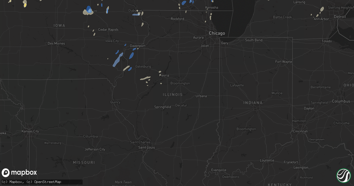
Hail Map in Illinois on July 9, 2020
Get this storm
July 9 map
$229
one time, instant access
Download today. No call, no setup
Keep the $229
Bought the map and want the full workflow? Apply the entire $229 to a subscription within 7 days. None of it is wasted.
Every map, not just this one
This buys you this map. Subscription and you get every map we run, in the markets you choose from a few cities to whole states to nationwide. Plus real-time alerts the moment a storm fires.
Contact data
Name, contact info, occupancy, even credit band for addresses in the footprint. You go from where it hit to who to call.
Become the source they trust
Unlimited branding weather history reports on demand. You already have the documented answer ready for the property owner, and you are the one who showed up with it.
Property data and RoofTrace estimates
Pull up any address you have got, its value and the exact code rules for that jurisdiction, straight from One Click Code. Then RoofTrace estimates the squares, pitch, and roof value, priced the way you price.
Storm reports in Illinois
Illinois
| Date | Description |
|---|---|
| 07/09/20206:48 PM CDT | A large tree limb was blown down. Photo shared on facebook. Time estimated. |
| 07/09/20206:41 PM CDT | Large tree limb blown down. Photo shared on facebook. Time estimated. |
| 07/09/20206:23 PM CDT | Highway sign blown over and damage to a corn field... Likely due to microburst. Picture from social media. Time estimated from radar. |
| 07/09/20206:21 PM CDT | Large tree branch down due to strong winds in andalusia... Report/picture from social media. Time estimated from radar. |
| 07/09/20206:19 PM CDT | Photo from social media showing a downed power pole in aledo; lp tank next to it was also blown over with damage to corn nearby. Time estimated from radar. |
| 07/09/20205:59 PM CDT | Social media picture of a large tree snapped in joy due to thunderstorm winds. Time estimated from radar. |
| 07/09/20205:58 PM CDT | Corrects previous tstm wnd dmg report from 1 se joy. Received a photo from social media of a field of corn blown over... Likely due to microburst from storms. Time esti |
| 07/09/20204:58 PM CDT | Received a photo from social media of a field of corn blown over... Likely due to microburst from storms. Time estimated from radar. |
| 07/09/20204:40 PM CDT | A few trees down on highway 20 near menominee. Time estimated from radar. |
| 07/09/20204:16 AM CDT | At 915 PM CDT, a severe thunderstorm was located near Easton, or 7 miles east of Havana, moving east at 45 mph. HAZARD...60 mph wind gusts. SOURCE...Radar indicated. IMPACT...Expect damage to roofs, siding, and trees. Locations impacted include... Mason City, Delavan, Manito, Hopedale, Green Valley, San Jose, Emden, Easton and Forest City.This includes Interstate 155 between mile markers 10 and 18. |
| 07/09/20203:41 AM CDT | At 841 PM CDT, severe thunderstorms were located along a line extending from Princeville to St. David to near Ipava, moving east at 30 mph. HAZARD...60 mph wind gusts. SOURCE...Radar indicated. IMPACT...Expect damage to roofs, siding, and trees. Locations impacted include... Peoria, Canton, Havana, Lewistown, Bartonville, Chillicothe, West Peoria, Bellevue, Princeville, Rome, Manito, Dunlap, Hanna City, Glasford, Trivoli, St. David, Spring Bay, Kickapoo, Peoria Heights and Norwood.This includes the following highways... Interstate 474 between mile markers 0 and 7. Interstate 74 between mile markers 76 and 92. |
| 07/09/20202:38 AM CDT | At 738 PM CDT, severe thunderstorms were located along a line extending from Altona to near Prairie City, moving northeast at 40 mph. HAZARD...60 mph wind gusts. SOURCE...Radar indicated. IMPACT...Expect damage to roofs, siding, and trees. Locations impacted include... Canton, Abingdon, Knoxville, Farmington, Elmwood, Princeville, Wyoming, Cuba, Toulon, Hanna City, Glasford, Trivoli, Osceola, Brimfield, Avon, Oneida, Yates City, St. David, Williamsfield and Altona.This includes Interstate 74 between mile markers 50 and 80. |
| 07/09/20202:24 AM CDT | At 723 PM CDT, a severe thunderstorm was located over Little Swan Lake, or 13 miles northeast of Macomb, moving east at 25 mph. HAZARD...60 mph wind gusts and quarter size hail. SOURCE...Radar indicated. IMPACT...Hail damage to vehicles is expected. Expect wind damage to roofs, siding, and trees. Locations impacted include... Macomb, Bushnell, Roseville, Avon, Blandinsville, Good Hope, Prairie City, Sciota, Little Swan Lake, Walnut Grove, Greenbush, Macomb Municipal Airport, Scottsburg, Swan Creek, Youngstown, Prairie City Airport and Spring Lake. |
| 07/09/20202:14 AM CDT | At 713 PM CDT, a severe thunderstorm was located near Monmouth, moving northeast at 35 mph. HAZARD...60 mph wind gusts and quarter size hail. SOURCE...Radar indicated. IMPACT...Hail damage to vehicles is expected. Expect wind damage to roofs, siding, and trees. Locations impacted include... Monmouth, Coldbrook, Berwick, Monmouth Municipal Airport and Cameron. |
| 07/09/20202:04 AM CDT | At 704 PM CDT, a severe thunderstorm was located near Monmouth, moving east at 25 mph. HAZARD...60 mph wind gusts and quarter size hail. SOURCE...Radar indicated. IMPACT...Hail damage to vehicles is expected. Expect wind damage to roofs, siding, and trees. Locations impacted include... Monmouth, Coldbrook, Ormonde, Gerlaw, Monmouth Municipal Airport and Cameron. |
| 07/09/20202:01 AM CDT | At 701 PM CDT, severe thunderstorms were located along a line extending from near Alpha to Roseville, moving east at 30 mph. HAZARD...60 mph wind gusts and penny size hail. SOURCE...Radar indicated. IMPACT...Expect damage to roofs, siding, and trees. Locations impacted include... Galesburg, Abingdon, Knoxville, Wataga, Oneida, Yates City, Williamsfield, Altona, Victoria, Maquon, Rio, Gilson, East Galesburg, Henderson, St. Augustine, Snake Den Hollow, Galesburg Airport, Dahinda and Delong.This includes Interstate 74 between mile markers 34 and 66. |
| 07/09/20201:52 AM CDT | At 652 PM CDT, severe thunderstorms were located along a line extending from near Potter Lake to near Kenosha, moving northeast at 30 mph. HAZARD...60 mph wind gusts and penny size hail. SOURCE...Radar indicated. IMPACT...Expect damage to roofs, siding, and trees. Locations impacted include... Milwaukee, Kenosha, Racine, Waukesha, West Allis, Wauwatosa, New Berlin, Brookfield, Greenfield, Oak Creek, Mount Pleasant, Muskego, South Milwaukee, Pleasant Prairie, Cudahy, Greendale, Pewaukee, St. Francis, Hales Corners and Mukwonago.This includes the following Locations Milwaukee County SportsComplex, Milkman Stadium, Southridge Mall, Boerner Botanical Gardens,General Mitchell International Airport, Froedert & the MedicalCollege, Fiserv Forum, and Mayfair Mall. |
| 07/09/202012:35 AM CDT | At 535 PM CDT, severe thunderstorms were located along a line extending from Wilton to near Eliza, moving northeast at 45 mph. HAZARD...60 mph wind gusts and quarter size hail. SOURCE...Radar indicated. IMPACT...Hail damage to vehicles is expected. Expect wind damage to roofs, siding, and trees. Locations impacted include... Davenport, Rock Island, Bettendorf, Muscatine, Durant, Eldridge, Wilton, Walcott, Blue Grass, Buffalo, Andalusia, Fruitland, Long Grove, Grand Mound, Calamus, Eliza, Donahue, Atalissa, Fairport and Montpelier.This includes the following highways... Interstate 74 in Iowa between mile markers 1 and 3. Interstate 80 in Iowa between mile markers 270 and 303. Interstate 280 between mile markers 1 and 10. |
| 07/09/202012:08 AM CDT | Power poles and power lines down. |
| 07/09/202012:08 AM CDT | At 508 PM CDT, severe thunderstorms were located along a line extending from near Conesville to Morning Sun, moving northeast at 35 mph. HAZARD...60 mph wind gusts and quarter size hail. SOURCE...Radar indicated. IMPACT...Hail damage to vehicles is expected. Expect wind damage to roofs, siding, and trees. Locations impacted include... Muscatine, Wapello, Columbus Junction, Wilton, Fruitland, Morning Sun, Millersburg, New Boston, Grandview, Conesville, Eliza, Joy, Letts, Atalissa, Oakville, Toolesboro, Illinois City, Mannon, Fredonia and Cranston.This includes Interstate 80 in Iowa between mile markers 267 and 273. |
| 07/09/202012:06 AM CDT | Crop damage and tree branches broken off. |
| 07/08/20209:12 PM CDT | Several limbs down across havana. One was large enough to knock a meter off a house. Most of the downed limbs were 2-3 inches in diameter. |
| 07/08/20209:00 PM CDT | Large tree blocking the road |
| 07/08/20208:50 PM CDT | Trees down and crops damaged |
| 07/08/20208:20 PM CDT | Branch size around 10 inches |
| 07/08/20208:15 PM CDT | Powerline down on the road. Report relayed by broadcast media. |
| 07/08/20207:55 PM CDT | Crop damage |
| 07/08/20207:49 PM CDT | Wind gusts estimated to 60 mph with 2 inch tree limbs blown down. |
| 07/08/20207:40 PM CDT | Reported several 2 to 3 inch diameter branches down. |
| 07/08/20207:10 PM CDT | Several photos shared on social media of trees down in elgin. Time estimated by radar. |
| 07/08/20207:08 PM CDT | Trees down and steel pier damaged in south elgin. Time estimated by radar. |
| 07/08/20207:08 PM CDT | Delayed report... Spotter reported 2 to 3 inch diameter tree limbs down and corn flattened or broken off. Time is estimated using radar. |
| 07/08/20207:03 PM CDT | A large tree limb was blown down across a road. Photo shared on twitter. Time estimated. |
All States Impacted by Hail Map on July 9, 2020
Cities Impacted by Hail Map on July 9, 2020
- Iliff, CO
- Peetz, CO
- Cedar Falls, IA
- Dike, IA
- Hudson, IA
- Ashby, NE
- Hyannis, NE
- Merriman, NE
- Bingham, NE
- Vale, SD
- Sturgis, SD
- Whitewood, SD
- Bayard, NE
- Dalton, NE
- Broadwater, NE
- Bridgeport, NE
- Dickens, TX
- Paducah, TX
- Newell, SD
- Knoxville, TN
- Mapleton, ME
- Morrow, OH
- South Lebanon, OH
- Memphis, TX
- Rozet, WY
- Bennett, CO
- Strasburg, CO
- Cozad, NE
- Brady, NE
- Gothenburg, NE
- Spragueville, IA
- Bellevue, IA
- Preston, IA
- Ellsworth, NE
- Watkins, CO
- Bluff City, KS
- Caldwell, KS
- Medford, OK
- Freeport, KS
- Stoneham, CO
- Potter, NE
- Custer, SD
- Fountain, MI
- Branch, MI
- Wheatland, WY
- Bertrand, NE
- Owatonna, MN
- Bagley, WI
- Byers, CO
- Allen, SD
- Johnson Creek, WI
- Jefferson, WI
- Lake Mills, WI
- Crawford, NE
- Lakeside, NE
- Gillette, WY
- Whitney, NE
- Hermosa, SD
- Keystone, SD
- Commerce City, CO
- Brighton, CO
- Henderson, CO
- Lewiston, MI
- Beulah, WY
- Grenola, KS
- Latham, KS
- Norwalk, OH
- Belle Fourche, SD
- Aladdin, WY
- Spearfish, SD
- Sundance, WY
- Moorcroft, WY
- Kensett, IA
- Saint Ansgar, IA
- Northwood, IA
- Grafton, IA
- New Raymer, CO
- Merino, CO
- Ashland, ME
- Neenah, WI
- Deer Trail, CO
- Pine Ridge, SD
- Harrison, NE
- Marsland, NE
- Saint Cloud, WI
- Bellevue, OH
- Orchard, CO
- Kersey, CO
- Roggen, CO
- Sycamore, PA
- Graysville, PA
- North Platte, NE
- Byron Center, MI
- Lyons, KS
- Little River, KS
- Upton, WY
- Waldron, KS
- Laurens, IA
- Pocahontas, IA
- Rockford, MI
- Ada, MI
- Belmont, MI
- Morley, MI
- Sand Lake, MI
- Pierson, MI
- Howard City, MI
- Luzerne, MI
- Dexter, MI
- Edgemont, SD
- Chadron, NE
- Oelrichs, SD
- Hemingford, NE
- Alliance, NE
- Guernsey, WY
- Midland, SD
- Wichita, KS
- Sheffield, IA
- East Troy, WI
- Childress, TX
- Matador, TX
- Cambridge Springs, PA
- Union City, PA
- Grover, CO
- Tryon, NE
- Hershey, NE
- Lu Verne, IA
- Livermore, IA
- Corwith, IA
- Hardy, IA
- Renwick, IA
- Waynesfield, OH
- Wapakoneta, OH
- Murdock, KS
- Cheney, KS
- Merrillan, WI
- Alma Center, WI
- Canton, IL
- Arthur, NE
- Sutherland, NE
- Oregon, WI
- Ellis, KS
- Kanawha, IA
- Whitman, NE
- Limon, CO
- Padroni, CO
- Denver, CO
- Aurora, CO
- Bay Port, MI
- Sebewaing, MI
- Agate, CO
- Elkhorn, WI
- Grand Rapids, OH
- Rapid City, SD
- Claflin, KS
- Holyrood, KS
- Cee Vee, TX
- Tell, TX
- Mazeppa, MN
- Garden, MI
- Garner, IA
- Britt, IA
- Goodell, IA
- Klemme, IA
- Hay Springs, NE
- Mio, MI
- Burrton, KS
- Fairburn, SD
- Sedgwick, CO
- Ovid, CO
- Fonda, IA
- Irons, MI
- Custer, MI
- Patten, ME
- Sandusky, OH
- Monroeville, OH
- Watson, AR
- Alta, IA
- Black Earth, WI
- Mazomanie, WI
- New Underwood, SD
- Union Center, SD
- Port Clinton, OH
- Merrimac, WI
- Wall, SD
- Wasta, SD
- Howes, SD
- Enning, SD
- Brighton, MI
- Milford, MI
- South Lyon, MI
- Rockford, TN
- Muskego, WI
- Brooksville, MS
- Torrington, WY
- Winthrop, IA
- Coopersville, MI
- Marne, MI
- Merigold, MS
- Cleveland, MS
- Butler, KY
- California, KY
- Oshkosh, NE
- Bushton, KS
- Brooklyn, WI
- Belleville, WI
- Conway Springs, KS
- North Fairfield, OH
- Willard, OH
- Venedocia, OH
- Williamstown, KY
- Dry Ridge, KY
- Havelock, IA
- Rock Island, IL
- Milan, IL
- Summers, AR
- Westville, OK
- Mineral Point, WI
- Julesburg, CO
- Lexington, NE
- Otis, KS
- Bison, KS
- La Crosse, KS
- Albert, KS
- Larned, KS
- Rush Center, KS
- Pawnee Rock, KS
- Maineville, OH
- Kings Mills, OH
- Lebanon, OH
- Cresco, IA
- New Lisbon, WI
- Necedah, WI
- Waterloo, IA
- Argonia, KS
- Danville, KS
- Maryville, TN
- Keenesburg, CO
- Bokoshe, OK
- Shady Point, OK
- Poteau, OK
- Cameron, OK
- Dix, NE
- Spiro, OK
- Galena, IL
- Nevada, OH
- Marion, OH
- Dousman, WI
- Carpenter, WY
- Lenoir City, TN
- La Salle, CO
- Hudson, CO
- Fort Lupton, CO
- Haven, KS
- Wayland, IA
- Lake Cormorant, MS
- Burlington, IA
- Oquawka, IL
- Gladstone, IL
- Morral, OH
- Belle Plaine, IA
- Luzerne, IA
- Marengo, IA
- Ladora, IA
- Victor, IA
- Ogallah, KS
- Hayes, SD
- Lake Villa, IL
- Sandy Lake, PA
- Grand Rapids, MI
- Blairsville, GA
- Harper, KS
- Scenic, SD
- Kenosha, WI
- Okaton, SD
- Lake Zurich, IL
- Elm Creek, NE
- Martin, SD
- Imlay City, MI
- Capac, MI
- Hartville, WY
- Humboldt, IA
- Rutland, IA
- Clear Lake, IA
- Goldfield, IA
- Thornton, IA
- Meservey, IA
- Hays, KS
- Nash, OK
- Wakita, OK
- Chelsea, MI
- Cambridge, WI
- Saint Francis, WI
- South Milwaukee, WI
- Cudahy, WI
- Milwaukee, WI
- Oak Creek, WI
- Keystone, IA
- Dougherty, IA
- Claremont, MN
- Oxford, KS
- Aurelia, IA
- Lima, OH
- Buckland, OH
- Delphos, OH
- Roscommon, MI
- Elwood, NE
- Fairmont, WV
- Shinnston, WV
- Bridgeport, WV
- Liberty, IN
- Luther, MI
- Maxwell, NE
- Leon, KS
- Pekin, IL
- Green Valley, IL
- Wellington, TX
- Hutchinson, KS
- Pretty Prairie, KS
- Lincoln, AR
- Canehill, AR
- Cuba, IL
- Sussex, WI
- Pewaukee, WI
- Bunker Hill, KS
- Dorrance, KS
- Wilson, KS
- Corry, PA
- Spartansburg, PA
- Shelby, MS
- Duncan, MS
- Fairbank, IA
- Frankfort, KY
- Indianola, PA
- Cheswick, PA
- Allison Park, PA
- Pittsburgh, PA
- Wanblee, SD
- Long Valley, SD
- Atlanta, MI
- West Mansfield, OH
- Raymond, OH
- Fort Atkinson, WI
- Geneseo, KS
- Boyle, MS
- Buhler, KS
- Mound Bayou, MS
- Lodi, WI
- Mullen, NE
- Stockbridge, MI
- Castalia, OH
- Clyde, OH
- Randolph, WI
- Cambria, WI
- Wellington, KS
- Waukegan, IL
- Zion, IL
- Whitmore Lake, MI
- Ellinwood, KS
- Mills River, NC
- Horse Shoe, NC
- Masonville, IA
- Lamont, IA
- Portage, WI
- Lance Creek, WY
- Ellijay, GA
- Unionville, MI
- Hanna City, IL
- Correctionville, IA
- Marshfield, WI
- Cashton, WI
- Westby, WI
- Van Wert, OH
- Ohio City, OH
- Bucyrus, OH
- London Mills, IL
- Farmington, IL
- Avon, IL
- Fairview, IL
- Bushnell, IL
- Ellisville, IL
- Prairie City, IL
- Racine, WI
- Cottonwood, ID
- Whitewater, WI
- Elkhart Lake, WI
- Kiel, WI
- Evansdale, IA
- Grandville, MI
- Wyoming, MI
- Presque Isle, ME
- Lewistown, IL
- Edgerton, WI
- Milton, WI
- Kingman, KS
- Norwich, KS
- Raymond, IA
- Palms, MI
- Deckerville, MI
- Toxey, AL
- Lewisburg, OH
- Mount Hope, KS
- Gunnison, MS
- Poplar Grove, IL
- Sharon, WI
- Capron, IL
- Crab Orchard, TN
- Rockwood, TN
- Salina, OK
- Spavinaw, OK
- Lake Forest, IL
- Great Lakes, IL
- Lake Bluff, IL
- North Chicago, IL
- Clutier, IA
- Rushville, NE
- Winfield, KS
- Plain, WI
- Lone Rock, WI
- Loganville, WI
- Hillpoint, WI
- Spring Green, WI
- Anthony, KS
- Maynard, IA
- Darlington, WI
- Hoisington, KS
- Palmyra, WI
- Mukwonago, WI
- Eagle, WI
- Oconomowoc, WI
- Stoneboro, PA
- Gibsonburg, OH
- Lindsey, OH
- Janesville, WI
- Beloit, WI
- Reinbeck, IA
- La Porte City, IA
- Sullivan, WI
- Watertown, WI
- Helenville, WI
- Hazel Green, WI
- East Dubuque, IL
- Deadwood, SD
- Arena, WI
- Ironton, OH
- Princeville, IL
- Dunlap, IL
- Edwards, IL
- Brimfield, IL
- Twinsburg, OH
- Stapleton, NE
- Plymouth, OH
- Solon, OH
- McCracken, KS
- Schoenchen, KS
- Rubicon, WI
- Ordway, CO
- Jasper, GA
- Fort Pierre, SD
- Milesville, SD
- Middle Point, OH
- Biggsville, IL
- Joy, IL
- Reynolds, IL
- Aledo, IL
- Andalusia, IL
- Taylor Ridge, IL
- Crook, CO
- Thornton, CO
- Venango, NE
- Sauk City, WI
- Prairie Du Sac, WI
- Dane, WI
- Deforest, WI
- Arlington, WI
- Madison, WI
- Stoughton, WI
- Avalon, WI
- Hartford, WI
- Ixonia, WI
- Janesville, IA
- Oelwein, IA
- Hazleton, IA
- Elgin, IA
- Fayette, IA
- West Union, IA
- Ossian, IA
- Castalia, IA
- Clermont, IA
- Waukon, IA
- Postville, IA
- La Motte, IA
- Zwingle, IA
- Dubuque, IA
- Grandview, IA
- Letts, IA
- Yarmouth, IA
- Mount Union, IA
- Mount Pleasant, IA
- Muscatine, IA
- Wapello, IA
- Morning Sun, IA
- New London, IA
- Columbus Junction, IA
- Winfield, IA
- Conesville, IA
- Moscow, IA
- Wilton, IA
- Bentonville, AR
- Siloam Springs, AR
- Rogers, AR
- Cave Springs, AR
- Farmington, AR
- Lowell, AR
- Gentry, AR
- Fayetteville, AR
- Springdale, AR
- Uniontown, AR
- Evansville, AR
- Natural Dam, AR
- Rudy, AR
- Van Buren, AR
- Cedarville, AR
- Stilwell, OK
- Odessa, NE
- Willow Island, NE
- Overton, NE
- Kearney, NE


