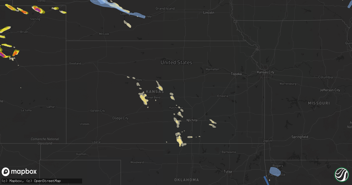
Hail Map in Kansas on July 9, 2020
Get this storm
July 9 map
$229
one time, instant access
Download today. No call, no setup
Keep the $229
Bought the map and want the full workflow? Apply the entire $229 to a subscription within 7 days. None of it is wasted.
Every map, not just this one
This buys you this map. Subscription and you get every map we run, in the markets you choose from a few cities to whole states to nationwide. Plus real-time alerts the moment a storm fires.
Contact data
Name, contact info, occupancy, even credit band for addresses in the footprint. You go from where it hit to who to call.
Become the source they trust
Unlimited branding weather history reports on demand. You already have the documented answer ready for the property owner, and you are the one who showed up with it.
Property data and RoofTrace estimates
Pull up any address you have got, its value and the exact code rules for that jurisdiction, straight from One Click Code. Then RoofTrace estimates the squares, pitch, and roof value, priced the way you price.
Storm reports in Kansas
Kansas
| Date | Description |
|---|---|
| 07/09/20207:45 AM CDT | At 1244 AM CDT, severe thunderstorms were located along a line extending from 9 miles east of Mahaska to 3 miles northwest of Vining to 5 miles northeast of Delphos, moving southeast at 50 mph. HAZARD...70 mph wind gusts and penny size hail. SOURCE...Radar indicated. IMPACT...Expect considerable tree damage. Damage is likely to mobile homes, roofs, and outbuildings. Locations impacted include... Clay Center, Washington, Clyde, Hanover, Clifton, Miltonvale, Glasco, Linn, Delphos, Greenleaf, Morganville, Barnes, Morrowville, Green, Palmer, Haddam, Agenda, Aurora, Vining and Oak Hill. |
| 07/09/20207:12 AM CDT | At 1212 AM CDT, severe thunderstorms were located along a line extending from Courtland to near Cawker City to near Alton, moving southeast at 30 mph. HAZARD...60 mph wind gusts and penny size hail. SOURCE...Radar indicated. IMPACT...Expect damage to roofs, siding, and trees. Locations impacted include... Beloit, Smith Center, Osborne, Downs, Mankato, Cawker City, Glen Elder, Jewell, Lebanon, Tipton, Burr Oak, Gaylord, Portis, Alton, Esbon, Asherville, Formoso, Simpson, Ionia and Randall. |
| 07/09/20207:07 AM CDT | At 1206 AM CDT, severe thunderstorms were located along a line extending from near Benedict to near Byron, moving east at 50 mph. HAZARD...70 mph wind gusts. SOURCE...Radar indicated. IMPACT...Expect considerable tree damage. Damage is likely to mobile homes, roofs, and outbuildings. Locations impacted include... Seward, Crete, Fairbury, Milford, Wilber, Friend, Utica, Dorchester, De Witt, Plymouth, Beaver Crossing, Diller, Staplehurst, Western, Garland, Pleasant Dale, Bee, Daykin, Goehner and Cordova.This includes Interstate 80 in Nebraska between mile markers 366 and388. |
| 07/09/20207:04 AM CDT | At 1204 AM CDT, severe thunderstorms were located along a line extending from near Ruskin to 4 miles south of Republic to near Randall, moving southeast at 55 mph. HAZARD...70 mph wind gusts and penny size hail. SOURCE...Radar indicated. IMPACT...Expect considerable tree damage. Damage is likely to mobile homes, roofs, and outbuildings. Locations impacted include... Concordia, Belleville, Clyde, Clifton, Miltonvale, Glasco, Cuba, Morrowville, Palmer, Haddam, Munden, Narka, Mahaska, Agenda, Aurora and Vining. |
| 07/09/20206:34 AM CDT | A local report indicates 60 MPH wind near 1 SSE FREEPORT |
| 07/08/202011:13 PM CDT | At 412 AM CDT, severe thunderstorms were located along a line extending from 3 miles west of Princeton to 6 miles east of New Strawn to 3 miles north of Madison, moving southeast at 45 mph. HAZARD...60 mph wind gusts. SOURCE...Radar indicated. IMPACT...Expect damage to roofs, siding, and trees. Locations impacted include... Garnett, Burlington, Waverly, Olpe, Richmond, Colony, New Strawn, Hartford, Gridley, Greeley, Westphalia, Kincaid, Lone Elm, Harris, John Redmond Reservoir and Le Roy. |
| 07/08/202010:19 PM CDT | At 318 AM CDT, severe thunderstorms were located along a line extending from near Nortonville to 3 miles northeast of Grantville to 4 miles south of Auburn, moving east at 50 mph. HAZARD...60 mph wind gusts. SOURCE...Automated weather station at Billard Field in Topeka reported a 60 MPH wind gusts. IMPACT...Expect damage to roofs, siding, and trees. Locations impacted include... Topeka, Lawrence, Baldwin City, Carbondale, Valley Falls, Oskaloosa, Tecumseh, Eudora, Richland, Wellsville, Auburn, Overbrook, Perry, McLouth, Meriden, Ozawkie, Nortonville, Lecompton, Clinton and Winchester.This includes Kansas Turnpike between mile markers 165 and 205. |
| 07/08/202010:15 PM CDT | At 313 AM CDT, severe thunderstorm outflow boundary was located along a line extending from 3 miles southeast of Overbrook to near Melvern Lake to 9 miles west of Olpe, moving southeast at 40 mph. Thunderstorms trailing the outflow boundary are also moving southeast at 40 MPH and may produce 60 mph wind gusts. HAZARD...60 mph wind gusts. SOURCE...Radar indicated. IMPACT...Expect damage to roofs, siding, and trees. Locations impacted include... Emporia, Ottawa, Garnett, Osage City, Burlington, Wellsville, Lyndon, Centropolis, Lebo, Burlingame, Americus, Pomona, Scranton, Waverly, Olpe, Richmond, Williamsburg, New Strawn, Quenemo and Melvern.This includes the following highways... Interstate 35 between mile markers 128 and 198. Kansas Turnpike between mile markers 116 and 164. |
| 07/08/20209:45 PM CDT | At 244 AM CDT, severe thunderstorms were located along a line extending from 5 miles southeast of Latimer to 6 miles northwest of Durham, moving southeast at 50 mph. HAZARD...60 mph wind gusts and quarter size hail. SOURCE...Radar indicated. IMPACT...Hail damage to vehicles is expected. Expect wind damage to roofs, siding, and trees. Locations impacted include... Hillsboro, Marion, Florence, Goessel, Lincolnville, Ramona, Lehigh, Durham, Tampa, Lost Springs, Elmdale, Cedar Point, Hymer, Marion Lake, Pilsen and Tallgrass Prairie Preserve. |
| 07/08/20209:40 PM CDT | At 240 AM CDT, severe thunderstorms were located along a line extending from Craig to near Willis to near Hoyt, moving east at 55 mph. HAZARD...60 mph wind gusts. SOURCE...Radar indicated. IMPACT...Expect damage to roofs, siding, and trees. Locations impacted include... Maryville, Savannah, Tarkio, Mound City, Rock Port, Oregon, Fairfax, Burlington Junction, Hopkins, Maitland, Amazonia, Skidmore, Forest City, Craig, Fillmore, Rockport, Barnard, Bolckow, Graham and Clearmont.This includes the following highways... Interstate 29 between mile markers 57 and 123. Interstate 229 between mile markers 12 and 14. |
| 07/08/20209:30 PM CDT | At 230 AM CDT, severe thunderstorms were located along a line extending from near Falls City to near Maple Hill, moving east at 50 mph. HAZARD...60 mph wind gusts. SOURCE...Radar indicated. IMPACT...Expect damage to roofs, siding, and trees. Locations impacted include... Olathe, St. Joseph, Shawnee, Lenexa, Leavenworth, Lansing, Atchison, Bonner Springs, De Soto, Parkville, Tonganoxie, Platte City, Basehor, Edwardsville, Weston, Wathena, Elwood, Highland, Troy and Kansas City.This includes the following highways... Interstate 70 in Kansas between mile markers 410 and 413. Interstate 29 between mile markers 14 and 51. Interstate 435 between mile markers 11 and 34. Interstate 229 between mile markers 0 and 9. Kansas Turnpike between mile markers 206 and 226. |
| 07/08/20209:12 PM CDT | At 211 AM CDT, severe thunderstorms were located along a line extending from 4 miles west of Peru to near Bern, moving east at 25 mph. HAZARD...60 mph wind gusts. SOURCE...Radar indicated. IMPACT...Expect damage to roofs, siding, and trees. Locations impacted include... Falls City, Auburn, Pawnee City, Humboldt, Peru, Johnson, Table Rock, Verdon, Stella, Shubert, Rulo, Nemaha, Du Bois, Dawson, Brownville, Salem, Brock, Julian, Preston and Barada. |
| 07/08/20209:09 PM CDT | At 209 AM CDT, severe thunderstorms were located along a line extending from near Auburn to near Oneida to 7 miles south of Onaga, moving east at 55 mph. HAZARD...60 mph wind gusts. SOURCE...Radar indicated. IMPACT...Expect damage to roofs, siding, and trees. Locations impacted include... Maryville, Savannah, Tarkio, Mound City, Rock Port, Oregon, Fairfax, Burlington Junction, Hopkins, Maitland, Amazonia, Skidmore, Forest City, Craig, Fillmore, Rockport, Barnard, Bolckow, Graham and Clearmont.This includes the following highways... Interstate 29 between mile markers 56 and 123. Interstate 229 between mile markers 11 and 14. |
| 07/08/20208:18 PM CDT | At 117 AM CDT, severe thunderstorms were located along a line extending from near Sterling to near Oketo, moving east at 50 mph. HAZARD...75 mph wind gusts. SOURCE...Radar indicated. IMPACT...Expect considerable tree damage. Damage is likely to mobile homes, roofs, and outbuildings. Locations impacted include... Falls City, Auburn, Tecumseh, Pawnee City, Humboldt, Peru, Sterling, Johnson, Cook, Table Rock, Verdon, Summerfield, Stella, Shubert, Rulo, Nemaha, Du Bois, Dawson, Brownville and Salem. |
| 07/08/20208:07 PM CDT | At 107 AM CDT, severe thunderstorms were located along a line extending from 5 miles southeast of Odell to 4 miles north of Green to 4 miles northeast of Ada, moving east at 50 mph. HAZARD...60 mph wind gusts and penny size hail. SOURCE...Radar indicated. IMPACT...Expect damage to roofs, siding, and trees. Locations impacted include... Marysville, Minneapolis, Blue Rapids, Wakefield, Riley, Frankfort, Waterville, Bennington, Milford, Leonardville, Axtell, Tescott, Olsburg, Beattie, Randolph, Summerfield, Green, Culver, Wells and Manchester. |
All States Impacted by Hail Map on July 9, 2020
Cities Impacted by Hail Map on July 9, 2020
- Iliff, CO
- Peetz, CO
- Cedar Falls, IA
- Dike, IA
- Hudson, IA
- Ashby, NE
- Hyannis, NE
- Merriman, NE
- Bingham, NE
- Vale, SD
- Sturgis, SD
- Whitewood, SD
- Bayard, NE
- Dalton, NE
- Broadwater, NE
- Bridgeport, NE
- Dickens, TX
- Paducah, TX
- Newell, SD
- Knoxville, TN
- Mapleton, ME
- Morrow, OH
- South Lebanon, OH
- Memphis, TX
- Rozet, WY
- Bennett, CO
- Strasburg, CO
- Cozad, NE
- Brady, NE
- Gothenburg, NE
- Spragueville, IA
- Bellevue, IA
- Preston, IA
- Ellsworth, NE
- Watkins, CO
- Bluff City, KS
- Caldwell, KS
- Medford, OK
- Freeport, KS
- Stoneham, CO
- Potter, NE
- Custer, SD
- Fountain, MI
- Branch, MI
- Wheatland, WY
- Bertrand, NE
- Owatonna, MN
- Bagley, WI
- Byers, CO
- Allen, SD
- Johnson Creek, WI
- Jefferson, WI
- Lake Mills, WI
- Crawford, NE
- Lakeside, NE
- Gillette, WY
- Whitney, NE
- Hermosa, SD
- Keystone, SD
- Commerce City, CO
- Brighton, CO
- Henderson, CO
- Lewiston, MI
- Beulah, WY
- Grenola, KS
- Latham, KS
- Norwalk, OH
- Belle Fourche, SD
- Aladdin, WY
- Spearfish, SD
- Sundance, WY
- Moorcroft, WY
- Kensett, IA
- Saint Ansgar, IA
- Northwood, IA
- Grafton, IA
- New Raymer, CO
- Merino, CO
- Ashland, ME
- Neenah, WI
- Deer Trail, CO
- Pine Ridge, SD
- Harrison, NE
- Marsland, NE
- Saint Cloud, WI
- Bellevue, OH
- Orchard, CO
- Kersey, CO
- Roggen, CO
- Sycamore, PA
- Graysville, PA
- North Platte, NE
- Byron Center, MI
- Lyons, KS
- Little River, KS
- Upton, WY
- Waldron, KS
- Laurens, IA
- Pocahontas, IA
- Rockford, MI
- Ada, MI
- Belmont, MI
- Morley, MI
- Sand Lake, MI
- Pierson, MI
- Howard City, MI
- Luzerne, MI
- Dexter, MI
- Edgemont, SD
- Chadron, NE
- Oelrichs, SD
- Hemingford, NE
- Alliance, NE
- Guernsey, WY
- Midland, SD
- Wichita, KS
- Sheffield, IA
- East Troy, WI
- Childress, TX
- Matador, TX
- Cambridge Springs, PA
- Union City, PA
- Grover, CO
- Tryon, NE
- Hershey, NE
- Lu Verne, IA
- Livermore, IA
- Corwith, IA
- Hardy, IA
- Renwick, IA
- Waynesfield, OH
- Wapakoneta, OH
- Murdock, KS
- Cheney, KS
- Merrillan, WI
- Alma Center, WI
- Canton, IL
- Arthur, NE
- Sutherland, NE
- Oregon, WI
- Ellis, KS
- Kanawha, IA
- Whitman, NE
- Limon, CO
- Padroni, CO
- Denver, CO
- Aurora, CO
- Bay Port, MI
- Sebewaing, MI
- Agate, CO
- Elkhorn, WI
- Grand Rapids, OH
- Rapid City, SD
- Claflin, KS
- Holyrood, KS
- Cee Vee, TX
- Tell, TX
- Mazeppa, MN
- Garden, MI
- Garner, IA
- Britt, IA
- Goodell, IA
- Klemme, IA
- Hay Springs, NE
- Mio, MI
- Burrton, KS
- Fairburn, SD
- Sedgwick, CO
- Ovid, CO
- Fonda, IA
- Irons, MI
- Custer, MI
- Patten, ME
- Sandusky, OH
- Monroeville, OH
- Watson, AR
- Alta, IA
- Black Earth, WI
- Mazomanie, WI
- New Underwood, SD
- Union Center, SD
- Port Clinton, OH
- Merrimac, WI
- Wall, SD
- Wasta, SD
- Howes, SD
- Enning, SD
- Brighton, MI
- Milford, MI
- South Lyon, MI
- Rockford, TN
- Muskego, WI
- Brooksville, MS
- Torrington, WY
- Winthrop, IA
- Coopersville, MI
- Marne, MI
- Merigold, MS
- Cleveland, MS
- Butler, KY
- California, KY
- Oshkosh, NE
- Bushton, KS
- Brooklyn, WI
- Belleville, WI
- Conway Springs, KS
- North Fairfield, OH
- Willard, OH
- Venedocia, OH
- Williamstown, KY
- Dry Ridge, KY
- Havelock, IA
- Rock Island, IL
- Milan, IL
- Summers, AR
- Westville, OK
- Mineral Point, WI
- Julesburg, CO
- Lexington, NE
- Otis, KS
- Bison, KS
- La Crosse, KS
- Albert, KS
- Larned, KS
- Rush Center, KS
- Pawnee Rock, KS
- Maineville, OH
- Kings Mills, OH
- Lebanon, OH
- Cresco, IA
- New Lisbon, WI
- Necedah, WI
- Waterloo, IA
- Argonia, KS
- Danville, KS
- Maryville, TN
- Keenesburg, CO
- Bokoshe, OK
- Shady Point, OK
- Poteau, OK
- Cameron, OK
- Dix, NE
- Spiro, OK
- Galena, IL
- Nevada, OH
- Marion, OH
- Dousman, WI
- Carpenter, WY
- Lenoir City, TN
- La Salle, CO
- Hudson, CO
- Fort Lupton, CO
- Haven, KS
- Wayland, IA
- Lake Cormorant, MS
- Burlington, IA
- Oquawka, IL
- Gladstone, IL
- Morral, OH
- Belle Plaine, IA
- Luzerne, IA
- Marengo, IA
- Ladora, IA
- Victor, IA
- Ogallah, KS
- Hayes, SD
- Lake Villa, IL
- Sandy Lake, PA
- Grand Rapids, MI
- Blairsville, GA
- Harper, KS
- Scenic, SD
- Kenosha, WI
- Okaton, SD
- Lake Zurich, IL
- Elm Creek, NE
- Martin, SD
- Imlay City, MI
- Capac, MI
- Hartville, WY
- Humboldt, IA
- Rutland, IA
- Clear Lake, IA
- Goldfield, IA
- Thornton, IA
- Meservey, IA
- Hays, KS
- Nash, OK
- Wakita, OK
- Chelsea, MI
- Cambridge, WI
- Saint Francis, WI
- South Milwaukee, WI
- Cudahy, WI
- Milwaukee, WI
- Oak Creek, WI
- Keystone, IA
- Dougherty, IA
- Claremont, MN
- Oxford, KS
- Aurelia, IA
- Lima, OH
- Buckland, OH
- Delphos, OH
- Roscommon, MI
- Elwood, NE
- Fairmont, WV
- Shinnston, WV
- Bridgeport, WV
- Liberty, IN
- Luther, MI
- Maxwell, NE
- Leon, KS
- Pekin, IL
- Green Valley, IL
- Wellington, TX
- Hutchinson, KS
- Pretty Prairie, KS
- Lincoln, AR
- Canehill, AR
- Cuba, IL
- Sussex, WI
- Pewaukee, WI
- Bunker Hill, KS
- Dorrance, KS
- Wilson, KS
- Corry, PA
- Spartansburg, PA
- Shelby, MS
- Duncan, MS
- Fairbank, IA
- Frankfort, KY
- Indianola, PA
- Cheswick, PA
- Allison Park, PA
- Pittsburgh, PA
- Wanblee, SD
- Long Valley, SD
- Atlanta, MI
- West Mansfield, OH
- Raymond, OH
- Fort Atkinson, WI
- Geneseo, KS
- Boyle, MS
- Buhler, KS
- Mound Bayou, MS
- Lodi, WI
- Mullen, NE
- Stockbridge, MI
- Castalia, OH
- Clyde, OH
- Randolph, WI
- Cambria, WI
- Wellington, KS
- Waukegan, IL
- Zion, IL
- Whitmore Lake, MI
- Ellinwood, KS
- Mills River, NC
- Horse Shoe, NC
- Masonville, IA
- Lamont, IA
- Portage, WI
- Lance Creek, WY
- Ellijay, GA
- Unionville, MI
- Hanna City, IL
- Correctionville, IA
- Marshfield, WI
- Cashton, WI
- Westby, WI
- Van Wert, OH
- Ohio City, OH
- Bucyrus, OH
- London Mills, IL
- Farmington, IL
- Avon, IL
- Fairview, IL
- Bushnell, IL
- Ellisville, IL
- Prairie City, IL
- Racine, WI
- Cottonwood, ID
- Whitewater, WI
- Elkhart Lake, WI
- Kiel, WI
- Evansdale, IA
- Grandville, MI
- Wyoming, MI
- Presque Isle, ME
- Lewistown, IL
- Edgerton, WI
- Milton, WI
- Kingman, KS
- Norwich, KS
- Raymond, IA
- Palms, MI
- Deckerville, MI
- Toxey, AL
- Lewisburg, OH
- Mount Hope, KS
- Gunnison, MS
- Poplar Grove, IL
- Sharon, WI
- Capron, IL
- Crab Orchard, TN
- Rockwood, TN
- Salina, OK
- Spavinaw, OK
- Lake Forest, IL
- Great Lakes, IL
- Lake Bluff, IL
- North Chicago, IL
- Clutier, IA
- Rushville, NE
- Winfield, KS
- Plain, WI
- Lone Rock, WI
- Loganville, WI
- Hillpoint, WI
- Spring Green, WI
- Anthony, KS
- Maynard, IA
- Darlington, WI
- Hoisington, KS
- Palmyra, WI
- Mukwonago, WI
- Eagle, WI
- Oconomowoc, WI
- Stoneboro, PA
- Gibsonburg, OH
- Lindsey, OH
- Janesville, WI
- Beloit, WI
- Reinbeck, IA
- La Porte City, IA
- Sullivan, WI
- Watertown, WI
- Helenville, WI
- Hazel Green, WI
- East Dubuque, IL
- Deadwood, SD
- Arena, WI
- Ironton, OH
- Princeville, IL
- Dunlap, IL
- Edwards, IL
- Brimfield, IL
- Twinsburg, OH
- Stapleton, NE
- Plymouth, OH
- Solon, OH
- McCracken, KS
- Schoenchen, KS
- Rubicon, WI
- Ordway, CO
- Jasper, GA
- Fort Pierre, SD
- Milesville, SD
- Middle Point, OH
- Biggsville, IL
- Joy, IL
- Reynolds, IL
- Aledo, IL
- Andalusia, IL
- Taylor Ridge, IL
- Crook, CO
- Thornton, CO
- Venango, NE
- Sauk City, WI
- Prairie Du Sac, WI
- Dane, WI
- Deforest, WI
- Arlington, WI
- Madison, WI
- Stoughton, WI
- Avalon, WI
- Hartford, WI
- Ixonia, WI
- Janesville, IA
- Oelwein, IA
- Hazleton, IA
- Elgin, IA
- Fayette, IA
- West Union, IA
- Ossian, IA
- Castalia, IA
- Clermont, IA
- Waukon, IA
- Postville, IA
- La Motte, IA
- Zwingle, IA
- Dubuque, IA
- Grandview, IA
- Letts, IA
- Yarmouth, IA
- Mount Union, IA
- Mount Pleasant, IA
- Muscatine, IA
- Wapello, IA
- Morning Sun, IA
- New London, IA
- Columbus Junction, IA
- Winfield, IA
- Conesville, IA
- Moscow, IA
- Wilton, IA
- Bentonville, AR
- Siloam Springs, AR
- Rogers, AR
- Cave Springs, AR
- Farmington, AR
- Lowell, AR
- Gentry, AR
- Fayetteville, AR
- Springdale, AR
- Uniontown, AR
- Evansville, AR
- Natural Dam, AR
- Rudy, AR
- Van Buren, AR
- Cedarville, AR
- Stilwell, OK
- Odessa, NE
- Willow Island, NE
- Overton, NE
- Kearney, NE


