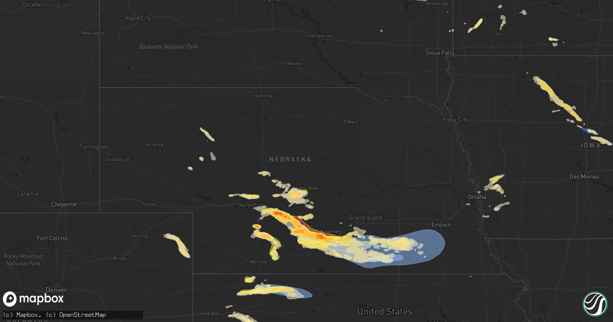
Hail Map in Nebraska on July 6, 2024
Get this storm
July 6 map
$229
one time, instant access
Download today. No call, no setup
Keep the $229
Bought the map and want the full workflow? Apply the entire $229 to a subscription within 7 days. None of it is wasted.
Every map, not just this one
This buys you this map. Subscription and you get every map we run, in the markets you choose from a few cities to whole states to nationwide. Plus real-time alerts the moment a storm fires.
Contact data
Name, contact info, occupancy, even credit band for addresses in the footprint. You go from where it hit to who to call.
Become the source they trust
Unlimited branding weather history reports on demand. You already have the documented answer ready for the property owner, and you are the one who showed up with it.
Property data and RoofTrace estimates
Pull up any address you have got, its value and the exact code rules for that jurisdiction, straight from One Click Code. Then RoofTrace estimates the squares, pitch, and roof value, priced the way you price.
Storm reports in Nebraska
Nebraska
| Date | Description |
|---|---|
| 07/06/20246:33 PM CDT | Tree branches down 6-8 inches in diameter. |
| 07/06/20246:25 PM CDT | A local report indicates 60 MPH wind near 1 NW Western |
| 07/06/20245:57 PM CDT | A couple of very large trees blown down in alexandria. Report relayed from nws omaha via their facebook page. Time estimated from radar. |
| 07/06/20245:53 PM CDT | Report from mping: 1-inch tree limbs broken; shingles blown off. |
| 07/06/20245:45 PM CDT | A local report indicates 1.50 inch wind near 1 NE Geneva |
| 07/06/20245:41 PM CDT | A local report indicates 60 MPH wind near 5 W Geneva |
| 07/06/20245:36 PM CDT | A local report indicates 68 MPH wind near 3 WSW Carleton |
| 07/06/20245:36 PM CDT | A local report indicates 79 MPH wind near 2 SSE Davenport |
| 07/06/20245:35 PM CDT | A local report indicates 63 MPH wind near 4 ESE Davenport |
| 07/06/20245:32 PM CDT | A local report indicates 60 MPH wind near 3 SW Carleton |
| 07/06/20245:30 PM CDT | A local report indicates 72 MPH wind near Davenport |
| 07/06/20245:28 PM CDT | A local report indicates 62 MPH wind near 3 WNW Davenport |
| 07/06/20245:26 PM CDT | Distribution power line and poles down with pivots turned over between road 315 and 316. Time estimated based on radar. |
| 07/06/20245:25 PM CDT | A local report indicates 59 MPH wind near 5 W Davenport |
| 07/06/20245:24 PM CDT | A local report indicates 68 MPH wind near 4 SE Edgar |
| 07/06/20245:21 PM CDT | Report from mping: 1-inch tree limbs broken; shingles blown off. |
| 07/06/20245:20 PM CDT | A local report indicates 58 MPH wind near 1 NNW Edgar |
| 07/06/20245:19 PM CDT | A local report indicates 74 MPH wind near 3 S Edgar |
| 07/06/20245:18 PM CDT | # miles nne of clay center em reports large trees down from storm. Time estimated from radar. |
| 07/06/20245:18 PM CDT | A local report indicates 68 MPH wind near 2 SE Edgar |
| 07/06/20245:15 PM CDT | Corrects previous tstm wnd gst report from 4 nnw edgar. Weather station reported a 60 mph wind gust. |
| 07/06/20245:14 PM CDT | Corrects previous tstm wnd gst report from 6 ese clay center. Estimated 60-70 mph winds with tree limb damage up to 8 inches in diameter. Dime sized hail around 530 pm. |
| 07/06/20245:14 PM CDT | Corrects previous tstm wnd dmg report from 6 ese clay center. Tree branches down 6-8 inches in diameter. Time from radar. |
| 07/06/20245:09 PM CDT | Corrects previous tstm wnd gst report from 4 nnw edgar. |
| 07/06/20245:09 PM CDT | Estimated 60-70 mph winds with tree limb damage up to 8 inches in diameter. Dime sized hail around 530 pm. Time estimated from radar. |
| 07/06/20245:09 PM CDT | Weather station reported a 60 mph wind gust. |
| 07/06/20245:05 PM CDT | Tree damage and flooded streets in clay center. Time estimated based on radar. |
| 07/06/20245:05 PM CDT | A local report indicates 71 MPH wind near 1 SE Clay Center |
| 07/06/20245:04 PM CDT | A local report indicates 72 MPH wind near 3 WNW Clay Center |
| 07/06/20245:02 PM CDT | A local report indicates 61 MPH wind near 4 NNW Edgar |
| 07/06/20245:01 PM CDT | Weather station reported a 67 mph wind gust. |
| 07/06/20244:59 PM CDT | Power outage in hastings around south denver ave. |
| 07/06/20244:56 PM CDT | Video on x/twitter of tornado on ground 3 wsw of inland. |
| 07/06/20244:54 PM CDT | A local report indicates 78 MPH wind near 4 E Pauline |
| 07/06/20244:52 PM CDT | Storm chaser reported minor tree damage west of inland. Time estimated based on radar. |
| 07/06/20244:52 PM CDT | A local report indicates 62 MPH wind near 3 W Glenvil |
| 07/06/20244:52 PM CDT | Tree damage. |
| 07/06/20244:48 PM CDT | Report from mping: 1-inch tree limbs broken; shingles blown off. Time adjusted based on radar data. |
| 07/06/20244:48 PM CDT | Corrects previous tstm wnd dmg report from 2 s hastings. Report from mping: 1-inch tree limbs broken; shingles blown off. Time corrected based on radar data. |
| 07/06/20244:46 PM CDT | Lots of tree damage. Time estimated from radar. |
| 07/06/20244:45 PM CDT | Village clerk reported a collapsed roof and several trees uprooted. |
| 07/06/20244:40 PM CDT | A flag pole snapped in half with several branches 3-4 inches in diameter down. |
| 07/06/20244:38 PM CDT | Corrects previous tstm wnd gst report from 7 n inavale. Weather station reported a 67 mph wind gust. |
| 07/06/20244:36 PM CDT | A local report indicates 1.25 inch wind near Bladen |
| 07/06/20244:33 PM CDT | Weather station reported 67 mph wind gust. |
| 07/06/20244:30 PM CDT | Picture of damaged grain bin near roseland. Time estimated from radar and nearby weather stations. |
| 07/06/20244:28 PM CDT | A local report indicates 64 MPH wind near 2 ESE Campbell |
| 07/06/20244:28 PM CDT | Weather station reported a 64 mph wind gust. |
| 07/06/20244:26 PM CDT | 70 mph wind gust report relayed by emergency manager. |
| 07/06/20244:25 PM CDT | A photo of downed tree branches. Time estimated based on radar. |
| 07/06/20244:23 PM CDT | Asos station khsi hastings airport. |
| 07/06/20244:23 PM CDT | Khsi asos reported a 69mph wind gust. |
| 07/06/20244:20 PM CDT | A large tree split in half. |
| 07/06/20244:17 PM CDT | Report from mping: ping pong ball |
| 07/06/20244:16 PM CDT | A local report indicates 66 MPH wind near 2 E Juniata |
| 07/06/20244:06 PM CDT | A local report indicates 59 MPH wind near 7 ENE Huntley |
| 07/06/20244:05 PM CDT | Pivots down near norman. |
| 07/06/20244:00 PM CDT | Several branches down 4-6 inch diameter. A picture was sent through social media. |
| 07/06/20243:50 PM CDT | A spotter confirmed a tornado 1 mile north and east of minden. Report of tree damage. |
| 07/06/20243:50 PM CDT | Storm chaser with photo of a tornado between minden and heartwell. Location estimated based on radar. |
| 07/06/20243:45 PM CDT | Time estimated via radar and report. |
| 07/06/20243:45 PM CDT | Small shed flew into a cemetary. |
| 07/06/20243:44 PM CDT | A local report indicates 72 MPH wind near 4 WSW Minden |
| 07/06/20243:44 PM CDT | Personal weather station reported a 72mph wind gust. |
| 07/06/20243:37 PM CDT | Report from mping: golf ball |
| 07/06/20243:30 PM CDT | Ground partially white... Leaves off of trees. |
| 07/06/20243:10 PM CDT | Report from mping: ping pong ball |
| 07/06/20243:08 PM CDT | A local report indicates 66 MPH wind near 5 NNW Holdrege |
| 07/06/20243:08 PM CDT | Weather station reported wind gust of 66mph. |
| 07/06/20243:00 PM CDT | A local report indicates 1.75 inch wind near Curtis |
| 07/06/20242:48 PM CDT | Ground becoming covered with hail. Largest stones around quarter size. |
| 07/06/20242:45 PM CDT | Delayed report sent via social media. |
| 07/06/20242:45 PM CDT | Delayed report via social media. |
| 07/06/20242:40 PM CDT | Social media report with a photo. |
| 07/06/20242:35 PM CDT | A local report indicates 1.75 inch wind near 5 NE Wellfleet |
| 07/06/20242:26 PM CDT | A local report indicates 1.75 inch wind near 5 W Overton |
| 07/06/20242:20 PM CDT | Report from mping: golf ball |
| 07/06/20242:18 PM CDT | Report from mping: ping pong ball |
| 07/06/20242:11 PM CDT | Trained spotter reported baseball sized hail. Report relayed to holdrege pd. |
| 07/06/20242:07 PM CDT | Report from mping: half dollar |
| 07/06/20242:01 PM CDT | Social media report. |
| 07/06/20242:00 PM CDT | A local report indicates 62 MPH wind near 5 SSE Odessa |
| 07/06/20241:58 PM CDT | Report from mping: quarter |
| 07/06/20241:50 PM CDT | Social media image sent in. |
| 07/06/20241:48 PM CDT | Report from mping: golf ball |
| 07/06/20241:46 PM CDT | A local report indicates 1.00 inch wind near 9 S Elm Creek |
| 07/06/20241:45 PM CDT | A local report indicates 60 MPH wind near 6 E Callaway |
| 07/06/20241:44 PM CDT | A image sent in from social media. |
| 07/06/20241:37 PM CDT | Corrects previous hail report from 4 s elm creek. Emergency manager reported quarter size to golf ball size hail near 747 and highway 183 south of elm creek. |
| 07/06/20241:37 PM CDT | Report relayed by emergency manager. |
| 07/06/20241:37 PM CDT | Time estimate based on radar... Report via social media. |
| 07/06/20241:37 PM CDT | Report from mping: half dollar |
| 07/06/20241:23 PM CDT | Public reported tornado on the ground. Location estimated from radar. |
| 07/06/20241:08 PM CDT | A local report indicates 1.75 inch wind near 5 W Overton |
| 07/06/20241:00 PM CDT | Social media image sent in next to ruler. |
| 07/06/202412:58 PM CDT | A local report indicates 2.00 inch wind near 2 S Lexington |
| 07/06/202412:56 PM CDT | Report from mping: golf ball |
| 07/06/202412:55 PM CDT | Report from mping: hen egg |
| 07/06/202412:40 PM CDT | A local report indicates 1.75 inch wind near 7 NW Lexington |
| 07/06/202412:31 PM CDT | Report from mping: golf ball |
| 07/06/202412:26 PM CDT | Image of hail next to measuring tape sent in through social media. |
| 07/06/202412:18 PM CDT | Report from mping: half dollar |
| 07/06/202412:15 PM CDT | Social media photo of hail ranging in size from golf balls to two inches. |
| 07/06/202412:14 PM CDT | A local report indicates 1.75 inch wind near 1 N Gothenburg |
| 07/06/202412:14 PM CDT | A local report indicates 1.75 inch wind near 2 NNW Gothenburg |
| 07/06/202412:08 PM CDT | Approximate location of spotter. |
| 07/06/202411:59 AM CDT | Via mping. |
| 07/06/202411:59 AM CDT | Report from mping: golf ball |
| 07/06/202411:45 AM CDT | A local report indicates 1.25 inch wind near 3 W Brady |
| 07/06/202411:05 AM CDT | Via spotternetwork. |
| 07/05/20247:21 PM CDT | Report from mping: 1-inch tree limbs broken; shingles blown off. |
| 07/05/20247:20 PM CDT | Report from mping: 1-inch tree limbs broken; shingles blown off. |
| 07/05/20247:20 PM CDT | Report called in measured from davis weather instrument. |
| 07/05/20247:02 PM CDT | Report from mping: 1-inch tree limbs broken; shingles blown off. |
All States Impacted by Hail Map on July 6, 2024
Cities Impacted by Hail Map on July 6, 2024
- Sutherland, NE
- Hershey, NE
- North Platte, NE
- Nome, ND
- Enderlin, ND
- Maxwell, NE
- Brady, NE
- Gothenburg, NE
- Buchanan, ND
- Stapleton, NE
- Willow Island, NE
- Cozad, NE
- Lexington, NE
- Arnold, NE
- Elwood, NE
- Westby, MT
- Brockton, MT
- Overton, NE
- Eddyville, NE
- Bertrand, NE
- Smithfield, NE
- Lidgerwood, ND
- Wyndmere, ND
- Merna, NE
- Anselmo, NE
- Lebanon, SD
- Broken Bow, NE
- Callaway, NE
- Eustis, NE
- Franklin, GA
- Roanoke, AL
- Elm Creek, NE
- Seneca, SD
- Sylacauga, AL
- Clanton, AL
- Tolstoy, SD
- Cohasset, MN
- Loomis, NE
- Holdrege, NE
- Pelion, SC
- Herndon, KS
- Ludell, KS
- Faulkton, SD
- Kearney, NE
- Funk, NE
- Brewster, KS
- Atwood, KS
- Angora, MN
- Britt, MN
- Carrollton, GA
- Onaka, SD
- Oberlin, KS
- Levant, KS
- Axtell, NE
- Marshville, NC
- Wellfleet, NE
- Houston, TX
- Cook, MN
- Sumner, NE
- Hayes Center, NE
- Orient, SD
- Maywood, NE
- Palmetto, GA
- Colby, KS
- Oconto, NE
- Granada, MN
- Truman, MN
- Sisseton, SD
- Minden, NE
- Douglasville, GA
- New Effington, SD
- Newnan, GA
- Winnebago, MN
- Selden, KS
- Highmore, SD
- Pearland, TX
- Heartwell, NE
- Albemarle, NC
- Ree Heights, SD
- Isabella, MN
- Oakley, KS
- Curtis, NE
- Rockham, SD
- Hockley, TX
- Fresno, TX
- Jennings, KS
- Holabird, SD
- Waller, TX
- Miller, SD
- Katy, TX
- Rugby, ND
- Hitchcock, SD
- Redfield, SD
- Rexford, KS
- Moorefield, NE
- Stockville, NE
- Norcatur, KS
- New London, NC
- Hoxie, KS
- Clayton, KS
- Norton, KS
- Farnam, NE
- Dumont, MN
- Poplar, MT
- Kenesaw, NE
- Dresden, KS
- Atlanta, NE
- Indianola, NE
- Bartley, NE
- Cambridge, NE
- Saint Lawrence, SD
- Grinnell, KS
- Kettle River, MN
- Lenora, KS
- Cotton, MN
- Makinen, MN
- Monument, KS
- Mason, TX
- Fredericksburg, TX
- Hildreth, NE
- Juniata, NE
- Grainfield, KS
- Wood River, NE
- Wilcox, NE
- Wheaton, MN
- Bethune, SC
- Winona, KS
- Llano, TX
- Holstein, NE
- Almena, KS
- Logan, KS
- Prairie View, KS
- Brimson, MN
- Silverstreet, SC
- Kinards, SC
- Gove, KS
- Park, KS
- Gibbon, NE
- Frankfort, SD
- Lyons, GA
- Hastings, NE
- Doniphan, NE
- Forsyth, GA
- Doland, SD
- Clinton, SC
- Juliette, GA
- Quinter, KS
- Eveleth, MN
- Groton, SD
- Upland, NE
- Castell, TX
- Jackson, GA
- Humboldt, IA
- Campbell, NE
- Andover, SD
- Iroquois, SD
- Roseland, NE
- Ortonville, MN
- Willow Lake, SD
- Livermore, IA
- Hardy, IA
- Riverton, NE
- Bladen, NE
- Saco, MT
- Ayr, NE
- Glenvil, NE
- Trumbull, NE
- Inland, NE
- Blue Hill, NE
- Red Cloud, NE
- Harvard, NE
- Guide Rock, NE
- Lawrence, NE
- Fairfield, NE
- Healy, KS
- Collyer, KS
- Raymond, SD
- Thor, IA
- Ruthven, IA
- Graettinger, IA
- Emmetsburg, IA
- Pierpont, SD
- Clinton, MN
- Apex, NC
- Holly Springs, NC
- Crescent, IA
- Clark, SD
- Goldfield, IA
- Superior, NE
- Nelson, NE
- Deweese, NE
- Clay Center, NE
- Edgar, NE
- Saronville, NE
- Oak, NE
- Utica, KS
- Dighton, KS
- Eagle Grove, IA
- Stanley, ND
- Cylinder, IA
- Raleigh, NC
- Cary, NC
- Underwood, IA
- Chokio, MN
- Fort Peck, MT
- Bryant, SD
- Erwin, SD
- Lake Norden, SD
- Lake Preston, SD
- Biwabik, MN
- Scott City, KS
- Whittemore, IA
- West Bend, IA
- Aurora, MN
- Kershaw, SC
- San Saba, TX
- New Hill, NC
- Blue Earth, MN
- Algona, IA
- Ottosen, IA
- Bode, IA
- Ruskin, NE
- Davenport, NE
- Shickley, NE
- Sutton, NE
- Ong, NE
- Hebron, NE
- Carleton, NE
- Deshler, NE
- Grafton, NE
- Strang, NE
- Geneva, NE
- Bruning, NE
- Fairmont, NE
- Neola, IA
- Wesson, MS
- Gilbert, MN
- Arlington, SD
- Rutland, IA
- Minden, IA
- Goldthwaite, TX
- East Dublin, GA
- Letcher, SD
- Beeler, KS
- Arnold, KS
- Ransom, KS
- Ness City, KS
- Badger, SD
- Belvidere, NE
- Ohiowa, NE
- Exeter, NE
- Milligan, NE
- Tobias, NE
- Alexandria, NE
- Fairbury, NE
- Gilead, NE
- Daykin, NE
- Mullin, TX
- Marienthal, KS
- Shelby, IA
- Persia, IA
- Panhandle, TX
- Robert Lee, TX
- Delavan, MN
- Amarillo, TX
- Milan, MN
- Avoca, IA
- Hancock, IA
- Harlan, IA
- Pleasanton, NE
- Talpa, TX
- Lometa, TX
- Lawn, TX
- Ovalo, TX
- Santa Anna, TX
- Papillion, NE
- Omaha, NE
- McDade, TX
- Friend, NE
- Jansen, NE
- Plymouth, NE
- Swanton, NE
- Western, NE
- Wilber, NE
- Crete, NE
- Milford, NE
- Dorchester, NE
- De Witt, NE
- Bruce, SD
- Volga, SD
- Benson, MN
- Appleton, MN
- Echo, MN
- Wood Lake, MN
- Danvers, MN
- Tuscola, TX
- Abilene, TX
- Montevideo, MN
- Ravenna, NE
- Coleman, TX
- Dakota City, IA
- Claude, TX
- Clarion, IA
- Merriman, NE
- Valera, TX
- Oakland, IA
- Vincent, IA
- Spring Hope, NC
- Nashville, NC
- Woolstock, IA
- Martell, NE
- Hallam, NE
- Beatrice, NE
- Denton, NE
- Firth, NE
- Pickrell, NE
- Cortland, NE
- Clatonia, NE
- Pleasant Dale, NE
- Adams, NE
- Roca, NE
- Hickman, NE
- Sprague, NE
- Granite Falls, MN
- Silver City, IA
- Malvern, IA
- Gillett, TX
- Haxtun, CO
- Pacific Junction, IA
- Webster City, IA
- Bazine, KS
- Cimarron, KS
- Brownwood, TX
- Clare, IA
- Hyannis, NE
- Castalia, NC
- Glenwood, IA
- Elkton, SD
- Raymond, MN
- Clara City, MN
- Hastings, IA
- Henderson, IA
- Paoli, CO
- Holyoke, CO
- Alexander, KS
- Stockdale, TX
- Tulare, SD
- Maynard, MN
- Jetmore, KS
- Groom, TX
- Wray, CO
- Jasper, MN
- Trent, SD
- Harmony, NC
- Olin, NC
- Badger, IA
- Edgerton, MN
- Chandler, MN
- Prinsburg, MN
- Blairsburg, IA
- Emerson, IA
- Burdett, KS
- Rozel, KS
- Canyon, TX
- Lake Wilson, MN
- Slayton, MN
- Duncombe, IA
- Macedonia, IA
- Griswold, IA
- Red Oak, IA
- Carson, IA
- Union Grove, NC
- Hamptonville, NC
- Jewell, IA
- Kamrar, IA
- Garden City, KS
- Frazer, MT
- Springfield, MN
- Wayside, TX
- Pipestone, MN
- Hanston, KS
- Kinsley, KS
- Fulda, MN
- Ellsworth, IA
- Comfrey, MN
- Wright, KS
- Dodge City, KS
- Spearville, KS
- Radcliffe, IA
- Westbrook, MN
- Walnut Grove, MN
- Storden, MN
- Hubbard, IA
- Seneca, KS
- Roland, IA
- Revere, MN
- Happy, TX
- Tulia, TX
- Ingalls, KS
- Pierceville, KS
- McCallsburg, IA
- Zearing, IA
- Saint Anthony, IA
- New Providence, IA
- Clemons, IA
- Ashby, NE
- Whitman, NE
- Montezuma, KS
- Copeland, KS
- Union, IA
- Marshalltown, IA
- Albion, IA
- Ensign, KS
- Meade, KS
- Fowler, KS
- Carter Lake, IA
- Plains, KS
- Tabor, IA
- Council Bluffs, IA
- Springfield, NE
- Leoti, KS
- Deerfield, KS
- Holcomb, KS
- Leesville, SC
- Salley, SC
- Englewood, KS
- Minneola, KS
- Hasty, CO
- Oshkosh, NE
- Lamar, CO
- Bricelyn, MN
- Las Animas, CO
- Syracuse, KS
- Holly, CO
- McClave, CO
- Sublette, KS
- Aline, OK
- Sharon, OK
- Rolla, KS
- Arnett, OK
- Vici, OK
- Manter, KS
- Hugoton, KS
- Leedey, OK
- Johnson, KS
- Taloga, OK
- Enid, OK
- Camargo, OK
- Seiling, OK
- Kingfisher, OK
- Hennessey, OK
- Ulysses, KS
- Dover, OK
- Fargo, OK
- Putnam, OK
- Satanta, KS
- Custer City, OK
- Woodward, OK
- Moscow, KS
- Mutual, OK
- Liberal, KS
- Parks, NE


