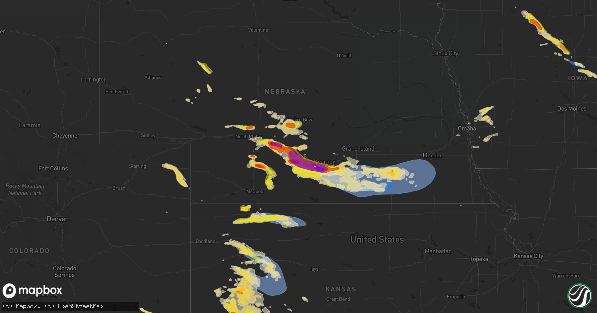
Hail Map on July 6, 2024
Get this storm
July 6 map
$229
one time, instant access
Download today. No call, no setup
Keep the $229
Bought the map and want the full workflow? Apply the entire $229 to a subscription within 7 days. None of it is wasted.
Every map, not just this one
This buys you this map. Subscription and you get every map we run, in the markets you choose from a few cities to whole states to nationwide. Plus real-time alerts the moment a storm fires.
Contact data
Name, contact info, occupancy, even credit band for addresses in the footprint. You go from where it hit to who to call.
Become the source they trust
Unlimited branding weather history reports on demand. You already have the documented answer ready for the property owner, and you are the one who showed up with it.
Property data and RoofTrace estimates
Pull up any address you have got, its value and the exact code rules for that jurisdiction, straight from One Click Code. Then RoofTrace estimates the squares, pitch, and roof value, priced the way you price.
States Impacted by Hail Map on July 6, 2024
Storm reports
Kansas
| Date | Description |
|---|---|
| 07/06/20246:55 PM CDT | A local report indicates 1.00 inch wind near Scott City |
| 07/06/20246:45 PM CDT | Mesonet station up856 0.8 e yocemento |
| 07/06/20245:09 PM CDT | Weather underground site kksutica3 reported a 64 mph gust. |
| 07/06/20245:09 PM CDT | A local report indicates 60 MPH wind near 15 SE Gove |
| 07/06/20245:04 PM CDT | Weather underground site kksutica3 reported a 60 mph wind gust. |
| 07/06/20245:00 PM CDT | Reported via social media. Numerous trees down on the property. All were healthy. Storm started around 3:30 with peak winds occurring around 4 pm. Location also receive |
| 07/06/20245:00 PM CDT | Corrects previous tstm wnd dmg report from 1 nne the monument rocks. Reported via social media. Numerous cottonwood... Elm... And cedar trees down on the property. All |
| 07/06/20244:36 PM CDT | A local report indicates 64 MPH wind near 10 S Quinter |
| 07/06/20244:35 PM CDT | Emergency manager reported a semi truck hauling a wind turbine blade was overturned due to straight line winds on hwy 83 near the smoky hill river bridge. Time is radar |
| 07/06/20244:33 PM CDT | Reported via ambient weather station my weather station. |
| 07/06/20244:20 PM CDT | Spotter estimated 70 mph gusts. Time is spotter and radar estimated. |
| 07/06/20244:01 PM CDT | Spotter estimated 60-70 mph winds ongoing. |
| 07/06/20243:50 PM CDT | A local report indicates 82 MPH wind near 6 NNW Gove |
| 07/06/20243:37 PM CDT | A local report indicates 65 MPH wind near 6 SSE Norton |
| 07/06/20243:26 PM CDT | A local report indicates 60 MPH wind near Campus |
| 07/06/20243:26 PM CDT | Report from mping: trees uprooted or snapped; roof blown off. Unsure of the exact degree of damage. |
| 07/06/20243:14 PM CDT | Reported via ambient weather station dog_house. |
| 07/06/20242:53 PM CDT | Delayed report. Two overturned semis reported near mile marker 64 on i-70 eastbound. Semis were empty. Most observations in the colby area measured around 50 mph when t |
| 07/06/20242:44 PM CDT | Reported via ambient weather station. |
| 07/06/20242:21 PM CDT | Spotter reported hail up to the size of quarters. Time estimated via radar. |
| 07/06/20242:10 PM CDT | Rawlins county dispatch has received reports of a tornado about 6 miles south of atwood. |
| 07/06/20242:07 PM CDT | Occurred at mm 75; then declined in size to nickel to dime. |
| 07/06/20241:53 PM CDT | Reported via social media. Occasional ping pong ball sized hail. Time estimated via radar. |
| 07/06/20241:40 PM CDT | Reported via social media. Dime to quarter sized hail fell for a duration of 10 minutes in herndon. Time radar estimated. |
| 07/06/20241:35 PM CDT | Public sent photos of 1-1.5 inch hail. Intersection of rds y/28 northeast of ludell. |
| 07/06/20242:05 AM CDT | Mesonet station gw3813 copeland. |
| 07/06/20241:03 AM CDT | A local report indicates 1.50 inch wind near 1 SSE Garden City |
| 07/06/20241:00 AM CDT | Report made via social media. |
| 07/06/20241:00 AM CDT | A local report indicates 1.25 inch wind near 1 SE Garden City |
| 07/05/202410:00 PM CDT | Mesonet station fw1214 la crosse. |
| 07/05/202410:00 PM CDT | Report made via social media. |
| 07/05/20249:45 PM CDT | Mesonet station fw1214 la crosse. |
| 07/05/20249:20 PM CDT | Asos station kgck garden city. |
| 07/05/20249:08 PM CDT | Asos station kgck garden city. |
| 07/05/20248:30 PM CDT | Mesonet station fw1214 la crosse. |
| 07/05/20248:24 PM CDT | Asos station kddc dodge city regional airport. |
| 07/05/20247:23 PM CDT | A local report indicates 1.50 inch wind near 1 SSW Scott City |
South Dakota
| Date | Description |
|---|---|
| 07/06/20245:48 PM CDT | Received a public report of quarter size. Time was estimated using radar. |
| 07/06/20245:48 PM CDT | Received a public |
| 07/06/20245:17 PM CDT | Nickel to quarter sized hail on highway 28 at the clark and hamlin county line. |
| 07/06/20245:17 PM CDT | Report from mping. 1-inch tree limbs broken. |
| 07/06/20244:50 PM CDT | A few tree branches down with pea sized hail. |
| 07/06/20244:45 PM CDT | Via facebook. |
| 07/06/20244:43 PM CDT | Via facebook. |
| 07/06/20244:15 PM CDT | Groton police reported quarter sized hail in town. |
| 07/06/20243:57 PM CDT | Numerous tree branches down in down. Leaves taken off trees due to the combination of the wind and 0.5 inch hail that covered the ground. |
| 07/06/20243:35 PM CDT | Awos station k1d8 redfield muni ap. |
| 07/06/20243:35 PM CDT | Tree branches and powerlines down in redfield. Quarter sized hail also reported. Via facebook. |
| 07/06/20243:20 PM CDT | Quarter sized hail and estimated 50 mph winds. Had some tree damage. Via facebook. |
| 07/06/20243:07 PM CDT | Dime to quarter sized hail at lake louise state park. |
| 07/06/20243:00 PM CDT | Via facebook. |
| 07/06/20242:48 PM CDT | Mesonet station 158 miranda |
| 07/06/20242:27 PM CDT | Hail of quarter to golf ball sized... Which produced crop damage. 1.5 inches of rain fell. |
North Carolina
| Date | Description |
|---|---|
| 07/06/20245:55 PM CDT | Tree down. |
| 07/06/20245:48 PM CDT | Power lines down. |
| 07/06/20245:45 PM CDT | Tree down. |
| 07/06/20245:23 PM CDT | Fallen trees resulting in power outages. |
| 07/06/20245:20 PM CDT | Tree down on mamie upchurch road. |
| 07/06/20245:12 PM CDT | Trees down and subsequent power outages. |
| 07/06/20245:02 PM CDT | Fallen trees causing power outage. |
| 07/06/20244:39 PM CDT | Tree snapped at intersection of crossway ln and flint point ln in holly springs. |
| 07/06/20244:00 PM CDT | Power outage sw of monroe attributed to fallen trees or limbs. Time estimated from radar. |
| 07/05/20247:37 PM CDT | Tree fell on a home on york spann rd... Punctured roof... And also pulled down power lines. Tree down near trivette rd near mullis rd. |
Minnesota
| Date | Description |
|---|---|
| 07/05/20248:02 PM CDT | Severe crop damage. |
| 07/05/20247:53 PM CDT | The murray county emergency manager reported quarter sized hail near hwy-30 in hadley. Time was estimated via radar. |
| 07/05/20247:47 PM CDT | A trained spotter reported pea to quarter size hail near lake wilson. Time was estimated via radar. |
| 07/05/20247:47 PM CDT | A trained spo |
| 07/05/20247:20 PM CDT | A trained spotter reported 2-3 inch branches down in downtown edgerton. Time was estimated using radar. |
| 07/05/20247:20 PM CDT | A trained spotter reported 2-3 inch branches down in downtown edgerton. T |
Wyoming
| Date | Description |
|---|---|
| 07/06/20245:44 PM CDT | A local report indicates 61 MPH wind near 6 SW Dwtn Gillette |
| 07/06/20245:23 PM CDT | A local report indicates 71 MPH wind near 1 NE Echeta |
| 07/06/20244:44 PM CDT | Asos station kbyg buffalo airport. |
| 07/06/20244:35 PM CDT | Time estimated from radar |
| 07/06/20243:55 PM CDT | Asos station kgey greybull airport. |
Georgia
| Date | Description |
|---|---|
| 07/06/20243:50 PM CDT | Tree fell down on multiple cars at columns at sweetwater apts. |
| 07/06/20243:50 PM CDT | Tree down at hazel street and fitzgerald st. |
| 07/06/20243:40 PM CDT | Tree down at s quail dr and bob white ln. |
| 07/06/20243:15 PM CDT | A large tree fell across manningtown rd. Photos were relayed social media. Time was estimated by radar. |
Nebraska
| Date | Description |
|---|---|
| 07/06/20246:33 PM CDT | Tree branches down 6-8 inches in diameter. |
| 07/06/20246:25 PM CDT | A local report indicates 60 MPH wind near 1 NW Western |
| 07/06/20245:57 PM CDT | A couple of very large trees blown down in alexandria. Report relayed from nws omaha via their facebook page. Time estimated from radar. |
| 07/06/20245:53 PM CDT | Report from mping: 1-inch tree limbs broken; shingles blown off. |
| 07/06/20245:45 PM CDT | A local report indicates 1.50 inch wind near 1 NE Geneva |
| 07/06/20245:41 PM CDT | A local report indicates 60 MPH wind near 5 W Geneva |
| 07/06/20245:36 PM CDT | A local report indicates 68 MPH wind near 3 WSW Carleton |
| 07/06/20245:36 PM CDT | A local report indicates 79 MPH wind near 2 SSE Davenport |
| 07/06/20245:35 PM CDT | A local report indicates 63 MPH wind near 4 ESE Davenport |
| 07/06/20245:32 PM CDT | A local report indicates 60 MPH wind near 3 SW Carleton |
| 07/06/20245:30 PM CDT | A local report indicates 72 MPH wind near Davenport |
| 07/06/20245:28 PM CDT | A local report indicates 62 MPH wind near 3 WNW Davenport |
| 07/06/20245:26 PM CDT | Distribution power line and poles down with pivots turned over between road 315 and 316. Time estimated based on radar. |
| 07/06/20245:25 PM CDT | A local report indicates 59 MPH wind near 5 W Davenport |
| 07/06/20245:24 PM CDT | A local report indicates 68 MPH wind near 4 SE Edgar |
| 07/06/20245:21 PM CDT | Report from mping: 1-inch tree limbs broken; shingles blown off. |
| 07/06/20245:20 PM CDT | A local report indicates 58 MPH wind near 1 NNW Edgar |
| 07/06/20245:19 PM CDT | A local report indicates 74 MPH wind near 3 S Edgar |
| 07/06/20245:18 PM CDT | A local report indicates 68 MPH wind near 2 SE Edgar |
| 07/06/20245:18 PM CDT | # miles nne of clay center em reports large trees down from storm. Time estimated from radar. |
| 07/06/20245:15 PM CDT | Corrects previous tstm wnd gst report from 4 nnw edgar. Weather station reported a 60 mph wind gust. |
| 07/06/20245:14 PM CDT | Corrects previous tstm wnd dmg report from 6 ese clay center. Tree branches down 6-8 inches in diameter. Time from radar. |
| 07/06/20245:14 PM CDT | Corrects previous tstm wnd gst report from 6 ese clay center. Estimated 60-70 mph winds with tree limb damage up to 8 inches in diameter. Dime sized hail around 530 pm. |
| 07/06/20245:09 PM CDT | Corrects previous tstm wnd gst report from 4 nnw edgar. |
| 07/06/20245:09 PM CDT | Weather station reported a 60 mph wind gust. |
| 07/06/20245:09 PM CDT | Estimated 60-70 mph winds with tree limb damage up to 8 inches in diameter. Dime sized hail around 530 pm. Time estimated from radar. |
| 07/06/20245:05 PM CDT | A local report indicates 71 MPH wind near 1 SE Clay Center |
| 07/06/20245:05 PM CDT | Tree damage and flooded streets in clay center. Time estimated based on radar. |
| 07/06/20245:04 PM CDT | A local report indicates 72 MPH wind near 3 WNW Clay Center |
| 07/06/20245:02 PM CDT | A local report indicates 61 MPH wind near 4 NNW Edgar |
| 07/06/20245:01 PM CDT | Weather station reported a 67 mph wind gust. |
| 07/06/20244:59 PM CDT | Power outage in hastings around south denver ave. |
| 07/06/20244:56 PM CDT | Video on x/twitter of tornado on ground 3 wsw of inland. |
| 07/06/20244:54 PM CDT | A local report indicates 78 MPH wind near 4 E Pauline |
| 07/06/20244:52 PM CDT | Storm chaser reported minor tree damage west of inland. Time estimated based on radar. |
| 07/06/20244:52 PM CDT | A local report indicates 62 MPH wind near 3 W Glenvil |
| 07/06/20244:52 PM CDT | Tree damage. |
| 07/06/20244:48 PM CDT | Report from mping: 1-inch tree limbs broken; shingles blown off. Time adjusted based on radar data. |
| 07/06/20244:48 PM CDT | Corrects previous tstm wnd dmg report from 2 s hastings. Report from mping: 1-inch tree limbs broken; shingles blown off. Time corrected based on radar data. |
| 07/06/20244:46 PM CDT | Lots of tree damage. Time estimated from radar. |
| 07/06/20244:45 PM CDT | Village clerk reported a collapsed roof and several trees uprooted. |
| 07/06/20244:40 PM CDT | A flag pole snapped in half with several branches 3-4 inches in diameter down. |
| 07/06/20244:38 PM CDT | Corrects previous tstm wnd gst report from 7 n inavale. Weather station reported a 67 mph wind gust. |
| 07/06/20244:36 PM CDT | A local report indicates 1.25 inch wind near Bladen |
| 07/06/20244:33 PM CDT | Weather station reported 67 mph wind gust. |
| 07/06/20244:30 PM CDT | Picture of damaged grain bin near roseland. Time estimated from radar and nearby weather stations. |
| 07/06/20244:28 PM CDT | Weather station reported a 64 mph wind gust. |
| 07/06/20244:28 PM CDT | A local report indicates 64 MPH wind near 2 ESE Campbell |
| 07/06/20244:26 PM CDT | 70 mph wind gust report relayed by emergency manager. |
| 07/06/20244:25 PM CDT | A photo of downed tree branches. Time estimated based on radar. |
| 07/06/20244:23 PM CDT | Khsi asos reported a 69mph wind gust. |
| 07/06/20244:23 PM CDT | Asos station khsi hastings airport. |
| 07/06/20244:20 PM CDT | A large tree split in half. |
| 07/06/20244:17 PM CDT | Report from mping: ping pong ball |
| 07/06/20244:16 PM CDT | A local report indicates 66 MPH wind near 2 E Juniata |
| 07/06/20244:06 PM CDT | A local report indicates 59 MPH wind near 7 ENE Huntley |
| 07/06/20244:05 PM CDT | Pivots down near norman. |
| 07/06/20244:00 PM CDT | Several branches down 4-6 inch diameter. A picture was sent through social media. |
| 07/06/20243:50 PM CDT | A spotter confirmed a tornado 1 mile north and east of minden. Report of tree damage. |
| 07/06/20243:50 PM CDT | Storm chaser with photo of a tornado between minden and heartwell. Location estimated based on radar. |
| 07/06/20243:45 PM CDT | Small shed flew into a cemetary. |
| 07/06/20243:45 PM CDT | Time estimated via radar and report. |
| 07/06/20243:44 PM CDT | A local report indicates 72 MPH wind near 4 WSW Minden |
| 07/06/20243:44 PM CDT | Personal weather station reported a 72mph wind gust. |
| 07/06/20243:37 PM CDT | Report from mping: golf ball |
| 07/06/20243:30 PM CDT | Ground partially white... Leaves off of trees. |
| 07/06/20243:10 PM CDT | Report from mping: ping pong ball |
| 07/06/20243:08 PM CDT | Weather station reported wind gust of 66mph. |
| 07/06/20243:08 PM CDT | A local report indicates 66 MPH wind near 5 NNW Holdrege |
| 07/06/20243:00 PM CDT | A local report indicates 1.75 inch wind near Curtis |
| 07/06/20242:48 PM CDT | Ground becoming covered with hail. Largest stones around quarter size. |
| 07/06/20242:45 PM CDT | Delayed report via social media. |
| 07/06/20242:45 PM CDT | Delayed report sent via social media. |
| 07/06/20242:40 PM CDT | Social media report with a photo. |
| 07/06/20242:35 PM CDT | A local report indicates 1.75 inch wind near 5 NE Wellfleet |
| 07/06/20242:26 PM CDT | A local report indicates 1.75 inch wind near 5 W Overton |
| 07/06/20242:20 PM CDT | Report from mping: golf ball |
| 07/06/20242:18 PM CDT | Report from mping: ping pong ball |
| 07/06/20242:11 PM CDT | Trained spotter reported baseball sized hail. Report relayed to holdrege pd. |
| 07/06/20242:07 PM CDT | Report from mping: half dollar |
| 07/06/20242:01 PM CDT | Social media report. |
| 07/06/20242:00 PM CDT | A local report indicates 62 MPH wind near 5 SSE Odessa |
| 07/06/20241:58 PM CDT | Report from mping: quarter |
| 07/06/20241:50 PM CDT | Social media image sent in. |
| 07/06/20241:48 PM CDT | Report from mping: golf ball |
| 07/06/20241:46 PM CDT | A local report indicates 1.00 inch wind near 9 S Elm Creek |
| 07/06/20241:45 PM CDT | A local report indicates 60 MPH wind near 6 E Callaway |
| 07/06/20241:44 PM CDT | A image sent in from social media. |
| 07/06/20241:37 PM CDT | Report relayed by emergency manager. |
| 07/06/20241:37 PM CDT | Time estimate based on radar... Report via social media. |
| 07/06/20241:37 PM CDT | Report from mping: half dollar |
| 07/06/20241:37 PM CDT | Corrects previous hail report from 4 s elm creek. Emergency manager reported quarter size to golf ball size hail near 747 and highway 183 south of elm creek. |
| 07/06/20241:23 PM CDT | Public reported tornado on the ground. Location estimated from radar. |
| 07/06/20241:08 PM CDT | A local report indicates 1.75 inch wind near 5 W Overton |
| 07/06/20241:00 PM CDT | Social media image sent in next to ruler. |
| 07/06/202412:58 PM CDT | A local report indicates 2.00 inch wind near 2 S Lexington |
| 07/06/202412:56 PM CDT | Report from mping: golf ball |
| 07/06/202412:55 PM CDT | Report from mping: hen egg |
| 07/06/202412:40 PM CDT | A local report indicates 1.75 inch wind near 7 NW Lexington |
| 07/06/202412:31 PM CDT | Report from mping: golf ball |
| 07/06/202412:26 PM CDT | Image of hail next to measuring tape sent in through social media. |
| 07/06/202412:18 PM CDT | Report from mping: half dollar |
| 07/06/202412:15 PM CDT | Social media photo of hail ranging in size from golf balls to two inches. |
| 07/06/202412:14 PM CDT | A local report indicates 1.75 inch wind near 1 N Gothenburg |
| 07/06/202412:14 PM CDT | A local report indicates 1.75 inch wind near 2 NNW Gothenburg |
| 07/06/202412:08 PM CDT | Approximate location of spotter. |
| 07/06/202411:59 AM CDT | Report from mping: golf ball |
| 07/06/202411:59 AM CDT | Via mping. |
| 07/06/202411:45 AM CDT | A local report indicates 1.25 inch wind near 3 W Brady |
| 07/06/202411:05 AM CDT | Via spotternetwork. |
| 07/05/20247:21 PM CDT | Report from mping: 1-inch tree limbs broken; shingles blown off. |
| 07/05/20247:20 PM CDT | Report called in measured from davis weather instrument. |
| 07/05/20247:20 PM CDT | Report from mping: 1-inch tree limbs broken; shingles blown off. |
| 07/05/20247:02 PM CDT | Report from mping: 1-inch tree limbs broken; shingles blown off. |
New York
| Date | Description |
|---|---|
| 07/06/20242:24 PM CDT | Downed tree in the town of amboy. |
Iowa
| Date | Description |
|---|---|
| 07/06/20246:47 PM CDT | Via who-tv. Time estimated from radar. |
| 07/06/20246:46 PM CDT | Report |
| 07/06/20246:46 PM CDT | Report via social media. |
| 07/06/20245:54 PM CDT | Healthy 6 inch diameter tree branches broken. |
| 07/06/20245:52 PM CDT | Power pole down just north of bode on 120th street. Time estimated from radar. |
| 07/06/20244:00 PM CDT | Shredded leaves with some dented cars. |
| 07/05/20249:28 PM CDT | Several tree limbs down with the biggest being 15 inch diameter. |
| 07/05/20249:27 PM CDT | Via mping. Time estimated from radar. |
| 07/05/20248:32 PM CDT | Corrects previous non-tstm wnd gst report from 4 ene ellsworth. Estimated winds of 50 to 60 mph and pea sized hail. |
| 07/05/20248:32 PM CDT | Corrects previous non-tstm wnd gst report from 4 ene ellsworth. Estimated winds of 50 to 60 mph and pea sized hail. Time estimated from radar. |
| 07/05/20247:11 PM CDT | A local report indicates 1.25 inch wind near 2 SE Woolstock |
North Dakota
| Date | Description |
|---|---|
| 07/06/20245:06 PM CDT | Tornado was on and off the ground for about 5 to 10 minutes as it traveled southeast. A farmstead was hit near the point of touchdown in which a camper was rolled over |
South Carolina
| Date | Description |
|---|---|
| 07/06/20244:38 PM CDT | Newberry county dispatch reported a tree down on sandy run creek road. No cross street given. Time estimated by radar. |
Texas
| Date | Description |
|---|---|
| 07/06/20246:41 PM CDT | Picture received from local law enforcement of approximately half dollar sized hail. Also reported accumulating hail up to one foot deep near fm 2161 and county road 7 |
| 07/06/20246:38 PM CDT | Pantex 4wsw mesonet measured peak gust of 59 mph with first severe gust observed at 634 pm. |
Cities Impacted by Hail Map on July 6, 2024
- Sutherland, NE
- Hershey, NE
- North Platte, NE
- Nome, ND
- Enderlin, ND
- Maxwell, NE
- Brady, NE
- Gothenburg, NE
- Buchanan, ND
- Stapleton, NE
- Willow Island, NE
- Cozad, NE
- Lexington, NE
- Arnold, NE
- Elwood, NE
- Westby, MT
- Brockton, MT
- Overton, NE
- Eddyville, NE
- Bertrand, NE
- Smithfield, NE
- Lidgerwood, ND
- Wyndmere, ND
- Merna, NE
- Anselmo, NE
- Lebanon, SD
- Broken Bow, NE
- Callaway, NE
- Eustis, NE
- Franklin, GA
- Roanoke, AL
- Elm Creek, NE
- Seneca, SD
- Sylacauga, AL
- Clanton, AL
- Tolstoy, SD
- Cohasset, MN
- Loomis, NE
- Holdrege, NE
- Pelion, SC
- Herndon, KS
- Ludell, KS
- Faulkton, SD
- Kearney, NE
- Funk, NE
- Brewster, KS
- Atwood, KS
- Angora, MN
- Britt, MN
- Carrollton, GA
- Onaka, SD
- Oberlin, KS
- Levant, KS
- Axtell, NE
- Marshville, NC
- Wellfleet, NE
- Houston, TX
- Cook, MN
- Sumner, NE
- Hayes Center, NE
- Orient, SD
- Maywood, NE
- Palmetto, GA
- Colby, KS
- Oconto, NE
- Granada, MN
- Truman, MN
- Sisseton, SD
- Minden, NE
- Douglasville, GA
- New Effington, SD
- Newnan, GA
- Winnebago, MN
- Selden, KS
- Highmore, SD
- Pearland, TX
- Heartwell, NE
- Albemarle, NC
- Ree Heights, SD
- Isabella, MN
- Oakley, KS
- Curtis, NE
- Rockham, SD
- Hockley, TX
- Fresno, TX
- Jennings, KS
- Holabird, SD
- Waller, TX
- Miller, SD
- Katy, TX
- Rugby, ND
- Hitchcock, SD
- Redfield, SD
- Rexford, KS
- Moorefield, NE
- Stockville, NE
- Norcatur, KS
- New London, NC
- Hoxie, KS
- Clayton, KS
- Norton, KS
- Farnam, NE
- Dumont, MN
- Poplar, MT
- Kenesaw, NE
- Dresden, KS
- Atlanta, NE
- Indianola, NE
- Bartley, NE
- Cambridge, NE
- Saint Lawrence, SD
- Grinnell, KS
- Kettle River, MN
- Lenora, KS
- Cotton, MN
- Makinen, MN
- Monument, KS
- Mason, TX
- Fredericksburg, TX
- Hildreth, NE
- Juniata, NE
- Grainfield, KS
- Wood River, NE
- Wilcox, NE
- Wheaton, MN
- Bethune, SC
- Winona, KS
- Llano, TX
- Holstein, NE
- Almena, KS
- Logan, KS
- Prairie View, KS
- Brimson, MN
- Silverstreet, SC
- Kinards, SC
- Gove, KS
- Park, KS
- Gibbon, NE
- Frankfort, SD
- Lyons, GA
- Hastings, NE
- Doniphan, NE
- Forsyth, GA
- Doland, SD
- Clinton, SC
- Juliette, GA
- Quinter, KS
- Eveleth, MN
- Groton, SD
- Upland, NE
- Castell, TX
- Jackson, GA
- Humboldt, IA
- Campbell, NE
- Andover, SD
- Iroquois, SD
- Roseland, NE
- Ortonville, MN
- Willow Lake, SD
- Livermore, IA
- Hardy, IA
- Riverton, NE
- Bladen, NE
- Saco, MT
- Ayr, NE
- Glenvil, NE
- Trumbull, NE
- Inland, NE
- Blue Hill, NE
- Red Cloud, NE
- Harvard, NE
- Guide Rock, NE
- Lawrence, NE
- Fairfield, NE
- Healy, KS
- Collyer, KS
- Raymond, SD
- Thor, IA
- Ruthven, IA
- Graettinger, IA
- Emmetsburg, IA
- Pierpont, SD
- Clinton, MN
- Apex, NC
- Holly Springs, NC
- Crescent, IA
- Clark, SD
- Goldfield, IA
- Superior, NE
- Nelson, NE
- Deweese, NE
- Clay Center, NE
- Edgar, NE
- Saronville, NE
- Oak, NE
- Utica, KS
- Dighton, KS
- Eagle Grove, IA
- Stanley, ND
- Cylinder, IA
- Raleigh, NC
- Cary, NC
- Underwood, IA
- Chokio, MN
- Fort Peck, MT
- Bryant, SD
- Erwin, SD
- Lake Norden, SD
- Lake Preston, SD
- Biwabik, MN
- Scott City, KS
- Whittemore, IA
- West Bend, IA
- Aurora, MN
- Kershaw, SC
- San Saba, TX
- New Hill, NC
- Blue Earth, MN
- Algona, IA
- Ottosen, IA
- Bode, IA
- Ruskin, NE
- Davenport, NE
- Shickley, NE
- Sutton, NE
- Ong, NE
- Hebron, NE
- Carleton, NE
- Deshler, NE
- Grafton, NE
- Strang, NE
- Geneva, NE
- Bruning, NE
- Fairmont, NE
- Neola, IA
- Wesson, MS
- Gilbert, MN
- Arlington, SD
- Rutland, IA
- Minden, IA
- Goldthwaite, TX
- East Dublin, GA
- Letcher, SD
- Beeler, KS
- Arnold, KS
- Ransom, KS
- Ness City, KS
- Badger, SD
- Belvidere, NE
- Ohiowa, NE
- Exeter, NE
- Milligan, NE
- Tobias, NE
- Alexandria, NE
- Fairbury, NE
- Gilead, NE
- Daykin, NE
- Mullin, TX
- Marienthal, KS
- Shelby, IA
- Persia, IA
- Panhandle, TX
- Robert Lee, TX
- Delavan, MN
- Amarillo, TX
- Milan, MN
- Avoca, IA
- Hancock, IA
- Harlan, IA
- Pleasanton, NE
- Talpa, TX
- Lometa, TX
- Lawn, TX
- Ovalo, TX
- Santa Anna, TX
- Papillion, NE
- Omaha, NE
- McDade, TX
- Friend, NE
- Jansen, NE
- Plymouth, NE
- Swanton, NE
- Western, NE
- Wilber, NE
- Crete, NE
- Milford, NE
- Dorchester, NE
- De Witt, NE
- Bruce, SD
- Volga, SD
- Benson, MN
- Appleton, MN
- Echo, MN
- Wood Lake, MN
- Danvers, MN
- Tuscola, TX
- Abilene, TX
- Montevideo, MN
- Ravenna, NE
- Coleman, TX
- Dakota City, IA
- Claude, TX
- Clarion, IA
- Merriman, NE
- Valera, TX
- Oakland, IA
- Vincent, IA
- Spring Hope, NC
- Nashville, NC
- Woolstock, IA
- Martell, NE
- Hallam, NE
- Beatrice, NE
- Denton, NE
- Firth, NE
- Pickrell, NE
- Cortland, NE
- Clatonia, NE
- Pleasant Dale, NE
- Adams, NE
- Roca, NE
- Hickman, NE
- Sprague, NE
- Granite Falls, MN
- Silver City, IA
- Malvern, IA
- Gillett, TX
- Haxtun, CO
- Pacific Junction, IA
- Webster City, IA
- Bazine, KS
- Cimarron, KS
- Brownwood, TX
- Clare, IA
- Hyannis, NE
- Castalia, NC
- Glenwood, IA
- Elkton, SD
- Raymond, MN
- Clara City, MN
- Hastings, IA
- Henderson, IA
- Paoli, CO
- Holyoke, CO
- Alexander, KS
- Stockdale, TX
- Tulare, SD
- Maynard, MN
- Jetmore, KS
- Groom, TX
- Wray, CO
- Jasper, MN
- Trent, SD
- Harmony, NC
- Olin, NC
- Badger, IA
- Edgerton, MN
- Chandler, MN
- Prinsburg, MN
- Blairsburg, IA
- Emerson, IA
- Burdett, KS
- Rozel, KS
- Canyon, TX
- Lake Wilson, MN
- Slayton, MN
- Duncombe, IA
- Macedonia, IA
- Griswold, IA
- Red Oak, IA
- Carson, IA
- Union Grove, NC
- Hamptonville, NC
- Jewell, IA
- Kamrar, IA
- Garden City, KS
- Frazer, MT
- Springfield, MN
- Wayside, TX
- Pipestone, MN
- Hanston, KS
- Kinsley, KS
- Fulda, MN
- Ellsworth, IA
- Comfrey, MN
- Wright, KS
- Dodge City, KS
- Spearville, KS
- Radcliffe, IA
- Westbrook, MN
- Walnut Grove, MN
- Storden, MN
- Hubbard, IA
- Seneca, KS
- Roland, IA
- Revere, MN
- Happy, TX
- Tulia, TX
- Ingalls, KS
- Pierceville, KS
- McCallsburg, IA
- Zearing, IA
- Saint Anthony, IA
- New Providence, IA
- Clemons, IA
- Ashby, NE
- Whitman, NE
- Montezuma, KS
- Copeland, KS
- Union, IA
- Marshalltown, IA
- Albion, IA
- Ensign, KS
- Meade, KS
- Fowler, KS
- Carter Lake, IA
- Plains, KS
- Tabor, IA
- Council Bluffs, IA
- Springfield, NE
- Leoti, KS
- Deerfield, KS
- Holcomb, KS
- Leesville, SC
- Salley, SC
- Englewood, KS
- Minneola, KS
- Hasty, CO
- Oshkosh, NE
- Lamar, CO
- Bricelyn, MN
- Las Animas, CO
- Syracuse, KS
- Holly, CO
- McClave, CO
- Sublette, KS
- Aline, OK
- Sharon, OK
- Rolla, KS
- Arnett, OK
- Vici, OK
- Manter, KS
- Hugoton, KS
- Leedey, OK
- Johnson, KS
- Taloga, OK
- Enid, OK
- Camargo, OK
- Seiling, OK
- Kingfisher, OK
- Hennessey, OK
- Ulysses, KS
- Dover, OK
- Fargo, OK
- Putnam, OK
- Satanta, KS
- Custer City, OK
- Woodward, OK
- Moscow, KS
- Mutual, OK
- Liberal, KS
- Parks, NE