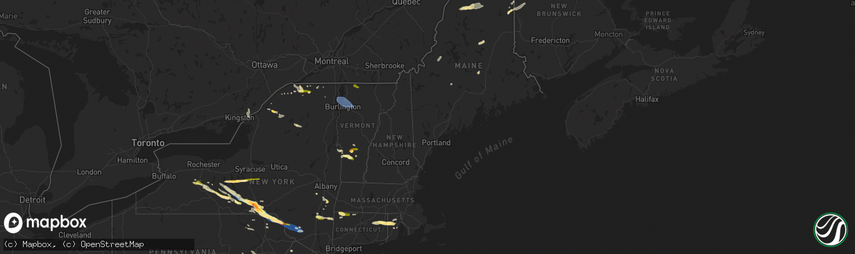
Hail Map in Maine on July 3, 2025
The weather event in Maine on July 3, 2025 includes Hail and Wind maps. 33 states and 930 cities were impacted and suffered possible damage. The total estimated number of properties impacted is 202.
Want more than just the map?
Turn this storm into a full workflow.
- Owner + property data so you know who to knock
- OnDemand branded weather history reports to win the "did we even have hail?" argument
- RoofTrace estimate so reps stop guessing numbers at the door
Bought this map? Upgrade within 7 days and we'll credit the $230. (10-15 min setup call)
Hail
Wind
202
Estimated number of impacted properties by a 1.00" hail or larger0
Estimated number of impacted properties by a 1.75" hail or larger0
Estimated number of impacted properties by a 2.50" hail or largerStorm reports in Maine
Maine
| Date | Description |
|---|---|
| 07/03/20252:48 PM CDT | Tree down on powerlines on water st. Time estimated by radar. |
| 07/03/20251:41 PM CDT | 911 caller reported a tree down in the howland area. Time estimated by radar. |
| 07/03/20251:00 PM CDT | 911 caller reported a tree down in east millinocket. Time estimated by radar. |
| 07/03/202512:43 PM CDT | Trees down on north stage coach rd in atkinson... Me. Time estimated by radar. |
| 07/03/202512:27 PM CDT | Tree across parsonsfield road in limerick. |
| 07/03/202512:27 PM CDT | Tree ac |
| 07/03/202512:13 PM CDT | Trees and powerlines down in the sangerville... Me area. Time estimated by radar. |
| 07/03/202511:50 AM CDT | Tree down blocking rt-302. Time estimated by radar. |
| 07/03/202511:40 AM CDT | Norway fire reported a large tree blown over onto powerlines on round the pond rd in norway. Time estimated by radar. |
| 07/03/202511:24 AM CDT | A tree was observed to be leaning on a powerline in the caribou area. Time estimated by radar. |
| 07/03/202511:20 AM CDT | Wires down. |
| 07/03/202510:53 AM CDT | 6-8 trees down across powerlines in the grand isle area. Time estimated by radar. |
| 07/03/202510:42 AM CDT | Multiple trees and powerlines down in the portage... Me area. Time estimated by radar. |
| 07/03/202510:42 AM CDT | Trees and powerlines down in the madawaska... Me area. Time estimated by radar. |
| 07/03/202510:38 AM CDT | Corrects previous hail report from 2 nnw westfield. Hail mostly nickel size... With a few up to half dollar size. |
| 07/03/202510:38 AM CDT | A local report indicates 1.00 inch wind near 2 S Easton |
All States Impacted by Hail Map on July 3, 2025
Cities Impacted by Hail Map on July 3, 2025
- Clayton Lake, ME
- Eagle Lake, ME
- Stockholm, ME
- Presque Isle, ME
- Westfield, ME
- Easton, ME
- Mars Hill, ME
- Sinclair, ME
- Lincoln, NH
- Fort Fairfield, ME
- Phillips, ME
- Bingham, ME
- Solon, ME
- Penn Yan, NY
- Athens, ME
- Wayland, NY
- Naples, NY
- Springwater, NY
- Branchport, NY
- Romulus, NY
- Prattsburgh, NY
- Geneva, NY
- Cohocton, NY
- Atlanta, NY
- Dundee, NY
- Himrod, NY
- Keuka Park, NY
- Hammondsport, NY
- Rock Stream, NY
- Ovid, NY
- Aurora, NY
- Scipio Center, NY
- Union Springs, NY
- Leicester, NY
- Piffard, NY
- Conesus, NY
- Mount Morris, NY
- Lodi, NY
- Scottsburg, NY
- Geneseo, NY
- Groveland, NY
- Dansville, NY
- Moravia, NY
- Bradford, NY
- Watkins Glen, NY
- Hector, NY
- Trumansburg, NY
- Interlaken, NY
- Homer, NY
- Skaneateles, NY
- Milo, ME
- Canandaigua, NY
- Honeoye, NY
- Odessa, NY
- Burdett, NY
- Middlesex, NY
- Ithaca, NY
- Preble, NY
- Tully, NY
- Montour Falls, NY
- Alpine, NY
- Newfield, NY
- La Fayette, NY
- Apulia Station, NY
- Van Etten, NY
- Cayuta, NY
- Spencer, NY
- Fabius, NY
- Truxton, NY
- Willseyville, NY
- Brooktondale, NY
- Candor, NY
- Berkshire, NY
- De Ruyter, NY
- New Woodstock, NY
- Newark Valley, NY
- Millport, NY
- Lisle, NY
- Jackman, ME
- Maine, NY
- Monroe, LA
- Auburn, PA
- Orwigsburg, PA
- Endicott, NY
- Johnson City, NY
- Glen Aubrey, NY
- Binghamton, NY
- Castle Creek, NY
- Livonia, NY
- Horseheads, NY
- El Dorado, AR
- Jackson, NH
- Intervale, NH
- Glen, NH
- Whitney Point, NY
- Conklin, NY
- Kirkwood, NY
- Windsor, NY
- Port Crane, NY
- Harpursville, NY
- Vestal, NY
- Chenango Forks, NY
- Susquehanna, PA
- Harrisonburg, LA
- Jonesville, LA
- Gouverneur, NY
- Richville, NY
- Great Bend, PA
- Hallstead, PA
- Wyalusing, PA
- Madrid, NY
- Thompson, PA
- Starrucca, PA
- New Milford, PA
- Lakewood, PA
- Pleasant Mount, PA
- Greenville, NY
- Dewey, AZ
- Newton, NJ
- Westerlo, NY
- Wapwallopen, PA
- Laceyville, PA
- Sugarloaf, PA
- Nescopeck, PA
- Bloomsburg, PA
- Mifflinville, PA
- Berwick, PA
- Preston Park, PA
- Sugar Run, PA
- Union Dale, PA
- Lake Como, PA
- Jackson, PA
- Starlight, PA
- Equinunk, PA
- Norfolk, NY
- Greene, NY
- Hop Bottom, PA
- Massena, NY
- South Gibson, PA
- Lenoxville, PA
- West Pawlet, VT
- Drums, PA
- Meshoppen, PA
- Mountain Top, PA
- Damascus, PA
- Apalachin, NY
- Callicoon, NY
- Hortonville, NY
- Winthrop, NY
- Norwood, NY
- Bombay, NY
- Hogansburg, NY
- Forest City, PA
- Hazleton, PA
- Pawlet, VT
- Brasher Falls, NY
- Danby, VT
- Sheppton, PA
- Cottonwood, AZ
- Helena, NY
- Portland, MI
- Eagle, MI
- Grand Ledge, MI
- Rock Glen, PA
- Zion Grove, PA
- Conyngham, PA
- Ringtown, PA
- West Coxsackie, NY
- Jeffersonville, NY
- Kenoza Lake, NY
- Swan Lake, NY
- Long Lake, NY
- Whitehall, NY
- Granville, NY
- Wells, VT
- Humboldt, AZ
- Moira, NY
- East Canaan, CT
- Southfield, MA
- Sheffield, MA
- Salisbury, CT
- Canaan, CT
- Ashley Falls, MA
- Saugerties, NY
- Lake Katrine, NY
- Ruby, NY
- Kingston, NY
- Mcadoo, PA
- Fort Covington, NY
- Athens, NY
- Coxsackie, NY
- Hudson, NY
- Stuyvesant, NY
- Hurley, NY
- Ghent, NY
- Monticello, NY
- Rozet, WY
- Constable, NY
- Malone, NY
- Glen Wild, NY
- Mountain Dale, NY
- South Fallsburg, NY
- Woodridge, NY
- East Dorset, VT
- Hampton, NY
- Middle Granville, NY
- Dorset, VT
- Norfolk, CT
- Mershon, GA
- Bristol, GA
- Falls Village, CT
- Stottville, NY
- Charlotte, MI
- Cornville, AZ
- Poultney, VT
- North Granville, NY
- Tucson, AZ
- Brushton, NY
- North Bangor, NY
- Tresckow, PA
- Winsted, CT
- Colebrook, CT
- Ulster Park, NY
- Port Ewen, NY
- Rhinebeck, NY
- Barkhamsted, CT
- Riverton, CT
- West Hartland, CT
- Staatsburg, NY
- De Peyster, NY
- Heuvelton, NY
- Hammond, NY
- Montrose, PA
- Clayton, NY
- Live Oak, FL
- West Granby, CT
- North Granby, CT
- East Hartland, CT
- Wurtsboro, NY
- Rock Hill, NY
- Rimrock, AZ
- Hermon, NY
- Dickinson Center, NY
- Kiamesha Lake, NY
- Jal, NM
- Harrisville, NY
- Lehighton, PA
- Germansville, PA
- Burke, NY
- Moorcroft, WY
- Beaver Meadows, PA
- Junedale, PA
- Weatherly, PA
- Brackney, PA
- Germantown, NY
- Elizaville, NY
- Wallingford, VT
- East Wallingford, VT
- Churubusco, NY
- Chateaugay, NY
- Slatington, PA
- Andreas, PA
- Kingman, AZ
- Edwards, NY
- Russell, NY
- Jim Thorpe, PA
- Granby, CT
- Londonderry, VT
- Peru, VT
- Saranac, NY
- Amenia, NY
- Oswegatchie, NY
- Fine, NY
- Coplay, PA
- Schnecksville, PA
- Slatedale, PA
- Millerton, NY
- Stanfordville, NY
- Baton Rouge, LA
- Natchez, MS
- Pine Plains, NY
- West Cornwall, CT
- Goshen, CT
- Ellenburg Depot, NY
- North Clarendon, VT
- Cuttingsville, VT
- Helena, OK
- Robinson, IL
- Cedar Vale, KS
- Hermitage, MO
- Philo, OH
- Oxford, OH
- Jamestown, OH
- Fleetwood, PA
- Patoka, IL
- Arnold, MO
- O'Fallon, IL
- Saint Clair, MO
- Shirleysburg, PA
- Roseville, OH
- Blain, PA
- Ashville, OH
- Stockton, MO
- Camdenton, MO
- New Concord, OH
- Windber, PA
- East Carondelet, IL
- Saint Louis, MO
- Cumberland, OH
- Crocker, MO
- Montreal, MO
- Scottdale, PA
- Zanesville, OH
- Duncan, AZ
- Bloomington, IN
- Catawissa, MO
- Macungie, PA
- Columbus, IN
- Belle Vernon, PA
- Macks Creek, MO
- Farina, IL
- Cuba, MO
- Willcox, AZ
- Boswell, PA
- Saint Paul, KS
- Quaker City, OH
- Ingraham, IL
- Mohrsville, PA
- Bentleyville, PA
- South Plainfield, NJ
- Upper Black Eddy, PA
- Waynesville, OH
- Imperial, MO
- Todd, PA
- Louisville, IL
- Jeffersonville, OH
- Roaring Spring, PA
- Trenton, IL
- Fort Sumner, NM
- Bound Brook, NJ
- Jacobsburg, OH
- Summerfield, IL
- Charleroi, PA
- Chandlersville, OH
- Merom, IN
- Flemington, MO
- Union, MO
- Pleasantville, OH
- Dunlevy, PA
- Lebanon, IL
- Aline, OK
- Carroll, OH
- Belleville, IL
- Cleo Springs, OK
- Ruffs Dale, PA
- Imler, PA
- Worthington, IN
- Canal Winchester, OH
- Mount Sterling, OH
- Oblong, IL
- Tunas, MO
- Elliottsburg, PA
- Alum Bank, PA
- Piscataway, NJ
- Flemington, NJ
- Magdalena, NM
- Nashville, IN
- Girard, KS
- Stahlstown, PA
- Barnesville, OH
- Linn Creek, MO
- Jonestown, PA
- Sheldon, MO
- Buckhorn, NM
- Orient, OH
- Bethesda, OH
- Emmaus, PA
- Fenton, MO
- Mount Pleasant, PA
- Mertztown, PA
- Richland, MO
- Spring Valley, OH
- Mooreland, OK
- Sedan, KS
- Solsberry, IN
- Cassville, PA
- Senecaville, OH
- House Springs, MO
- High Ridge, MO
- Rehrersburg, PA
- Brookville, IN
- Hope, IN
- Coopersburg, PA
- Nineveh, IN
- Ponca City, OK
- Pittsburg, MO
- Bridgewater, NJ
- Shermans Dale, PA
- Sullivan, IN
- Urbana, MO
- Sharon, OK
- Belle, MO
- Dayton, OH
- Loysville, PA
- Sullivan, MO
- Bellaire, OH
- Scenery Hill, PA
- Palestine, IL
- Hamilton, OH
- Independence, KS
- Belmont, OH
- Breese, IL
- Franklin, OH
- Springboro, OH
- Blackwell, OK
- Thornville, OH
- Prosperity, PA
- Newkirk, OK
- Acme, PA
- Orbisonia, PA
- Trenton, OH
- Dauphin, PA
- Jerome, PA
- Xenia, OH
- Millstadt, IL
- Somerset, OH
- Dennis, KS
- Lancaster, OH
- Martinsburg, PA
- James Creek, PA
- Dixon, MO
- Valley Grove, WV
- Frenchtown, NJ
- Cherryvale, KS
- Bernville, PA
- Rector, PA
- Coal Center, PA
- Middletown, OH
- Iberia, MO
- Myerstown, PA
- Mapleton Depot, PA
- Newton, IL
- Colonia, NJ
- Canadian, TX
- Humansville, MO
- Benwood, WV
- Vega, TX
- Miami, TX
- Greensburg, IN
- Claysville, PA
- Fredericksburg, PA
- Robertsville, MO
- Smithton, PA
- Washington, PA
- Bland, MO
- Landisburg, PA
- Lamar, MO
- Pleasant City, OH
- McCune, KS
- Medford, OK
- Linton, IN
- Rushville, OH
- Bloomfield, IN
- Metamora, IN
- Vienna, MO
- Willow Hill, IL
- Arnett, OK
- New Bloomfield, PA
- Queen, PA
- Dupo, IL
- Amity, PA
- Mount Perry, OH
- Grantville, PA
- Wheeling, WV
- Parsons, KS
- Goltry, OK
- Shoemakersville, PA
- Polk, MO
- Spencer, IN
- Cliff, NM
- Dugger, IN
- Ligonier, PA
- Hollsopple, PA
- Blue Rock, OH
- Jerico Springs, MO
- Carlyle, IL
- Middlesex, NJ
- Perryopolis, PA
- Pond Creek, OK
- Pittsburg, KS
- Somerville, NJ
- Corona, NM
- Rosebud, MO
- Silver City, NM
- Duncannon, PA
- Mulberry, KS
- Benson, AZ
- Owensville, MO
- Triadelphia, WV
- Ottsville, PA
- Kinmundy, IL
- Duncan Falls, OH
- Aviston, IL
- Plymouth, VT
- Mount Holly, VT
- Great Barrington, MA
- Northampton, PA
- Whitehall, PA
- Cherryville, PA
- Laurys Station, PA
- Walnutport, PA
- Basking Ridge, NJ
- Weston, VT
- Allentown, PA
- Bethlehem, PA
- Sharon, CT
- Hampton, IA
- Easton, PA
- Belvidere, NJ
- Phillipsburg, NJ
- Oxford, NJ
- Port Murray, NJ
- Great Meadows, NJ
- Budd Lake, NJ
- Hackettstown, NJ
- Long Valley, NJ
- Flanders, NJ
- Washington, NJ
- Stewartsville, NJ
- Hampton, NJ
- Glen Gardner, NJ
- Clinton, NJ
- Asbury, NJ
- Bloomsbury, NJ
- Califon, NJ
- Pittstown, NJ
- Mendham, NJ
- Gladstone, NJ
- Bernardsville, NJ
- Martinsville, NJ
- Peapack, NJ
- High Bridge, NJ
- Oldwick, NJ
- Morristown, NJ
- Far Hills, NJ
- Warren, NJ
- Bedminster, NJ
- Millington, NJ
- Chester, NJ
- Randolph, NJ
- Succasunna, NJ
- Annandale, NJ
- Whitehouse Station, NJ
- Lebanon, NJ
- Lake Huntington, NY
- Cochecton, NY
- Bethel, NY
- White Lake, NY
- Harris, NY
- Smallwood, NY
- Ferndale, NY
- Mongaup Valley, NY
- Forestburgh, NY
- Mansfield Center, CT
- Storrs Mansfield, CT
- Watchung, NJ
- Plainfield, NJ
- Dunellen, NJ
- Tamaqua, PA
- Bath, PA
- Rockford, IA
- Palmerton, PA
- Summit Hill, PA
- Nazareth, PA
- Parkersburg, IA
- Hampton, CT
- Chaplin, CT
- Pomfret Center, CT
- Brooklyn, CT
- Charles City, IA
- Woodbridge, NJ
- Sewaren, NJ
- Port Reading, NJ
- Iselin, NJ
- Edison, NJ
- Scotch Plains, NJ
- Avenel, NJ
- Grand Isle, VT
- South Hero, VT
- Underhill, VT
- Essex Junction, VT
- Milton, VT
- Jericho, VT
- Westford, VT
- Colchester, VT
- Winooski, VT
- South Burlington, VT
- Burlington, VT
- Williston, VT
- Dayville, CT
- Danielson, CT
- Foster, RI
- Sterling, CT
- Moosup, CT
- North Windham, CT
- Staten Island, NY
- Williams, AZ
- New Hartford, IA
- Cedar Falls, IA
- Hellertown, PA
- Clinton Corners, NY
- Clayville, RI
- Cassville, WI
- Catasauqua, PA
- Carteret, NJ
- Montague, CA
- Yreka, CA
- Traer, IA
- Gladbrook, IA
- Epworth, IA
- Peosta, IA
- North Scituate, RI
- Hope, RI
- Cranston, RI
- Greenville, RI
- Smithfield, RI
- Johnston, RI
- Conrad, IA
- Coventry, RI
- West Greenwich, RI
- Barnesville, PA
- Nesquehoning, PA
- East Greenwich, RI
- Warwick, RI
- Bernard, IA
- Perth Amboy, NJ
- Enosburg Falls, VT
- East Berkshire, VT
- Richford, VT
- Providence, RI
- West Warwick, RI
- East Providence, RI
- Riverside, RI
- Barrington, RI
- Seekonk, MA
- Rehoboth, MA
- Swansea, MA
- Warren, RI
- Calverton, NY
- Manorville, NY
- Laurel, NY
- South Jamesport, NY
- Mattituck, NY
- Riverhead, NY
- Jamesport, NY
- Hampton Bays, NY
- East Quogue, NY
- Westhampton Beach, NY
- Mcarthur, CA
- Waterloo, IA
- Beaman, IA
- Grundy Center, IA
- Prairie Du Chien, WI
- North Kingstown, RI
- North Providence, RI
- Dike, IA
- Reinbeck, IA
- Morrison, IA
- Hudson, IA
- Garnavillo, IA
- Elkader, IA
- Bagley, WI
- Cascade, IA
- Dysart, IA
- Lookout, CA
- Westport, MA
- North Dartmouth, MA
- Prudence Island, RI
- Fall River, MA
- Dunkerton, IA
- Winslow, AZ
- Camp Crook, SD
- Buffalo, SD
- Fairbank, IA
- Heber, AZ
- Assonet, MA
- Somerset, MA
- Forest Hill, LA
- Woodman, WI
- Mount Hope, WI
- Dighton, MA
- East Freetown, MA
- New Bedford, MA
- Acushnet, MA
- Rochester, MA
- Lakeville, MA
- West Wareham, MA
- Marion, MA
- Wareham, MA
- Mattapoisett, MA
- Maricopa, AZ
- Jesup, IA
- Steuben, WI
- McGregor, IA
- East Wareham, MA
- Plymouth, MA
- Buzzards Bay, MA
- Independence, IA
- Sagamore Beach, MA
- Arlington, IA
- Fayette, IA
- Carver, MA
- Volga, IA
- Winthrop, IA
- Aurora, IA
- Dorris, CA
- Macdoel, CA
- Sundance, WY
- Ashland, OR
- Decorah, IA
- Coolidge, AZ
- Casa Grande, AZ
- Monticello, IA
- Mandaree, ND
- Lamont, IA
- Masonville, IA
- Sentinel Butte, ND
- Medora, ND
- Woodstock, CT
- North Grosvenordale, CT
- Manchester, IA
- Eastford, CT
- Dundee, IA
- Greene, RI
- Chepachet, RI
- Waukon, IA
- Voluntown, CT
- Jewett City, CT
- Canterbury, CT
- Plainfield, CT
- Delaware, IA
- Delhi, IA
- Hopkinton, IA
- Rhame, ND
- Keno, OR
- New Town, ND
- Dairy, OR
- Earlville, IA
- Belfield, ND
- Sprague River, OR
- Bonanza, OR
- Chiloquin, OR
- South Heart, ND
- Bartlett, NH
- Wheeler, WI
- Boyceville, WI
- Dickinson, ND
- Chisago City, MN
- Wyoming, MN
- Forest Lake, MN
- New Richmond, WI
- Quakake, PA
- Delano, PA
- Lansford, PA
- Coaldale, PA
- Colfax, WI
- Baldwin, WI
- Hammond, WI
- Scandia, MN
- Eau Claire, WI
- Glenwood City, WI
- Woodville, WI
- Lindstrom, MN
- Center City, MN
- Shafer, MN
- Gladstone, ND
- Osceola, WI
- Hixton, WI
- Alma Center, WI
- Deer Park, WI
- Osseo, WI
- Menomonie, WI
- Elk Mound, WI
- Greeley, IA
- Coventry, CT
- Knapp, WI
- Fairchild, WI
- Stanley, WI
- Boyd, WI
- North Branch, MN
- Ludlow, SD
- Arkdale, WI
- Augusta, WI
- Dallas, WI
- Prairie Farm, WI
- Willard, WI
- Fall Creek, WI
- Downing, WI
- Taylors Falls, MN
- Neillsville, WI
- Strum, WI
- Black River Falls, WI
- Nekoosa, WI
- Bowman, ND
- Scranton, ND
- Grantsburg, WI
- Luck, WI
- Greenwood, WI
- Wilson, WI
- Mondovi, WI
- Hornbrook, CA
- Saint Croix Falls, WI
- Taylor, WI
- Star Prairie, WI
- Langdon, ND
- Frederic, WI
- Cushing, WI
- Alsen, ND
- Osnabrock, ND
- New England, ND
- Wales, ND
- Centuria, WI
- Amidon, ND
- Hannah, ND
- Killdeer, ND
- Watford City, ND
- Keene, ND
- Sarles, ND
- Milltown, WI
- Walhalla, ND
- Granton, WI
- Chili, WI
- Spencer, WI
- Loyal, WI
- Eau Galle, WI
- Parshall, ND
- Roseglen, ND
- Eleva, WI
- Hamilton, ND
- Clear Lake, WI
- Ridgeland, WI
- Rolla, ND
- Pembina, ND
- Siren, WI
- Bathgate, ND
- Bruce, WI
- Ladysmith, WI
- Exeland, WI
- Independence, WI
- Bloomer, WI
- Whitehall, WI
- Arcadia, WI
- Webster, WI
- Chippewa Falls, WI
- Palermo, ND
- Berthold, ND
- Plaza, ND
- Makoti, ND
- Minot, ND
- Des Lacs, ND
- Burlington, ND
- Ryder, ND
- Douglas, ND
- Beulah, ND
- Zap, ND
- Golden Valley, ND
- Carpio, ND
- Calvin, ND
- Sandstone, MN
- Sedona, AZ
- Munich, ND
- Jim Falls, WI
- Mohall, ND
- Lansford, ND
- Glenburn, ND
- Bangor, WI
- West Salem, WI
- Washburn, ND
- Stanton, ND
- Cadott, WI
- Danbury, WI
- La Crosse, WI
- Granville, ND
- Bottineau, ND
- Spooner, WI
- Kramer, ND
- Souris, ND
- Salem, WI
- Foxboro, WI
- Shell Lake, WI
- Trego, WI
- Dunseith, ND
- Willow City, ND
- Hunt, TX
- Cumberland, WI
- Rolette, ND
- Gordon, WI
- Barronett, WI
- Sarona, WI
- Superior, WI
- Muscoda, WI
- South Range, WI
- Solon Springs, WI
- Brimson, MN
- Two Harbors, MN
- Orr, MN
- Burlington, WI
- New Providence, NJ
- Linden, NJ
- Stirling, NJ
- Summit, NJ
- Green Village, NJ
- Berkeley Heights, NJ
- Cranford, NJ
- Rahway, NJ
- New Vernon, NJ
- Fanwood, NJ
- Mountainside, NJ
- Clark, NJ
- Chatham, NJ
- Garwood, NJ
- Gillette, NJ
- Westfield, NJ
- Fords, NJ
- Metuchen, NJ
- Keasbey, NJ
- Roselle, NJ
- Springfield, NJ
- Roselle Park, NJ
- Kenilworth, NJ


