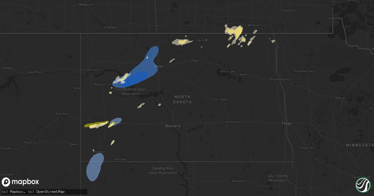
Hail Map in North Dakota on July 3, 2025
Get this storm
July 3 map
$229
one time, instant access
Download today. No call, no setup
Keep the $229
Bought the map and want the full workflow? Apply the entire $229 to a subscription within 7 days. None of it is wasted.
Every map, not just this one
This buys you this map. Subscription and you get every map we run, in the markets you choose from a few cities to whole states to nationwide. Plus real-time alerts the moment a storm fires.
Contact data
Name, contact info, occupancy, even credit band for addresses in the footprint. You go from where it hit to who to call.
Become the source they trust
Unlimited branding weather history reports on demand. You already have the documented answer ready for the property owner, and you are the one who showed up with it.
Property data and RoofTrace estimates
Pull up any address you have got, its value and the exact code rules for that jurisdiction, straight from One Click Code. Then RoofTrace estimates the squares, pitch, and roof value, priced the way you price.
Storm reports in North Dakota
North Dakota
| Date | Description |
|---|---|
| 07/03/20252:50 AM CDT | Tree blown over in overnight thunderstorm. Time estimated from radar. |
| 07/03/20252:50 AM CDT | Tree blown over in overni |
| 07/03/20252:20 AM CDT | Edinburg... Nd-32 nd dot rwis station. |
| 07/03/20251:00 AM CDT | Private weather station southeast of parshall. |
| 07/03/20251:00 AM CDT | Private weather station southeast of parshall. ( |
| 07/03/202512:56 AM CDT | Asos station kdik dickinson airport. |
| 07/03/202512:33 AM CDT | Asos station kdik dickinson airport. |
| 07/03/202512:30 AM CDT | Camper was blown over. No other details on damage at this time. |
| 07/03/202512:30 AM CDT | Social media report and photo of a very heavy animal lean building... That was anchored to the ground... Destroyed. Also reports this structure was picked up and thrown |
| 07/03/202512:24 AM CDT | 10 m gust at ndawn station 5 wsw parshall. |
| 07/03/202512:20 AM CDT | Estimated 70-90 mph winds |
| 07/03/202512:19 AM CDT | 10 m gust at ndawn station 5 wsw parshall. |
| 07/02/20259:45 PM CDT | 10 meter wind gust from ndawn station. |
| 07/02/20259:15 PM CDT | Social media video of heavy rain and hail estimated up to the size of a quarter. |
All States Impacted by Hail Map on July 3, 2025
Cities Impacted by Hail Map on July 3, 2025
- Clayton Lake, ME
- Eagle Lake, ME
- Stockholm, ME
- Presque Isle, ME
- Westfield, ME
- Easton, ME
- Mars Hill, ME
- Sinclair, ME
- Lincoln, NH
- Fort Fairfield, ME
- Phillips, ME
- Bingham, ME
- Solon, ME
- Penn Yan, NY
- Athens, ME
- Wayland, NY
- Naples, NY
- Springwater, NY
- Branchport, NY
- Romulus, NY
- Prattsburgh, NY
- Geneva, NY
- Cohocton, NY
- Atlanta, NY
- Dundee, NY
- Himrod, NY
- Keuka Park, NY
- Hammondsport, NY
- Rock Stream, NY
- Ovid, NY
- Aurora, NY
- Scipio Center, NY
- Union Springs, NY
- Leicester, NY
- Piffard, NY
- Conesus, NY
- Mount Morris, NY
- Lodi, NY
- Scottsburg, NY
- Geneseo, NY
- Groveland, NY
- Dansville, NY
- Moravia, NY
- Bradford, NY
- Watkins Glen, NY
- Hector, NY
- Trumansburg, NY
- Interlaken, NY
- Homer, NY
- Skaneateles, NY
- Milo, ME
- Canandaigua, NY
- Honeoye, NY
- Odessa, NY
- Burdett, NY
- Middlesex, NY
- Ithaca, NY
- Preble, NY
- Tully, NY
- Montour Falls, NY
- Alpine, NY
- Newfield, NY
- La Fayette, NY
- Apulia Station, NY
- Van Etten, NY
- Cayuta, NY
- Spencer, NY
- Fabius, NY
- Truxton, NY
- Willseyville, NY
- Brooktondale, NY
- Candor, NY
- Berkshire, NY
- De Ruyter, NY
- New Woodstock, NY
- Newark Valley, NY
- Millport, NY
- Lisle, NY
- Jackman, ME
- Maine, NY
- Monroe, LA
- Auburn, PA
- Orwigsburg, PA
- Endicott, NY
- Johnson City, NY
- Glen Aubrey, NY
- Binghamton, NY
- Castle Creek, NY
- Livonia, NY
- Horseheads, NY
- El Dorado, AR
- Jackson, NH
- Intervale, NH
- Glen, NH
- Whitney Point, NY
- Conklin, NY
- Kirkwood, NY
- Windsor, NY
- Port Crane, NY
- Harpursville, NY
- Vestal, NY
- Chenango Forks, NY
- Susquehanna, PA
- Harrisonburg, LA
- Jonesville, LA
- Gouverneur, NY
- Richville, NY
- Great Bend, PA
- Hallstead, PA
- Wyalusing, PA
- Madrid, NY
- Thompson, PA
- Starrucca, PA
- New Milford, PA
- Lakewood, PA
- Pleasant Mount, PA
- Greenville, NY
- Dewey, AZ
- Newton, NJ
- Westerlo, NY
- Wapwallopen, PA
- Laceyville, PA
- Sugarloaf, PA
- Nescopeck, PA
- Bloomsburg, PA
- Mifflinville, PA
- Berwick, PA
- Preston Park, PA
- Sugar Run, PA
- Union Dale, PA
- Lake Como, PA
- Jackson, PA
- Starlight, PA
- Equinunk, PA
- Norfolk, NY
- Greene, NY
- Hop Bottom, PA
- Massena, NY
- South Gibson, PA
- Lenoxville, PA
- West Pawlet, VT
- Drums, PA
- Meshoppen, PA
- Mountain Top, PA
- Damascus, PA
- Apalachin, NY
- Callicoon, NY
- Hortonville, NY
- Winthrop, NY
- Norwood, NY
- Bombay, NY
- Hogansburg, NY
- Forest City, PA
- Hazleton, PA
- Pawlet, VT
- Brasher Falls, NY
- Danby, VT
- Sheppton, PA
- Cottonwood, AZ
- Helena, NY
- Portland, MI
- Eagle, MI
- Grand Ledge, MI
- Rock Glen, PA
- Zion Grove, PA
- Conyngham, PA
- Ringtown, PA
- West Coxsackie, NY
- Jeffersonville, NY
- Kenoza Lake, NY
- Swan Lake, NY
- Long Lake, NY
- Whitehall, NY
- Granville, NY
- Wells, VT
- Humboldt, AZ
- Moira, NY
- East Canaan, CT
- Southfield, MA
- Sheffield, MA
- Salisbury, CT
- Canaan, CT
- Ashley Falls, MA
- Saugerties, NY
- Lake Katrine, NY
- Ruby, NY
- Kingston, NY
- Mcadoo, PA
- Fort Covington, NY
- Athens, NY
- Coxsackie, NY
- Hudson, NY
- Stuyvesant, NY
- Hurley, NY
- Ghent, NY
- Monticello, NY
- Rozet, WY
- Constable, NY
- Malone, NY
- Glen Wild, NY
- Mountain Dale, NY
- South Fallsburg, NY
- Woodridge, NY
- East Dorset, VT
- Hampton, NY
- Middle Granville, NY
- Dorset, VT
- Norfolk, CT
- Mershon, GA
- Bristol, GA
- Falls Village, CT
- Stottville, NY
- Charlotte, MI
- Cornville, AZ
- Poultney, VT
- North Granville, NY
- Tucson, AZ
- Brushton, NY
- North Bangor, NY
- Tresckow, PA
- Winsted, CT
- Colebrook, CT
- Ulster Park, NY
- Port Ewen, NY
- Rhinebeck, NY
- Barkhamsted, CT
- Riverton, CT
- West Hartland, CT
- Staatsburg, NY
- De Peyster, NY
- Heuvelton, NY
- Hammond, NY
- Montrose, PA
- Clayton, NY
- Live Oak, FL
- West Granby, CT
- North Granby, CT
- East Hartland, CT
- Wurtsboro, NY
- Rock Hill, NY
- Rimrock, AZ
- Hermon, NY
- Dickinson Center, NY
- Kiamesha Lake, NY
- Jal, NM
- Harrisville, NY
- Lehighton, PA
- Germansville, PA
- Burke, NY
- Moorcroft, WY
- Beaver Meadows, PA
- Junedale, PA
- Weatherly, PA
- Brackney, PA
- Germantown, NY
- Elizaville, NY
- Wallingford, VT
- East Wallingford, VT
- Churubusco, NY
- Chateaugay, NY
- Slatington, PA
- Andreas, PA
- Kingman, AZ
- Edwards, NY
- Russell, NY
- Jim Thorpe, PA
- Granby, CT
- Londonderry, VT
- Peru, VT
- Saranac, NY
- Amenia, NY
- Oswegatchie, NY
- Fine, NY
- Coplay, PA
- Schnecksville, PA
- Slatedale, PA
- Millerton, NY
- Stanfordville, NY
- Baton Rouge, LA
- Natchez, MS
- Pine Plains, NY
- West Cornwall, CT
- Goshen, CT
- Ellenburg Depot, NY
- North Clarendon, VT
- Cuttingsville, VT
- Helena, OK
- Robinson, IL
- Cedar Vale, KS
- Hermitage, MO
- Philo, OH
- Oxford, OH
- Jamestown, OH
- Fleetwood, PA
- Patoka, IL
- Arnold, MO
- O'Fallon, IL
- Saint Clair, MO
- Shirleysburg, PA
- Roseville, OH
- Blain, PA
- Ashville, OH
- Stockton, MO
- Camdenton, MO
- New Concord, OH
- Windber, PA
- East Carondelet, IL
- Saint Louis, MO
- Cumberland, OH
- Crocker, MO
- Montreal, MO
- Scottdale, PA
- Zanesville, OH
- Duncan, AZ
- Bloomington, IN
- Catawissa, MO
- Macungie, PA
- Columbus, IN
- Belle Vernon, PA
- Macks Creek, MO
- Farina, IL
- Cuba, MO
- Willcox, AZ
- Boswell, PA
- Saint Paul, KS
- Quaker City, OH
- Ingraham, IL
- Mohrsville, PA
- Bentleyville, PA
- South Plainfield, NJ
- Upper Black Eddy, PA
- Waynesville, OH
- Imperial, MO
- Todd, PA
- Louisville, IL
- Jeffersonville, OH
- Roaring Spring, PA
- Trenton, IL
- Fort Sumner, NM
- Bound Brook, NJ
- Jacobsburg, OH
- Summerfield, IL
- Charleroi, PA
- Chandlersville, OH
- Merom, IN
- Flemington, MO
- Union, MO
- Pleasantville, OH
- Dunlevy, PA
- Lebanon, IL
- Aline, OK
- Carroll, OH
- Belleville, IL
- Cleo Springs, OK
- Ruffs Dale, PA
- Imler, PA
- Worthington, IN
- Canal Winchester, OH
- Mount Sterling, OH
- Oblong, IL
- Tunas, MO
- Elliottsburg, PA
- Alum Bank, PA
- Piscataway, NJ
- Flemington, NJ
- Magdalena, NM
- Nashville, IN
- Girard, KS
- Stahlstown, PA
- Barnesville, OH
- Linn Creek, MO
- Jonestown, PA
- Sheldon, MO
- Buckhorn, NM
- Orient, OH
- Bethesda, OH
- Emmaus, PA
- Fenton, MO
- Mount Pleasant, PA
- Mertztown, PA
- Richland, MO
- Spring Valley, OH
- Mooreland, OK
- Sedan, KS
- Solsberry, IN
- Cassville, PA
- Senecaville, OH
- House Springs, MO
- High Ridge, MO
- Rehrersburg, PA
- Brookville, IN
- Hope, IN
- Coopersburg, PA
- Nineveh, IN
- Ponca City, OK
- Pittsburg, MO
- Bridgewater, NJ
- Shermans Dale, PA
- Sullivan, IN
- Urbana, MO
- Sharon, OK
- Belle, MO
- Dayton, OH
- Loysville, PA
- Sullivan, MO
- Bellaire, OH
- Scenery Hill, PA
- Palestine, IL
- Hamilton, OH
- Independence, KS
- Belmont, OH
- Breese, IL
- Franklin, OH
- Springboro, OH
- Blackwell, OK
- Thornville, OH
- Prosperity, PA
- Newkirk, OK
- Acme, PA
- Orbisonia, PA
- Trenton, OH
- Dauphin, PA
- Jerome, PA
- Xenia, OH
- Millstadt, IL
- Somerset, OH
- Dennis, KS
- Lancaster, OH
- Martinsburg, PA
- James Creek, PA
- Dixon, MO
- Valley Grove, WV
- Frenchtown, NJ
- Cherryvale, KS
- Bernville, PA
- Rector, PA
- Coal Center, PA
- Middletown, OH
- Iberia, MO
- Myerstown, PA
- Mapleton Depot, PA
- Newton, IL
- Colonia, NJ
- Canadian, TX
- Humansville, MO
- Benwood, WV
- Vega, TX
- Miami, TX
- Greensburg, IN
- Claysville, PA
- Fredericksburg, PA
- Robertsville, MO
- Smithton, PA
- Washington, PA
- Bland, MO
- Landisburg, PA
- Lamar, MO
- Pleasant City, OH
- McCune, KS
- Medford, OK
- Linton, IN
- Rushville, OH
- Bloomfield, IN
- Metamora, IN
- Vienna, MO
- Willow Hill, IL
- Arnett, OK
- New Bloomfield, PA
- Queen, PA
- Dupo, IL
- Amity, PA
- Mount Perry, OH
- Grantville, PA
- Wheeling, WV
- Parsons, KS
- Goltry, OK
- Shoemakersville, PA
- Polk, MO
- Spencer, IN
- Cliff, NM
- Dugger, IN
- Ligonier, PA
- Hollsopple, PA
- Blue Rock, OH
- Jerico Springs, MO
- Carlyle, IL
- Middlesex, NJ
- Perryopolis, PA
- Pond Creek, OK
- Pittsburg, KS
- Somerville, NJ
- Corona, NM
- Rosebud, MO
- Silver City, NM
- Duncannon, PA
- Mulberry, KS
- Benson, AZ
- Owensville, MO
- Triadelphia, WV
- Ottsville, PA
- Kinmundy, IL
- Duncan Falls, OH
- Aviston, IL
- Plymouth, VT
- Mount Holly, VT
- Great Barrington, MA
- Northampton, PA
- Whitehall, PA
- Cherryville, PA
- Laurys Station, PA
- Walnutport, PA
- Basking Ridge, NJ
- Weston, VT
- Allentown, PA
- Bethlehem, PA
- Sharon, CT
- Hampton, IA
- Easton, PA
- Belvidere, NJ
- Phillipsburg, NJ
- Oxford, NJ
- Port Murray, NJ
- Great Meadows, NJ
- Budd Lake, NJ
- Hackettstown, NJ
- Long Valley, NJ
- Flanders, NJ
- Washington, NJ
- Stewartsville, NJ
- Hampton, NJ
- Glen Gardner, NJ
- Clinton, NJ
- Asbury, NJ
- Bloomsbury, NJ
- Califon, NJ
- Pittstown, NJ
- Mendham, NJ
- Gladstone, NJ
- Bernardsville, NJ
- Martinsville, NJ
- Peapack, NJ
- High Bridge, NJ
- Oldwick, NJ
- Morristown, NJ
- Far Hills, NJ
- Warren, NJ
- Bedminster, NJ
- Millington, NJ
- Chester, NJ
- Randolph, NJ
- Succasunna, NJ
- Annandale, NJ
- Whitehouse Station, NJ
- Lebanon, NJ
- Lake Huntington, NY
- Cochecton, NY
- Bethel, NY
- White Lake, NY
- Harris, NY
- Smallwood, NY
- Ferndale, NY
- Mongaup Valley, NY
- Forestburgh, NY
- Mansfield Center, CT
- Storrs Mansfield, CT
- Watchung, NJ
- Plainfield, NJ
- Dunellen, NJ
- Tamaqua, PA
- Bath, PA
- Rockford, IA
- Palmerton, PA
- Summit Hill, PA
- Nazareth, PA
- Parkersburg, IA
- Hampton, CT
- Chaplin, CT
- Pomfret Center, CT
- Brooklyn, CT
- Charles City, IA
- Woodbridge, NJ
- Sewaren, NJ
- Port Reading, NJ
- Iselin, NJ
- Edison, NJ
- Scotch Plains, NJ
- Avenel, NJ
- Grand Isle, VT
- South Hero, VT
- Underhill, VT
- Essex Junction, VT
- Milton, VT
- Jericho, VT
- Westford, VT
- Colchester, VT
- Winooski, VT
- South Burlington, VT
- Burlington, VT
- Williston, VT
- Dayville, CT
- Danielson, CT
- Foster, RI
- Sterling, CT
- Moosup, CT
- North Windham, CT
- Staten Island, NY
- Williams, AZ
- New Hartford, IA
- Cedar Falls, IA
- Hellertown, PA
- Clinton Corners, NY
- Clayville, RI
- Cassville, WI
- Catasauqua, PA
- Carteret, NJ
- Montague, CA
- Yreka, CA
- Traer, IA
- Gladbrook, IA
- Epworth, IA
- Peosta, IA
- North Scituate, RI
- Hope, RI
- Cranston, RI
- Greenville, RI
- Smithfield, RI
- Johnston, RI
- Conrad, IA
- Coventry, RI
- West Greenwich, RI
- Barnesville, PA
- Nesquehoning, PA
- East Greenwich, RI
- Warwick, RI
- Bernard, IA
- Perth Amboy, NJ
- Enosburg Falls, VT
- East Berkshire, VT
- Richford, VT
- Providence, RI
- West Warwick, RI
- East Providence, RI
- Riverside, RI
- Barrington, RI
- Seekonk, MA
- Rehoboth, MA
- Swansea, MA
- Warren, RI
- Calverton, NY
- Manorville, NY
- Laurel, NY
- South Jamesport, NY
- Mattituck, NY
- Riverhead, NY
- Jamesport, NY
- Hampton Bays, NY
- East Quogue, NY
- Westhampton Beach, NY
- Mcarthur, CA
- Waterloo, IA
- Beaman, IA
- Grundy Center, IA
- Prairie Du Chien, WI
- North Kingstown, RI
- North Providence, RI
- Dike, IA
- Reinbeck, IA
- Morrison, IA
- Hudson, IA
- Garnavillo, IA
- Elkader, IA
- Bagley, WI
- Cascade, IA
- Dysart, IA
- Lookout, CA
- Westport, MA
- North Dartmouth, MA
- Prudence Island, RI
- Fall River, MA
- Dunkerton, IA
- Winslow, AZ
- Camp Crook, SD
- Buffalo, SD
- Fairbank, IA
- Heber, AZ
- Assonet, MA
- Somerset, MA
- Forest Hill, LA
- Woodman, WI
- Mount Hope, WI
- Dighton, MA
- East Freetown, MA
- New Bedford, MA
- Acushnet, MA
- Rochester, MA
- Lakeville, MA
- West Wareham, MA
- Marion, MA
- Wareham, MA
- Mattapoisett, MA
- Maricopa, AZ
- Jesup, IA
- Steuben, WI
- McGregor, IA
- East Wareham, MA
- Plymouth, MA
- Buzzards Bay, MA
- Independence, IA
- Sagamore Beach, MA
- Arlington, IA
- Fayette, IA
- Carver, MA
- Volga, IA
- Winthrop, IA
- Aurora, IA
- Dorris, CA
- Macdoel, CA
- Sundance, WY
- Ashland, OR
- Decorah, IA
- Coolidge, AZ
- Casa Grande, AZ
- Monticello, IA
- Mandaree, ND
- Lamont, IA
- Masonville, IA
- Sentinel Butte, ND
- Medora, ND
- Woodstock, CT
- North Grosvenordale, CT
- Manchester, IA
- Eastford, CT
- Dundee, IA
- Greene, RI
- Chepachet, RI
- Waukon, IA
- Voluntown, CT
- Jewett City, CT
- Canterbury, CT
- Plainfield, CT
- Delaware, IA
- Delhi, IA
- Hopkinton, IA
- Rhame, ND
- Keno, OR
- New Town, ND
- Dairy, OR
- Earlville, IA
- Belfield, ND
- Sprague River, OR
- Bonanza, OR
- Chiloquin, OR
- South Heart, ND
- Bartlett, NH
- Wheeler, WI
- Boyceville, WI
- Dickinson, ND
- Chisago City, MN
- Wyoming, MN
- Forest Lake, MN
- New Richmond, WI
- Quakake, PA
- Delano, PA
- Lansford, PA
- Coaldale, PA
- Colfax, WI
- Baldwin, WI
- Hammond, WI
- Scandia, MN
- Eau Claire, WI
- Glenwood City, WI
- Woodville, WI
- Lindstrom, MN
- Center City, MN
- Shafer, MN
- Gladstone, ND
- Osceola, WI
- Hixton, WI
- Alma Center, WI
- Deer Park, WI
- Osseo, WI
- Menomonie, WI
- Elk Mound, WI
- Greeley, IA
- Coventry, CT
- Knapp, WI
- Fairchild, WI
- Stanley, WI
- Boyd, WI
- North Branch, MN
- Ludlow, SD
- Arkdale, WI
- Augusta, WI
- Dallas, WI
- Prairie Farm, WI
- Willard, WI
- Fall Creek, WI
- Downing, WI
- Taylors Falls, MN
- Neillsville, WI
- Strum, WI
- Black River Falls, WI
- Nekoosa, WI
- Bowman, ND
- Scranton, ND
- Grantsburg, WI
- Luck, WI
- Greenwood, WI
- Wilson, WI
- Mondovi, WI
- Hornbrook, CA
- Saint Croix Falls, WI
- Taylor, WI
- Star Prairie, WI
- Langdon, ND
- Frederic, WI
- Cushing, WI
- Alsen, ND
- Osnabrock, ND
- New England, ND
- Wales, ND
- Centuria, WI
- Amidon, ND
- Hannah, ND
- Killdeer, ND
- Watford City, ND
- Keene, ND
- Sarles, ND
- Milltown, WI
- Walhalla, ND
- Granton, WI
- Chili, WI
- Spencer, WI
- Loyal, WI
- Eau Galle, WI
- Parshall, ND
- Roseglen, ND
- Eleva, WI
- Hamilton, ND
- Clear Lake, WI
- Ridgeland, WI
- Rolla, ND
- Pembina, ND
- Siren, WI
- Bathgate, ND
- Bruce, WI
- Ladysmith, WI
- Exeland, WI
- Independence, WI
- Bloomer, WI
- Whitehall, WI
- Arcadia, WI
- Webster, WI
- Chippewa Falls, WI
- Palermo, ND
- Berthold, ND
- Plaza, ND
- Makoti, ND
- Minot, ND
- Des Lacs, ND
- Burlington, ND
- Ryder, ND
- Douglas, ND
- Beulah, ND
- Zap, ND
- Golden Valley, ND
- Carpio, ND
- Calvin, ND
- Sandstone, MN
- Sedona, AZ
- Munich, ND
- Jim Falls, WI
- Mohall, ND
- Lansford, ND
- Glenburn, ND
- Bangor, WI
- West Salem, WI
- Washburn, ND
- Stanton, ND
- Cadott, WI
- Danbury, WI
- La Crosse, WI
- Granville, ND
- Bottineau, ND
- Spooner, WI
- Kramer, ND
- Souris, ND
- Salem, WI
- Foxboro, WI
- Shell Lake, WI
- Trego, WI
- Dunseith, ND
- Willow City, ND
- Hunt, TX
- Cumberland, WI
- Rolette, ND
- Gordon, WI
- Barronett, WI
- Sarona, WI
- Superior, WI
- Muscoda, WI
- South Range, WI
- Solon Springs, WI
- Brimson, MN
- Two Harbors, MN
- Orr, MN
- Burlington, WI
- New Providence, NJ
- Linden, NJ
- Stirling, NJ
- Summit, NJ
- Green Village, NJ
- Berkeley Heights, NJ
- Cranford, NJ
- Rahway, NJ
- New Vernon, NJ
- Fanwood, NJ
- Mountainside, NJ
- Clark, NJ
- Chatham, NJ
- Garwood, NJ
- Gillette, NJ
- Westfield, NJ
- Fords, NJ
- Metuchen, NJ
- Keasbey, NJ
- Roselle, NJ
- Springfield, NJ
- Roselle Park, NJ
- Kenilworth, NJ


