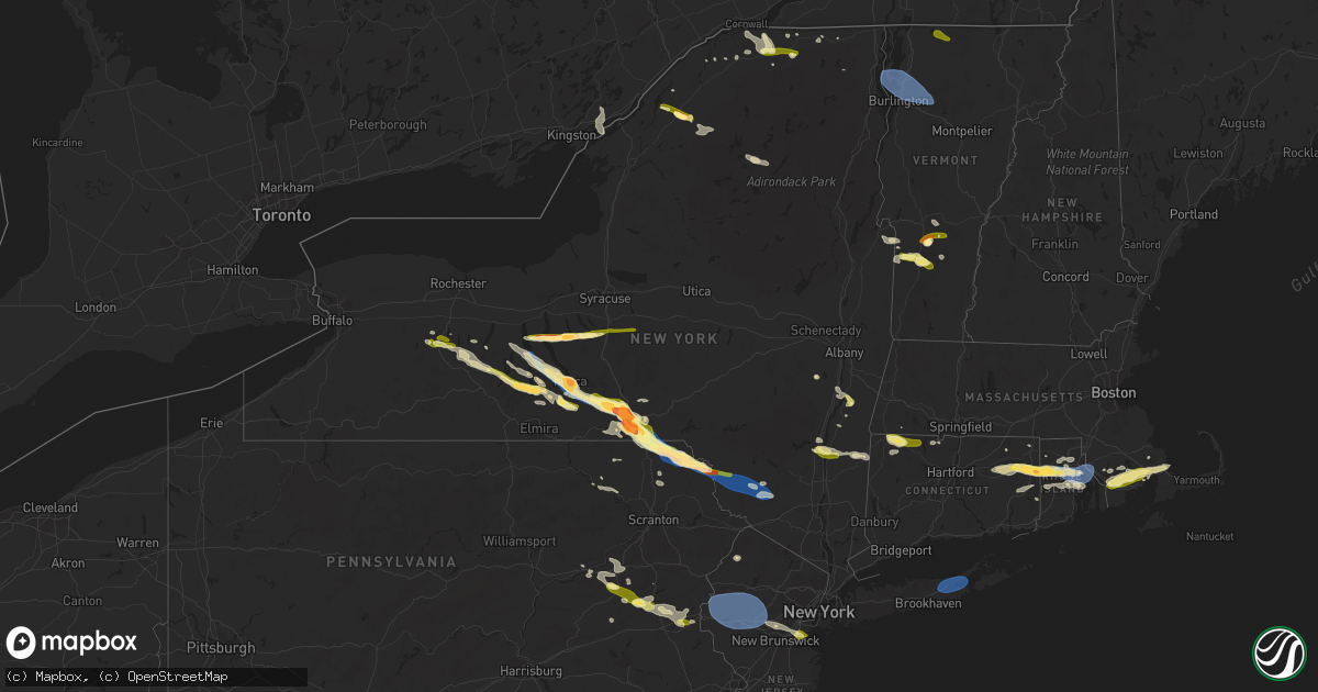
Hail Map in New York on July 3, 2025
Get this storm
July 3 map
$229
one time, instant access
Download today. No call, no setup
Keep the $229
Bought the map and want the full workflow? Apply the entire $229 to a subscription within 7 days. None of it is wasted.
Every map, not just this one
This buys you this map. Subscription and you get every map we run, in the markets you choose from a few cities to whole states to nationwide. Plus real-time alerts the moment a storm fires.
Contact data
Name, contact info, occupancy, even credit band for addresses in the footprint. You go from where it hit to who to call.
Become the source they trust
Unlimited branding weather history reports on demand. You already have the documented answer ready for the property owner, and you are the one who showed up with it.
Property data and RoofTrace estimates
Pull up any address you have got, its value and the exact code rules for that jurisdiction, straight from One Click Code. Then RoofTrace estimates the squares, pitch, and roof value, priced the way you price.
Storm reports in New York
New York
| Date | Description |
|---|---|
| 07/03/20256:13 PM CDT | Photo shared by nyc emergency management of quarter sized hail in hugu |
| 07/03/20256:13 PM CDT | Photo shared by nyc emergency management of quarter sized hail in huguenot. |
| 07/03/20256:10 PM CDT | A local report indicates 60 MPH wind near 1 NE Calverton |
| 07/03/20255:35 PM CDT | Large tree down on christopher lane near croton place. |
| 07/03/20255:28 PM CDT | Corrects previous hail report from huguenot. Photo shared by nyc emergency management of quarter sized hail in huguenot. Time estimated from radar. |
| 07/03/20255:25 PM CDT | Large tree down on cromer street. |
| 07/03/20255:25 PM CDT | Corrects previous tstm wnd dmg report from 1 wsw westerleigh. Large tree down on christopher lane near croton place. |
| 07/03/20255:25 PM CDT | A local report indicates 0 MPH wind near 1 NNE Annadale |
| 07/03/20255:20 PM CDT | Large tree down on rae avenue. |
| 07/03/20255:09 PM CDT | Ny dot reports tree down on ny 100 at saw mill river road. All lanes closed. Time estimated from radar. |
| 07/03/20255:00 PM CDT | Tree down and blocking lanes on taconic state parkway near rossway road. |
| 07/03/20255:00 PM CDT | Multiple reports of trees and wires down in plattburgh and beekmantown. |
| 07/03/20254:55 PM CDT | Tree down on wires. Old castle point road is impassable. |
| 07/03/20254:54 PM CDT | Tree and wires down on mahoney road. |
| 07/03/20254:50 PM CDT | Wires on house. |
| 07/03/20254:50 PM CDT | Trees and wires down on military turnpike. |
| 07/03/20254:46 PM CDT | Tree and wires down on herman drive. |
| 07/03/20254:46 PM CDT | Wires down. |
| 07/03/20254:45 PM CDT | Tree downed in lagrange. |
| 07/03/20254:43 PM CDT | Tree on wires. |
| 07/03/20254:43 PM CDT | Corrects previous tstm wnd dmg report from 1 nne chester. Tree on wires. |
| 07/03/20254:37 PM CDT | Tree and wires down. |
| 07/03/20254:37 PM CDT | Corrects previous tstm wnd dmg report from 1 s goshen. Tree and wires down. |
| 07/03/20254:35 PM CDT | Wires downed on route 32. |
| 07/03/20254:30 PM CDT | Tree and wires downed on horsenden road. |
| 07/03/20254:24 PM CDT | Tree down on taconic state parkway northbound north of pumpkin lane. |
| 07/03/20254:23 PM CDT | Social media report of multiple large trees down on rte 82 in stanfordville. |
| 07/03/20254:20 PM CDT | Tree and wires down and on fire on arnott lane at goshen turnpike. |
| 07/03/20254:18 PM CDT | Broken pole and downed tension wires on highway 209 as per disptach feed. Radar-estimated time. |
| 07/03/20254:13 PM CDT | Tree down on over highway 209... As per dispatch feed. Radar-estimated time. |
| 07/03/20254:12 PM CDT | Two trees downed on a driveway. |
| 07/03/20254:12 PM CDT | Tree downed on ny route 9g at ny 308 in rhinebeck. Two lanes blocked. |
| 07/03/20254:10 PM CDT | Trees and wires down near mill road and brockway road. |
| 07/03/20254:09 PM CDT | Tree down on browns pond road near lake pleasant road in the town of clinton. |
| 07/03/20254:08 PM CDT | Tree downed and blocking traffic on us route 9 southbound between mill road and ackert hook road. |
| 07/03/20254:07 PM CDT | Trees downed on albany post road. |
| 07/03/20254:03 PM CDT | Trees downed in esopus. |
| 07/03/20254:00 PM CDT | Wires downed on minturn street. |
| 07/03/20254:00 PM CDT | Quarter size hail reported in the village of rhinebeck. |
| 07/03/20254:00 PM CDT | Quarter size hail reported in the village of rhinebeck. |
| 07/03/20253:58 PM CDT | Trees down on gallop... Perry... And taylor roads in the town of bangor. |
| 07/03/20253:56 PM CDT | Social media report of quarter size hail. Time estimated from radar. |
| 07/03/20253:55 PM CDT | Tree down and downed wires and road closure on us 9w both directions north of ulster avenue. |
| 07/03/20253:55 PM CDT | Multiple trees down near the intersection of state route 11 and state route 11b. |
| 07/03/20253:55 PM CDT | Trees and wires down in a couple locations... Including cold spring road as per dispatch feed. Radar-estimated time. |
| 07/03/20253:54 PM CDT | Trees and wires down on elk drive... As per dispatch feed. Radar-estimated time. |
| 07/03/20253:52 PM CDT | Trees and wires down on katrine lane. |
| 07/03/20253:50 PM CDT | Hail did damage to plants and garden. |
| 07/03/20253:50 PM CDT | Trees and wires down near lucas avenue at heritage drive. |
| 07/03/20253:49 PM CDT | A local report indicates 1.00 inch wind near 2 ENE Stottville |
| 07/03/20253:48 PM CDT | Shed blown into old monticello road as per dispatch feed. Radar-estimated time. |
| 07/03/20253:43 PM CDT | Social media report of a tree down near route 28 near beesmer road in kingston. |
| 07/03/20253:40 PM CDT | Multiple downed trees. Segar road as per dispatch feed. Radar-estimated time. |
| 07/03/20253:40 PM CDT | Quarter size hail in moria... Ny. |
| 07/03/20253:27 PM CDT | Half to silver dollar sized hail |
| 07/03/20253:20 PM CDT | Tree down on propane tank... As per dispatch feed. Hortonville area. Radar-estimated time. |
| 07/03/20253:18 PM CDT | Tree down on roadway... Near hilltop road... As per dispatch feed. Radar-estimated time. |
| 07/03/20253:12 PM CDT | Tree down onto powerlines on haggerty road in potsdam. |
| 07/03/20252:33 PM CDT | Numerous trees and wires down throughout broome county and the greater binghamton area. |
| 07/03/20252:27 PM CDT | Half to silver dollar sized hail |
| 07/03/20252:12 PM CDT | Tree down on conklin-kirkwood bridge. Pic sent to nws binghamton via social media. Radar-estimated time. |
| 07/03/20252:10 PM CDT | Pair of trees uprooted onto vehicle at a conklin road property... Heavily damaging it. Also lifted tow trailer. Pic sent to nws binghamton via social media. Radar-estim |
| 07/03/20252:04 PM CDT | Multiple trees down via social media photo in kirkwood ny. |
| 07/03/20252:04 PM CDT | Corrects previous tstm wnd dmg report from 1 n conklin. Multiple trees down via social media photo in kirkwood ny. |
| 07/03/20252:03 PM CDT | Burst of pea sized hail with scattered quarter sized pieces. |
| 07/03/20252:03 PM CDT | Size estimated from photo. |
| 07/03/20252:03 PM CDT | Estimated half dollar hail via social media photo. |
| 07/03/20252:00 PM CDT | Estimated half dollar hail via social media photo. |
| 07/03/20252:00 PM CDT | Corrects previous tstm wnd dmg report from port dickinson. Numerous trees and wires down throughout broome county and the greater binghamton area. |
| 07/03/20252:00 PM CDT | A local report indicates 1.50 inch wind near Chenango Bridge |
| 07/03/20252:00 PM CDT | Large trees snapped and uprooted. Photo shared with nws of the tree damage. |
| 07/03/20252:00 PM CDT | Estimated hail size from photo. |
| 07/03/20251:59 PM CDT | Elongated hail... Size estimated from photo. |
| 07/03/20251:59 PM CDT | Tree down over south apple gate road. |
| 07/03/20251:59 PM CDT | Tree down over trumansburg road. |
| 07/03/20251:59 PM CDT | Nickel to quarter size hail in burdett. |
| 07/03/20251:58 PM CDT | Property damage reported. |
| 07/03/20251:58 PM CDT | Trees snapped... Property damage reported... 1 inch hail estimate. |
| 07/03/20251:58 PM CDT | Multiple trees fallen on property on roosevelt avenue... Via social media photo. |
| 07/03/20251:56 PM CDT | A local report indicates 1.25 inch wind near 1 E Johnson City |
| 07/03/20251:55 PM CDT | Numerous trees down over upper front street. |
| 07/03/20251:55 PM CDT | Estimated 2 inch hail from social media photo. |
| 07/03/20251:55 PM CDT | Estimated hail on glen avenue. |
| 07/03/20251:55 PM CDT | Trees on wires on bradley creek road. |
| 07/03/20251:55 PM CDT | Tree down over glen avenue... Property damage reported. |
| 07/03/20251:52 PM CDT | Multiple uprooted trees... Downed power lines... And estimated 1 inch hail size. |
| 07/03/20251:50 PM CDT | Multiple photos of estimated golf ball size hail... Shown with a quarter coin via social media photo. |
| 07/03/20251:50 PM CDT | Portion of roof peeled off horse barn near airport. Picture sent to nws binghamton via social media. Radar-estimated time. |
| 07/03/20251:48 PM CDT | A local report indicates 1.75 inch wind near NWS Binghamton |
| 07/03/20251:47 PM CDT | Wires down over airport road. |
| 07/03/20251:47 PM CDT | Large pine trees down by power hill road. |
| 07/03/20251:45 PM CDT | Estimated golf ball size hail via social media photo. |
| 07/03/20251:45 PM CDT | Updates previous hail report from maine. Estimated golf ball size hail via social media photo. Also wind-driven hail damage to siding of house on state route 26. |
| 07/03/20251:45 PM CDT | Large snapped trees along hardy road. |
| 07/03/20251:45 PM CDT | Estimated ping pong hail via social media photo. |
| 07/03/20251:43 PM CDT | At least 10 trees down behind house on east maine road. Radar-estimated time. Photo sent to nws binghamton via social media. |
| 07/03/20251:40 PM CDT | Multiple uprooted trees along pollard hill road... Facing south-southwest. |
| 07/03/20251:35 PM CDT | 61 mph max wind gust reported at the berkshire nys mesonet. |
| 07/03/20251:05 PM CDT | Numerous trees and wires down through out tompkins county. |
| 07/03/20251:04 PM CDT | Multiple trees down via social media photo in kirkwood ny. |
| 07/03/20251:04 PM CDT | Tree down on amabel road. |
| 07/03/20251:02 PM CDT | Estimated golf ball size hail via social media photo. |
| 07/03/20251:02 PM CDT | Tree down in montour falls. |
| 07/03/20251:01 PM CDT | Estimated half dollar size hail via social media photo. |
| 07/03/20251:00 PM CDT | Trees and powerlines down on elmira road near robert treman state park. Picture sent to nws binghamton via social media. Radar-estimated time. |
| 07/03/20251:00 PM CDT | Corrects previous tstm wnd dmg report from 1 ene enfield. Tree down over south apple gate road. |
| 07/03/20251:00 PM CDT | Quarter size hail estimated with a quarter coin in a picture on social media. |
| 07/03/202512:59 PM CDT | Corrects timing of previous tstm wnd dmg report from 1 nw ithaca. Tree down over trumansburg road. |
| 07/03/202512:59 PM CDT | Corrects previous hail report from burdett. Nickel to quarter size hail in burdett. |
| 07/03/202512:50 PM CDT | Multiple reports of trees and wire down along mecklenburg road. |
| 07/03/202512:41 PM CDT | Estimated golf ball size hail via social media photo. |
| 07/03/202512:30 PM CDT | Large amount of at least quarter size hail in aurora. Photo shared via broadcaster social media. Radar-estimated time. |
| 07/03/202512:28 PM CDT | Tree down. Time estimated from radar. |
| 07/03/202512:06 PM CDT | Quarter sized hail reported on conesus lake. |
| 07/03/202511:21 AM CDT | Tree down on salmon river road in schuyler falls. |
| 07/03/202511:06 AM CDT | Tree down on lake shore road in chazy/ingrahm ny. |
All States Impacted by Hail Map on July 3, 2025
Cities Impacted by Hail Map on July 3, 2025
- Clayton Lake, ME
- Eagle Lake, ME
- Stockholm, ME
- Presque Isle, ME
- Westfield, ME
- Easton, ME
- Mars Hill, ME
- Sinclair, ME
- Lincoln, NH
- Fort Fairfield, ME
- Phillips, ME
- Bingham, ME
- Solon, ME
- Penn Yan, NY
- Athens, ME
- Wayland, NY
- Naples, NY
- Springwater, NY
- Branchport, NY
- Romulus, NY
- Prattsburgh, NY
- Geneva, NY
- Cohocton, NY
- Atlanta, NY
- Dundee, NY
- Himrod, NY
- Keuka Park, NY
- Hammondsport, NY
- Rock Stream, NY
- Ovid, NY
- Aurora, NY
- Scipio Center, NY
- Union Springs, NY
- Leicester, NY
- Piffard, NY
- Conesus, NY
- Mount Morris, NY
- Lodi, NY
- Scottsburg, NY
- Geneseo, NY
- Groveland, NY
- Dansville, NY
- Moravia, NY
- Bradford, NY
- Watkins Glen, NY
- Hector, NY
- Trumansburg, NY
- Interlaken, NY
- Homer, NY
- Skaneateles, NY
- Milo, ME
- Canandaigua, NY
- Honeoye, NY
- Odessa, NY
- Burdett, NY
- Middlesex, NY
- Ithaca, NY
- Preble, NY
- Tully, NY
- Montour Falls, NY
- Alpine, NY
- Newfield, NY
- La Fayette, NY
- Apulia Station, NY
- Van Etten, NY
- Cayuta, NY
- Spencer, NY
- Fabius, NY
- Truxton, NY
- Willseyville, NY
- Brooktondale, NY
- Candor, NY
- Berkshire, NY
- De Ruyter, NY
- New Woodstock, NY
- Newark Valley, NY
- Millport, NY
- Lisle, NY
- Jackman, ME
- Maine, NY
- Monroe, LA
- Auburn, PA
- Orwigsburg, PA
- Endicott, NY
- Johnson City, NY
- Glen Aubrey, NY
- Binghamton, NY
- Castle Creek, NY
- Livonia, NY
- Horseheads, NY
- El Dorado, AR
- Jackson, NH
- Intervale, NH
- Glen, NH
- Whitney Point, NY
- Conklin, NY
- Kirkwood, NY
- Windsor, NY
- Port Crane, NY
- Harpursville, NY
- Vestal, NY
- Chenango Forks, NY
- Susquehanna, PA
- Harrisonburg, LA
- Jonesville, LA
- Gouverneur, NY
- Richville, NY
- Great Bend, PA
- Hallstead, PA
- Wyalusing, PA
- Madrid, NY
- Thompson, PA
- Starrucca, PA
- New Milford, PA
- Lakewood, PA
- Pleasant Mount, PA
- Greenville, NY
- Dewey, AZ
- Newton, NJ
- Westerlo, NY
- Wapwallopen, PA
- Laceyville, PA
- Sugarloaf, PA
- Nescopeck, PA
- Bloomsburg, PA
- Mifflinville, PA
- Berwick, PA
- Preston Park, PA
- Sugar Run, PA
- Union Dale, PA
- Lake Como, PA
- Jackson, PA
- Starlight, PA
- Equinunk, PA
- Norfolk, NY
- Greene, NY
- Hop Bottom, PA
- Massena, NY
- South Gibson, PA
- Lenoxville, PA
- West Pawlet, VT
- Drums, PA
- Meshoppen, PA
- Mountain Top, PA
- Damascus, PA
- Apalachin, NY
- Callicoon, NY
- Hortonville, NY
- Winthrop, NY
- Norwood, NY
- Bombay, NY
- Hogansburg, NY
- Forest City, PA
- Hazleton, PA
- Pawlet, VT
- Brasher Falls, NY
- Danby, VT
- Sheppton, PA
- Cottonwood, AZ
- Helena, NY
- Portland, MI
- Eagle, MI
- Grand Ledge, MI
- Rock Glen, PA
- Zion Grove, PA
- Conyngham, PA
- Ringtown, PA
- West Coxsackie, NY
- Jeffersonville, NY
- Kenoza Lake, NY
- Swan Lake, NY
- Long Lake, NY
- Whitehall, NY
- Granville, NY
- Wells, VT
- Humboldt, AZ
- Moira, NY
- East Canaan, CT
- Southfield, MA
- Sheffield, MA
- Salisbury, CT
- Canaan, CT
- Ashley Falls, MA
- Saugerties, NY
- Lake Katrine, NY
- Ruby, NY
- Kingston, NY
- Mcadoo, PA
- Fort Covington, NY
- Athens, NY
- Coxsackie, NY
- Hudson, NY
- Stuyvesant, NY
- Hurley, NY
- Ghent, NY
- Monticello, NY
- Rozet, WY
- Constable, NY
- Malone, NY
- Glen Wild, NY
- Mountain Dale, NY
- South Fallsburg, NY
- Woodridge, NY
- East Dorset, VT
- Hampton, NY
- Middle Granville, NY
- Dorset, VT
- Norfolk, CT
- Mershon, GA
- Bristol, GA
- Falls Village, CT
- Stottville, NY
- Charlotte, MI
- Cornville, AZ
- Poultney, VT
- North Granville, NY
- Tucson, AZ
- Brushton, NY
- North Bangor, NY
- Tresckow, PA
- Winsted, CT
- Colebrook, CT
- Ulster Park, NY
- Port Ewen, NY
- Rhinebeck, NY
- Barkhamsted, CT
- Riverton, CT
- West Hartland, CT
- Staatsburg, NY
- De Peyster, NY
- Heuvelton, NY
- Hammond, NY
- Montrose, PA
- Clayton, NY
- Live Oak, FL
- West Granby, CT
- North Granby, CT
- East Hartland, CT
- Wurtsboro, NY
- Rock Hill, NY
- Rimrock, AZ
- Hermon, NY
- Dickinson Center, NY
- Kiamesha Lake, NY
- Jal, NM
- Harrisville, NY
- Lehighton, PA
- Germansville, PA
- Burke, NY
- Moorcroft, WY
- Beaver Meadows, PA
- Junedale, PA
- Weatherly, PA
- Brackney, PA
- Germantown, NY
- Elizaville, NY
- Wallingford, VT
- East Wallingford, VT
- Churubusco, NY
- Chateaugay, NY
- Slatington, PA
- Andreas, PA
- Kingman, AZ
- Edwards, NY
- Russell, NY
- Jim Thorpe, PA
- Granby, CT
- Londonderry, VT
- Peru, VT
- Saranac, NY
- Amenia, NY
- Oswegatchie, NY
- Fine, NY
- Coplay, PA
- Schnecksville, PA
- Slatedale, PA
- Millerton, NY
- Stanfordville, NY
- Baton Rouge, LA
- Natchez, MS
- Pine Plains, NY
- West Cornwall, CT
- Goshen, CT
- Ellenburg Depot, NY
- North Clarendon, VT
- Cuttingsville, VT
- Helena, OK
- Robinson, IL
- Cedar Vale, KS
- Hermitage, MO
- Philo, OH
- Oxford, OH
- Jamestown, OH
- Fleetwood, PA
- Patoka, IL
- Arnold, MO
- O'Fallon, IL
- Saint Clair, MO
- Shirleysburg, PA
- Roseville, OH
- Blain, PA
- Ashville, OH
- Stockton, MO
- Camdenton, MO
- New Concord, OH
- Windber, PA
- East Carondelet, IL
- Saint Louis, MO
- Cumberland, OH
- Crocker, MO
- Montreal, MO
- Scottdale, PA
- Zanesville, OH
- Duncan, AZ
- Bloomington, IN
- Catawissa, MO
- Macungie, PA
- Columbus, IN
- Belle Vernon, PA
- Macks Creek, MO
- Farina, IL
- Cuba, MO
- Willcox, AZ
- Boswell, PA
- Saint Paul, KS
- Quaker City, OH
- Ingraham, IL
- Mohrsville, PA
- Bentleyville, PA
- South Plainfield, NJ
- Upper Black Eddy, PA
- Waynesville, OH
- Imperial, MO
- Todd, PA
- Louisville, IL
- Jeffersonville, OH
- Roaring Spring, PA
- Trenton, IL
- Fort Sumner, NM
- Bound Brook, NJ
- Jacobsburg, OH
- Summerfield, IL
- Charleroi, PA
- Chandlersville, OH
- Merom, IN
- Flemington, MO
- Union, MO
- Pleasantville, OH
- Dunlevy, PA
- Lebanon, IL
- Aline, OK
- Carroll, OH
- Belleville, IL
- Cleo Springs, OK
- Ruffs Dale, PA
- Imler, PA
- Worthington, IN
- Canal Winchester, OH
- Mount Sterling, OH
- Oblong, IL
- Tunas, MO
- Elliottsburg, PA
- Alum Bank, PA
- Piscataway, NJ
- Flemington, NJ
- Magdalena, NM
- Nashville, IN
- Girard, KS
- Stahlstown, PA
- Barnesville, OH
- Linn Creek, MO
- Jonestown, PA
- Sheldon, MO
- Buckhorn, NM
- Orient, OH
- Bethesda, OH
- Emmaus, PA
- Fenton, MO
- Mount Pleasant, PA
- Mertztown, PA
- Richland, MO
- Spring Valley, OH
- Mooreland, OK
- Sedan, KS
- Solsberry, IN
- Cassville, PA
- Senecaville, OH
- House Springs, MO
- High Ridge, MO
- Rehrersburg, PA
- Brookville, IN
- Hope, IN
- Coopersburg, PA
- Nineveh, IN
- Ponca City, OK
- Pittsburg, MO
- Bridgewater, NJ
- Shermans Dale, PA
- Sullivan, IN
- Urbana, MO
- Sharon, OK
- Belle, MO
- Dayton, OH
- Loysville, PA
- Sullivan, MO
- Bellaire, OH
- Scenery Hill, PA
- Palestine, IL
- Hamilton, OH
- Independence, KS
- Belmont, OH
- Breese, IL
- Franklin, OH
- Springboro, OH
- Blackwell, OK
- Thornville, OH
- Prosperity, PA
- Newkirk, OK
- Acme, PA
- Orbisonia, PA
- Trenton, OH
- Dauphin, PA
- Jerome, PA
- Xenia, OH
- Millstadt, IL
- Somerset, OH
- Dennis, KS
- Lancaster, OH
- Martinsburg, PA
- James Creek, PA
- Dixon, MO
- Valley Grove, WV
- Frenchtown, NJ
- Cherryvale, KS
- Bernville, PA
- Rector, PA
- Coal Center, PA
- Middletown, OH
- Iberia, MO
- Myerstown, PA
- Mapleton Depot, PA
- Newton, IL
- Colonia, NJ
- Canadian, TX
- Humansville, MO
- Benwood, WV
- Vega, TX
- Miami, TX
- Greensburg, IN
- Claysville, PA
- Fredericksburg, PA
- Robertsville, MO
- Smithton, PA
- Washington, PA
- Bland, MO
- Landisburg, PA
- Lamar, MO
- Pleasant City, OH
- McCune, KS
- Medford, OK
- Linton, IN
- Rushville, OH
- Bloomfield, IN
- Metamora, IN
- Vienna, MO
- Willow Hill, IL
- Arnett, OK
- New Bloomfield, PA
- Queen, PA
- Dupo, IL
- Amity, PA
- Mount Perry, OH
- Grantville, PA
- Wheeling, WV
- Parsons, KS
- Goltry, OK
- Shoemakersville, PA
- Polk, MO
- Spencer, IN
- Cliff, NM
- Dugger, IN
- Ligonier, PA
- Hollsopple, PA
- Blue Rock, OH
- Jerico Springs, MO
- Carlyle, IL
- Middlesex, NJ
- Perryopolis, PA
- Pond Creek, OK
- Pittsburg, KS
- Somerville, NJ
- Corona, NM
- Rosebud, MO
- Silver City, NM
- Duncannon, PA
- Mulberry, KS
- Benson, AZ
- Owensville, MO
- Triadelphia, WV
- Ottsville, PA
- Kinmundy, IL
- Duncan Falls, OH
- Aviston, IL
- Plymouth, VT
- Mount Holly, VT
- Great Barrington, MA
- Northampton, PA
- Whitehall, PA
- Cherryville, PA
- Laurys Station, PA
- Walnutport, PA
- Basking Ridge, NJ
- Weston, VT
- Allentown, PA
- Bethlehem, PA
- Sharon, CT
- Hampton, IA
- Easton, PA
- Belvidere, NJ
- Phillipsburg, NJ
- Oxford, NJ
- Port Murray, NJ
- Great Meadows, NJ
- Budd Lake, NJ
- Hackettstown, NJ
- Long Valley, NJ
- Flanders, NJ
- Washington, NJ
- Stewartsville, NJ
- Hampton, NJ
- Glen Gardner, NJ
- Clinton, NJ
- Asbury, NJ
- Bloomsbury, NJ
- Califon, NJ
- Pittstown, NJ
- Mendham, NJ
- Gladstone, NJ
- Bernardsville, NJ
- Martinsville, NJ
- Peapack, NJ
- High Bridge, NJ
- Oldwick, NJ
- Morristown, NJ
- Far Hills, NJ
- Warren, NJ
- Bedminster, NJ
- Millington, NJ
- Chester, NJ
- Randolph, NJ
- Succasunna, NJ
- Annandale, NJ
- Whitehouse Station, NJ
- Lebanon, NJ
- Lake Huntington, NY
- Cochecton, NY
- Bethel, NY
- White Lake, NY
- Harris, NY
- Smallwood, NY
- Ferndale, NY
- Mongaup Valley, NY
- Forestburgh, NY
- Mansfield Center, CT
- Storrs Mansfield, CT
- Watchung, NJ
- Plainfield, NJ
- Dunellen, NJ
- Tamaqua, PA
- Bath, PA
- Rockford, IA
- Palmerton, PA
- Summit Hill, PA
- Nazareth, PA
- Parkersburg, IA
- Hampton, CT
- Chaplin, CT
- Pomfret Center, CT
- Brooklyn, CT
- Charles City, IA
- Woodbridge, NJ
- Sewaren, NJ
- Port Reading, NJ
- Iselin, NJ
- Edison, NJ
- Scotch Plains, NJ
- Avenel, NJ
- Grand Isle, VT
- South Hero, VT
- Underhill, VT
- Essex Junction, VT
- Milton, VT
- Jericho, VT
- Westford, VT
- Colchester, VT
- Winooski, VT
- South Burlington, VT
- Burlington, VT
- Williston, VT
- Dayville, CT
- Danielson, CT
- Foster, RI
- Sterling, CT
- Moosup, CT
- North Windham, CT
- Staten Island, NY
- Williams, AZ
- New Hartford, IA
- Cedar Falls, IA
- Hellertown, PA
- Clinton Corners, NY
- Clayville, RI
- Cassville, WI
- Catasauqua, PA
- Carteret, NJ
- Montague, CA
- Yreka, CA
- Traer, IA
- Gladbrook, IA
- Epworth, IA
- Peosta, IA
- North Scituate, RI
- Hope, RI
- Cranston, RI
- Greenville, RI
- Smithfield, RI
- Johnston, RI
- Conrad, IA
- Coventry, RI
- West Greenwich, RI
- Barnesville, PA
- Nesquehoning, PA
- East Greenwich, RI
- Warwick, RI
- Bernard, IA
- Perth Amboy, NJ
- Enosburg Falls, VT
- East Berkshire, VT
- Richford, VT
- Providence, RI
- West Warwick, RI
- East Providence, RI
- Riverside, RI
- Barrington, RI
- Seekonk, MA
- Rehoboth, MA
- Swansea, MA
- Warren, RI
- Calverton, NY
- Manorville, NY
- Laurel, NY
- South Jamesport, NY
- Mattituck, NY
- Riverhead, NY
- Jamesport, NY
- Hampton Bays, NY
- East Quogue, NY
- Westhampton Beach, NY
- Mcarthur, CA
- Waterloo, IA
- Beaman, IA
- Grundy Center, IA
- Prairie Du Chien, WI
- North Kingstown, RI
- North Providence, RI
- Dike, IA
- Reinbeck, IA
- Morrison, IA
- Hudson, IA
- Garnavillo, IA
- Elkader, IA
- Bagley, WI
- Cascade, IA
- Dysart, IA
- Lookout, CA
- Westport, MA
- North Dartmouth, MA
- Prudence Island, RI
- Fall River, MA
- Dunkerton, IA
- Winslow, AZ
- Camp Crook, SD
- Buffalo, SD
- Fairbank, IA
- Heber, AZ
- Assonet, MA
- Somerset, MA
- Forest Hill, LA
- Woodman, WI
- Mount Hope, WI
- Dighton, MA
- East Freetown, MA
- New Bedford, MA
- Acushnet, MA
- Rochester, MA
- Lakeville, MA
- West Wareham, MA
- Marion, MA
- Wareham, MA
- Mattapoisett, MA
- Maricopa, AZ
- Jesup, IA
- Steuben, WI
- McGregor, IA
- East Wareham, MA
- Plymouth, MA
- Buzzards Bay, MA
- Independence, IA
- Sagamore Beach, MA
- Arlington, IA
- Fayette, IA
- Carver, MA
- Volga, IA
- Winthrop, IA
- Aurora, IA
- Dorris, CA
- Macdoel, CA
- Sundance, WY
- Ashland, OR
- Decorah, IA
- Coolidge, AZ
- Casa Grande, AZ
- Monticello, IA
- Mandaree, ND
- Lamont, IA
- Masonville, IA
- Sentinel Butte, ND
- Medora, ND
- Woodstock, CT
- North Grosvenordale, CT
- Manchester, IA
- Eastford, CT
- Dundee, IA
- Greene, RI
- Chepachet, RI
- Waukon, IA
- Voluntown, CT
- Jewett City, CT
- Canterbury, CT
- Plainfield, CT
- Delaware, IA
- Delhi, IA
- Hopkinton, IA
- Rhame, ND
- Keno, OR
- New Town, ND
- Dairy, OR
- Earlville, IA
- Belfield, ND
- Sprague River, OR
- Bonanza, OR
- Chiloquin, OR
- South Heart, ND
- Bartlett, NH
- Wheeler, WI
- Boyceville, WI
- Dickinson, ND
- Chisago City, MN
- Wyoming, MN
- Forest Lake, MN
- New Richmond, WI
- Quakake, PA
- Delano, PA
- Lansford, PA
- Coaldale, PA
- Colfax, WI
- Baldwin, WI
- Hammond, WI
- Scandia, MN
- Eau Claire, WI
- Glenwood City, WI
- Woodville, WI
- Lindstrom, MN
- Center City, MN
- Shafer, MN
- Gladstone, ND
- Osceola, WI
- Hixton, WI
- Alma Center, WI
- Deer Park, WI
- Osseo, WI
- Menomonie, WI
- Elk Mound, WI
- Greeley, IA
- Coventry, CT
- Knapp, WI
- Fairchild, WI
- Stanley, WI
- Boyd, WI
- North Branch, MN
- Ludlow, SD
- Arkdale, WI
- Augusta, WI
- Dallas, WI
- Prairie Farm, WI
- Willard, WI
- Fall Creek, WI
- Downing, WI
- Taylors Falls, MN
- Neillsville, WI
- Strum, WI
- Black River Falls, WI
- Nekoosa, WI
- Bowman, ND
- Scranton, ND
- Grantsburg, WI
- Luck, WI
- Greenwood, WI
- Wilson, WI
- Mondovi, WI
- Hornbrook, CA
- Saint Croix Falls, WI
- Taylor, WI
- Star Prairie, WI
- Langdon, ND
- Frederic, WI
- Cushing, WI
- Alsen, ND
- Osnabrock, ND
- New England, ND
- Wales, ND
- Centuria, WI
- Amidon, ND
- Hannah, ND
- Killdeer, ND
- Watford City, ND
- Keene, ND
- Sarles, ND
- Milltown, WI
- Walhalla, ND
- Granton, WI
- Chili, WI
- Spencer, WI
- Loyal, WI
- Eau Galle, WI
- Parshall, ND
- Roseglen, ND
- Eleva, WI
- Hamilton, ND
- Clear Lake, WI
- Ridgeland, WI
- Rolla, ND
- Pembina, ND
- Siren, WI
- Bathgate, ND
- Bruce, WI
- Ladysmith, WI
- Exeland, WI
- Independence, WI
- Bloomer, WI
- Whitehall, WI
- Arcadia, WI
- Webster, WI
- Chippewa Falls, WI
- Palermo, ND
- Berthold, ND
- Plaza, ND
- Makoti, ND
- Minot, ND
- Des Lacs, ND
- Burlington, ND
- Ryder, ND
- Douglas, ND
- Beulah, ND
- Zap, ND
- Golden Valley, ND
- Carpio, ND
- Calvin, ND
- Sandstone, MN
- Sedona, AZ
- Munich, ND
- Jim Falls, WI
- Mohall, ND
- Lansford, ND
- Glenburn, ND
- Bangor, WI
- West Salem, WI
- Washburn, ND
- Stanton, ND
- Cadott, WI
- Danbury, WI
- La Crosse, WI
- Granville, ND
- Bottineau, ND
- Spooner, WI
- Kramer, ND
- Souris, ND
- Salem, WI
- Foxboro, WI
- Shell Lake, WI
- Trego, WI
- Dunseith, ND
- Willow City, ND
- Hunt, TX
- Cumberland, WI
- Rolette, ND
- Gordon, WI
- Barronett, WI
- Sarona, WI
- Superior, WI
- Muscoda, WI
- South Range, WI
- Solon Springs, WI
- Brimson, MN
- Two Harbors, MN
- Orr, MN
- Burlington, WI
- New Providence, NJ
- Linden, NJ
- Stirling, NJ
- Summit, NJ
- Green Village, NJ
- Berkeley Heights, NJ
- Cranford, NJ
- Rahway, NJ
- New Vernon, NJ
- Fanwood, NJ
- Mountainside, NJ
- Clark, NJ
- Chatham, NJ
- Garwood, NJ
- Gillette, NJ
- Westfield, NJ
- Fords, NJ
- Metuchen, NJ
- Keasbey, NJ
- Roselle, NJ
- Springfield, NJ
- Roselle Park, NJ
- Kenilworth, NJ


