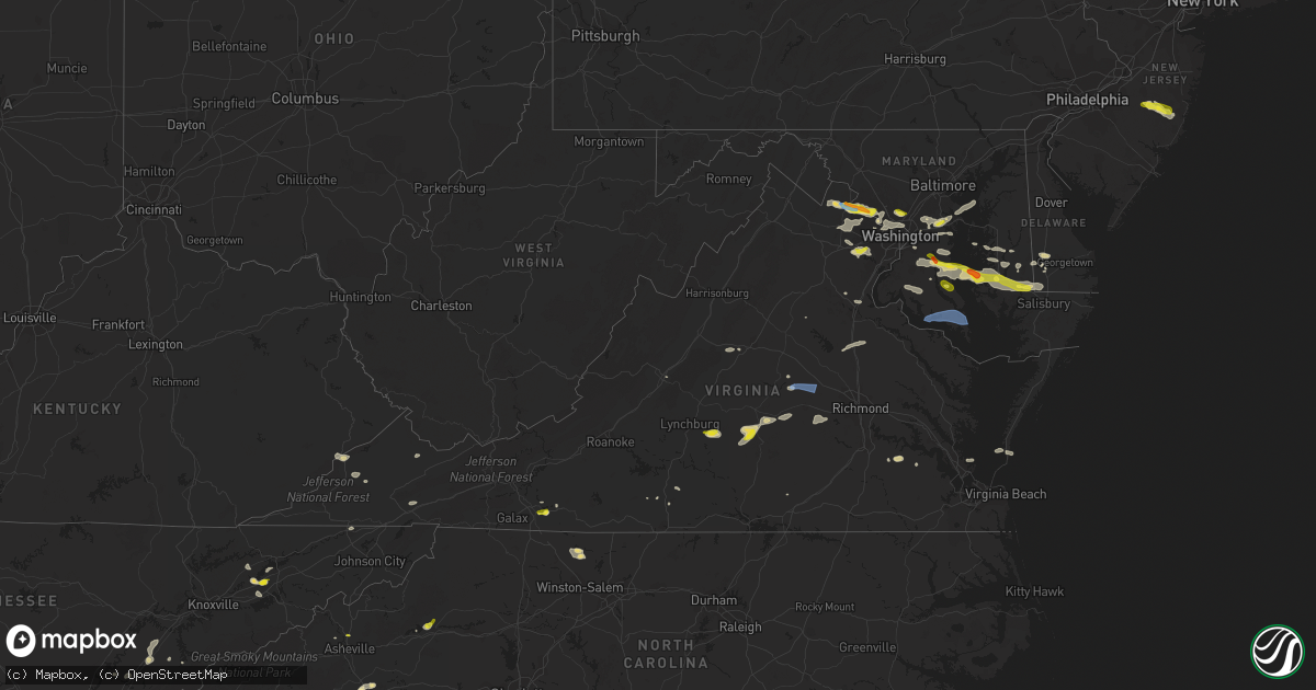
Hail Map in Virginia on June 2, 2022
Get this storm
June 2 map
$229
one time, instant access
Download today. No call, no setup
Keep the $229
Bought the map and want the full workflow? Apply the entire $229 to a subscription within 7 days. None of it is wasted.
Every map, not just this one
This buys you this map. Subscription and you get every map we run, in the markets you choose from a few cities to whole states to nationwide. Plus real-time alerts the moment a storm fires.
Contact data
Name, contact info, occupancy, even credit band for addresses in the footprint. You go from where it hit to who to call.
Become the source they trust
Unlimited branding weather history reports on demand. You already have the documented answer ready for the property owner, and you are the one who showed up with it.
Property data and RoofTrace estimates
Pull up any address you have got, its value and the exact code rules for that jurisdiction, straight from One Click Code. Then RoofTrace estimates the squares, pitch, and roof value, priced the way you price.
Storm reports in Virginia
Virginia
| Date | Description |
|---|---|
| 06/02/20226:30 PM CDT | Power outages likely due to storm reported in the southwest portion of surry county. Time estimated from radar. |
| 06/02/20225:55 PM CDT | Trees and power lines throughout northumberland county. Time estimated from radar. |
| 06/02/20225:52 PM CDT | Tree down on route 3 near beulah baptist church. Time estimated. |
| 06/02/20225:45 PM CDT | Trees and power lines down in route 616 in the vicinity of oakland road in richmond county. Time estimated from radar. |
| 06/02/20225:35 PM CDT | Tree down across va route 30 near vfw rd. Time estimated by radar. |
| 06/02/20225:24 PM CDT | Power pole down on 1400 block of tappahannock blvd. Time estimated from radar. |
| 06/02/20225:17 PM CDT | Tree down on e river rd near belmont rd. Time estimated from radar. |
| 06/02/20225:15 PM CDT | Power line down near the intersection of clark store road and tidewater trail. Time estimated. |
| 06/02/20225:13 PM CDT | Tree down on route 17 and wheatland road. Time estimated from radar. |
| 06/02/20225:12 PM CDT | Cluster of over 200 power outages likely caused by storm near loretto. Time estimated from radar. |
| 06/02/20225:12 PM CDT | Power pole down on centralia road. Time estimated from radar. |
| 06/02/20225:10 PM CDT | Tree down on venter rd near us highway 360. |
| 06/02/20225:03 PM CDT | Tree down on enfield rd near haileys court. Time estimated from radar. |
| 06/02/20225:00 PM CDT | Cluster of around 2...500 power outages likely due to storm northeast of mechanicsville and atlee. Time estimated. |
| 06/02/20225:00 PM CDT | Tree down on power lines on 11800 block of winterpock road. Time estimated. |
| 06/02/20224:59 PM CDT | Tree down on sparta rd near pendleton rd. |
| 06/02/20224:58 PM CDT | Tree down across king william avenue near dabneys mill rd. Time estimated from radar. |
| 06/02/20224:55 PM CDT | Trees and power lines down throughout caroline county... Especially near bowling green. There are thousands of power outages in the county. Time estimated. |
| 06/02/20224:52 PM CDT | Tree down on us-301. Time estimated from radar. |
| 06/02/20224:47 PM CDT | Trees down on route 1 and gatewood road and also near the intersection of paige and sunshine school road in caroline county. Time estimated. |
| 06/02/20224:45 PM CDT | Tree down on harrisons road. Time estimated from radar. |
| 06/02/20224:44 PM CDT | Report from mping: 1-inch tree limbs broken; shingles blown off. |
| 06/02/20224:38 PM CDT | Trees down. East lanes of river road closed. |
| 06/02/20224:35 PM CDT | Tree down on dover road near crozier. Time estimated. |
| 06/02/20224:35 PM CDT | Numerous reports of trees down in and around montpelier and beaverdam. Time estimated. |
| 06/02/20224:33 PM CDT | Tree down in 6000 block of morris road. |
| 06/02/20224:31 PM CDT | Tree down on route 604 near the vicinity of bel plains drive |
| 06/02/20224:30 PM CDT | Tree down on 1900 block of river road. Time estimated. |
| 06/02/20224:25 PM CDT | Tree down in 7000 block of courthouse road. |
| 06/02/20224:25 PM CDT | Tree down near intersection of partlow road and wallers road. |
| 06/02/20224:25 PM CDT | Tree down in 300 block of partlow road. |
| 06/02/20224:24 PM CDT | Tree down near on the 700 block of leeland road |
| 06/02/20224:20 PM CDT | Tree down in 12000 block of orange plank road. |
| 06/02/20224:18 PM CDT | Tree down on 2400 block of cumberland road. Time estimated. |
| 06/02/20224:15 PM CDT | Cluster of over 1...000 power outages caused by storm in prospect. Time estimated. |
| 06/02/20224:10 PM CDT | Tree down on five forks road east of pamplin. Time estimated. |
| 06/02/20224:10 PM CDT | Tree down near the 8880 block of fredericks hall road. Time estimated. |
| 06/02/20224:10 PM CDT | Two trees down on gladesboro road. |
| 06/02/20224:07 PM CDT | Trees down resulting in lane closures. |
| 06/02/20224:03 PM CDT | Tree down and powerline wires down on the 20000 block of llama lane |
| 06/02/20224:01 PM CDT | Tree down blocking a lane of richmond hwy |
| 06/02/20224:01 PM CDT | Trees and power lines down on sawmill road. |
| 06/02/20224:01 PM CDT | Tree down on noble lane. |
| 06/02/20224:00 PM CDT | Tree down on power line on raccoon lane. Time estimated. |
| 06/02/20223:59 PM CDT | Tree down on powerline on richmond hwy near pamplin va. |
| 06/02/20223:56 PM CDT | Tree down near the intersection of constitution highway and zachary taylor highway |
| 06/02/20223:56 PM CDT | Tree down on country club rd. |
| 06/02/20223:56 PM CDT | Tree down and powerline wires down near the intersection of verdiersville road and constitution highway |
| 06/02/20223:47 PM CDT | Tree down and powerline wires down on the 22000 block of constitution hwy |
| 06/02/20223:45 PM CDT | Two trees down in union mills. Time estimated. |
| 06/02/20223:45 PM CDT | Tree down near the intersection of spotswood trail and carter winky road |
| 06/02/20223:42 PM CDT | Around 2...500 power outages caused by storm centered near lake monticello. Time estimated. |
| 06/02/20223:34 PM CDT | Tree down on white rock road. |
| 06/02/20223:31 PM CDT | Tree down near louisa rd and black cat rd |
| 06/02/20223:20 PM CDT | Tree down near intersection of scottsville rd and college dr. |
| 06/02/20223:19 PM CDT | Tree down near intersection of old lynchburg rd and hickory st. |
| 06/02/20223:19 PM CDT | Multiple trees and large branches downed in and near charlottesville |
| 06/02/20223:18 PM CDT | Tree onto a structure at 497 hickory st. |
| 06/02/20223:13 PM CDT | Tree down on hutson rd. |
| 06/02/20223:10 PM CDT | Reported by public. Limbs down... Small trees snapped off... Several large trees uprooted. |
| 06/02/20223:06 PM CDT | Numerous trees down across the western portion of the county as well as the city of charlottesville. |
| 06/02/20223:06 PM CDT | Two trees down near the intersection of state route 617 and us-29 |
| 06/02/20223:04 PM CDT | Tree down near thomas nelson highway and buckcreek lane |
| 06/02/20223:01 PM CDT | Tree down at the 500 block of cub creek rd |
| 06/02/20222:56 PM CDT | Thunderstorm winds blew a few trees down blocking johnson mill road. |
| 06/02/20222:52 PM CDT | Tree down in 5000 block of cub creek road. |
| 06/02/20222:50 PM CDT | A couple trees down near where route 650 meets hurricane road. |
| 06/02/20222:46 PM CDT | A local report indicates 1.50 inch wind near 2 NE LEESBURG |
| 06/02/20222:46 PM CDT | Tree down on bob neal lane. |
| 06/02/20222:42 PM CDT | Multiple trees down near the rt 7 and dulles greenway intersection |
| 06/02/20222:42 PM CDT | A local report indicates 1.00 inch wind near 1 ESE LEESBURG |
| 06/02/20222:42 PM CDT | A local report indicates 1.50 inch wind near 2 E LEESBURG |
| 06/02/20222:38 PM CDT | A local report indicates 1.00 inch wind near LEESBURG |
| 06/02/20222:38 PM CDT | Tree down near the intersection of va-123/ox road and burke centre parkway |
| 06/02/20222:35 PM CDT | A local report indicates 1.00 inch wind near 2 SE MANASSAS PARK |
| 06/02/20222:35 PM CDT | Tree down on the 400 block of dry mill road sw |
| 06/02/20222:33 PM CDT | Multiple trees down in pittsylvania county in the dry fork area of the county. One tree on a house. |
| 06/02/20222:33 PM CDT | A local report indicates 1.00 inch wind near 2 NW MANASSAS PARK |
| 06/02/20222:32 PM CDT | Several reports of trees and wires down across northern loudoun county. Reports were most focused near the intersection of routes 7 and 9... Just to the west of leesbur |
| 06/02/20222:31 PM CDT | Numerous trees down between lexington and raphine in rockbridge county. |
| 06/02/20222:31 PM CDT | Tree down blocking the turning lane on mountain valley road near axton. |
| 06/02/20222:29 PM CDT | A local report indicates 1.00 inch wind near 3 S WATERFORD |
| 06/02/20222:29 PM CDT | Multiple trees down near the 1000 block of bridge view court |
| 06/02/20222:26 PM CDT | Tree down on the 3000 block of colonial highway |
| 06/02/20222:25 PM CDT | Thunderstorm winds blew down two large tree limbs along highway 107 just south of the intersection with sulphur springs road. |
| 06/02/20222:23 PM CDT | Tree down blocking one lane on kings mountain rd. |
| 06/02/20222:23 PM CDT | Tree fell on power lines and whole rdway blocked. |
| 06/02/20222:20 PM CDT | Large tree branches reported down on opal road near lees mill road. |
| 06/02/20222:20 PM CDT | Several trees reported down on doctor ralph stanley hwy. |
| 06/02/20222:18 PM CDT | Tree down on the 700 block of limestone road |
| 06/02/20222:15 PM CDT | Trees down in the glade spring and meadowview area. |
| 06/02/20222:02 PM CDT | Tree down near the intersection of monumnetal mills road and river hills road |
| 06/02/20222:01 PM CDT | Tree down near the intersection of waterford road and korea road |
| 06/02/20221:54 PM CDT | Tree down near the intersection of river lane and dam town road |
| 06/02/20221:47 PM CDT | Metal roofing removed from a mini storage facility |
| 06/02/20221:43 PM CDT | Tree down on the 700 block of rudasill mill road |
| 06/02/20221:37 PM CDT | A tree was also snapped nearby |
| 06/02/20221:34 PM CDT | Tree down on the 300 block of fletchers mill road |
| 06/02/202212:57 PM CDT | Two trees down on abbs valley road. |
| 06/02/202212:56 PM CDT | Tree down blocking road on eagle eyrie rd. |
| 06/02/202211:54 AM CDT | One tree down on baptist valley road and burkett drive. |
| 06/02/202211:48 AM CDT | Report from mping: 1-inch tree limbs broken; shingles blown off. |
| 06/02/202211:28 AM CDT | Multiple trees were downed by thunderstorm wind gusts between jewell ridge and richlands. |
| 06/02/202210:42 AM CDT | Multiple trees and power lines down through the area. Time estimated by radar. |
| 06/02/202210:30 AM CDT | Multiple trees and power lines down through the area. Small hail was also reported. |
| 06/02/20226:23 AM CDT | At 1122 AM EDT, a severe thunderstorm was located over Clintwood, moving east at 35 mph. HAZARD...60 mph wind gusts and quarter size hail. SOURCE...Radar indicated. IMPACT...Hail damage to vehicles is expected. Expect wind damage to roofs, siding, and trees. Locations impacted include... Clintwood, Haysi, John Flannagan Lake, Clinchco and McClure. |
| 06/02/20226:14 AM CDT | At 1114 AM EDT, a severe thunderstorm was located over Payne Gap, or 9 miles west of Clintwood, moving east at 20 mph. HAZARD...60 mph wind gusts and quarter size hail. SOURCE...Radar indicated. IMPACT...Hail damage to vehicles is expected. Expect wind damage to roofs, siding, and trees. Locations impacted include... Pound. |
| 06/02/20223:35 AM CDT | At 835 PM EDT, a severe thunderstorm was located near Cape Charles, moving east at 20 mph. HAZARD...60 mph wind gusts and quarter size hail. SOURCE...Radar indicated. IMPACT...Minor damage to vehicles is possible. Expect wind damage to trees and powerlines. This severe thunderstorm will be near... Cheriton and Bay View around 845 PM EDT.Other locations impacted by this severe thunderstorm includeCapeville, Townsend, Kiptopeke State Park, Oyster, Cheapside,Kiptopeke, Plantation and Dalbys. |
| 06/02/20223:21 AM CDT | At 820 PM EDT, severe thunderstorms were located along a line extending from near Salem to Glenvar to near Elliston-Lafayette, moving east at 25 mph. HAZARD...60 mph wind gusts. SOURCE...Radar indicated. IMPACT...Expect damage to roofs, siding, and trees. Locations impacted include... Salem... and Glenvar.This includes The following Location The Salem Fairgrounds. |
| 06/02/20223:04 AM CDT | At 804 PM EDT, a severe thunderstorm was located near Langley AFB, moving east at 20 mph. HAZARD...60 mph wind gusts. SOURCE...Radar indicated. IMPACT...Expect damage to trees and powerlines. This severe thunderstorm will be near... Grand View around 810 PM EDT.Other locations impacted by this severe thunderstorm include Dare,Messick, Fox Hill, Langley View and Plum Tree Island Refuge. |
| 06/02/20222:58 AM CDT | At 758 PM EDT, a severe thunderstorm was located near Surry, moving east at 35 mph. HAZARD...60 mph wind gusts. SOURCE...Radar indicated. IMPACT...Expect damage to trees and powerlines. This severe thunderstorm will be near... Fort Eustis around 820 PM EDT. Lee Hall around 825 PM EDT. Newport News and Denbigh around 830 PM EDT.Other locations impacted by this severe thunderstorm includeRushmere, Pons, Carrollton, Lackey, Chippokes State Park, Oriana,Bethel Church, Ellis Fork, Delk Crossroads and Lawson. |
| 06/02/20222:41 AM CDT | At 740 PM EDT, severe thunderstorms were located along a line extending from 7 miles southeast of Tangier to 10 miles northwest of Exmore to 6 miles northeast of Bavon, moving east at 45 mph. HAZARD...60 mph wind gusts and penny size hail. SOURCE...Radar indicated. IMPACT...Expect damage to trees and powerlines. Severe thunderstorms will be near... Onancock around 750 PM EDT. Exmore around 755 PM EDT. Onley around 800 PM EDT. Nassawadox around 805 PM EDT. Willis Wharf around 810 PM EDT.Other locations impacted by these severe thunderstorms includeBirdsnest, Harborton, Melfa, Jamesville, Silver Beach, Wachapreague,Machipongo, Wardtown, Franktown and Accomac. |
| 06/02/20222:26 AM CDT | At 726 PM EDT, a severe thunderstorm was located near Cabin Point, or near Waverly, moving east at 15 mph. HAZARD...60 mph wind gusts and quarter size hail. SOURCE...Radar indicated. IMPACT...Minor damage to vehicles is possible. Expect wind damage to trees and powerlines. This severe thunderstorm will be near... Cabin Point around 735 PM EDT. Claremont around 755 PM EDT. Dendron around 810 PM EDT. Surry, Elberon and Scotland around 815 PM EDT.Other locations impacted by this severe thunderstorm include TaylorsCorner, Booth Fork, Carsley, Newville, Spring Grove, Gwaltney Corner,Oak Hill Corner, Ellis Fork, Savedge and Barham. |
| 06/02/20222:23 AM CDT | At 722 PM EDT, severe thunderstorms were located along a line extending from near Deal Island to near Tylerton to Tangier, moving east at 45 mph. HAZARD...60 mph wind gusts and penny size hail. SOURCE...Radar indicated. IMPACT...Expect damage to trees and powerlines. Severe thunderstorms will be near... Lawsonia around 730 PM EDT. Marion Station around 740 PM EDT. Westover around 745 PM EDT. Parksley around 750 PM EDT. West Pocomoke around 755 PM EDT. Pocomoke City around 800 PM EDT.Other locations impacted by these severe thunderstorms includeHorntown, Hallwood, Mappsville, Cokesbury, Goodwill, Greenbackville,Kingston, Saxis, Wallops Island and Temperanceville. |
| 06/02/20222:03 AM CDT | At 702 PM EDT, severe thunderstorms were located along a line extending from near Millsboro to 6 miles southeast of Parsonsburg to near Snow Hill, moving east at 40 mph. HAZARD...60 mph wind gusts. SOURCE...Radar indicated. IMPACT...Expect damage to trees and powerlines. Severe thunderstorms will be near... Newark around 710 PM EDT. Berlin and Ocean Pines around 715 PM EDT. Cape Isle Of Wight around 720 PM EDT. Ocean City around 725 PM EDT.Other locations impacted by these severe thunderstorms includeBishop, Boxiron, Ocean City Municipality, Salisbury-Wicomico,Cokesbury, Bishopville, Public Landing, Ironshire, Willards and WestOcean City. |
| 06/02/202212:55 AM CDT | At 554 PM EDT, a severe thunderstorm was located over Macon, or near Powhatan, moving east at 55 mph. HAZARD...60 mph wind gusts and quarter size hail. SOURCE...Radar indicated. IMPACT...Minor damage to vehicles is possible. Expect wind damage to trees and powerlines. This severe thunderstorm will be near... Moseley and Sabot around 605 PM EDT. Manakin around 610 PM EDT. University Of Richmond and Bon Air around 620 PM EDT. Richmond, Virginia Commonwealth University, Downtown Richmond, Virginia Union University, Bensley, Bellwood and Lakeside around 625 PM EDT. Highland Springs and East Highland Park around 630 PM EDT.Other locations impacted by this severe thunderstorm includeMontrose, Sandston, Glendale, Pocahontas State Park, Skinquarter,Beach, Chamberlayne, Fine Creek Mills, Michaux and Atlee. |
| 06/02/202212:30 AM CDT | At 530 PM EDT, severe thunderstorms were located along a line extending from near Spotsylvania to 6 miles west of Ladysmith to near Montpelier, moving east at 35 mph. HAZARD...60 mph wind gusts and penny size hail. SOURCE...Radar indicated. IMPACT...Expect damage to trees and powerlines. Severe thunderstorms will be near... Ladysmith around 540 PM EDT. Ashland and Randolph Macon College around 550 PM EDT. Milford and Kings Dominion around 555 PM EDT. Bowling Green, Hanover and Dawn around 600 PM EDT. Fort A.p. Hill around 605 PM EDT. Mangohick around 610 PM EDT. Port Royal and Beulahville around 615 PM EDT.Other locations impacted by these severe thunderstorms includeChilesburg, Enfield, Golansville, Guinea, Corbin, Gum Tree, EtnaMills, Penola, Epworth and Gilman. |
| 06/02/202212:20 AM CDT | At 520 PM EDT, severe thunderstorms were located along a line extending from 6 miles southeast of Dillwyn to near Guinea Mills to near Farmville, moving northeast at 45 mph. HAZARD...60 mph wind gusts and quarter size hail. SOURCE...Radar indicated. IMPACT...Minor damage to vehicles is possible. Expect wind damage to trees and powerlines. Severe thunderstorms will be near... Cumberland around 530 PM EDT. Sunnyside around 535 PM EDT. Tobaccoville, Ballsville and Jetersville around 540 PM EDT. Cartersville and Trenholm around 545 PM EDT. Amelia Courthouse, Morven and Macon around 550 PM EDT. Powhatan around 555 PM EDT. Goochland and Chula around 600 PM EDT.Other locations impacted by these severe thunderstorms include RainesTavern, Crozier, Angola, Rock Castle, Oak Forest, Pilkinton, Maidens,Three Square, Irwin and Winterham. |
| 06/02/202212:05 AM CDT | At 505 PM EDT, a severe thunderstorm was located near Gladesboro, or near Fancy Gap, moving east at 30 mph. HAZARD...60 mph wind gusts and quarter size hail. SOURCE...Radar indicated. IMPACT...Hail damage to vehicles is expected. Expect wind damage to roofs, siding, and trees. Locations impacted include... Stuart... Ararat... Woolwine... Laurel Fork... Critz... Meadows Of Dan... and Mabry Mill. |
| 06/02/202212:04 AM CDT | At 504 PM EDT, severe thunderstorms were located along a line extending from near Mineral to near Cartersville, moving east at 35 mph. HAZARD...60 mph wind gusts and penny size hail. SOURCE...Radar indicated. IMPACT...Expect damage to trees and powerlines. Severe thunderstorms will be near... Mineral around 510 PM EDT. Goochland and Gum Spring around 520 PM EDT. Oilville around 530 PM EDT. Sabot around 535 PM EDT. Manakin around 540 PM EDT. Wyndham and Montpelier around 545 PM EDT.Other locations impacted by these severe thunderstorms includeOrchid, Crozier, Rock Castle, Louisa Airport, Vontay, Maidens, ThreeSquare, Irwin, Johnsons Springs and Gilman. |
| 06/02/202212:00 AM CDT | At 459 PM EDT, a severe thunderstorm was located over Appomattox, moving east at 25 mph. HAZARD...60 mph wind gusts and penny size hail. SOURCE...Radar indicated. IMPACT...Expect damage to trees and powerlines. This severe thunderstorm will be near... Prospect around 540 PM EDT. Farmville, Hampden Sydney and Longwood University around 545 PM EDT.Other locations impacted by this severe thunderstorm includeKingsville, Raines Tavern, Briery Creek Lake, Tuggle, Elam, Reeds,Allens Mill and Worsham. |
| 06/01/202211:36 PM CDT | At 436 PM EDT, severe thunderstorms were located along a line extending from near Orange to 6 miles east of Charlottesville, moving east at 30 mph. HAZARD...60 mph wind gusts. SOURCE...Radar indicated. IMPACT...Damaging winds will cause some trees and large branches to fall. This could injure those outdoors, as well as damage homes and vehicles. Roadways may become blocked by downed trees. Localized power outages are possible. Unsecured light objects may become projectiles. Locations impacted include... Orange, Campbell, Gordonsville, Cobham, Mine Run, Cismont, Rhoadesville, Parker, Barboursville, Verdiersville, Keswick, Montpelier Station, Madison Run, Gold Dale, Thornhill, Nasons, Logan, Montford, Lahore and Glenora. |
| 06/01/202211:34 PM CDT | At 433 PM EDT, severe thunderstorms were located along a line extending from near Boswells Tavern to 7 miles north of Centenary, moving east at 35 mph. HAZARD...60 mph wind gusts and penny size hail. SOURCE...Radar indicated. IMPACT...Expect damage to trees and powerlines. Severe thunderstorms will be near... Boswells Tavern around 440 PM EDT. Lake Monticello around 450 PM EDT. Palmyra and Fork Union around 455 PM EDT. Columbia and Kents Store around 505 PM EDT. Ferncliff and Fife around 510 PM EDT. Hadensville around 515 PM EDT.Other locations impacted by these severe thunderstorms include LouisaAirport, Green Springs, Shores, Central Plains, Bremo Bluff,Cohasset, Waldrop, Tabscott, Trevilians and Wares Crossroads. |
| 06/01/202211:33 PM CDT | At 432 PM EDT, severe thunderstorms were located along a line extending from 7 miles north of Centenary to near Riverville, moving southeast at 35 mph. HAZARD...60 mph wind gusts. SOURCE...Radar indicated. IMPACT...Expect damage to roofs, siding, and trees. Locations impacted include... Buckingham... Amherst... Appomattox... Dillwyn... Bent Creek... Appomattox National Historic Park... and Sheppards. |
| 06/01/202211:28 PM CDT | At 428 PM EDT, severe thunderstorms were located along a line extending from 6 miles northeast of Schuyler to near Shipman, moving east at 30 mph. HAZARD...60 mph wind gusts. SOURCE...Radar indicated. IMPACT...Damaging winds will cause some trees and large branches to fall. This could injure those outdoors, as well as damage homes and vehicles. Roadways may become blocked by downed trees. Localized power outages are possible. Unsecured light objects may become projectiles. Locations impacted include... Shipman, Schuyler, Arrington, Scottsville, Esmont, Norwood, Glendower, Keene, Alberene, Damon, Wingina and Buffalo Springs. |
| 06/01/202211:05 PM CDT | At 405 PM EDT, a severe thunderstorm was located near Crozet, or 10 miles west of Charlottesville, moving east at 30 mph. HAZARD...60 mph wind gusts and quarter size hail. SOURCE...Radar indicated. IMPACT...Damaging winds will cause some trees and large branches to fall. This could injure those outdoors, as well as damage homes and vehicles. Roadways may become blocked by downed trees. Localized power outages are possible. Unsecured light objects may become projectiles. Locations impacted include... Charlottesville, Crozet, Westmoreland, Hollymead, Ivy, Cismont, North Garden, Newcomb Hall, Batesville, Boyd Tavern, Yancey Mills, Monticello, Woodridge, Keswick, Stony Point, Flordon, Carrsbrook, Shadwell, Barracks and Overton. |
| 06/01/202210:52 PM CDT | At 352 PM EDT, a severe thunderstorm was located over Countryside, or near Poolesville, moving east at 30 mph. HAZARD...60 mph wind gusts and half dollar size hail. SOURCE...Trained weather spotters have reported quarter size and larger hail near Leesburg. IMPACT...Damaging winds will cause some trees and large branches to fall. This could injure those outdoors, as well as damage homes and vehicles. Roadways may become blocked by downed trees. Localized power outages are possible. Unsecured light objects may become projectiles. Locations impacted include... Germantown, Rockville, Bethesda, Gaithersburg, Olney, Lowes Island, Aspen Hill, Potomac, North Bethesda, Montgomery Village, North Potomac, Redland, Great Falls, Colesville, Kemp Mill, Countryside, Chevy Chase, North Kensington, South Kensington and Forest Glen. |
| 06/01/202210:52 PM CDT | At 351 PM EDT, severe thunderstorms were located along a line extending from near Marion Wytheville to near Atkins to near Sugar Grove, moving east at 35 mph. HAZARD...60 mph wind gusts. SOURCE...Radar indicated. IMPACT...Expect damage to roofs, siding, and trees. Locations impacted include... Wytheville... Rural Retreat... Mount Rogers National Recreation Area... Speedwell... Sugar Grove... Nebo... and Atkins. |
| 06/01/202210:50 PM CDT | At 349 PM EDT, a severe thunderstorm was located near Java, or near Chatham, moving east at 30 mph. HAZARD...60 mph wind gusts and quarter size hail. SOURCE...Radar indicated. IMPACT...Hail damage to vehicles is expected. Expect wind damage to roofs, siding, and trees. Locations impacted include... South Boston... Halifax... Redoak... Clover... Ingram... Mt Airy... and Nathalie. |
| 06/01/202210:36 PM CDT | At 336 PM EDT, a severe thunderstorm was located over Cornwall, or 7 miles northeast of Buena Vista, moving east at 40 mph. HAZARD...60 mph wind gusts and quarter size hail. SOURCE...Radar indicated. IMPACT...Damaging winds will cause some trees and large branches to fall. This could injure those outdoors, as well as damage homes and vehicles. Roadways may become blocked by downed trees. Localized power outages are possible. Unsecured light objects may become projectiles. Locations impacted include... Waynesboro, Stuarts Draft, Sherando, Shipman, Schuyler, Wintergreen, Montebello, Afton, Lyndhurst, Nellysford, Greenville, Arrington, Lovingston, Middlebrook, North Garden, Covesville, Tyro, Norwood, Jonesboro and Faber. |
| 06/01/202210:27 PM CDT | At 327 PM EDT, a severe thunderstorm was located over Cornwall, or near Buena Vista, moving east at 50 mph. HAZARD...60 mph wind gusts and quarter size hail. SOURCE...Radar indicated. IMPACT...Hail damage to vehicles is expected. Expect wind damage to roofs, siding, and trees. Locations impacted include... Lexington... Buena Vista... Amherst... Buchanan... Glasgow... Goshen... and Forks Of Buffalo.This includes The following Location VMI. |
| 06/01/202210:22 PM CDT | At 322 PM EDT, a severe thunderstorm was located near Bull Run, or near Centreville, moving east at 25 mph. HAZARD...60 mph wind gusts and quarter size hail. SOURCE...Radar indicated. IMPACT...Damaging winds will cause some trees and large branches to fall. This could injure those outdoors, as well as damage homes and vehicles. Roadways may become blocked by downed trees. Localized power outages are possible. Unsecured light objects may become projectiles. Locations impacted include... Centreville, Annandale, Springfield, Fort Belvoir, Lake Ridge, Burke, Linton Hall, Lincolnia, Lorton, Franconia, Bull Run, Newington, I395 and I495 Interchange, Manassas, West Springfield, Sudley, Manassas Park, Fairfax Station, North Springfield and Ravensworth. |
| 06/01/202210:06 PM CDT | At 305 PM EDT, severe thunderstorms were located along a line extending from Southern Smith Mountain Lake to near Snow Creek to near Figsboro, moving east at 20 mph. HAZARD...60 mph wind gusts and quarter size hail. SOURCE...Radar indicated. IMPACT...Hail damage to vehicles is expected. Expect wind damage to roofs, siding, and trees. Locations impacted include... Martinsville... Chatham... Gretna... Axton... Penhook... Callands... and Sydnorsville.This includes The following Location The Martinsville Speedway. |
| 06/01/202210:05 PM CDT | At 305 PM EDT, severe thunderstorms were located along a line extending from near Quarry to Pine Crest, moving east at 30 mph. HAZARD...60 mph wind gusts and quarter size hail. SOURCE...Radar indicated. IMPACT...Hail damage to vehicles is expected. Expect wind damage to roofs, siding, and trees. Locations impacted include... Marion... Saltville... Chilhowie... Mount Rogers National Recreation Area... Nebo... Hungry Mother State Park... and Broadford. |
| 06/01/202210:04 PM CDT | At 304 PM EDT, a severe thunderstorm was located near Quarry, or 7 miles southwest of Saltville, moving east at 25 mph. HAZARD...60 mph wind gusts and penny size hail. SOURCE...Radar indicated. IMPACT...Expect damage to roofs, siding, and trees. Locations impacted include... Abingdon, Glade Spring, Lindell and Emory-Meadow View. This includes Interstate 81 in Virginia between mile markers 21 and34. |
| 06/01/20229:53 PM CDT | At 252 PM EDT, a severe thunderstorm was located near Trammel, or 9 miles southeast of Clintwood, moving east at 35 mph. HAZARD...60 mph wind gusts and penny size hail. SOURCE...Radar indicated. IMPACT...Expect damage to roofs, siding, and trees. Locations impacted include... Davenport, Trammel, McClure, Nora and Vansant. |
| 06/01/20229:48 PM CDT | At 247 PM EDT, a severe thunderstorm was located 7 miles east of Sperryville, or 14 miles north of Culpeper, moving east at 30 mph. HAZARD...60 mph wind gusts and quarter size hail. SOURCE...Radar indicated. IMPACT...Damaging winds will cause some trees and large branches to fall. This could injure those outdoors, as well as damage homes and vehicles. Roadways may become blocked by downed trees. Localized power outages are possible. Unsecured light objects may become projectiles. Locations impacted include... Warrenton, Bealeton, New Baltimore, Opal, Washington, Viewtown, Hackleys Crossroads, Amissville, Jeffersonton, Orlean, Turnbull, Five Forks, Rock Mills and Airlie. |
| 06/01/20229:47 PM CDT | At 246 PM EDT, severe thunderstorms were located along a line extending from near Sandy Ridge to near Ararat, moving east at 10 mph. HAZARD...60 mph wind gusts and quarter size hail. SOURCE...Radar indicated. IMPACT...Hail damage to vehicles is expected. Expect wind damage to roofs, siding, and trees. Locations impacted include... Pilot Mountain... Stuart... Danbury... Francisco... Sandy Ridge... King... and Ridgeway. |
| 06/01/20229:39 PM CDT | At 239 PM EDT, a severe thunderstorm was located near Staunton, moving east at 30 mph. HAZARD...60 mph wind gusts and quarter size hail. SOURCE...Radar indicated. IMPACT...Damaging winds will cause some trees and large branches to fall. This could injure those outdoors, as well as damage homes and vehicles. Roadways may become blocked by downed trees. Localized power outages are possible. Unsecured light objects may become projectiles. Locations impacted include... Staunton, Grottoes, Crimora, Verona, Weyers Cave, New Hope, Mount Sidney, Port Republic, Fort Defiance and Staunton Airport. |
| 06/01/20229:33 PM CDT | At 233 PM EDT, severe thunderstorms were located along a line extending from Figsboro to Sanville, moving east at 15 mph. HAZARD...60 mph wind gusts and quarter size hail. SOURCE...Radar indicated. IMPACT...Hail damage to vehicles is expected. Expect wind damage to roofs, siding, and trees. Locations impacted include... Bassett... Stanleytown... Oak Level... Mountain Valley... Philpott Dam... Figsboro... and Snow Creek. |
| 06/01/20229:03 PM CDT | At 203 PM EDT, a severe thunderstorm was located over Wayside, or 7 miles west of Union, moving east at 35 mph. HAZARD...60 mph wind gusts and quarter size hail. SOURCE...Radar indicated. IMPACT...Hail damage to vehicles is expected. Expect wind damage to roofs, siding, and trees. Locations impacted include... Alleghany... White Sulphur Springs... Ronceverte... Union... New Castle... Paint Bank... and Laurel Branch. |
| 06/01/20227:25 PM CDT | Numerous trees down and a barn roof was torn off in the vicinity of the 7000 block of candy meadow lane. |
| 06/01/20227:25 PM CDT | Cluster of around 500 power likely caused by storm centered just south of exmore. Time estimated from radar. |
| 06/01/20227:25 PM CDT | Two trees down on peaceful drive just south of interstate 81 in the northwest corner of roanoke county. |
| 06/01/20227:04 PM CDT | Several power outages caused by storm just south of surry. Time estimated. |
| 06/01/20227:01 PM CDT | Mesonet station xhak onancock. |
| 06/01/20227:00 PM CDT | 51 knot |
All States Impacted by Hail Map on June 2, 2022
Cities Impacted by Hail Map on June 2, 2022
- Manassas, VA
- Gainesville, VA
- Catharpin, VA
- Seaford, DE
- Morristown, TN
- Raven, VA
- Chatham, VA
- Saint Paul, VA
- Claiborne, MD
- Saint Michaels, MD
- Mcdaniel, MD
- Woodford, VA
- Ruther Glen, VA
- Beaverdam, VA
- Decatur, AL
- Fredericksburg, VA
- Stafford, VA
- Charlottesville, VA
- Kingsport, TN
- Dalton, GA
- Sugar Valley, GA
- La Fayette, GA
- Summerville, GA
- Cherokee, AL
- Powhatan, VA
- Cumberland, VA
- Spur, TX
- El Paso, TX
- Lovington, NM
- Plains, TX
- Denver City, TX
- Tatum, NM
- Pinon, NM
- Weed, NM
- Gail, TX
- Paeonian Springs, VA
- Round Hill, VA
- Hamilton, VA
- Leesburg, VA
- Sterling, VA
- Gaithersburg, MD
- Potomac, MD
- Germantown, MD
- Poolesville, MD
- Dickerson, MD
- Ashburn, VA
- Great Falls, VA
- Rockville, MD
- Purcellville, VA
- Vienna, VA
- Hughesville, MD
- Jefferson, TX
- Harvest, AL
- Lamesa, TX
- Clyde, TX
- Davidsonville, MD
- Edgewater, MD
- Jumping Branch, WV
- Forked River, NJ
- Pemberton, NJ
- Browns Mills, NJ
- Manchester Township, NJ
- Vincentown, NJ
- Columbia, VA
- Suitland, MD
- Andrews Air Force Base, MD
- Temple Hills, MD
- Calhoun, TN
- Riceville, TN
- Brandon, MS
- Prospect, VA
- Dillwyn, VA
- Farmville, VA
- Appomattox, VA
- Pamplin, VA
- Hobbs, NM
- Seminole, TX
- Aliceville, AL
- Cloudcroft, NM
- Vernon, AL
- Linkwood, MD
- Chesapeake Beach, MD
- Vienna, MD
- Huntingtown, MD
- Woolford, MD
- Sunderland, MD
- Delmar, MD
- Prince Frederick, MD
- Trappe, MD
- Upper Marlboro, MD
- Cambridge, MD
- Laurel, DE
- Delmar, DE
- Rhodesdale, MD
- East New Market, MD
- Owings, MD
- Brandywine, MD
- Mardela Springs, MD
- Capitan, NM
- Roswell, NM
- Afton, VA
- North Garden, VA
- Greenwood, VA
- Poquoson, VA
- Dendron, VA
- Delhi, LA
- Tallulah, LA
- Easton, MD
- Fairfax Station, VA
- Fairfax, VA
- Clifton, VA
- Centreville, VA
- Bel Alton, MD
- Mechanicsville, MD
- La Plata, MD
- Charlotte Hall, MD
- Winchester, TN
- Sewanee, TN
- Belvidere, TN
- Sherwood, TN
- Decatur, TN
- Athens, GA
- Preston, MD
- Morton, TX
- Tokio, TX
- Brownfield, TX
- Levelland, TX
- Littlefield, TX
- Whiteface, TX
- Unionville, VA
- East Flat Rock, NC
- Flat Rock, NC
- Bowie, MD
- Hillsville, VA
- Laurel Fork, VA
- Tarzan, TX
- Ooltewah, TN
- Bridgeville, DE
- Federalsburg, MD
- Dunkirk, MD
- Lothian, MD
- Friendship, MD
- Tracys Landing, MD
- Deale, MD
- Gretna, VA
- Mayking, KY
- Jenkins, KY
- Whitesburg, KY
- Pound, VA
- Morganton, NC
- Oxford, MD
- Hurlock, MD
- Cape Charles, VA
- Rutledge, TN
- Leicester, NC
- Spout Spring, VA
- Concord, VA
- Cartersville, VA
- Rising Star, TX
- May, TX
- Okatie, SC
- Ridgeland, SC
- Coeburn, VA
- Wise, VA
- Silver Spring, MD
- Ackerly, TX
- Rome, GA
- Silver Creek, GA
- Weaverville, NC
- Pollock, LA
- Dry Prong, LA
- Bentley, LA
- Snyder, TX
- Colorado City, TX
- Glenmora, LA
- Fort Stockton, TX
- Moseley, VA
- Amelia Court House, VA
- South Hill, VA
- Philadelphia, TN
- Athens, TN
- Sweetwater, TN
- Niota, TN
- Pasadena, MD
- Arnold, MD
- Gibson Island, MD
- Waverly, VA
- Spring Grove, VA
- Taft, TN
- Fayetteville, TN
- Ardmore, TN
- Big Spring, TX
- Port Republic, MD
- Buena Vista, VA
- Annapolis, MD
- Severna Park, MD
- Crofton, MD
- Crownsville, MD
- Odenton, MD
- Laurel, MD
- Gambrills, MD
- Glenn Dale, MD
- Abingdon, VA
- Meadowview, VA
- Westfield, NC
- King, NC
- Germanton, NC
- Walnut Cove, NC
- Danbury, NC
- Talbott, TN
- Jefferson City, TN
- New Market, TN
- Blairs, VA
- Fancy Gap, VA
- Jal, NM
- Andalusia, AL
- Meadows Of Dan, VA
- Aldie, VA
- Middleburg, VA
- Chantilly, VA
- Disputanta, VA
- Madisonville, TN
- Jasper, AL
- Arley, AL
- Double Springs, AL
- Jayton, TX
- Alamogordo, NM
- Meadow, TX
- Seagraves, TX
- Pioneer, LA
- Chatsworth, GA
- Glen Echo, MD
- Cabin John, MD
- Bethesda, MD
- McLean, VA
- Takoma Park, MD
- Chevy Chase, MD
- Washington, DC
- Dandridge, TN
- Nebo, NC
- Greenwood, DE
- Manchester, GA
- Woodbury, GA
- Lena, LA
- Colfax, LA
- Boyce, LA
- Loop, TX
- Lenorah, TX
- New Iberia, LA
- Bunkie, LA
- Morrow, LA
- Sulligent, AL
- Lecompte, LA
- Alexandria, LA
- Pineville, LA
- Fort Bliss, TX
- Oakdale, LA
- Hendersonville, NC
- Zirconia, NC
- Louin, MS
- Forest Hill, LA
- Trout, LA
- Georgetown, LA
- Mountainair, NM
- Saluda, NC
- Plains, GA
- Marksville, LA
- Deville, LA
- Center Point, LA
- Effie, LA
- Mamou, LA
- Baytown, TX
- Albany, TX
- Willard, NM
- Socorro, NM
- Greenwood Springs, MS
- Beaverton, AL
- Winfield, AL
- Guin, AL
- Gattman, MS
- Caledonia, MS
- Fayette, AL
- Arnaudville, LA
- Beaumont, TX
- Port Arthur, TX
- Plaucheville, LA
- Evergreen, LA
- Pelahatchie, MS
- Pulaski, MS
- Morton, MS
- Tahoka, TX
- Odonnell, TX
- Repton, AL
- Frisco City, AL
- Forest, MS
- Jasper, TN
- Sequatchie, TN
- South Pittsburg, TN
- Clayton, AL
- Abilene, TX
- Van Horn, TX
- Woodworth, LA
- Ville Platte, LA
- Asheville, NC
- Goldthwaite, TX
- Dugspur, VA
- Conway, SC
- Anton, TX
- Petersburg, TN
- Stanton, TX
- Hawley, TX
- Port Gibson, MS
- Pattison, MS
- Lueders, TX
- Monroe, LA
- Monroeville, AL
- Welch, TX
- Truth Or Consequences, NM
- Dickens, TX
- Nederland, TX
- Moran, TX
- Stringer, MS
- Anson, TX
- Stamford, TX
- Avoca, TX
- Natchitoches, LA
- Delcambre, LA
- Erath, LA
- Maidens, VA
- State Farm, VA
- Goochland, VA
- Crozier, VA
- Bushwood, MD
- Abell, MD
- Great Mills, MD
- Patuxent River, MD
- Coltons Point, MD
- Lexington Park, MD
- Callaway, MD
- Hollywood, MD
- California, MD
- Leonardtown, MD
- Avenue, MD
- Park Hall, MD
- White Pine, TN
- Saint Leonard, MD
- Claunch, NM
- Eunice, NM
- Monument, NM
- Midland, TX
- Andrews, TX
- Jonesville, LA


