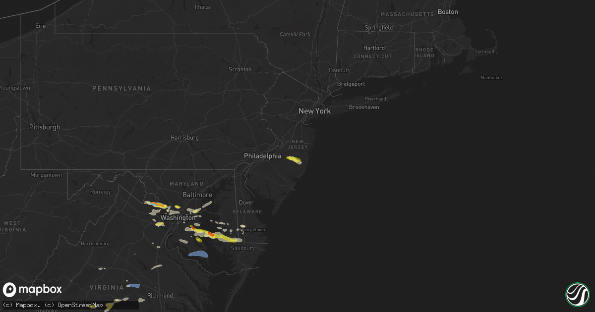
Hail Map in New Jersey on June 2, 2022
Get this storm
June 2 map
$229
one time, instant access
Download today. No call, no setup
Keep the $229
Bought the map and want the full workflow? Apply the entire $229 to a subscription within 7 days. None of it is wasted.
Every map, not just this one
This buys you this map. Subscription and you get every map we run, in the markets you choose from a few cities to whole states to nationwide. Plus real-time alerts the moment a storm fires.
Contact data
Name, contact info, occupancy, even credit band for addresses in the footprint. You go from where it hit to who to call.
Become the source they trust
Unlimited branding weather history reports on demand. You already have the documented answer ready for the property owner, and you are the one who showed up with it.
Property data and RoofTrace estimates
Pull up any address you have got, its value and the exact code rules for that jurisdiction, straight from One Click Code. Then RoofTrace estimates the squares, pitch, and roof value, priced the way you price.
Storm reports in New Jersey
New Jersey
| Date | Description |
|---|---|
| 06/02/20224:45 PM CDT | Downed wires and vehicle fire. Time estimated via radar. |
| 06/02/20224:18 PM CDT | A couple of trees or large limbs snapped in woodland twp. Time estimated from radar. |
| 06/02/20224:10 PM CDT | Some large tree limbs downed in presidential lakes. Time estimated from radar. |
| 06/02/20224:07 PM CDT | Multiple trees and wires reported down. Time estimated via radar. |
| 06/02/20224:05 PM CDT | Tree and wires down on 3rd ave. Time estimated from radar. |
| 06/02/20224:05 PM CDT | Downed wires with live wires touching ground. |
| 06/02/20224:02 PM CDT | Tree down blocking road. Time estimated via radar. |
| 06/02/20223:38 PM CDT | Em office reported tree that fell on a house. Time estimated via radar. |
| 06/02/20223:33 PM CDT | Em office reported a tree that fell on a house. Time estimated via radar. |
| 06/02/20223:33 PM CDT | Sent in pictures of trees down in yard. Time estimated via radar. |
| 06/02/20223:33 PM CDT | Trees downed in edgewater park with power outages. Time estimated from radar. |
| 06/02/20223:32 PM CDT | Downed wires on ground. Time estimated via radar. |
| 06/02/20223:30 PM CDT | Downed power lines on warren street. Time estimated via radar. |
| 06/02/20223:30 PM CDT | One tree uprooted and another tree had large branches snapped off. |
| 06/02/202212:26 AM CDT | At 526 PM EDT, a severe thunderstorm was located over Old Halfway, or 17 miles southwest of Toms River, moving east at 30 mph. HAZARD...60 mph wind gusts and half dollar size hail. SOURCE...Radar indicated. IMPACT...Minor damage to vehicles is possible. Wind damage to roofs, siding, trees, and power lines is possible. Locations impacted include... Toms River, Barnegat, Beachwood, Presidential Lakes Estates, Seaside Heights, Lakehurst, Surf City, Holiday City South, Pleasant Plains, Warren Grove, Chatsworth, Dover Beaches South, Presidential Lakes, Holiday City-Berkeley, Bamber Lake, Cedar Glen Lakes, Whiting, Brookville, Pine Ridge At Crestwood and Old Halfway.This includes Garden State Parkway between mile markers 62 and 84. |
| 06/01/202211:48 PM CDT | At 448 PM EDT, a severe thunderstorm was located over Mount Holly, or 16 miles south of Trenton, moving east at 30 mph. HAZARD...60 mph wind gusts and quarter size hail. SOURCE...Radar indicated. IMPACT...Minor damage to vehicles is possible. Wind damage to roofs, siding, trees, and power lines is possible. Locations impacted include... Toms River, Medford, Lumberton, Florence, Burlington, Mount Holly, Presidential Lakes Estates, Lakehurst, Pemberton, Wrightstown, Warren Grove, Leisuretowne, Chatsworth, Jacksonville, Georgetown, Presidential Lakes, Holiday City-Berkeley, Bamber Lake, Cedar Glen Lakes and Whiting.This includes the following highways... New Jersey Turnpike between exits 5 and 6A. Interstate 295 in New Jersey between mile markers 39 and 54. |
| 06/01/202210:45 PM CDT | At 344 PM EDT, a severe thunderstorm was located over Oradell, or over Paramus, moving southeast at 25 mph. HAZARD...60 mph wind gusts. SOURCE...Radar indicated. IMPACT...Expect damage to trees and power lines. This severe thunderstorm will be near... Bergenfield and Norwood around 350 PM. Fort Lee and Englewood around 400 PM. Yonkers, Harlem and Riverdale around 405 PM. Mott Haven, East Tremont and Bronxville around 410 PM. New Rochelle, Co-op City and City Island around 415 PM. |
All States Impacted by Hail Map on June 2, 2022
Cities Impacted by Hail Map on June 2, 2022
- Manassas, VA
- Gainesville, VA
- Catharpin, VA
- Seaford, DE
- Morristown, TN
- Raven, VA
- Chatham, VA
- Saint Paul, VA
- Claiborne, MD
- Saint Michaels, MD
- Mcdaniel, MD
- Woodford, VA
- Ruther Glen, VA
- Beaverdam, VA
- Decatur, AL
- Fredericksburg, VA
- Stafford, VA
- Charlottesville, VA
- Kingsport, TN
- Dalton, GA
- Sugar Valley, GA
- La Fayette, GA
- Summerville, GA
- Cherokee, AL
- Powhatan, VA
- Cumberland, VA
- Spur, TX
- El Paso, TX
- Lovington, NM
- Plains, TX
- Denver City, TX
- Tatum, NM
- Pinon, NM
- Weed, NM
- Gail, TX
- Paeonian Springs, VA
- Round Hill, VA
- Hamilton, VA
- Leesburg, VA
- Sterling, VA
- Gaithersburg, MD
- Potomac, MD
- Germantown, MD
- Poolesville, MD
- Dickerson, MD
- Ashburn, VA
- Great Falls, VA
- Rockville, MD
- Purcellville, VA
- Vienna, VA
- Hughesville, MD
- Jefferson, TX
- Harvest, AL
- Lamesa, TX
- Clyde, TX
- Davidsonville, MD
- Edgewater, MD
- Jumping Branch, WV
- Forked River, NJ
- Pemberton, NJ
- Browns Mills, NJ
- Manchester Township, NJ
- Vincentown, NJ
- Columbia, VA
- Suitland, MD
- Andrews Air Force Base, MD
- Temple Hills, MD
- Calhoun, TN
- Riceville, TN
- Brandon, MS
- Prospect, VA
- Dillwyn, VA
- Farmville, VA
- Appomattox, VA
- Pamplin, VA
- Hobbs, NM
- Seminole, TX
- Aliceville, AL
- Cloudcroft, NM
- Vernon, AL
- Linkwood, MD
- Chesapeake Beach, MD
- Vienna, MD
- Huntingtown, MD
- Woolford, MD
- Sunderland, MD
- Delmar, MD
- Prince Frederick, MD
- Trappe, MD
- Upper Marlboro, MD
- Cambridge, MD
- Laurel, DE
- Delmar, DE
- Rhodesdale, MD
- East New Market, MD
- Owings, MD
- Brandywine, MD
- Mardela Springs, MD
- Capitan, NM
- Roswell, NM
- Afton, VA
- North Garden, VA
- Greenwood, VA
- Poquoson, VA
- Dendron, VA
- Delhi, LA
- Tallulah, LA
- Easton, MD
- Fairfax Station, VA
- Fairfax, VA
- Clifton, VA
- Centreville, VA
- Bel Alton, MD
- Mechanicsville, MD
- La Plata, MD
- Charlotte Hall, MD
- Winchester, TN
- Sewanee, TN
- Belvidere, TN
- Sherwood, TN
- Decatur, TN
- Athens, GA
- Preston, MD
- Morton, TX
- Tokio, TX
- Brownfield, TX
- Levelland, TX
- Littlefield, TX
- Whiteface, TX
- Unionville, VA
- East Flat Rock, NC
- Flat Rock, NC
- Bowie, MD
- Hillsville, VA
- Laurel Fork, VA
- Tarzan, TX
- Ooltewah, TN
- Bridgeville, DE
- Federalsburg, MD
- Dunkirk, MD
- Lothian, MD
- Friendship, MD
- Tracys Landing, MD
- Deale, MD
- Gretna, VA
- Mayking, KY
- Jenkins, KY
- Whitesburg, KY
- Pound, VA
- Morganton, NC
- Oxford, MD
- Hurlock, MD
- Cape Charles, VA
- Rutledge, TN
- Leicester, NC
- Spout Spring, VA
- Concord, VA
- Cartersville, VA
- Rising Star, TX
- May, TX
- Okatie, SC
- Ridgeland, SC
- Coeburn, VA
- Wise, VA
- Silver Spring, MD
- Ackerly, TX
- Rome, GA
- Silver Creek, GA
- Weaverville, NC
- Pollock, LA
- Dry Prong, LA
- Bentley, LA
- Snyder, TX
- Colorado City, TX
- Glenmora, LA
- Fort Stockton, TX
- Moseley, VA
- Amelia Court House, VA
- South Hill, VA
- Philadelphia, TN
- Athens, TN
- Sweetwater, TN
- Niota, TN
- Pasadena, MD
- Arnold, MD
- Gibson Island, MD
- Waverly, VA
- Spring Grove, VA
- Taft, TN
- Fayetteville, TN
- Ardmore, TN
- Big Spring, TX
- Port Republic, MD
- Buena Vista, VA
- Annapolis, MD
- Severna Park, MD
- Crofton, MD
- Crownsville, MD
- Odenton, MD
- Laurel, MD
- Gambrills, MD
- Glenn Dale, MD
- Abingdon, VA
- Meadowview, VA
- Westfield, NC
- King, NC
- Germanton, NC
- Walnut Cove, NC
- Danbury, NC
- Talbott, TN
- Jefferson City, TN
- New Market, TN
- Blairs, VA
- Fancy Gap, VA
- Jal, NM
- Andalusia, AL
- Meadows Of Dan, VA
- Aldie, VA
- Middleburg, VA
- Chantilly, VA
- Disputanta, VA
- Madisonville, TN
- Jasper, AL
- Arley, AL
- Double Springs, AL
- Jayton, TX
- Alamogordo, NM
- Meadow, TX
- Seagraves, TX
- Pioneer, LA
- Chatsworth, GA
- Glen Echo, MD
- Cabin John, MD
- Bethesda, MD
- McLean, VA
- Takoma Park, MD
- Chevy Chase, MD
- Washington, DC
- Dandridge, TN
- Nebo, NC
- Greenwood, DE
- Manchester, GA
- Woodbury, GA
- Lena, LA
- Colfax, LA
- Boyce, LA
- Loop, TX
- Lenorah, TX
- New Iberia, LA
- Bunkie, LA
- Morrow, LA
- Sulligent, AL
- Lecompte, LA
- Alexandria, LA
- Pineville, LA
- Fort Bliss, TX
- Oakdale, LA
- Hendersonville, NC
- Zirconia, NC
- Louin, MS
- Forest Hill, LA
- Trout, LA
- Georgetown, LA
- Mountainair, NM
- Saluda, NC
- Plains, GA
- Marksville, LA
- Deville, LA
- Center Point, LA
- Effie, LA
- Mamou, LA
- Baytown, TX
- Albany, TX
- Willard, NM
- Socorro, NM
- Greenwood Springs, MS
- Beaverton, AL
- Winfield, AL
- Guin, AL
- Gattman, MS
- Caledonia, MS
- Fayette, AL
- Arnaudville, LA
- Beaumont, TX
- Port Arthur, TX
- Plaucheville, LA
- Evergreen, LA
- Pelahatchie, MS
- Pulaski, MS
- Morton, MS
- Tahoka, TX
- Odonnell, TX
- Repton, AL
- Frisco City, AL
- Forest, MS
- Jasper, TN
- Sequatchie, TN
- South Pittsburg, TN
- Clayton, AL
- Abilene, TX
- Van Horn, TX
- Woodworth, LA
- Ville Platte, LA
- Asheville, NC
- Goldthwaite, TX
- Dugspur, VA
- Conway, SC
- Anton, TX
- Petersburg, TN
- Stanton, TX
- Hawley, TX
- Port Gibson, MS
- Pattison, MS
- Lueders, TX
- Monroe, LA
- Monroeville, AL
- Welch, TX
- Truth Or Consequences, NM
- Dickens, TX
- Nederland, TX
- Moran, TX
- Stringer, MS
- Anson, TX
- Stamford, TX
- Avoca, TX
- Natchitoches, LA
- Delcambre, LA
- Erath, LA
- Maidens, VA
- State Farm, VA
- Goochland, VA
- Crozier, VA
- Bushwood, MD
- Abell, MD
- Great Mills, MD
- Patuxent River, MD
- Coltons Point, MD
- Lexington Park, MD
- Callaway, MD
- Hollywood, MD
- California, MD
- Leonardtown, MD
- Avenue, MD
- Park Hall, MD
- White Pine, TN
- Saint Leonard, MD
- Claunch, NM
- Eunice, NM
- Monument, NM
- Midland, TX
- Andrews, TX
- Jonesville, LA


