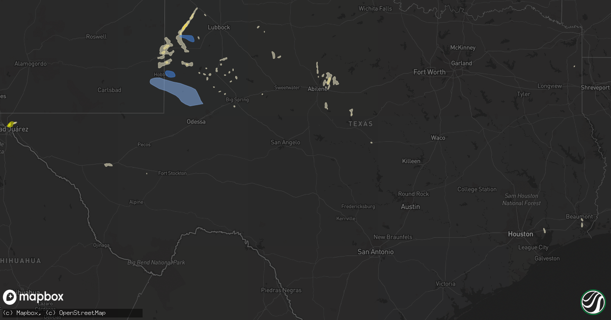
Hail Map in Texas on June 2, 2022
Get this storm
June 2 map
$229
one time, instant access
Download today. No call, no setup
Keep the $229
Bought the map and want the full workflow? Apply the entire $229 to a subscription within 7 days. None of it is wasted.
Every map, not just this one
This buys you this map. Subscription and you get every map we run, in the markets you choose from a few cities to whole states to nationwide. Plus real-time alerts the moment a storm fires.
Contact data
Name, contact info, occupancy, even credit band for addresses in the footprint. You go from where it hit to who to call.
Become the source they trust
Unlimited branding weather history reports on demand. You already have the documented answer ready for the property owner, and you are the one who showed up with it.
Property data and RoofTrace estimates
Pull up any address you have got, its value and the exact code rules for that jurisdiction, straight from One Click Code. Then RoofTrace estimates the squares, pitch, and roof value, priced the way you price.
Storm reports in Texas
Texas
| Date | Description |
|---|---|
| 06/02/20227:11 AM CDT | At 1210 AM CDT, a severe thunderstorm was located 9 miles southeast of Fort Griffin, moving south at 30 mph. HAZARD...70 mph wind gusts and quarter size hail. SOURCE...Radar indicated. IMPACT...Hail damage to vehicles is expected. Expect considerable tree damage. Wind damage is also likely to mobile homes, roofs, and outbuildings. This severe thunderstorm will be near... Ibex around 1230 AM CDT. Moran around 1245 AM CDT.Other locations impacted by this severe thunderstorm include MccartyLake, Us-180 Near The Shackelford-Stephens County Line and Us-283 Near The Callahan-Shackelford County Line. |
| 06/02/20227:07 AM CDT | At 1206 AM CDT, a severe thunderstorm was located 10 miles northwest of Breckenridge, moving south at 20 mph. HAZARD...60 mph wind gusts and quarter size hail. SOURCE...Radar indicated. IMPACT...Hail damage to vehicles is expected. Expect wind damage to roofs, siding, and trees. Locations impacted include... Hubbard Creek Reservoir and Breckenridge. |
| 06/02/20226:11 AM CDT | At 1111 PM MDT, a severe thunderstorm was located 23 miles west of Monument, or 28 miles west of Eunice, moving east at 20 mph. HAZARD...60 mph wind gusts and quarter size hail. SOURCE...Radar indicated. IMPACT...Hail damage to vehicles is expected. Expect wind damage to roofs, siding, and trees. Locations impacted include... Hobbs, Eunice, Jal, Jal Airport, Monument, Nadine, Eunice Airport, Bennett, Lea County Regional Airport and Oil Center. |
| 06/02/20225:15 AM CDT | At 1015 PM MDT, a severe thunderstorm was located 14 miles north of Dell City, moving southeast at 45 mph. HAZARD...60 mph wind gusts and quarter size hail. SOURCE...Radar indicated. IMPACT...Hail damage to vehicles is expected. Expect wind damage to roofs, siding, and trees. Locations impacted include... Dell City, Guadalupe Mountains National Park, Crow Flats, Far Western Portions of Guadalupe Mountains National Park and Gypsum Dunes at Guadalupe National Park. |
| 06/02/20224:45 AM CDT | At 944 PM MDT, a severe thunderstorm was located 29 miles northwest of Dell City, moving southeast at 25 mph. HAZARD...60 mph wind gusts and half dollar size hail. SOURCE...Radar indicated. IMPACT...Hail damage to vehicles is expected. Expect wind damage to roofs, siding, and trees. Locations impacted include... Cornudas Mountains. |
| 06/02/20224:44 AM CDT | At 943 PM CDT, a severe thunderstorm was located near Oyster Creek, or 8 miles north of Surfside Beach, moving south at 20 mph. HAZARD...60 mph wind gusts. SOURCE...Radar indicated. IMPACT...Expect damage to roofs, siding, and trees. Locations impacted include... Eastern Freeport, Surfside Beach and Oyster Creek. |
| 06/02/20222:27 AM CDT | At 727 PM CDT, a severe thunderstorm was located near Plateau, or 16 miles west of Kent, moving east at 25 mph. HAZARD...60 mph wind gusts and quarter size hail. SOURCE...Radar indicated. IMPACT...Hail damage to vehicles is expected. Expect wind damage to roofs, siding, and trees. Locations impacted include... Kent and Plateau. This includes the following highways... Interstate 10 between mile markers 157 and 190. Interstate 20 between mile markers 0 and 3. |
| 06/02/20222:22 AM CDT | At 722 PM CDT, a severe thunderstorm was located near Port Acres, or near Port Arthur, moving south at 20 mph. HAZARD...70 mph wind gusts and quarter size hail. SOURCE...Radar indicated. IMPACT...Hail damage to vehicles is expected. Expect considerable tree damage. Wind damage is also likely to mobile homes, roofs, and outbuildings. Locations impacted include... Port Arthur, Groves, Port Neches, Sabine Pass, La Belle, Port Acres and Sea Rim State Park. |
| 06/02/20221:20 AM CDT | At 620 PM MDT, a severe thunderstorm was located near East El Paso, moving northeast at 15 mph. HAZARD...60 mph wind gusts and quarter size hail. SOURCE...Radar indicated. IMPACT...Hail damage to vehicles is expected. Expect wind damage to roofs, siding, and trees. Locations impacted include... East El Paso, Central El Paso, Far East El Paso, Mission Valley, Hueco Tanks, Fort Bliss, Homestead Meadows, Montana Vista, Butterfield, Hueco Mountain Estates, Fort Bliss Northeast and Biggs Field.This includes Interstate 10 in Texas between mile markers 24 and 32. |
| 06/02/202212:55 AM CDT | Measured by the west texas mesonet. |
| 06/01/20228:05 PM CDT | At 104 AM CDT, a severe thunderstorm was located near Gunsight, or 10 miles south of Breckenridge, moving east at 30 mph. HAZARD...60 mph wind gusts. SOURCE...Radar indicated. IMPACT...Expect damage to roofs, siding, and trees. Locations impacted include... Harpersville and Highway 183 south of Breckenridge. |
| 06/01/20227:34 PM CDT | A local report indicates 1.00 inch wind near 2 SE FORT BLISS |
| 06/01/20227:08 PM CDT | Kbpt site recorded the wind speed. |
All States Impacted by Hail Map on June 2, 2022
Cities Impacted by Hail Map on June 2, 2022
- Manassas, VA
- Gainesville, VA
- Catharpin, VA
- Seaford, DE
- Morristown, TN
- Raven, VA
- Chatham, VA
- Saint Paul, VA
- Claiborne, MD
- Saint Michaels, MD
- Mcdaniel, MD
- Woodford, VA
- Ruther Glen, VA
- Beaverdam, VA
- Decatur, AL
- Fredericksburg, VA
- Stafford, VA
- Charlottesville, VA
- Kingsport, TN
- Dalton, GA
- Sugar Valley, GA
- La Fayette, GA
- Summerville, GA
- Cherokee, AL
- Powhatan, VA
- Cumberland, VA
- Spur, TX
- El Paso, TX
- Lovington, NM
- Plains, TX
- Denver City, TX
- Tatum, NM
- Pinon, NM
- Weed, NM
- Gail, TX
- Paeonian Springs, VA
- Round Hill, VA
- Hamilton, VA
- Leesburg, VA
- Sterling, VA
- Gaithersburg, MD
- Potomac, MD
- Germantown, MD
- Poolesville, MD
- Dickerson, MD
- Ashburn, VA
- Great Falls, VA
- Rockville, MD
- Purcellville, VA
- Vienna, VA
- Hughesville, MD
- Jefferson, TX
- Harvest, AL
- Lamesa, TX
- Clyde, TX
- Davidsonville, MD
- Edgewater, MD
- Jumping Branch, WV
- Forked River, NJ
- Pemberton, NJ
- Browns Mills, NJ
- Manchester Township, NJ
- Vincentown, NJ
- Columbia, VA
- Suitland, MD
- Andrews Air Force Base, MD
- Temple Hills, MD
- Calhoun, TN
- Riceville, TN
- Brandon, MS
- Prospect, VA
- Dillwyn, VA
- Farmville, VA
- Appomattox, VA
- Pamplin, VA
- Hobbs, NM
- Seminole, TX
- Aliceville, AL
- Cloudcroft, NM
- Vernon, AL
- Linkwood, MD
- Chesapeake Beach, MD
- Vienna, MD
- Huntingtown, MD
- Woolford, MD
- Sunderland, MD
- Delmar, MD
- Prince Frederick, MD
- Trappe, MD
- Upper Marlboro, MD
- Cambridge, MD
- Laurel, DE
- Delmar, DE
- Rhodesdale, MD
- East New Market, MD
- Owings, MD
- Brandywine, MD
- Mardela Springs, MD
- Capitan, NM
- Roswell, NM
- Afton, VA
- North Garden, VA
- Greenwood, VA
- Poquoson, VA
- Dendron, VA
- Delhi, LA
- Tallulah, LA
- Easton, MD
- Fairfax Station, VA
- Fairfax, VA
- Clifton, VA
- Centreville, VA
- Bel Alton, MD
- Mechanicsville, MD
- La Plata, MD
- Charlotte Hall, MD
- Winchester, TN
- Sewanee, TN
- Belvidere, TN
- Sherwood, TN
- Decatur, TN
- Athens, GA
- Preston, MD
- Morton, TX
- Tokio, TX
- Brownfield, TX
- Levelland, TX
- Littlefield, TX
- Whiteface, TX
- Unionville, VA
- East Flat Rock, NC
- Flat Rock, NC
- Bowie, MD
- Hillsville, VA
- Laurel Fork, VA
- Tarzan, TX
- Ooltewah, TN
- Bridgeville, DE
- Federalsburg, MD
- Dunkirk, MD
- Lothian, MD
- Friendship, MD
- Tracys Landing, MD
- Deale, MD
- Gretna, VA
- Mayking, KY
- Jenkins, KY
- Whitesburg, KY
- Pound, VA
- Morganton, NC
- Oxford, MD
- Hurlock, MD
- Cape Charles, VA
- Rutledge, TN
- Leicester, NC
- Spout Spring, VA
- Concord, VA
- Cartersville, VA
- Rising Star, TX
- May, TX
- Okatie, SC
- Ridgeland, SC
- Coeburn, VA
- Wise, VA
- Silver Spring, MD
- Ackerly, TX
- Rome, GA
- Silver Creek, GA
- Weaverville, NC
- Pollock, LA
- Dry Prong, LA
- Bentley, LA
- Snyder, TX
- Colorado City, TX
- Glenmora, LA
- Fort Stockton, TX
- Moseley, VA
- Amelia Court House, VA
- South Hill, VA
- Philadelphia, TN
- Athens, TN
- Sweetwater, TN
- Niota, TN
- Pasadena, MD
- Arnold, MD
- Gibson Island, MD
- Waverly, VA
- Spring Grove, VA
- Taft, TN
- Fayetteville, TN
- Ardmore, TN
- Big Spring, TX
- Port Republic, MD
- Buena Vista, VA
- Annapolis, MD
- Severna Park, MD
- Crofton, MD
- Crownsville, MD
- Odenton, MD
- Laurel, MD
- Gambrills, MD
- Glenn Dale, MD
- Abingdon, VA
- Meadowview, VA
- Westfield, NC
- King, NC
- Germanton, NC
- Walnut Cove, NC
- Danbury, NC
- Talbott, TN
- Jefferson City, TN
- New Market, TN
- Blairs, VA
- Fancy Gap, VA
- Jal, NM
- Andalusia, AL
- Meadows Of Dan, VA
- Aldie, VA
- Middleburg, VA
- Chantilly, VA
- Disputanta, VA
- Madisonville, TN
- Jasper, AL
- Arley, AL
- Double Springs, AL
- Jayton, TX
- Alamogordo, NM
- Meadow, TX
- Seagraves, TX
- Pioneer, LA
- Chatsworth, GA
- Glen Echo, MD
- Cabin John, MD
- Bethesda, MD
- McLean, VA
- Takoma Park, MD
- Chevy Chase, MD
- Washington, DC
- Dandridge, TN
- Nebo, NC
- Greenwood, DE
- Manchester, GA
- Woodbury, GA
- Lena, LA
- Colfax, LA
- Boyce, LA
- Loop, TX
- Lenorah, TX
- New Iberia, LA
- Bunkie, LA
- Morrow, LA
- Sulligent, AL
- Lecompte, LA
- Alexandria, LA
- Pineville, LA
- Fort Bliss, TX
- Oakdale, LA
- Hendersonville, NC
- Zirconia, NC
- Louin, MS
- Forest Hill, LA
- Trout, LA
- Georgetown, LA
- Mountainair, NM
- Saluda, NC
- Plains, GA
- Marksville, LA
- Deville, LA
- Center Point, LA
- Effie, LA
- Mamou, LA
- Baytown, TX
- Albany, TX
- Willard, NM
- Socorro, NM
- Greenwood Springs, MS
- Beaverton, AL
- Winfield, AL
- Guin, AL
- Gattman, MS
- Caledonia, MS
- Fayette, AL
- Arnaudville, LA
- Beaumont, TX
- Port Arthur, TX
- Plaucheville, LA
- Evergreen, LA
- Pelahatchie, MS
- Pulaski, MS
- Morton, MS
- Tahoka, TX
- Odonnell, TX
- Repton, AL
- Frisco City, AL
- Forest, MS
- Jasper, TN
- Sequatchie, TN
- South Pittsburg, TN
- Clayton, AL
- Abilene, TX
- Van Horn, TX
- Woodworth, LA
- Ville Platte, LA
- Asheville, NC
- Goldthwaite, TX
- Dugspur, VA
- Conway, SC
- Anton, TX
- Petersburg, TN
- Stanton, TX
- Hawley, TX
- Port Gibson, MS
- Pattison, MS
- Lueders, TX
- Monroe, LA
- Monroeville, AL
- Welch, TX
- Truth Or Consequences, NM
- Dickens, TX
- Nederland, TX
- Moran, TX
- Stringer, MS
- Anson, TX
- Stamford, TX
- Avoca, TX
- Natchitoches, LA
- Delcambre, LA
- Erath, LA
- Maidens, VA
- State Farm, VA
- Goochland, VA
- Crozier, VA
- Bushwood, MD
- Abell, MD
- Great Mills, MD
- Patuxent River, MD
- Coltons Point, MD
- Lexington Park, MD
- Callaway, MD
- Hollywood, MD
- California, MD
- Leonardtown, MD
- Avenue, MD
- Park Hall, MD
- White Pine, TN
- Saint Leonard, MD
- Claunch, NM
- Eunice, NM
- Monument, NM
- Midland, TX
- Andrews, TX
- Jonesville, LA


