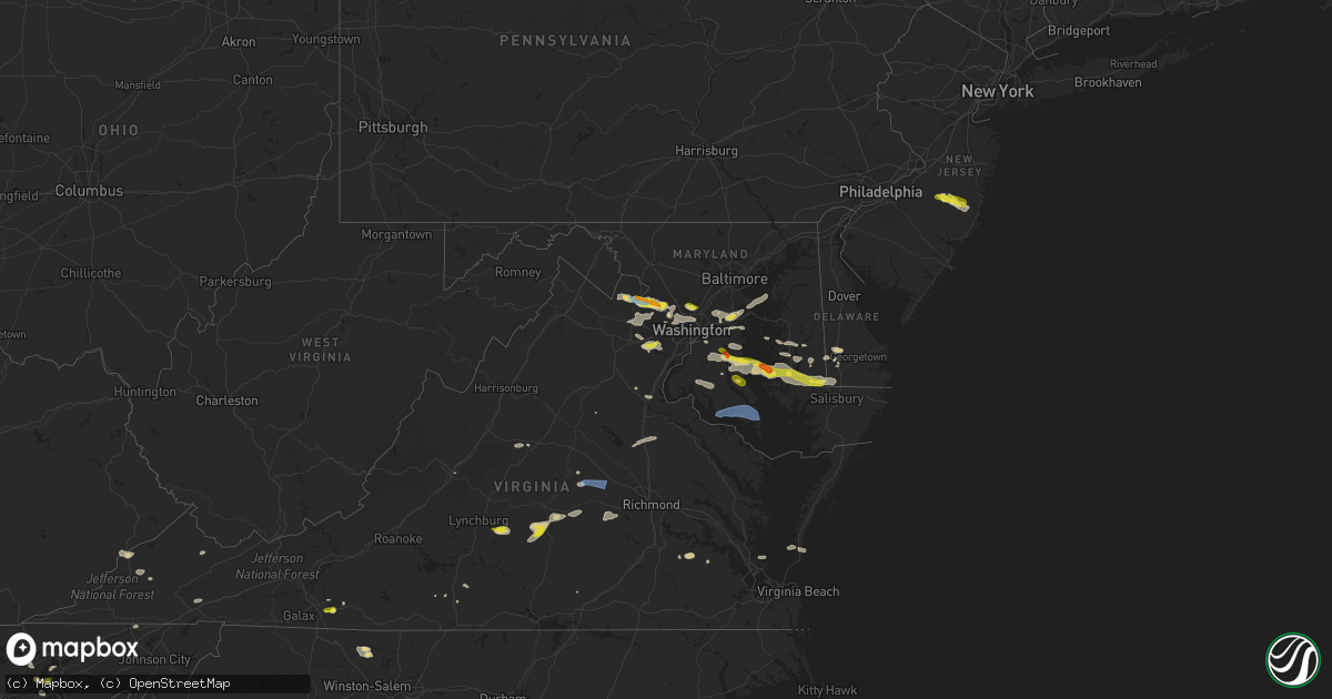
Hail Map in Maryland on June 2, 2022
Get this storm
June 2 map
$229
one time, instant access
Download today. No call, no setup
Keep the $229
Bought the map and want the full workflow? Apply the entire $229 to a subscription within 7 days. None of it is wasted.
Every map, not just this one
This buys you this map. Subscription and you get every map we run, in the markets you choose from a few cities to whole states to nationwide. Plus real-time alerts the moment a storm fires.
Contact data
Name, contact info, occupancy, even credit band for addresses in the footprint. You go from where it hit to who to call.
Become the source they trust
Unlimited branding weather history reports on demand. You already have the documented answer ready for the property owner, and you are the one who showed up with it.
Property data and RoofTrace estimates
Pull up any address you have got, its value and the exact code rules for that jurisdiction, straight from One Click Code. Then RoofTrace estimates the squares, pitch, and roof value, priced the way you price.
Storm reports in Maryland
Maryland
| Date | Description |
|---|---|
| 06/02/20226:45 PM CDT | Large tree limb down on revells neck road near route 13. Time estimated. |
| 06/02/20226:35 PM CDT | Tree down on stewart neck road. Time estimated from radar. |
| 06/02/20226:28 PM CDT | A local report indicates 67 MPH wind near 8 E SMITH ISLAND |
| 06/02/20226:25 PM CDT | Corrects previous tstm wnd dmg report from 1 ese ironshire. Power lines down near the intersection of orchard road and ocean highway. Time estimated. |
| 06/02/20225:54 PM CDT | Measured 50 knot thunderstorm wind gust at ksby. |
| 06/02/20225:50 PM CDT | Trees downed along us 13 between jones rd and ocean hwy. |
| 06/02/20225:45 PM CDT | Trees down and power outages in and around salisbury. Time estimated. |
| 06/02/20225:24 PM CDT | Multiple trees reported down in the area of bashford lane. Time estimated by radar. |
| 06/02/20225:24 PM CDT | Tree damage reported at the 24600 block of maddox road. Time estimated by radar. |
| 06/02/20225:24 PM CDT | Barn damaged |
| 06/02/20224:59 PM CDT | A local report indicates 1.00 inch wind near 3 SSE HUDSON |
| 06/02/20224:58 PM CDT | Us-50 closed at rabbit hill rd due to downed trees and/or wires. Time estimated from radar. |
| 06/02/20224:50 PM CDT | Trees down on hills point road. Time estimated from radar. |
| 06/02/20224:45 PM CDT | Large tree limb... Approximately 6 inches in diameter... Downed. |
| 06/02/20224:37 PM CDT | Pictures sent in via email. Multiple large trees downed in yard. One tree down on a car. Time estimated via radar. |
| 06/02/20224:35 PM CDT | Md-578 closed in both directions at newton rd due to trees and/or wires down. Time estimated from radar. |
| 06/02/20223:56 PM CDT | One tree uprooted... One tree snapped and wind damage to crops at a farm along with marble size hail |
| 06/02/20223:47 PM CDT | Tree down on lanham severn road near woodstream drive |
| 06/02/20223:28 PM CDT | Tree down on the 8000 block of flower avenue |
| 06/02/20223:24 PM CDT | Powerline wires and tree down on the 4700 block of chevy chase blvd |
| 06/02/20223:24 PM CDT | Tree down and powerline wires down at brookville road near taylor street |
| 06/02/20223:22 PM CDT | Tree down and powerline wires down near the intersection of md-186 and brookville road near taylor street |
| 06/02/20223:17 PM CDT | Powerline wires down on the 10000 block of nolcrest drive |
| 06/02/20223:17 PM CDT | Powerline wires down on the 7000 block of wilson lane |
| 06/02/20223:10 PM CDT | Powerline wires down on the 8900 block of persimmon tree road |
| 06/02/20223:10 PM CDT | Powerline wires down near the 1200 block of downs drive |
| 06/02/20223:09 PM CDT | Powerline wires down near the intersection of falls road & democracy blvd |
| 06/02/20223:01 PM CDT | A local report indicates 1.00 inch wind near 3 W NORTH POTOMAC |
| 06/02/20222:49 PM CDT | A local report indicates 1.00 inch wind near 4 SW POOLESVILLE |
| 06/02/20222:11 PM CDT | A local report indicates 1.00 inch wind near 1 SSE CROFTON |
| 06/02/20222:27 AM CDT | At 727 PM EDT, a severe thunderstorm was located near Millville, or 17 miles north of Ocean City, moving east at 40 mph. HAZARD...70 mph wind gusts and penny size hail. SOURCE...Radar indicated. IMPACT...Expect considerable tree damage. Damage is likely to mobile homes, roofs, and outbuildings. Locations impacted include... Selbyville, Millville, Henlopen Acres, Long Neck, Ocean View, Frankford, South Bethany and Dewey Beach. |
| 06/02/20221:44 AM CDT | At 644 PM EDT, severe thunderstorms were located along a line extending from near Chesapeake Ranch Estates to near Hague, moving east at 45 mph. HAZARD...60 mph wind gusts. SOURCE...Radar indicated. IMPACT...Damaging winds will cause some trees and large branches to fall. This could injure those outdoors, as well as damage homes and vehicles. Roadways may become blocked by downed trees. Localized power outages are possible. Unsecured light objects may become projectiles. Locations impacted include... Lexington Park, Leonardtown, Piney Point, Tall Timbers, Saint Inigoes Creek, Saint Marys City, Saint George Island, Town Creek, Saint Marys River, White Point Beach, California, Patuxent River Naval Air Station, Drum Point, Valley Lee, Scotland, Great Mills, Drayden, Saint Inigoes, Park Hall and Dameron. |
| 06/02/20221:41 AM CDT | At 641 PM EDT, severe thunderstorms were located along a line extending from near Coles Point to Farnham to Jamaica, moving east at 45 mph. HAZARD...60 mph wind gusts and penny size hail. SOURCE...Radar indicated. IMPACT...Expect damage to trees and powerlines. Severe thunderstorms will be near... Callao, Robley and Kinsale around 645 PM EDT. Heathsville around 650 PM EDT. Lancaster and Lewisetta around 655 PM EDT. Kilmarnock around 700 PM EDT. Wicomico Church around 705 PM EDT. Fair Port around 710 PM EDT.Other locations impacted by these severe thunderstorms includeByrdton, Lottsburg, Threeway, Avalon, Brook Vale, Bertrand,Reedville, Belle Isle State Park, Millenbeck and Westmoreland. |
| 06/02/20221:04 AM CDT | At 604 PM EDT, a severe thunderstorm was located over Golden Beach, or near Hallowing Point, moving east at 35 mph. HAZARD...60 mph wind gusts and quarter size hail. SOURCE...Radar indicated. IMPACT...Damaging winds will cause some trees and large branches to fall. This could injure those outdoors, as well as damage homes and vehicles. Roadways may become blocked by downed trees. Localized power outages are possible. Unsecured light objects may become projectiles. Locations impacted include... Chesapeake Ranch Estates, Prince Frederick, Greenwell State Park, Saint Leonard Creek, Cuckold Creek, Town Creek, Sheridan Point, Flag Harbor, Calvert Cliffs, California, Lusby, Saint Leonard, Hollywood, Drum Point, Long Beach, Calvert Beach, Port Republic, Morganza, Dowell and Hillville. |
| 06/02/20221:04 AM CDT | At 604 PM EDT, severe thunderstorms were located along a line extending from King George to near Loretto to near Aylett, moving east at 45 mph. HAZARD...60 mph wind gusts and penny size hail. SOURCE...Radar indicated. IMPACT...Expect damage to trees and powerlines. Severe thunderstorms will be near... Champlain, Loretto and Leedstown around 610 PM EDT. King William around 615 PM EDT. Colonial Beach, Newland, Stevensville and Millers Tavern around 620 PM EDT. Montross and King And Queen Court House around 625 PM EDT. Warsaw, Center Cross and Dunnsville around 630 PM EDT. Hague around 635 PM EDT. Jamaica, Kinsale, Coles Point, Sharps and Church View around 640 PM EDT. Robley, Morattico and Lewisetta around 645 PM EDT.Other locations impacted by these severe thunderstorms includeBeazley, Currioman Landing, Lottsburg, Threeway, Cohoke, Belle IsleState Park, Rose Garden, Biscoe, Lyells and Crouch. |
| 06/02/202212:43 AM CDT | At 543 PM EDT, severe thunderstorms were located along a line extending from near La Plata to Fairview Beach, moving east at 40 mph. HAZARD...60 mph wind gusts. SOURCE...Radar indicated. IMPACT...Damaging winds will cause some trees and large branches to fall. This could injure those outdoors, as well as damage homes and vehicles. Roadways may become blocked by downed trees. Localized power outages are possible. Unsecured light objects may become projectiles. Locations impacted include... Waldorf, La Plata, King George, Dahlgren, Prince Frederick, Nanjemoy Creek, Sheridan Point, Popes Creek, Hallowing Point, Port Tobacco River, Wicomico River, Golden Beach, Wicomico, Hughesville, Mechanicsville, Charlotte Hall, Cobb Island, Aquasco, Bryantown and Pomfret. |
| 06/02/202212:14 AM CDT | At 514 PM EDT, severe thunderstorms were located along a line extending from near Stafford to 7 miles north of Mineral, moving east at 30 mph. HAZARD...60 mph wind gusts. SOURCE...Radar indicated. IMPACT...Damaging winds will cause some trees and large branches to fall. This could injure those outdoors, as well as damage homes and vehicles. Roadways may become blocked by downed trees. Localized power outages are possible. Unsecured light objects may become projectiles. Locations impacted include... Stafford, Fredericksburg, King George, Fairview Beach, Potomac Creek, Nanjemoy Creek, Aquia Creek, Massaponax, Spotsylvania, Falmouth, Passapatanzy, Stones Corner, Mine Run, Roseville, Garrisonville, Ironsides, Locust Grove, Snell, Ramoth and Partlow. |
| 06/01/202211:45 PM CDT | At 445 PM EDT, a severe thunderstorm was located over Marlton, or near Clinton, moving east at 30 mph. HAZARD...60 mph wind gusts and quarter size hail. SOURCE...Radar indicated. IMPACT...Damaging winds will cause some trees and large branches to fall. This could injure those outdoors, as well as damage homes and vehicles. Roadways may become blocked by downed trees. Localized power outages are possible. Unsecured light objects may become projectiles. Locations impacted include... Clinton, Chesapeake Beach, Deale, Upper Marlboro, Breezy Point, Andrews Air Force Base, Rosaryville, Marlton, Dunkirk, Brandywine, Huntingtown, Owings, Baden, Aquasco, Friendship, Lower Marlboro, Tracys Landing, Sunderland, Cheltenham and Mount Harmony. |
| 06/01/202211:43 PM CDT | At 443 PM EDT, a severe thunderstorm was located near Crofton, moving east at 30 mph. HAZARD...60 mph wind gusts and quarter size hail. SOURCE...Radar indicated. IMPACT...Damaging winds will cause some trees and large branches to fall. This could injure those outdoors, as well as damage homes and vehicles. Roadways may become blocked by downed trees. Localized power outages are possible. Unsecured light objects may become projectiles. Locations impacted include... Bowie, Severn, Annapolis, College Park, Crofton, Greenbelt, Beltsville, Mayo, Naval Academy, Magothy River, Dobbins Island, Severn River, Pinehurst, Gibson Island, Sillery Bay, Bodkin Point, Glen Burnie, Severna Park, Odenton and Laurel. |
| 06/01/202211:02 PM CDT | At 402 PM EDT, a severe thunderstorm was located over Fairland, or near Beltsville, moving east at 30 mph. HAZARD...60 mph wind gusts and quarter size hail. SOURCE...Radar indicated. IMPACT...Damaging winds will cause some trees and large branches to fall. This could injure those outdoors, as well as damage homes and vehicles. Roadways may become blocked by downed trees. Localized power outages are possible. Unsecured light objects may become projectiles. Locations impacted include... Columbia, Bowie, Severn, Olney, College Park, Crofton, Greenbelt, Beltsville, Elkridge, Baltimore-Washington Airport, Glen Burnie, Aspen Hill, Severna Park, Odenton, Laurel, Fairland, White Oak, Ferndale, Adelphi and Colesville. |
| 06/01/202210:57 PM CDT | At 357 PM EDT, a severe thunderstorm was located near Rock Hall, or near Bodkin Point, moving northeast at 25 mph. HAZARD...60 mph wind gusts and half dollar size hail. SOURCE...Radar indicated. IMPACT...Minor damage to vehicles is possible. Wind damage to roofs, siding, trees, and power lines is possible. Locations impacted include... Chestertown, Rock Hall, Church Hill, Sudlersville, Betterton, Old Town, Langford, Newtown, Starkey Corner, Morgnec, Crumpton, Kennedyville, Barclay and Kingstown. |
| 06/01/202210:54 PM CDT | At 354 PM EDT, a severe thunderstorm was located over Talbot, or 12 miles east of South River, moving east at 20 mph. HAZARD...60 mph wind gusts and quarter size hail. SOURCE...Radar indicated. IMPACT...Minor damage to vehicles is possible. Wind damage to roofs, siding, trees, and power lines is possible. Locations impacted include... Easton, Talbot, Romancoke, Oakland, Ridgely, St. Michaels, Queen Anne, Tanyard, Harmony, Grasonville, Starr, Skipton, Copperville, Jumptown, Matthews, Wye Mills, Griffin, Cordova and Hillsboro. |
| 06/01/202210:27 PM CDT | At 327 PM EDT, a severe thunderstorm was located over Arnold, or near Naval Academy, moving northeast at 20 mph. HAZARD...60 mph wind gusts and quarter size hail. SOURCE...Radar indicated. IMPACT...Damaging winds will cause some trees and large branches to fall. This could injure those outdoors, as well as damage homes and vehicles. Roadways may become blocked by downed trees. Localized power outages are possible. Unsecured light objects may become projectiles. Locations impacted include... Pinehurst, Dobbins Island, Gibson Island, Sillery Bay, Bodkin Point, Severna Park, Pasadena, Arnold, Lake Shore, Cape St. Claire, Herald Harbor, Crownsville, Chelsea Beach and Belvedere Heights. |
| 06/01/202210:25 PM CDT | At 325 PM EDT, a severe thunderstorm was located over Purcellville, or 7 miles northwest of Leesburg, moving east at 30 mph. HAZARD...60 mph wind gusts. SOURCE...Radar indicated. IMPACT...Damaging winds will cause some trees and large branches to fall. This could injure those outdoors, as well as damage homes and vehicles. Roadways may become blocked by downed trees. Localized power outages are possible. Unsecured light objects may become projectiles. Locations impacted include... Leesburg, Lansdowne, Lowes Island, Poolesville, Ashburn, Countryside, Purcellville, Round Hill, Belmont, Hamilton, Barnesville, Hillsboro, Paeonian Springs, Waterford, Lucketts, Dickerson, Beallsville, Dawsonville, Lincoln and Hughesville. |
| 06/01/202210:22 PM CDT | At 321 PM EDT, a severe thunderstorm was located over Arnold, or near Naval Academy, moving northeast at 25 mph. HAZARD...60 mph wind gusts and quarter size hail. SOURCE...Radar indicated. IMPACT...Minor damage to vehicles is possible. Wind damage to roofs, siding, trees, and power lines is possible. Locations impacted include... Centerville, Centreville, Rock Hall, Chester, Overton, Old Town, Grasonville, Stevensville, Langford, Wye Mills, Queenstown and Stevensville South. |
| 06/01/202210:07 PM CDT | At 306 PM EDT, a severe thunderstorm was located near Parole, or near Crofton, moving east at 25 mph. HAZARD...60 mph wind gusts. SOURCE...Radar indicated. IMPACT...Damaging winds will cause some trees and large branches to fall. This could injure those outdoors, as well as damage homes and vehicles. Roadways may become blocked by downed trees. Localized power outages are possible. Unsecured light objects may become projectiles. Locations impacted include... Annapolis, Crofton, Mayo, Naval Academy, Magothy River, Severn River, South River, Arnold, Parole, Londontowne, Edgewater, Cape St. Claire, Riva, Crownsville, Highland Beach, Hillsmere Shores, Sherwood Forest, Davidsonville, Navy-Marine Corps Stadium and Eastport. |
| 06/01/20227:25 PM CDT | Power lines down near the intersection of orchard road and ocean highway. Time estimated. |
All States Impacted by Hail Map on June 2, 2022
Cities Impacted by Hail Map on June 2, 2022
- Manassas, VA
- Gainesville, VA
- Catharpin, VA
- Seaford, DE
- Morristown, TN
- Raven, VA
- Chatham, VA
- Saint Paul, VA
- Claiborne, MD
- Saint Michaels, MD
- Mcdaniel, MD
- Woodford, VA
- Ruther Glen, VA
- Beaverdam, VA
- Decatur, AL
- Fredericksburg, VA
- Stafford, VA
- Charlottesville, VA
- Kingsport, TN
- Dalton, GA
- Sugar Valley, GA
- La Fayette, GA
- Summerville, GA
- Cherokee, AL
- Powhatan, VA
- Cumberland, VA
- Spur, TX
- El Paso, TX
- Lovington, NM
- Plains, TX
- Denver City, TX
- Tatum, NM
- Pinon, NM
- Weed, NM
- Gail, TX
- Paeonian Springs, VA
- Round Hill, VA
- Hamilton, VA
- Leesburg, VA
- Sterling, VA
- Gaithersburg, MD
- Potomac, MD
- Germantown, MD
- Poolesville, MD
- Dickerson, MD
- Ashburn, VA
- Great Falls, VA
- Rockville, MD
- Purcellville, VA
- Vienna, VA
- Hughesville, MD
- Jefferson, TX
- Harvest, AL
- Lamesa, TX
- Clyde, TX
- Davidsonville, MD
- Edgewater, MD
- Jumping Branch, WV
- Forked River, NJ
- Pemberton, NJ
- Browns Mills, NJ
- Manchester Township, NJ
- Vincentown, NJ
- Columbia, VA
- Suitland, MD
- Andrews Air Force Base, MD
- Temple Hills, MD
- Calhoun, TN
- Riceville, TN
- Brandon, MS
- Prospect, VA
- Dillwyn, VA
- Farmville, VA
- Appomattox, VA
- Pamplin, VA
- Hobbs, NM
- Seminole, TX
- Aliceville, AL
- Cloudcroft, NM
- Vernon, AL
- Linkwood, MD
- Chesapeake Beach, MD
- Vienna, MD
- Huntingtown, MD
- Woolford, MD
- Sunderland, MD
- Delmar, MD
- Prince Frederick, MD
- Trappe, MD
- Upper Marlboro, MD
- Cambridge, MD
- Laurel, DE
- Delmar, DE
- Rhodesdale, MD
- East New Market, MD
- Owings, MD
- Brandywine, MD
- Mardela Springs, MD
- Capitan, NM
- Roswell, NM
- Afton, VA
- North Garden, VA
- Greenwood, VA
- Poquoson, VA
- Dendron, VA
- Delhi, LA
- Tallulah, LA
- Easton, MD
- Fairfax Station, VA
- Fairfax, VA
- Clifton, VA
- Centreville, VA
- Bel Alton, MD
- Mechanicsville, MD
- La Plata, MD
- Charlotte Hall, MD
- Winchester, TN
- Sewanee, TN
- Belvidere, TN
- Sherwood, TN
- Decatur, TN
- Athens, GA
- Preston, MD
- Morton, TX
- Tokio, TX
- Brownfield, TX
- Levelland, TX
- Littlefield, TX
- Whiteface, TX
- Unionville, VA
- East Flat Rock, NC
- Flat Rock, NC
- Bowie, MD
- Hillsville, VA
- Laurel Fork, VA
- Tarzan, TX
- Ooltewah, TN
- Bridgeville, DE
- Federalsburg, MD
- Dunkirk, MD
- Lothian, MD
- Friendship, MD
- Tracys Landing, MD
- Deale, MD
- Gretna, VA
- Mayking, KY
- Jenkins, KY
- Whitesburg, KY
- Pound, VA
- Morganton, NC
- Oxford, MD
- Hurlock, MD
- Cape Charles, VA
- Rutledge, TN
- Leicester, NC
- Spout Spring, VA
- Concord, VA
- Cartersville, VA
- Rising Star, TX
- May, TX
- Okatie, SC
- Ridgeland, SC
- Coeburn, VA
- Wise, VA
- Silver Spring, MD
- Ackerly, TX
- Rome, GA
- Silver Creek, GA
- Weaverville, NC
- Pollock, LA
- Dry Prong, LA
- Bentley, LA
- Snyder, TX
- Colorado City, TX
- Glenmora, LA
- Fort Stockton, TX
- Moseley, VA
- Amelia Court House, VA
- South Hill, VA
- Philadelphia, TN
- Athens, TN
- Sweetwater, TN
- Niota, TN
- Pasadena, MD
- Arnold, MD
- Gibson Island, MD
- Waverly, VA
- Spring Grove, VA
- Taft, TN
- Fayetteville, TN
- Ardmore, TN
- Big Spring, TX
- Port Republic, MD
- Buena Vista, VA
- Annapolis, MD
- Severna Park, MD
- Crofton, MD
- Crownsville, MD
- Odenton, MD
- Laurel, MD
- Gambrills, MD
- Glenn Dale, MD
- Abingdon, VA
- Meadowview, VA
- Westfield, NC
- King, NC
- Germanton, NC
- Walnut Cove, NC
- Danbury, NC
- Talbott, TN
- Jefferson City, TN
- New Market, TN
- Blairs, VA
- Fancy Gap, VA
- Jal, NM
- Andalusia, AL
- Meadows Of Dan, VA
- Aldie, VA
- Middleburg, VA
- Chantilly, VA
- Disputanta, VA
- Madisonville, TN
- Jasper, AL
- Arley, AL
- Double Springs, AL
- Jayton, TX
- Alamogordo, NM
- Meadow, TX
- Seagraves, TX
- Pioneer, LA
- Chatsworth, GA
- Glen Echo, MD
- Cabin John, MD
- Bethesda, MD
- McLean, VA
- Takoma Park, MD
- Chevy Chase, MD
- Washington, DC
- Dandridge, TN
- Nebo, NC
- Greenwood, DE
- Manchester, GA
- Woodbury, GA
- Lena, LA
- Colfax, LA
- Boyce, LA
- Loop, TX
- Lenorah, TX
- New Iberia, LA
- Bunkie, LA
- Morrow, LA
- Sulligent, AL
- Lecompte, LA
- Alexandria, LA
- Pineville, LA
- Fort Bliss, TX
- Oakdale, LA
- Hendersonville, NC
- Zirconia, NC
- Louin, MS
- Forest Hill, LA
- Trout, LA
- Georgetown, LA
- Mountainair, NM
- Saluda, NC
- Plains, GA
- Marksville, LA
- Deville, LA
- Center Point, LA
- Effie, LA
- Mamou, LA
- Baytown, TX
- Albany, TX
- Willard, NM
- Socorro, NM
- Greenwood Springs, MS
- Beaverton, AL
- Winfield, AL
- Guin, AL
- Gattman, MS
- Caledonia, MS
- Fayette, AL
- Arnaudville, LA
- Beaumont, TX
- Port Arthur, TX
- Plaucheville, LA
- Evergreen, LA
- Pelahatchie, MS
- Pulaski, MS
- Morton, MS
- Tahoka, TX
- Odonnell, TX
- Repton, AL
- Frisco City, AL
- Forest, MS
- Jasper, TN
- Sequatchie, TN
- South Pittsburg, TN
- Clayton, AL
- Abilene, TX
- Van Horn, TX
- Woodworth, LA
- Ville Platte, LA
- Asheville, NC
- Goldthwaite, TX
- Dugspur, VA
- Conway, SC
- Anton, TX
- Petersburg, TN
- Stanton, TX
- Hawley, TX
- Port Gibson, MS
- Pattison, MS
- Lueders, TX
- Monroe, LA
- Monroeville, AL
- Welch, TX
- Truth Or Consequences, NM
- Dickens, TX
- Nederland, TX
- Moran, TX
- Stringer, MS
- Anson, TX
- Stamford, TX
- Avoca, TX
- Natchitoches, LA
- Delcambre, LA
- Erath, LA
- Maidens, VA
- State Farm, VA
- Goochland, VA
- Crozier, VA
- Bushwood, MD
- Abell, MD
- Great Mills, MD
- Patuxent River, MD
- Coltons Point, MD
- Lexington Park, MD
- Callaway, MD
- Hollywood, MD
- California, MD
- Leonardtown, MD
- Avenue, MD
- Park Hall, MD
- White Pine, TN
- Saint Leonard, MD
- Claunch, NM
- Eunice, NM
- Monument, NM
- Midland, TX
- Andrews, TX
- Jonesville, LA


