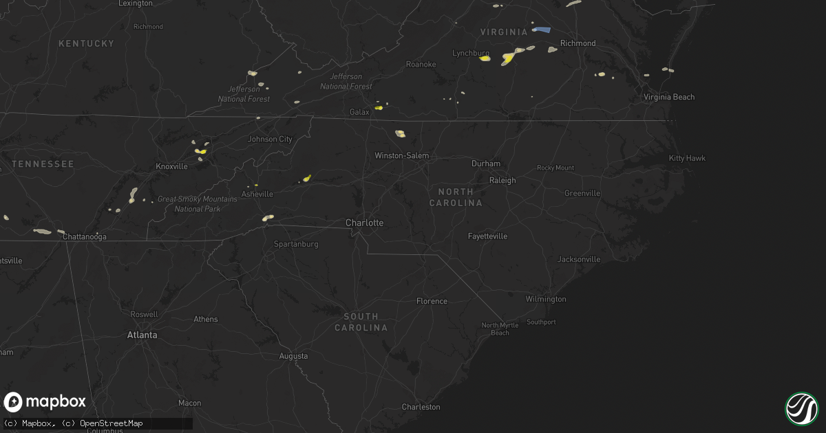
Hail Map in North Carolina on June 2, 2022
Get this storm
June 2 map
$229
one time, instant access
Download today. No call, no setup
Keep the $229
Bought the map and want the full workflow? Apply the entire $229 to a subscription within 7 days. None of it is wasted.
Every map, not just this one
This buys you this map. Subscription and you get every map we run, in the markets you choose from a few cities to whole states to nationwide. Plus real-time alerts the moment a storm fires.
Contact data
Name, contact info, occupancy, even credit band for addresses in the footprint. You go from where it hit to who to call.
Become the source they trust
Unlimited branding weather history reports on demand. You already have the documented answer ready for the property owner, and you are the one who showed up with it.
Property data and RoofTrace estimates
Pull up any address you have got, its value and the exact code rules for that jurisdiction, straight from One Click Code. Then RoofTrace estimates the squares, pitch, and roof value, priced the way you price.
Storm reports in North Carolina
North Carolina
| Date | Description |
|---|---|
| 06/02/20226:35 PM CDT | Thunderstorm winds blew a tree down across w. Aiken road. |
| 06/02/20226:34 PM CDT | Tree fell on a vehicle on sharon school rd at onramp to i-40. No injuries. |
| 06/02/20226:10 PM CDT | Power lines down on 770 close to rockingham/ stokes county line. Time estimated by radar. |
| 06/02/20226:08 PM CDT | Thunderstorm winds blew off metal roofing from a structure near the intersection of williams road and u.s. Highway 220. |
| 06/02/20225:45 PM CDT | Large oak tree down |
| 06/02/20225:42 PM CDT | About 15 trees blown down by thunderstorm winds around danbury. |
| 06/02/20225:30 PM CDT | Quarter size hail on spainhour rd in oak hill community |
| 06/02/20225:24 PM CDT | Multiple trees down on jay clark rd |
| 06/02/20225:05 PM CDT | Tree down on hauser rd. |
| 06/02/20225:05 PM CDT | Tree down on radar rd. |
| 06/02/20224:52 PM CDT | Tree down on turkey ford rd. |
| 06/02/20224:38 PM CDT | Thunderstorm winds blew down one tree along the 100 block of douglas town road. |
| 06/02/20224:19 PM CDT | Thunderstorm winds blew down one tree around a baseball park along the 100 block of roaring gap church road. |
| 06/02/20224:15 PM CDT | A few trees down around river crest pkwy |
| 06/02/20224:06 PM CDT | Thunderstorm winds blew down one tree along the 200 block of traphill benge road. |
| 06/02/20223:56 PM CDT | Tree down on boone trail near crestview ln. |
| 06/02/20223:56 PM CDT | Tree down on a powerline on prospect lane. |
| 06/02/20223:53 PM CDT | Thunderstorm winds blew down one tree along the 4900 block of hensley eller road close to the intersection with oakdale drive. |
| 06/02/20223:53 PM CDT | Thunderstorm winds blew down one tree near the intersection of green acres mill road and green acres myers street. |
| 06/02/20223:45 PM CDT | Tree fell on a car on pooveys chapel church rd. Occupants not injured. |
| 06/02/20223:45 PM CDT | Thunderstorm winds blew down one tree along the 1200 block of huffman fork road. |
| 06/02/20223:42 PM CDT | Thunderstorm winds blew down one tree at the intersection of highway 268 and tom dula road. |
| 06/02/20223:41 PM CDT | Thunderstorm winds blew down one tree along the 14700 block of highway 268. |
| 06/02/20223:41 PM CDT | Thunderstorm winds blew down one tree along the 300 block of boiling springs road. |
| 06/02/20223:40 PM CDT | Three pine trees down at powder creek apts |
| 06/02/20223:40 PM CDT | Trees down in mill spring. Time estimated from radar |
| 06/02/20223:34 PM CDT | Thunderstorm winds blew down one tree along the 2600 block of reedy branch road. |
| 06/02/20223:31 PM CDT | Trees and powerlines down on piedmont rd near nc 18 |
| 06/02/20223:29 PM CDT | Trees and powerlines down at the steele creek and daniel boone campgrounds. |
| 06/02/20223:04 PM CDT | Nickel to quarter size hail near intersection of henderson mill and piedmont roads. Time estimated from radar. |
| 06/02/20222:50 PM CDT | Thunderstorm winds blew down one tree along the 3700 block of somers road. |
| 06/02/20222:36 PM CDT | Multiple trees down in the danbury area of stokes county. |
| 06/02/20222:23 PM CDT | Thunderstorm winds blew down one tree near the 8300 block of brushy mountain road. |
| 06/02/20222:05 PM CDT | Thunderstorm winds blew down one tree at the intersection of brushy mountain road and nora oak road. |
| 06/02/20221:55 PM CDT | 1 tree down near intersection of nc hwy 704 and aubrey lawson road. |
| 06/02/20221:30 PM CDT | Wind caused collapse of walls and roof of a covered bridge. Numerous trees and powerlines down nearby. |
| 06/02/20221:05 PM CDT | Nickel to quarter size hail on weaver blvd. Reported via facebook. |
| 06/02/202212:51 PM CDT | Thunderstorm winds blew down one tree at the intersection of woodland boulevard and north brook street. |
| 06/02/20223:46 AM CDT | At 846 PM EDT, a severe thunderstorm was located near Hillsborough, moving east at 25 mph. HAZARD...60 mph wind gusts and penny size hail. SOURCE...Radar indicated. IMPACT...Expect damage to roofs, siding, and trees. Locations impacted include... Durham, Hillsborough, Lake Michie, Eno River State Park, Gorman, Rollingview Marina and Falls Lake. |
| 06/02/20222:41 AM CDT | At 740 PM EDT, a severe thunderstorm was located 11 miles northeast of Randleman, moving east at 15 mph. HAZARD...60 mph wind gusts and penny size hail. SOURCE...Radar indicated. IMPACT...Expect damage to roofs, siding, and trees. Locations impacted include... Burlington, Graham, Pleasant Garden, Liberty, Alamance, Climax, Lake Mackintosh Marina, Lake Guilford Mackintosh Marina, Forest Oaks and Snow Camp. |
| 06/02/20221:54 AM CDT | At 654 PM EDT, severe thunderstorms were located along a line extending from Prestonville to near Pine Hall, moving east at 35 mph. HAZARD...60 mph wind gusts and quarter size hail. SOURCE...Radar indicated. IMPACT...Hail damage to vehicles is expected. Expect wind damage to roofs, siding, and trees. Locations impacted include... Eden... Reidsville... Wentworth... Mayodan... Madison... Stoneville... and Mayfield. |
| 06/02/20221:36 AM CDT | At 636 PM EDT, a severe thunderstorm was located over Hanging Rock State Park, or near Danbury, moving east at 35 mph. HAZARD...60 mph wind gusts and quarter size hail. SOURCE...Radar indicated. IMPACT...Hail damage to vehicles is expected. Expect wind damage to roofs, siding, and trees. Locations impacted include... Walnut Cove... Danbury... Sandy Ridge... King... Pine Hall... Ayersville... and Hanging Rock State Park. |
| 06/02/20221:21 AM CDT | At 620 PM EDT, a severe thunderstorm was located near Morganton, moving east at 15 mph. HAZARD...60 mph wind gusts and quarter size hail. SOURCE...Radar indicated. IMPACT...Minor hail damage to vehicles is expected. Expect wind damage to trees and power lines. Locations impacted include... Lenoir, Morganton, Sawmills, Valdese, Gamewell, Hudson, Icard, Cajah's Mountain, Drexel and Connelly Springs. |
| 06/02/202212:31 AM CDT | At 531 PM EDT, a severe thunderstorm was located 9 miles east of Taylorsville, or near Love Valley, moving east at 20 mph. HAZARD...60 mph wind gusts and penny size hail. SOURCE...Radar indicated. IMPACT...Expect damage to trees and power lines. Locations impacted include... Stony Point, Harmony, Love Valley, Hiddenite, Turnersburg, Olin, Vashti, Union Grove, Cool Springs and Scotts. |
| 06/01/202211:40 PM CDT | At 439 PM EDT, severe thunderstorms were located along a line extending from near Millers Creek to near Elkville, moving east at 30 mph. HAZARD...60 mph wind gusts and quarter size hail. SOURCE...Radar indicated. IMPACT...Hail damage to vehicles is expected. Expect wind damage to roofs, siding, and trees. Locations impacted include... North Wilkesboro... Elkin... Wilkesboro... Jonesville... Ronda... Traphill... and Boomer. |
| 06/01/202211:17 PM CDT | At 417 PM EDT, a severe thunderstorm was located 10 miles north of Pickens, or near Table Rock State Park, moving east at 10 mph. HAZARD...60 mph wind gusts and penny size hail. SOURCE...Radar indicated. IMPACT...Expect damage to trees and power lines. Locations impacted include... Slater-Marietta, Table Rock State Park, Pleasant Ridge State Park, Caesars Head State Park, Jones Gap State Park, Pumpkintown, Cleveland, Furman University, Dacusville and Travelers Rest. |
| 06/01/202211:02 PM CDT | At 401 PM EDT, a severe thunderstorm was located 4 miles northwest of Morganton, moving east at 10 mph. HAZARD...60 mph wind gusts and quarter size hail. SOURCE...Radar indicated. IMPACT...Minor hail damage to vehicles is expected. Expect wind damage to trees and power lines. Locations impacted include... Lenoir, Morganton, Valdese, Gamewell, Cajah's Mountain, Drexel, Connelly Springs, Rutherford College, Lake Rhodhiss and Table Rock. |
| 06/01/202210:45 PM CDT | At 345 PM EDT, a severe thunderstorm was located 7 miles northwest of Columbus, or 5 miles north of Saluda, moving east at 10 mph. HAZARD...60 mph wind gusts and penny size hail. SOURCE...Radar indicated. IMPACT...Expect damage to trees and power lines. Locations impacted include... Columbus, Saluda, Dana, Mill Spring, Edneyville, Lake Adger, East Flat Rock and Chimney Rock State Park. |
| 06/01/202210:29 PM CDT | At 329 PM EDT, a severe thunderstorm was located near Capella, or near Francisco, moving east at 15 mph. HAZARD...60 mph wind gusts and quarter size hail. SOURCE...Radar indicated. IMPACT...Hail damage to vehicles is expected. Expect wind damage to roofs, siding, and trees. Locations impacted include... Mayodan... Madison... Walnut Cove... Danbury... Sandy Ridge... Pine Hall... and Ayersville. |
| 06/01/202210:29 PM CDT | At 329 PM EDT, a severe thunderstorm was located 11 miles northwest of Pickens, or 4 miles north of Jocassee Gorges, moving east at 10 mph. HAZARD...60 mph wind gusts and quarter size hail. SOURCE...Radar indicated. IMPACT...Minor hail damage to vehicles is expected. Expect wind damage to trees and power lines. Locations impacted include... Table Rock State Park, Jocassee Gorges, Caesars Head State Park, Sunset, Pumpkintown, Sassafras Mountain, Rocky Bottom, Lake Jocassee, Pickens and Gorges State Park. |
| 06/01/202210:24 PM CDT | At 324 PM EDT, a severe thunderstorm was located over Blairsville, moving east at 20 mph. HAZARD...60 mph wind gusts and penny size hail. SOURCE...Radar indicated. IMPACT...Expect damage to roofs, siding, and trees. Locations impacted include... Hiawassee, Blairsville, Young Harris, Brasstown Bald, Track Rock, Gumlog, Macedonia and Alexanders Mill. |
| 06/01/202210:11 PM CDT | At 311 PM EDT, a severe thunderstorm was located over Moravian Falls, or near Wilkesboro, moving east at 30 mph. HAZARD...60 mph wind gusts and quarter size hail. SOURCE...Radar indicated. IMPACT...Hail damage to vehicles is expected. Expect wind damage to roofs, siding, and trees. Locations impacted include... North Wilkesboro... Elkin... Wilkesboro... Yadkinville... Jonesville... Boonville... and Ronda. |
| 06/01/20227:36 PM CDT | Tree down on power lines near rhonda rd and oakdale dr. |
All States Impacted by Hail Map on June 2, 2022
Cities Impacted by Hail Map on June 2, 2022
- Manassas, VA
- Gainesville, VA
- Catharpin, VA
- Seaford, DE
- Morristown, TN
- Raven, VA
- Chatham, VA
- Saint Paul, VA
- Claiborne, MD
- Saint Michaels, MD
- Mcdaniel, MD
- Woodford, VA
- Ruther Glen, VA
- Beaverdam, VA
- Decatur, AL
- Fredericksburg, VA
- Stafford, VA
- Charlottesville, VA
- Kingsport, TN
- Dalton, GA
- Sugar Valley, GA
- La Fayette, GA
- Summerville, GA
- Cherokee, AL
- Powhatan, VA
- Cumberland, VA
- Spur, TX
- El Paso, TX
- Lovington, NM
- Plains, TX
- Denver City, TX
- Tatum, NM
- Pinon, NM
- Weed, NM
- Gail, TX
- Paeonian Springs, VA
- Round Hill, VA
- Hamilton, VA
- Leesburg, VA
- Sterling, VA
- Gaithersburg, MD
- Potomac, MD
- Germantown, MD
- Poolesville, MD
- Dickerson, MD
- Ashburn, VA
- Great Falls, VA
- Rockville, MD
- Purcellville, VA
- Vienna, VA
- Hughesville, MD
- Jefferson, TX
- Harvest, AL
- Lamesa, TX
- Clyde, TX
- Davidsonville, MD
- Edgewater, MD
- Jumping Branch, WV
- Forked River, NJ
- Pemberton, NJ
- Browns Mills, NJ
- Manchester Township, NJ
- Vincentown, NJ
- Columbia, VA
- Suitland, MD
- Andrews Air Force Base, MD
- Temple Hills, MD
- Calhoun, TN
- Riceville, TN
- Brandon, MS
- Prospect, VA
- Dillwyn, VA
- Farmville, VA
- Appomattox, VA
- Pamplin, VA
- Hobbs, NM
- Seminole, TX
- Aliceville, AL
- Cloudcroft, NM
- Vernon, AL
- Linkwood, MD
- Chesapeake Beach, MD
- Vienna, MD
- Huntingtown, MD
- Woolford, MD
- Sunderland, MD
- Delmar, MD
- Prince Frederick, MD
- Trappe, MD
- Upper Marlboro, MD
- Cambridge, MD
- Laurel, DE
- Delmar, DE
- Rhodesdale, MD
- East New Market, MD
- Owings, MD
- Brandywine, MD
- Mardela Springs, MD
- Capitan, NM
- Roswell, NM
- Afton, VA
- North Garden, VA
- Greenwood, VA
- Poquoson, VA
- Dendron, VA
- Delhi, LA
- Tallulah, LA
- Easton, MD
- Fairfax Station, VA
- Fairfax, VA
- Clifton, VA
- Centreville, VA
- Bel Alton, MD
- Mechanicsville, MD
- La Plata, MD
- Charlotte Hall, MD
- Winchester, TN
- Sewanee, TN
- Belvidere, TN
- Sherwood, TN
- Decatur, TN
- Athens, GA
- Preston, MD
- Morton, TX
- Tokio, TX
- Brownfield, TX
- Levelland, TX
- Littlefield, TX
- Whiteface, TX
- Unionville, VA
- East Flat Rock, NC
- Flat Rock, NC
- Bowie, MD
- Hillsville, VA
- Laurel Fork, VA
- Tarzan, TX
- Ooltewah, TN
- Bridgeville, DE
- Federalsburg, MD
- Dunkirk, MD
- Lothian, MD
- Friendship, MD
- Tracys Landing, MD
- Deale, MD
- Gretna, VA
- Mayking, KY
- Jenkins, KY
- Whitesburg, KY
- Pound, VA
- Morganton, NC
- Oxford, MD
- Hurlock, MD
- Cape Charles, VA
- Rutledge, TN
- Leicester, NC
- Spout Spring, VA
- Concord, VA
- Cartersville, VA
- Rising Star, TX
- May, TX
- Okatie, SC
- Ridgeland, SC
- Coeburn, VA
- Wise, VA
- Silver Spring, MD
- Ackerly, TX
- Rome, GA
- Silver Creek, GA
- Weaverville, NC
- Pollock, LA
- Dry Prong, LA
- Bentley, LA
- Snyder, TX
- Colorado City, TX
- Glenmora, LA
- Fort Stockton, TX
- Moseley, VA
- Amelia Court House, VA
- South Hill, VA
- Philadelphia, TN
- Athens, TN
- Sweetwater, TN
- Niota, TN
- Pasadena, MD
- Arnold, MD
- Gibson Island, MD
- Waverly, VA
- Spring Grove, VA
- Taft, TN
- Fayetteville, TN
- Ardmore, TN
- Big Spring, TX
- Port Republic, MD
- Buena Vista, VA
- Annapolis, MD
- Severna Park, MD
- Crofton, MD
- Crownsville, MD
- Odenton, MD
- Laurel, MD
- Gambrills, MD
- Glenn Dale, MD
- Abingdon, VA
- Meadowview, VA
- Westfield, NC
- King, NC
- Germanton, NC
- Walnut Cove, NC
- Danbury, NC
- Talbott, TN
- Jefferson City, TN
- New Market, TN
- Blairs, VA
- Fancy Gap, VA
- Jal, NM
- Andalusia, AL
- Meadows Of Dan, VA
- Aldie, VA
- Middleburg, VA
- Chantilly, VA
- Disputanta, VA
- Madisonville, TN
- Jasper, AL
- Arley, AL
- Double Springs, AL
- Jayton, TX
- Alamogordo, NM
- Meadow, TX
- Seagraves, TX
- Pioneer, LA
- Chatsworth, GA
- Glen Echo, MD
- Cabin John, MD
- Bethesda, MD
- McLean, VA
- Takoma Park, MD
- Chevy Chase, MD
- Washington, DC
- Dandridge, TN
- Nebo, NC
- Greenwood, DE
- Manchester, GA
- Woodbury, GA
- Lena, LA
- Colfax, LA
- Boyce, LA
- Loop, TX
- Lenorah, TX
- New Iberia, LA
- Bunkie, LA
- Morrow, LA
- Sulligent, AL
- Lecompte, LA
- Alexandria, LA
- Pineville, LA
- Fort Bliss, TX
- Oakdale, LA
- Hendersonville, NC
- Zirconia, NC
- Louin, MS
- Forest Hill, LA
- Trout, LA
- Georgetown, LA
- Mountainair, NM
- Saluda, NC
- Plains, GA
- Marksville, LA
- Deville, LA
- Center Point, LA
- Effie, LA
- Mamou, LA
- Baytown, TX
- Albany, TX
- Willard, NM
- Socorro, NM
- Greenwood Springs, MS
- Beaverton, AL
- Winfield, AL
- Guin, AL
- Gattman, MS
- Caledonia, MS
- Fayette, AL
- Arnaudville, LA
- Beaumont, TX
- Port Arthur, TX
- Plaucheville, LA
- Evergreen, LA
- Pelahatchie, MS
- Pulaski, MS
- Morton, MS
- Tahoka, TX
- Odonnell, TX
- Repton, AL
- Frisco City, AL
- Forest, MS
- Jasper, TN
- Sequatchie, TN
- South Pittsburg, TN
- Clayton, AL
- Abilene, TX
- Van Horn, TX
- Woodworth, LA
- Ville Platte, LA
- Asheville, NC
- Goldthwaite, TX
- Dugspur, VA
- Conway, SC
- Anton, TX
- Petersburg, TN
- Stanton, TX
- Hawley, TX
- Port Gibson, MS
- Pattison, MS
- Lueders, TX
- Monroe, LA
- Monroeville, AL
- Welch, TX
- Truth Or Consequences, NM
- Dickens, TX
- Nederland, TX
- Moran, TX
- Stringer, MS
- Anson, TX
- Stamford, TX
- Avoca, TX
- Natchitoches, LA
- Delcambre, LA
- Erath, LA
- Maidens, VA
- State Farm, VA
- Goochland, VA
- Crozier, VA
- Bushwood, MD
- Abell, MD
- Great Mills, MD
- Patuxent River, MD
- Coltons Point, MD
- Lexington Park, MD
- Callaway, MD
- Hollywood, MD
- California, MD
- Leonardtown, MD
- Avenue, MD
- Park Hall, MD
- White Pine, TN
- Saint Leonard, MD
- Claunch, NM
- Eunice, NM
- Monument, NM
- Midland, TX
- Andrews, TX
- Jonesville, LA


