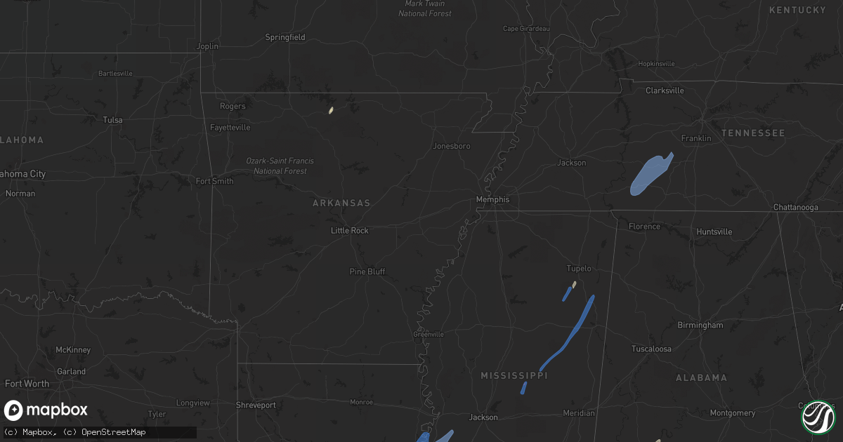
Hail Map in Ohio on May 25, 2022
Get this storm
May 25 map
$229
one time, instant access
Download today. No call, no setup
Keep the $229
Bought the map and want the full workflow? Apply the entire $229 to a subscription within 7 days. None of it is wasted.
Every map, not just this one
This buys you this map. Subscription and you get every map we run, in the markets you choose from a few cities to whole states to nationwide. Plus real-time alerts the moment a storm fires.
Contact data
Name, contact info, occupancy, even credit band for addresses in the footprint. You go from where it hit to who to call.
Become the source they trust
Unlimited branding weather history reports on demand. You already have the documented answer ready for the property owner, and you are the one who showed up with it.
Property data and RoofTrace estimates
Pull up any address you have got, its value and the exact code rules for that jurisdiction, straight from One Click Code. Then RoofTrace estimates the squares, pitch, and roof value, priced the way you price.
Storm reports in Ohio
Ohio
| Date | Description |
|---|---|
| 05/25/20224:57 AM CDT | At 957 PM EDT, a severe thunderstorm was located over Jamestown, moving north at 40 mph. HAZARD...60 mph wind gusts and penny size hail. SOURCE...Radar indicated. IMPACT...Expect damage to trees and power lines. Locations impacted include... Springfield, Urbana, London, Cedarville, Jamestown, South Charleston, Mechanicsburg, Choctaw Lake, Harmony, Lisbon, Brighton, Lafayette, South Vienna, Tremont City, South Solon, Bowersville, Catawba, Clifton, Mutual and Rosemoor.This includes the following Interstates... I-70 in Ohio between mile markers 53 and 78. I-71 in Ohio between mile markers 58 and 60. |
| 05/25/20224:27 AM CDT | At 927 PM EDT, a severe thunderstorm was located near Wilmington, moving north at 50 mph. HAZARD...60 mph wind gusts and penny size hail. SOURCE...Radar indicated. IMPACT...Expect damage to trees and power lines. Locations impacted include... Springfield, Xenia, Wilmington, Yellow Springs, Cedarville, Enon, Jamestown, South Charleston, Wilberforce, New Jasper, Bowersville, Port William, Clifton, Paintersville, Hustead, Lumberton, Oakland, Selma, Oldtown and Gladstone.This includes the following Interstates... I-70 in Ohio between mile markers 49 and 60. I-71 in Ohio between mile markers 46 and 56. |
| 05/25/20222:03 AM CDT | At 702 PM EDT, a severe thunderstorm was located over Decatur, moving north at 50 mph. HAZARD...60 mph wind gusts. SOURCE...Radar indicated. IMPACT...Expect damage to roofs, siding, and trees. Locations impacted include... Fort Wayne, New Haven, Decatur, Woodburn, Monroeville, Grabill, Monroe, Leo-cedarville, Middletown, Preble, Dixon, Edgerton In Allen County, Peterson, Zulu, Rivare, Townley, Magley, Harlan, Hessen Cassel and Monmouth.This includes the following highways... Interstate 469 between mile markers 12 and 30. Interstate 69 in Indiana near mile marker 320. |
| 05/24/20229:01 PM CDT | Report from mping: 1-inch tree limbs broken; shingles blown off. |
| 05/24/20228:37 PM CDT | 1 tree down near waynesville jamestown road and hoop road. |
| 05/24/20228:37 PM CDT | 1 tree down paintersville new jasper road |
| 05/24/20228:28 PM CDT | 2 trees down |
| 05/24/20228:26 PM CDT | 2 trees down. |
| 05/24/20227:54 PM CDT | Power pole down... Broken limbs... Pine trees uprooted... And roof damage to a post office. |
All States Impacted by Hail Map on May 25, 2022
Cities Impacted by Hail Map on May 25, 2022
- Burlington, KY
- Union, KY
- Dickinson, AL
- Alice, TX
- Flippin, AR
- Lower Peach Tree, AL
- Coy, AL
- Whatley, AL
- Pine Hill, AL
- Jackson, AL
- Grove Hill, AL
- Rushville, IN
- Concepcion, TX
- Milroy, IN
- Yellville, AR
- Okolona, MS
- Shannon, MS
- Mandeville, LA
- Lacombe, LA
- Elberta, AL
- Lillian, AL
- Madison, MO
- Michigantown, IN
- Walton, IN
- Twelve Mile, IN
- Thorntown, IN
- Kewanna, IN
- Bringhurst, IN
- Frankfort, IN
- Kokomo, IN
- Cutler, IN
- Young America, IN
- Burlington, IN
- Lucerne, IN
- Flora, IN
- Camden, IN
- Galveston, IN
- Russiaville, IN
- Kirklin, IN
- Lebanon, IN
- Logansport, IN
- Rochester, IN
- Donovan, IL
- Sheldon, IL
- Kentland, IN
- Thomasville, AL
- Vredenburgh, AL
- Beloit, WI
- Walterboro, SC
- Carthage, MS
- Baileyville, IL
- Waterproof, LA
- Saint Joseph, LA
- Woodville, MS
- Ferriday, LA
- Jonesville, LA
- Monterey, LA
- Port Gibson, MS
- Vidalia, LA
- Natchez, MS
- Newellton, LA
- Lorman, MS
- Fayette, MS
- Hermanville, MS
- Utica, MS
- Pattison, MS
- Roxie, MS
- Wesson, MS
- Crystal Springs, MS
- Hazlehurst, MS
- Lena, MS
- Philadelphia, MS
- West Point, MS
- Noxapater, MS
- Aberdeen, MS
- McCool, MS
- Amory, MS
- Starkville, MS
- Sturgis, MS
- Louisville, MS
- Houston, MS
- Hohenwald, TN
- Mount Pleasant, TN
- Williamsport, TN
- Collinwood, TN
- Waynesboro, TN
- Hampshire, TN
- Centerville, TN
- Duck River, TN
- Linden, TN
- Summertown, TN
- Lawrenceburg, TN
- Mount Auburn, IL
- Illiopolis, IL
- Mount Pulaski, IL
- Edinburg, IL
- Buffalo, IL
- Lincoln, IL
- Stonington, IL
- Blue Mound, IL
- Taylorville, IL
- Wilmington, OH
- Xenia, OH
- Jamestown, OH


