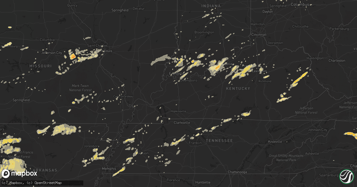
Hail Map in Missouri on May 23, 2011
Get this storm
May 23 map
$229
one time, instant access
Download today. No call, no setup
Keep the $229
Bought the map and want the full workflow? Apply the entire $229 to a subscription within 7 days. None of it is wasted.
Every map, not just this one
This buys you this map. Subscription and you get every map we run, in the markets you choose from a few cities to whole states to nationwide. Plus real-time alerts the moment a storm fires.
Contact data
Name, contact info, occupancy, even credit band for addresses in the footprint. You go from where it hit to who to call.
Become the source they trust
Unlimited branding weather history reports on demand. You already have the documented answer ready for the property owner, and you are the one who showed up with it.
Property data and RoofTrace estimates
Pull up any address you have got, its value and the exact code rules for that jurisdiction, straight from One Click Code. Then RoofTrace estimates the squares, pitch, and roof value, priced the way you price.
Storm reports in Missouri
Missouri
| Date | Description |
|---|---|
| 05/23/20114:25 PM CDT | Billboards and signs blown down between exits 61 and 67 on interstate 55 between sikeston and matthews. |
| 05/23/20114:00 PM CDT | From new wells to the perry county line...numerous trees down...3 to 4 barns with roofs blown off...shingles off a few houses |
| 05/23/20113:18 PM CDT | Large tree across highway m |
| 05/23/20112:12 PM CDT | Quarter-sized hail |
| 05/23/20111:45 PM CDT | An ef-0 tornado touched down 4 miles east norhteast of moody missouri. Damage in the area consisted of many large limbs broken out of trees...a home with minor roof dam |
| 05/23/20111:41 PM CDT | Metal carport blown onto road |
| 05/23/20111:12 PM CDT | Multiple large trees and power lines down with almost every road closed at st. Albans. Smaller trees down in gray summit. Estimated wind gust at 65 mph. |
| 05/23/201112:50 PM CDT | Shingles and debris blown about along with a pushed in garage door. |
| 05/23/201112:48 PM CDT | Several 4-6 inch branches down in the area of st. Louis university hospital. |
| 05/23/201112:45 PM CDT | Numerous trees... Branches... And power outages throughout the city from ksdk channel 5. |
| 05/23/201112:45 PM CDT | 3-inch diameter trees down at intersection of des peres road and wild deer road. 8-inch limb blocking warson woods drive near timberlake drive. |
| 05/23/201112:44 PM CDT | Three-inch tree down at 367 and parker intersection |
| 05/23/201112:40 PM CDT | Large tree uprooted onto home in tower grove. |
| 05/23/201112:35 PM CDT | 30 inch tree blocking road at hillsdale and normandy road. |
| 05/23/201112:35 PM CDT | 20 inch diameter tree down blocking traffic at arsenal and brannon. |
| 05/23/201112:32 PM CDT | 1 mile west of intersection of big bend and 141. |
| 05/23/201112:31 PM CDT | From the tower. |
| 05/23/201112:30 PM CDT | 12 inch branches down |
| 05/23/201112:29 PM CDT | Large limbs and trees down at 141 and big bend. One lane of southbound 141 blocked. |
| 05/23/201112:27 PM CDT | 3 9-18 inch trees down at meadowbrook country club near clayton and kerrs mill road. |
| 05/23/201112:23 PM CDT | Report is from the st. Albans area...trees up to 1 foot in diameter snapped |
| 05/23/201112:22 PM CDT | Numerous trees and at least one power line down in town. |
| 05/23/201112:16 PM CDT | Numerous finger to thumb size diameter branches down. |
| 05/23/201112:12 PM CDT | 50 to 60 mph gust at wentzville parkway at west meyer. |
| 05/23/201112:11 PM CDT | 55 to 60 mph winds estimated with 9-inch diameter trees bent over at a 90 degree angle. Winds lasted about 30 seconds. |
| 05/23/201112:06 PM CDT | Hall brothers lumber has roofing blown off. |
| 05/23/201112:05 PM CDT | A local report indicates 68 MPH wind near 2 N WASHINGTON |
| 05/23/201112:04 PM CDT | Small tree limbs down. Estimated winds of 40 to 50 mph. |
| 05/23/201112:02 PM CDT | Trees down along independence street in downtown union... Relayed by amateur radio. |
| 05/23/201112:00 PM CDT | Trees and power lines down throughout the county... Including along holt road in the south end... Hwy 100 in the north end... And live lines down in owensville. |
| 05/23/201112:00 PM CDT | Roof off a mobile home. Late report probably took place around noon. |
| 05/23/201111:59 AM CDT | 6 to 10 inch diameter limbs down...pea size hail |
| 05/23/201111:55 AM CDT | A few shingles blown off of some roofs. |
| 05/23/201111:50 AM CDT | Power out in the berger area along with pea size hail |
| 05/23/201111:42 AM CDT | Pea-size hail fell with this storm as well. No damage visible in the immediate area. |
| 05/23/201111:39 AM CDT | Tin sheets off of roofs and limbs down everywhere in town. |
| 05/23/201111:30 AM CDT | Three foot diameter tree uprooted near residence. Many other trees uprooted and limbs broken off near observer location. |
| 05/23/201111:30 AM CDT | Three foot diameter tree uprooted near residence. Many other trees uprooted and limbs broken off near observer location. |
| 05/23/201111:30 AM CDT | Several trees uprooted. One tree was 2 feet in diameter. |
| 05/23/201111:22 AM CDT | Dime to quarter sized hail reported near state route b/county road 1060 intersection. |
| 05/23/201110:55 AM CDT | Tree down across state route e just north of the route e/route a intersection. |
| 05/23/201110:43 AM CDT | Three foot diameter tree down in eldon. |
| 05/23/20119:35 AM CDT | A local report indicates 60 MPH wind near 5 S WHEATLAND |
| 05/23/20118:56 AM CDT | 60 to 70 mph wind gust and pea hail relayed by spotter |
| 05/23/20118:48 AM CDT | A local report indicates 1.00 inch wind near 1 W WEBB CITY |
| 05/23/20111:30 AM CDT | A national weather service storm survey team determined that an ef-1 tornado touched down one mile southwest of dogwood and tracked to the northeast for 9 miles lifing |
| 05/22/20118:01 PM CDT | A local report indicates 1.00 inch wind near NORBORNE |
All States Impacted by Hail Map on May 23, 2011
Cities Impacted by Hail Map on May 23, 2011
- Corydon, IN
- Independence, OH
- Cleveland, OH
- Bedford, OH
- Brecksville, OH
- Braggs, OK
- Muskogee, OK
- Chelsea, OK
- Claremore, OK
- Hagarville, AR
- Ozone, AR
- Deer, AR
- Oark, AR
- Jonesboro, IL
- Wolf Lake, IL
- Huntington, IN
- Stroud, OK
- Cushing, OK
- Merino, CO
- Booneville, AR
- Magazine, AR
- Akron, IN
- Rochester, IN
- Rudy, AR
- Harrodsburg, KY
- Okarche, OK
- Liberty, KS
- Wann, OK
- Altamont, KS
- Lenapah, OK
- Bartlett, KS
- Independence, KS
- Carl Junction, MO
- Webb City, MO
- Nowata, OK
- Mound Valley, KS
- Columbus, KS
- Tyro, KS
- Galena, KS
- Bartlesville, OK
- Baxter Springs, KS
- Niotaze, KS
- Coffeyville, KS
- Commerce, OK
- Miami, OK
- Havana, KS
- Cherryvale, KS
- Pittsburg, KS
- Vinita, OK
- Bluejacket, OK
- S Coffeyville, OK
- Welch, OK
- Quapaw, OK
- Joplin, MO
- Chetopa, KS
- North Miami, OK
- Delaware, OK
- Picher, OK
- Treece, KS
- Caney, KS
- Edna, KS
- Copan, OK
- Riverton, KS
- Oswego, KS
- Winona, KS
- Leoti, KS
- Taylorsville, KY
- Richfield, PA
- Cocolamus, PA
- McAlisterville, PA
- Millerstown, PA
- Mentor, OH
- Newkirk, OK
- Braman, OK
- Blackwell, OK
- Carnegie, OK
- Apache, OK
- Eminence, MO
- Birch Tree, MO
- Havana, AR
- Ballwin, MO
- Eureka, MO
- Pacific, MO
- Frankfort, KY
- Shelbyville, KY
- Dill City, OK
- Rocky, OK
- Hobart, OK
- Sentinel, OK
- Mountain View, OK
- Cordell, OK
- Gotebo, OK
- Dukedom, TN
- Martin, TN
- Dresden, TN
- Union Grove, NC
- North Wilkesboro, NC
- Branch, AR
- Charleston, AR
- Oneida, KY
- Booneville, KY
- Ricetown, KY
- Sextons Creek, KY
- Manchester, KY
- Wellington, KS
- Henryetta, OK
- Okmulgee, OK
- Okemah, OK
- Three Rivers, MI
- Constantine, MI
- Centreville, MI
- Mulberry, AR
- Bronson, MI
- Burr Oak, MI
- Atwood, KS
- Halifax, NC
- Jackson, NC
- Jackson, KY
- Bays, KY
- Flatgap, KY
- Campton, KY
- Sitka, KY
- Blaine, KY
- Louisa, KY
- Rousseau, KY
- Vancleve, KY
- Salyersville, KY
- Staffordsville, KY
- Stambaugh, KY
- Oil Springs, KY
- Ahoskie, NC
- Conway, NC
- Roanoke Rapids, NC
- Weldon, NC
- Margarettsville, NC
- Woodland, NC
- Seaboard, NC
- Garysburg, NC
- Shady Point, OK
- Wister, OK
- Hickory Ridge, AR
- Cherry Valley, AR
- North East, PA
- Findley Lake, NY
- Sherman, NY
- Clymer, NY
- Dobson, NC
- Elkin, NC
- State Road, NC
- Mount Airy, NC
- Markle, IN
- Hermitage, PA
- Lindon, CO
- Eddyville, IL
- Stonefort, IL
- Stockton, KS
- Glade, KS
- Phillipsburg, KS
- Logan, KS
- Logansport, IN
- Paoli, IN
- Hardinsburg, IN
- Utica, KS
- Ness City, KS
- Quinter, KS
- Dighton, KS
- Arnold, KS
- Beeler, KS
- Ransom, KS
- Bazine, KS
- McDonald, KS
- Twelve Mile, IN
- Milan, MI
- Britton, MI
- Huntsville, AR
- Wesley, AR
- Wagoner, OK
- Saint Elmo, IL
- Indiahoma, OK
- Frederick, OK
- Loveland, OK
- Hackett, AR
- Greenwood, AR
- Bon Aqua, TN
- Burns, TN
- Hurricane Mills, TN
- Nunnelly, TN
- Dickson, TN
- White Bluff, TN
- Lobelville, TN
- Only, TN
- McEwen, TN
- Tarboro, NC
- Whitakers, NC
- Bluffton, IN
- Colby, KS
- Edson, KS
- Princeton, IN
- Patoka, IN
- Fort Worth, TX
- Aledo, TX
- Mulhall, OK
- Coyle, OK
- Guthrie, OK
- Crescent, OK
- Memphis, TN
- Olive Branch, MS
- Marshall, OK
- Burghill, OH
- Masury, OH
- Brookfield, OH
- Fowler, OH
- Vienna, OH
- Chandler, IN
- Elberfeld, IN
- Bethlehem, PA
- Northampton, PA
- Schnecksville, PA
- Nazareth, PA
- Coplay, PA
- Bath, PA
- Slatington, PA
- Laurys Station, PA
- Whitehall, PA
- Rolla, MO
- Lawrenceburg, KY
- Hartsville, TN
- Castalian Springs, TN
- Lebanon, TN
- Puryear, TN
- Hazel, KY
- Spavinaw, OK
- Salina, OK
- Saint Louis, MO
- New Raymer, CO
- Padroni, CO
- Diamond, MO
- Granby, MO
- Neosho, MO
- Sarcoxie, MO
- Pierce City, MO
- Flat Rock, MI
- Carleton, MI
- Lamar, AR
- Scranton, AR
- New Blaine, AR
- Knoxville, AR
- Adrian, MI
- Tecumseh, MI
- Tipton, MI
- Onsted, MI
- Manitou Beach, MI
- Finchville, KY
- Simpsonville, KY
- Fisherville, KY
- Louisville, KY
- Salem, AR
- Viola, AR
- Madison, OH
- Perry, OH
- Harts, WV
- Dundee, MI
- Howe, OK
- Heavener, OK
- Hodgen, OK
- Depauw, IN
- Ramsey, IN
- New Salisbury, IN
- Vermilion, OH
- Stratton, CO
- Vona, CO
- Tahlequah, OK
- Millsap, TX
- Weatherford, TX
- New Haven, MO
- Washington, MO
- Roaring River, NC
- Wilkesboro, NC
- Hamilton, NC
- Waterford, PA
- Wattsburg, PA
- Union City, PA
- Erie, PA
- Imperial, NE
- Ponca City, OK
- Fairfax, OK
- Ralston, OK
- Marland, OK
- Gerald, MO
- Rosebud, MO
- Calumet, OK
- Saint James, MO
- South Haven, KS
- Willis, MI
- Belleville, MI
- Flora, IL
- Hominy, OK
- Skiatook, OK
- Pettigrew, AR
- Ozark, AR
- Hobgood, NC
- Covington, OK
- Fairmont, OK
- Wallace, KS
- Tribune, KS
- Sharon Springs, KS
- Enid, OK
- Nashville, TN
- Oakley, KS
- Monument, KS
- Huntingburg, IN
- Jasper, IN
- Laconia, IN
- Versailles, KY
- Bethune, CO
- Burlington, CO
- Scotland Neck, NC
- Oak City, NC
- Holliday, TX
- Seymour, TX
- Limon, CO
- Fayetteville, AR
- Argyle, TX
- Justin, TX
- Roanoke, TX
- Durant, OK
- Calera, OK
- Trenton, NE
- Culbertson, NE
- Plainville, KS
- Rock Creek, OH
- Painesville, OH
- Thompson, OH
- Geneva, OH
- Grand River, OH
- Sturgis, MI
- Pleasant Hill, NC
- North Manchester, IN
- Vienna, MO
- Vichy, MO
- Owensville, IN
- Garrettsville, OH
- Hiram, OH
- Mantua, OH
- Williston, TN
- Collierville, TN
- Rossville, TN
- Oakland, TN
- Denton, MD
- Ridgely, MD
- Greensboro, MD
- Hillsboro, MD
- McCook, NE
- Maywood, NE
- Santo, TX
- Lipan, TX
- Mocksville, NC
- Perry, OK
- Noble, IL
- Somerville, TN
- Bagdad, KY
- Flagler, CO
- Seibert, CO
- Quinton, OK
- Healy, KS
- Murphysboro, IL
- Imboden, AR
- Suffolk, VA
- Carrollton, VA
- Crowell, TX
- Idalia, CO
- Winona, MO
- Ellington, MO
- Washington, NC
- Ossian, IN
- Uniondale, IN
- Andrews, IN
- Lagro, IN
- Keenes, IL
- Fort Branch, IN
- Haubstadt, IN
- Hermann, MO
- Eucha, OK
- Eufaula, OK
- Kingfisher, OK
- Carterville, IL
- Carbondale, IL
- De Soto, IL
- Perkins, OK
- Savannah, TN
- Sandoval, IL
- Odin, IL
- Salem, IL
- Marked Tree, AR
- Trumann, AR
- Mount Vernon, IN
- Villa Ridge, MO
- Gray Summit, MO
- Labadie, MO
- Corinth, KY
- Berry, KY
- Boynton, OK
- Barlow, KY
- Wickliffe, KY
- Sizerock, KY
- Hyden, KY
- Bear Branch, KY
- Buckhorn, KY
- Dallas, TX
- Irving, TX
- Colleyville, TX
- Bedford, TX
- Euless, TX
- Herndon, PA
- Port Trevorton, PA
- Bradford, PA
- Stillwater, OK
- Amherst, VA
- Harmony, NC
- Hamptonville, NC
- Olin, NC
- Weskan, KS
- Georgetown, KY
- Owensville, MO
- Rushsylvania, OH
- Woodrow, CO
- Genoa, CO
- Fremont, OH
- Vickery, OH
- Lewisville, TX
- Lake Dallas, TX
- Flower Mound, TX
- Denton, TX
- Ponder, TX
- Pottsville, AR
- Russellville, AR
- Mounds, OK
- Sapulpa, OK
- Saint Marys, OH
- Scotts Hill, TN
- Reagan, TN
- Newburgh, IN
- Wyandotte, OK
- Moss, TN
- Red Boiling Springs, TN
- Hoxie, KS
- Mount Pleasant Mills, PA
- McClure, PA
- Beaver Springs, PA
- Mifflintown, PA
- Pocahontas, AR
- Carrier Mills, IL
- Harrisburg, IL
- Ripley, NY
- Ashville, NY
- Fairview, PA
- Corry, PA
- Girard, PA
- Lake City, PA
- McKean, PA
- Jamestown, NY
- Panama, NY
- Harborcreek, PA
- Pinetops, NC
- Rocky Mount, NC
- Elm City, NC
- Elyria, OH
- Grafton, OH
- Columbia Station, OH
- Avon, OH
- Strongsville, OH
- North Royalton, OH
- North Olmsted, OH
- Berea, OH
- Olmsted Falls, OH
- North Ridgeville, OH
- Brookpark, OH
- High Ridge, MO
- Windham, OH
- New Haven, KY
- Birdseye, IN
- Holland, IN
- Schnellville, IN
- Saint Anthony, IN
- Dale, IN
- Ferdinand, IN
- Clayton, IN
- De Graff, OH
- Quincy, OH
- Longdale, OK
- Ringwood, OK
- Meno, OK
- Helena, OK
- Buncombe, IL
- Anna, IL
- Foreman, AR
- Haworth, OK
- Carlisle, KY
- Sharpsburg, KY
- Noel, MO
- Purlear, NC
- Stanton, TN
- Douglas, OK
- Orlando, OK
- Bison, OK
- Hennessey, OK
- Waldron, AR
- Lexington, KY
- Wakeeney, KS
- Loyal, OK
- Canton, OK
- Belleville, AR
- Danville, AR
- Ola, AR
- Addison, TX
- Grapevine, TX
- Carrollton, TX
- Coppell, TX
- Centralia, IL
- Kell, IL
- Williamston, NC
- Robersonville, NC
- Kirk, CO
- Oakwood, OK
- Vevay, IN
- Bennington, IN
- Zeigler, IL
- Millers Creek, NC
- Elizabeth, IN
- New Middletown, IN
- Manchester, MI
- Maybee, MI
- Monroe, MI
- Brooklyn, MI
- Napoleon, MI
- Grass Lake, MI
- Norvell, MI
- Jackson, MI
- Elkins, AR
- Canal Winchester, OH
- Mason, IL
- Altamont, IL
- Electra, TX
- Julian, WV
- Spurlockville, WV
- Alkol, WV
- Danville, WV
- Tryon, OK
- Scott City, KS
- Watonga, OK
- Grand Prairie, TX
- Dalmatia, PA
- Lykens, PA
- Elizabethville, PA
- Pillow, PA
- Bells, TN
- Brownsville, TN
- Jackson, TN
- Denmark, TN
- Gadsden, TN
- Decaturville, TN
- Webbers Falls, OK
- Lahoma, OK
- Prue, OK
- Tipton, OK
- Snyder, CO
- Wapakoneta, OH
- Puxico, MO
- Wappapello, MO
- Kelford, NC
- Equality, IL
- Halls, TN
- Trenton, TN
- Newbern, TN
- Dyersburg, TN
- Stilwell, OK
- Welling, OK
- Oblong, IL
- Annapolis, IL
- Milan, TN
- Olney, IL
- Sullivan, MO
- Leslie, MO
- Harrisburg, AR
- Edmond, OK
- Ohio City, OH
- Willshire, OH
- Decatur, IN
- Warner, OK
- Porum, OK
- Tyronza, AR
- Gilmore, AR
- Bay, AR
- Turrell, AR
- Lake City, AR
- Earle, AR
- Joiner, AR
- Roanoke, IN
- Airville, PA
- Bristow, IN
- Chesterfield, MO
- Winslow, AR
- West Fork, AR
- Prairie Grove, AR
- Farmington, AR
- Lincoln, AR
- Bogue, KS
- Clay City, IL
- Mount Washington, KY
- Coxs Creek, KY
- Lebanon Junction, KY
- Clermont, KY
- Shepherdsville, KY
- Whiteville, TN
- Combs, AR
- Brandenburg, KY
- Beaufort, MO
- Union, MO
- Lewiston Woodville, NC
- Windsor, NC
- Mammoth Spring, AR
- Ash Flat, AR
- Hardy, AR
- Cherokee Village, AR
- Chrisney, IN
- Rockport, IN
- Witter, AR
- Saint Paul, AR
- Vernon, IL
- Saint Peter, IL
- Shobonier, IL
- Alma, IL
- Patoka, IL
- Kinmundy, IL
- Vandalia, IL
- Springdale, AR
- Paris, AR
- Battletown, KY
- Mauckport, IN
- Central, IN
- Mountainburg, AR
- Shoshoni, WY
- Marion, IL
- Meeker, CO
- Forest, OH
- Inola, OK
- Coweta, OK
- Porter, OK
- Drumright, OK
- Bristow, OK
- Depew, OK
- Winchester, KY
- Richmond, KY
- Solon, OH
- Twinsburg, OH
- Valliant, OK
- Azle, TX
- Saint Jacob, IL
- Yadkinville, NC
- Klingerstown, PA
- Valley View, PA
- Hegins, PA
- Sacramento, PA
- Pitman, PA
- Traphill, NC
- Locust Grove, OK
- Saint Clair, MO
- Stockton, MO
- Indianapolis, IN
- Dundas, IL
- Ovid, CO
- Sedgwick, CO
- Macedonia, OH
- Van Alstyne, TX
- Converse, IN
- Peru, IN
- La Fontaine, IN
- Warren, IN
- Van Buren, IN
- Amboy, IN
- Marion, IN
- Greenville, MO
- Silva, MO
- Arapahoe, CO
- Waddy, KY
- Macedonia, IL
- Thompsonville, IL
- Piedmont, OK
- Yukon, OK
- Marthasville, MO
- Warrenton, MO
- Champion, NE
- Morris, OK
- Vian, OK
- Oktaha, OK
- Council Hill, OK
- Checotah, OK
- Gore, OK
- Stigler, OK
- Mountain Home, AR
- Mount Carmel, IL
- Aviston, IL
- Pocahontas, IL
- Carlyle, IL
- Highland, IL
- Breese, IL
- Colcord, OK
- Watts, OK
- Siloam Springs, AR
- Piedmont, MO
- Terrell, TX
- Mena, AR
- Mount Sterling, KY
- Piqua, OH
- Sidney, OH
- Fort Monroe, VA
- Newport News, VA
- Hampton, VA
- Norfolk, VA
- Farmdale, OH
- Cortland, OH
- Humboldt, TN
- Omega, OK
- Ames, OK
- Cashion, OK
- Jones, OK
- Cleo Springs, OK
- Dover, OK
- Southard, OK
- Goltry, OK
- Seiling, OK
- Hitchcock, OK
- Oklahoma City, OK
- El Reno, OK
- Isabella, OK
- Okeene, OK
- Luther, OK
- Fairview, OK
- Fenton, MO
- Willow Hill, IL
- Yale, IL
- French Lick, IN
- Milltown, IN
- Crandall, IN
- Arlington, TX
- Haltom City, TX
- Foster, WV
- Agate, CO
- New Washington, IN
- Canehill, AR
- Caulfield, MO
- Bakersfield, MO
- Medford, OK
- Warren, OH
- Caldwell, KS
- Robertsville, MO
- Catawissa, MO
- Sharpsville, PA
- Mercer, PA
- Warrensburg, MO
- Wynne, AR
- Denver, IN
- Roann, IN
- Newton Falls, OH
- Southington, OH
- Leavittsburg, OH
- Skippers, VA
- Emporia, VA
- Garrett, IN
- Auburn, IN
- Roland, OK
- Muldrow, OK
- Van Buren, AR
- Spiro, OK
- Arkoma, OK
- Fort Smith, AR
- Noblesville, IN
- Winfield, KS
- Richland, IN
- Dunnellon, FL
- Ocala, FL
- Cadiz, KY
- Bumpus Mills, TN
- Big Rock, TN
- Pleasant Shade, TN
- Lafayette, TN
- Hoyleton, IL
- Okawville, IL
- Annapolis, MO
- Bradner, OH
- Risingsun, OH
- Boulder, CO
- Salamanca, NY
- Limestone, NY
- Haslet, TX
- Flippin, AR
- Gassville, AR
- Yellville, AR
- Cotter, AR
- Gamaliel, AR
- Saint Francis, KS
- Kanorado, KS
- Bloomfield, KY
- Bardstown, KY
- Mooresville, IN
- Plainfield, IN
- Chagrin Falls, OH
- Aurora, OH
- Chaffee, MO
- Whitewater, MO
- Cape Girardeau, MO
- Advance, MO
- Smithton, MO
- Sedalia, MO
- Otterville, MO
- Collyer, KS
- Jonesville, NC
- Ronda, NC
- Geuda Springs, KS
- Lanesville, IN
- McLeansboro, IL
- New Albany, IN
- Georgetown, IN
- Floyds Knobs, IN
- Clarksville, IN
- Celestine, IN
- Dubois, IN
- Hays, KS
- Bristolville, OH
- Dongola, IL
- Shoals, IN
- Bokchito, OK
- North Vernon, IN
- Bellefontaine, OH
- Monticello, KY
- Rising Sun, IN
- Vincennes, IN
- Felton, DE
- Harrington, DE
- Pryor, OK
- Henderson, TN
- Finger, TN
- Elk City, KS
- Sedan, KS
- Celina, TN
- Brownell, KS
- Kingston, AR
- Ponca, AR
- Waukomis, OK
- Burton, OH
- Liberty Center, IN
- Kaw City, OK
- Falmouth, KY
- Sunman, IN
- Branchville, VA
- Boykins, VA
- Belle Plaine, KS
- Fairfield, KY
- Claremont, IL
- Celeste, TX
- Cope, CO
- Flat Rock, IN
- Edinburgh, IN
- Anton, CO
- Henderson, KY
- Houston, OH
- Russia, OH
- Kansas, OK
- Hartsburg, MO
- Centertown, MO
- Jefferson City, MO
- Ewing, IL
- Dahlgren, IL
- Belle Rive, IL
- Fort Gibson, OK
- Rexford, KS
- Alpha, KY
- Albany, KY
- House Springs, MO
- Rattan, OK
- Fort Towson, OK
- Osage, OK
- Pleasant Hill, OH
- Ludlow Falls, OH
- Laura, OH
- Francisco, IN
- Winslow, IN
- Lynnville, IN
- Petersburg, IN
- Evansville, IN
- Oakland City, IN
- Hestand, KY
- O'Fallon, IL
- Dyer, TN
- Garber, OK
- Dunnegan, MO
- Bolivar, MO
- Raymondville, MO
- Houston, MO
- Jetson, KY
- Roundhill, KY
- Blytheville, AR
- Northfield, OH
- Maple Heights, OH
- Columbia, MO
- Ashland, MO
- Summers, AR
- Craigville, IN
- Luxora, AR
- Bellevue, OH
- Julesburg, CO
- Pawhuska, OK
- Selinsgrove, PA
- Spring Glen, PA
- Morrilton, AR
- Opdyke, IL
- Mount Vernon, IL
- Ina, IL
- Paris, KY
- West Liberty, IL
- Augusta, MO
- Sevierville, TN
- Beggs, OK
- Cambridge, KS
- Subiaco, AR
- Queen Anne, MD
- Cordova, MD
- Amherst, OH
- Lorain, OH
- Ellis, KS
- Plano, TX
- Allen, TX
- Boston, KY
- Ellenboro, NC
- Murfreesboro, NC
- Aulander, NC
- Pendleton, NC
- Brownsville, KY
- Sweeden, KY
- Keller, TX
- Lavaca, AR
- Newburg, MO
- Kingston Springs, TN
- Norborne, MO
- Defiance, MO
- Fairfield, IL
- Barnhill, IL
- Grove City, OH
- Knobel, AR
- Pineville, AR
- Wideman, AR
- Dolph, AR
- Boonville, IN
- Hermitage, MO
- Clarksville, AR
- Stamping Ground, KY
- Urbana, IN
- Lepanto, AR
- Holden, MO
- Alma, AR
- Seneca, MO
- Little Elm, TX
- Nesbit, MS
- Southaven, MS
- Poseyville, IN
- Bexar, AR
- Jay, OK
- Ratcliff, AR
- Arcadia, OK
- Drummond, OK
- Spencer, OK
- Carrier, OK
- West Liberty, KY
- Des Arc, MO
- Pinckneyville, IL
- Darden, TN
- Mechanicsburg, OH
- Woodstock, OH
- Cable, OH
- Fort Cobb, OK
- Fort Morgan, CO
- Williston, FL
- Morriston, FL
- Browns, IL
- Ellery, IL
- Albion, IL
- Blue Mountain, AR
- Dardanelle, AR
- London, AR
- Coal Hill, AR
- Mansfield, AR
- Rover, AR
- Hartman, AR
- Altus, AR
- Delaware, AR
- Ravenden, AR
- Franklin, AR
- Camp, AR
- Calico Rock, AR
- Oxford, AR
- Glencoe, AR
- Brockwell, AR
- Elizabeth, AR
- Horseshoe Bend, AR
- Wiseman, AR
- Sturkie, AR
- Williford, AR
- Lawton, OK
- Cache, OK
- Hindsville, AR
- Paris, IL
- Advance, NC
- Arthur, NE
- Murray, KY
- West Farmington, OH
- Bargersville, IN
- Franklin, IN
- Urbana, OH
- Friendship, TN
- Wildwood, MO
- Valley Park, MO
- Martinsville, IN
- Greenwood, IN
- West Mansfield, OH
- Ridgeway, OH
- East Saint Louis, IL
- Salvisa, KY
- Bloomington, IN
- Sikeston, MO
- Nash, OK
- Fort Wayne, IN
- La Grange, KY
- Goshen, KY
- Crestwood, KY
- Goodland, KS
- Crofton, KY
- Cambria, IL
- Mccurtain, OK
- Cameron, OK
- Poteau, OK
- Red Oak, OK
- Cecil, AR
- Bokoshe, OK
- Pocola, OK
- Barling, AR
- Dover, AR
- Boles, AR
- Huntington, AR
- Plainview, AR
- Du Quoin, IL
- Rich Square, NC
- Roxobel, NC
- Colerain, NC
- Levant, KS
- Owenton, KY
- South Whitley, IN
- Kaufman, TX
- Chocowinity, NC
- Wellington, CO
- Fort Collins, CO
- Berryville, AR
- Sharon, PA
- Hulbert, OK
- Goodlettsville, TN
- Deer Trail, CO
- Wills Point, TX
- Marble Hill, MO
- Benton, IL
- Mulkeytown, IL
- West Frankfort, IL
- Royalton, IL
- Centerville, TN
- Hohenwald, TN
- Duck River, TN
- Westville, OK
- Tamaroa, IL
- Galveston, IN
- Kokomo, IN
- Aubrey, TX
- Prosper, TX
- Frisco, TX
- Rosedale, IN
- Centerview, MO
- Gates, TN
- Midway, KY
- Willisburg, KY
- Chaplin, KY
- Mount Eden, KY
- Grinnell, KS
- Fort Loramie, OH
- Minster, OH
- Columbus, OH
- Broadview Heights, OH
- Westlake, OH
- Deckerville, MI
- New Boston, MI
- Arnold, MO
- Smithfield, VA
- Seymour, IN
- Brownstown, IN
- Holladay, TN
- Wildersville, TN
- Gleason, TN
- Bunker Hill, IN
- Vernon, TX
- Morral, OH
- New Bloomington, OH
- Spencerville, OH
- Atlanta, IN
- Anderson, IN
- Arcadia, IN
- Cicero, IN
- Frewsburg, NY
- Sellersburg, IN
- Berger, MO
- Chandler, OK
- Talala, OK
- Oklaunion, TX
- Palestine, IL
- Robinson, IL
- Flat Rock, IL
- Fairland, OK
- Peru, KS
- Afton, OK
- Carterville, MO
- Dewey, OK
- Dearing, KS
- Aurora, CO
- Arriba, CO
- Carthage, MO
- Velpen, IN
- Windsor, VA
- Portsmouth, VA
- Saline, MI
- Ann Arbor, MI
- Enfield, NC
- Sesser, IL
- Columbia City, IN
- Churubusco, IN
- Creal Springs, IL
- Stoneham, CO
- Broken Bow, OK
- Hughesville, MO
- Liverpool, PA
- Brazil, IN
- Wabash, IN
- Macy, IN
- Upper Sandusky, OH
- Glenallen, MO
- Lowndes, MO
- Gipsy, MO
- Laotto, IN
- Yale, OK
- Pond Creek, OK
- Lamont, OK
- Macclesfield, NC
- Brush, CO
- Proctor, OK
- Franklin, VA
- Gove, KS
- Thomas, OK
- Taloga, OK
- Akron, CO
- Holyoke, CO
- Warsaw, IN
- Claypool, IN
- Pierceton, IN
- The Colony, TX
- Burkesville, KY
- Oak Ridge, MO
- Jackson, MO
- Union, KY
- Weir, KS
- Scammon, KS
- Dennis, KS
- Oronogo, MO
- McCune, KS
- Parsons, KS
- Chautauqua, KS
- Asbury, MO
- Oxford, KS
- Conway, MO
- Phillipsburg, MO
- Parks, AR
- New Albany, OH
- Johnstown, OH
- Sidell, IL
- Natoma, KS
- Troy, MO
- Golden Gate, IL
- Palmersville, TN
- Greenville, PA
- Kinsman, OH
- Wadesville, IN
- Sullivan, IN
- Merom, IN
- Avilla, IN
- Kendallville, IN
- Broadlands, IL
- Allerton, IL
- Hendersonville, TN
- Danville, IN
- Jerico Springs, MO
- El Dorado Springs, MO
- Steele, MO
- Hornersville, MO
- Delphos, OH
- Fort Jennings, OH
- Royal Center, IN
- Laketon, IN
- Lucerne, IN
- Redford, MO
- Lawrenceville, VA
- Valentines, VA
- Vulcan, MO
- Saint Joe, AR
- Dexter, KY
- Almo, KY
- Monroe, IN
- Rockford, OH
- Wren, OH
- Poneto, IN
- Van Wert, OH
- Servia, IN
- Burnettsville, IN
- Hoagland, IN
- Berne, IN
- Mexico, IN
- Liberty Mills, IN
- Yoder, IN
- Convoy, OH
- Pickerington, OH
- Irvington, KY
- Henderson, AR
- Summit, AR
- Canton, MI
- Wayne, MI
- Romulus, MI
- Patterson, MO
- Parthenon, AR
- Compton, AR
- Jasper, AR
- Chouteau, OK
- Wayne City, IL
- Bone Gap, IL
- West Salem, IL
- Harned, KY
- Garfield, KY
- Greenville, NC
- Enders, NE
- Owensboro, KY
- Hermitage, TN
- Herod, IL
- Golconda, IL
- North Bloomfield, OH
- Lohman, MO
- Monroeville, IN
- Cuba, MO
- Elkland, MO
- Marion, OH
- Prospect, OH
- La Rue, OH
- Richwood, OH
- Dora, MO
- Columbia, IL
- Millstadt, IL
- Burbank, OK
- Moscow Mills, MO
- Old Monroe, MO
- Winfield, MO
- Ferguson, NC
- Kennedale, TX
- Hurst, TX
- Naval Air Station Jrb, TX
- Cresson, TX
- Crowley, TX
- North Richland Hills, TX
- Bennington, OK
- Lamar, MO
- Jasper, MO
- Evansville, AR
- Morrow, AR
- Bunch, OK
- Chester, AR
- Red Bud, IL
- New Athens, IL
- Covington, OH
- Neodesha, KS
- Columbus Grove, OH
- Ottawa, OH
- West Plains, MO
- Raleigh, IL
- Galatia, IL
- Eldorado, IL
- Jet, OK
- Jefferson, OH
- Austinburg, OH
- Corydon, KY
- Robards, KY
- Sedgewickville, MO
- California, MO
- Chamois, MO
- Linn, MO
- Bland, MO
- Mount Sterling, MO
- Hazel Green, KY
- Belle Center, OH
- Huntsville, OH
- Brownstown, IL
- Byrdstown, TN
- Sandy Hook, KY
- Verona, KY
- Anderson, MO
- Dixon, MO
- Benedict, KS
- Latham, MO
- Clarksburg, MO
- Fairland, IN
- Peetz, CO
- Casper, WY
- English, IN
- Eckerty, IN
- Tennyson, IN
- Saint Croix, IN
- Saint Meinrad, IN
- Lincoln City, IN
- Gentryville, IN
- Fairdale, KY
- Ypsilanti, MI
- Zalma, MO
- Harrisonville, MO
- Garden City, MO
- Leavenworth, IN
- Charlestown, IN
- Belle, MO
- Sheldon, MO
- Waverly, TN
- Reed, KY
- Sterling, CO
- Stendal, IN
- Owasso, OK
- Sperry, OK
- Collinsville, OK
- Louisville, IL
- Logan, IL
- Bloomfield, IN
- Wynona, OK
- Bluford, IL
- Buffalo, MO
- Louisburg, MO
- Dayton, OH
- Sharon, TN
- Rives, TN
- Ringold, OK
- Capron, VA
- Drewryville, VA
- Preston, MO
- Harrod, OH
- Bluffton, OH
- Ada, OH
- Morgantown, IN
- Litchfield, MI
- Jonesville, MI
- Barnsdall, OK
- Cannel City, KY
- Fremont, IN
- Omaha, IL
- Norris City, IL
- Holton, IN
- Butlerville, IN
- Salem, IN
- Campbellsburg, IN
- Xenia, IL
- Lonsdale, AR
- Glenpool, OK
- Jenks, OK
- Marissa, IL
- Hardinsburg, KY
- Fulton, MO
- Clarklake, MI
- Dunkirk, OH
- Carlisle, IN
- Gravois Mills, MO
- Barnett, MO
- Rocky Mount, MO
- Niangua, MO
- Watson, IL
- Effingham, IL
- Yorktown, VA
- Lima, OH
- Jamesville, NC
- Maple City, KS
- Harrah, OK
- Meridian, OK
- Marquand, MO
- Strang, OK
- Adair, OK
- Alamo, TN
- Memphis, IN
- West Point, KY
- Jeffersonville, IN
- Guston, KY
- Ekron, KY
- Payneville, KY
- Borden, IN
- Hudson, MI
- Clayton, MI
- Humansville, MO
- Palco, KS
- Wilburton, OK
- Waynesboro, TN
- Mendon, OH
- Bartelso, IL
- New Baden, IL
- Albers, IL
- Germantown, IL
- Detroit, MI
- Lucien, OK
- Port Jefferson, OH
- Oden, AR
- Sims, AR
- Mount Ida, AR
- Pencil Bluff, AR
- Pleasureville, KY
- Eminence, KY
- Greenfield, TN
- Allons, TN
- Ripley, OK
- Park Hill, OK
- Ulysses, KY
- Paintsville, KY
- River, KY
- Linn Creek, MO
- Gentry, AR
- Fairview Heights, IL
- Perryville, AR
- New Concord, KY
- Long Lane, MO
- Grovespring, MO
- Spottsville, KY
- Falcon, MO
- Hazleton, IN
- Roach, MO
- Monrovia, IN
- Stilesville, IN
- Patton, MO
- Thousandsticks, KY
- Busy, KY
- Krypton, KY
- Dyess, AR
- Etowah, AR
- Osceola, AR
- Florissant, MO
- Joes, CO
- Franklin, TN
- Saint Francisville, IL
- Allendale, IL
- McCrory, AR
- Collinwood, TN
- Olivehill, TN
- Oran, MO
- Kellyville, OK
- Mount Juliet, TN
- Gallatin, TN
- Old Hickory, TN
- Cape Charles, VA
- Gepp, AR
- Moody, MO
- Clark, PA
- Sheffield Lake, OH
- Streetsboro, OH
- Ravenna, OH
- Newbury, OH
- Farrell, PA
- Pine Bluffs, WY
- Williamsville, MO
- Hill City, KS
- Ogallah, KS
- Versailles, MO
- Ezel, KY
- Orleans, IN
- Morrison, MO
- Kiefer, OK
- Bella Vista, CA
- Branchville, IN
- Leopold, IN
- Scott City, MO
- Brookston, IN
- Delphi, IN
- Mansfield, TX
- Marmaduke, AR
- Broseley, MO
- Radnor, OH
- Antlers, OK
- Telephone, TX
- Ivanhoe, TX
- Lyons, IN
- Hoffman, IL
- Walnut Hill, IL
- Iuka, IL
- Qulin, MO
- Dornsife, PA
- Rebuck, PA
- Flemington, MO
- Chesapeake, VA
- Pittsburg, IL
- Silver Lake, IN
- McCracken, KS
- Morland, KS
- Sallisaw, OK
- Harpster, OH
- Lenzburg, IL
- Mascoutah, IL
- Kenton, TN
- Trimble, TN
- Hugo, OK
- Bradford, OH
- Westland, MI
- Inkster, MI
- Horatio, AR
- Kuttawa, KY
- Gandeeville, WV
- Sardis, TN
- Bath Springs, TN
- Bee Spring, KY
- Mammoth Cave, KY
- Bethel, NC
- Delaplaine, AR
- Nashville, IL
- Conifer, CO
- Gravette, AR
- Catharine, KS
- Sulphur Springs, AR
- Altoona, KS
- Fredonia, KS
- Altenburg, MO
- Grand Tower, IL
- Plymouth, NC
- Lexington, TN
- Peach Orchard, AR
- Newsoms, VA
- Gates, NC
- Como, NC
- Enville, TN
- Hanover, IN
- Milton, KY
- Lexington, IN
- Buckner, IL
- Orient, IL
- Hurst, IL
- Mistletoe, KY
- Big Cabin, OK
- Ripley, TN
- Oakdale, IL
- Mannford, OK
- Cardwell, MO
- Clinton, MO
- Whites Creek, TN
- McClure, IL
- Grove, OK
- Addieville, IL
- Rose, OK
- Alton, IL
- Cottage Hills, IL
- Bethalto, IL
- Saint Paris, OH
- Baltimore, OH
- Hebron, OH
- Pataskala, OH
- Millersport, OH
- Walnutport, PA
- Allentown, PA
- Wakita, OK
- Poolesville, MD
- Dickerson, MD
- Clifton, TN
- Shelburn, IN
- Allegany, NY
- Polk, MO
- Seagoville, TX
- New Palestine, IN
- Macks Creek, MO
- Gratz, PA
- Tower City, PA
- Ashland, PA
- Isonville, KY
- Elkville, IL
- Vergennes, IL
- Celina, OH
- Wheatland, MO
- Whitleyville, TN
- Tompkinsville, KY
- Dixon Springs, TN
- Oakland Mills, PA
- Lone Wolf, OK
- Larwill, IN
- Stokes, NC
- Germantown, MD
- Goldsboro, MD
- Saratoga Springs, UT
- Eagle Mountain, UT
- Cedar Valley, UT


