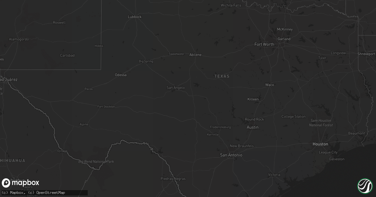
Hail Map in Texas on May 22, 2022
Get this storm
May 22 map
$229
one time, instant access
Download today. No call, no setup
Keep the $229
Bought the map and want the full workflow? Apply the entire $229 to a subscription within 7 days. None of it is wasted.
Every map, not just this one
This buys you this map. Subscription and you get every map we run, in the markets you choose from a few cities to whole states to nationwide. Plus real-time alerts the moment a storm fires.
Contact data
Name, contact info, occupancy, even credit band for addresses in the footprint. You go from where it hit to who to call.
Become the source they trust
Unlimited branding weather history reports on demand. You already have the documented answer ready for the property owner, and you are the one who showed up with it.
Property data and RoofTrace estimates
Pull up any address you have got, its value and the exact code rules for that jurisdiction, straight from One Click Code. Then RoofTrace estimates the squares, pitch, and roof value, priced the way you price.
Storm reports in Texas
Texas
| Date | Description |
|---|---|
| 05/22/20228:05 AM CDT | Shed blown over. |
| 05/22/20227:55 AM CDT | At 1255 AM CDT, a severe thunderstorm was located near Normandy, or near Quemado, moving northeast at 35 mph. HAZARD...70 mph wind gusts and quarter size hail. SOURCE...Radar indicated. IMPACT...Hail damage to vehicles is expected. Expect considerable tree damage. Wind damage is also likely to mobile homes, roofs, and outbuildings. Locations impacted include... Spofford, Quemado, Paloma, Radar Base, Normandy, Darling and Laughlin AFB Aux Field. |
| 05/22/20227:10 AM CDT | At 1207 PM CDT, a severe thunderstorm was located over Lopeno, moving south at 20 to 25 mph. HAZARD...Ping pong ball size hail and 60 mph wind gusts. SOURCE...Radar indicated. IMPACT...People and animals outdoors will be injured. Expect hail damage to roofs, siding, windows, and vehicles. Expect wind damage to roofs, siding, and trees. Locations impacted include... Lopeno, New Falcon, Falcon Dam, Morales-Sanchez, Salineno, Falcon Heights and Falcon State Park.This includes US Highway 83 between mile markers 774 and 800. |
| 05/22/20226:26 AM CDT | At 1123 AM CDT, a severe thunderstorm was located over Zapata County Airport, or near Zapata, moving southeast at 15 to 20 mph. HAZARD...60 mph wind gusts and quarter size hail. SOURCE...Radar indicated. IMPACT...Hail damage to vehicles is expected. Expect wind damage to roofs, siding, and trees. Locations impacted include... Zapata, Bustamante, Medina, Zapata High School, Zapata County Fire Department, Zapata Middle School, Siesta Shores, Zapata County Public Library, Las Palmas and Falcon Mesa.This includes US Highway 83 between mile markers 756 and 780. |
| 05/22/20225:57 AM CDT | At 1056 AM CDT, a severe thunderstorm was located 10 miles north of Zapata County Airport, or 11 miles northwest of Bustamante, moving southeast at 20 mph. HAZARD...60 mph wind gusts and quarter size hail. SOURCE...Radar indicated. IMPACT...Hail damage to vehicles is expected. Expect wind damage to roofs, siding, and trees. Locations impacted include... Zapata, Bustamante, Medina, Zapata High School, Zapata County Fire Department, Escobas, Zapata Middle School, Zapata County Public Library, Las Palmas and Zapata County Airport.This includes US Highway 83 between mile markers 748 and 750, betweenmile markers 754 and 758, and between mile markers 762 and 768. |
| 05/22/20225:32 AM CDT | At 1032 AM CDT, a severe thunderstorm was located 13 miles northwest of Bustamante, moving southeast at 30 mph. HAZARD...60 mph wind gusts and quarter size hail. SOURCE...Radar indicated. IMPACT...Hail damage to vehicles is expected. Expect wind damage to roofs, siding, and trees. Locations impacted include... Bustamante and Escobas. |
| 05/22/20222:40 AM CDT | At 740 AM CDT, severe thunderstorms were located along a line extending from 6 miles west of Driscoll to Premont, moving southeast at 15 mph. HAZARD...60 mph wind gusts and quarter size hail. SOURCE...Radar indicated. IMPACT...Hail damage to vehicles is expected. Expect wind damage to roofs, siding, and trees. Locations impacted include... Kingsville, Premont, Bishop, Ben Bolt, Riviera, Palito Blanco, La Gloria, Ricardo, Kingsville Naval Air Station and Loyola Beach.This includes the following highways... US Highway 281 between mile markers 682 and 708. US Highway 77 between mile markers 682 and 708. |
| 05/21/202210:53 PM CDT | At 352 AM CDT, a severe thunderstorm was located near Columbia Bridge, or 23 miles northwest of Laredo, moving east at 30 mph. HAZARD...60 mph wind gusts and quarter size hail. SOURCE...Radar indicated. IMPACT...Hail damage to vehicles is expected. Expect wind damage to roofs, siding, and trees. Locations impacted include... Laredo, Ranchos Penitas West, Columbia Bridge, Botines and Unitec Industrial Park.This includes the following highways... Interstate 35 between mile markers 10 and 23. US Highway 83 between mile markers 690 and 698. |
| 05/21/20229:48 PM CDT | At 245 AM CDT, a severe thunderstorm was located over Victoria Mall, or near Victoria, moving east at 30 mph. HAZARD...60 mph wind gusts. SOURCE...Radar indicated. IMPACT...Expect damage to roofs, siding, and trees. Locations impacted include... Victoria, Guadalupe, Victoria Colony Creek Country Club, Wood Hi, Mission Valley, Victoria Detar Hospital North, Nursery, Victoria Riverside Park, Victoria College, Victoria Mall, Saxet Lakes, Brentwood Subdivision, Inez, Victoria Regional Airport, Telferner, Ball Airport Area and Downtown Victoria.This includes the following highways... US Highway 59 between mile markers 624 and 646. US Highway 77 between mile markers 566 and 584. US Highway 87 between mile markers 798 and 818. |
| 05/21/20228:02 PM CDT | At 101 PM CDT, a severe thunderstorm was located over Falcon State Park, or 9 miles south of Lopeno, moving south at 15 mph. HAZARD...60 mph wind gusts and quarter size hail. SOURCE...Radar indicated. IMPACT...Hail damage to vehicles is expected. Expect wind damage to roofs, siding, and trees. Locations impacted include... Roma, New Falcon, Roma Creek, Fronton, Roma High School, Salineno, Falcon State Park, Falcon Dam, Roma City Hall and Roma City Police Department.This includes US Highway 83 between mile markers 786 and 808. |
All States Impacted by Hail Map on May 22, 2022
Cities Impacted by Hail Map on May 22, 2022
- Dickerson, MD
- Adamstown, MD
- Hillsboro, AL
- Trinity, AL
- Moulton, AL
- Brooks, ME
- Gilbertsville, PA
- Pottstown, PA
- Morgantown, PA
- Birdsboro, PA
- Douglassville, PA
- Mohnton, PA
- Hudson, FL
- Jesup, GA
- Thorndike, ME
- Monroe, ME
- Honey Brook, PA
- Narvon, PA
- Phoenix, MD
- Glen Arm, MD
- Winn, ME
- Burlington, ME
- Springfield, ME
- Danforth, ME
- Wytopitlock, ME
- Lincoln, ME
- Orient, ME
- Lee, ME
- Claxton, GA
- Uvalda, GA
- Mount Vernon, GA
- Clayton, AL
- Gunpowder, MD
- Middle River, MD
- Hoboken, GA
- Riviera, TX
- Aberdeen Proving Ground, MD
- Boyds, MD
- Germantown, MD
- Clarksburg, MD
- Jay, ME
- Livermore Falls, ME
- Livermore, ME
- Farmington, ME
- Kents Hill, ME
- Mount Vernon, ME
- Vienna, ME
- Canton, ME
- Peach Bottom, PA
- Quarryville, PA
- Christiana, PA
- Oxford, PA
- Kirkwood, PA
- Nottingham, PA
- San Ygnacio, TX
- Bronson, FL
- Zapata, TX
- Brooklet, GA
- Falls Church, VA
- Arlington, VA
- Fort Myer, VA
- Collins, GA
- Morriston, FL
- Dunnellon, FL
- Upatoi, GA
- Columbus, GA
- Owings, MD
- Friendship, MD
- Chesapeake Beach, MD
- North Beach, MD
- Harrison, GA
- Wrightsville, GA
- Laredo, TX
- Mattawamkeag, ME
- Temple Hills, MD
- Suitland, MD
- Leesburg, VA
- Kingsville, TX
- Williston, FL
- Rockwood, ME
- Greenville Junction, ME
- Greenville, ME
- Peru, ME
- Alexandria, VA
- Premont, TX
- Boyce, VA
- Bartow, GA
- Davisboro, GA
- Corpus Christi, TX
- Belgrade, ME
- Alamo, GA
- Fort Benning, GA
- Roma, TX
- Monroe, VA
- Arrington, VA
- Big Island, VA
- Vesuvius, VA
- Amherst, VA
- Roseland, VA
- Tarrytown, GA
- Soperton, GA
- Lutz, FL
- McRae Helena, GA
- Gap, PA
- Tuckahoe, NY
- Eastchester, NY
- Yonkers, NY
- Scarsdale, NY
- White Post, VA
- Millen, GA
- Fort Stewart, GA
- New Rochelle, NY
- Sylvania, GA
- Rocky Ford, GA
- Bell, FL
- Trenton, FL
- Rockville, MD
- Vienna, VA
- Fairfax, VA
- Oakton, VA
- Chiefland, FL
- Aiken, SC
- Jackson, SC
- New Ellenton, SC
- Lumber City, GA
- East Earl, PA
- New Holland, PA
- Bethesda, MD
- McLean, VA
- Chevy Chase, MD
- Glen Echo, MD
- Cabin John, MD
- Harmony, ME
- Terre Hill, PA
- Oakland, ME
- Inglis, FL
- Barto, PA
- Bechtelsville, PA
- Frederick, MD
- Jefferson, MD
- Lyons, GA
- Lovettsville, VA
- Point Of Rocks, MD
- Tuscarora, MD
- Vidalia, GA
- Dexter, ME
- Cambridge, ME
- Newington, GA
- Statesboro, GA
- Unity, ME
- Albion, ME
- Troy, ME
- Rhine, GA
- Eastman, GA
- Swainsboro, GA
- Sumner, ME
- Buckfield, ME
- Bryant Pond, ME
- Greenwood, ME
- Bethel, ME
- Dixfield, ME
- Savannah, GA
- Joppa, MD
- Kingsville, MD
- White Marsh, MD
- Edgewood, MD
- Denver, PA
- Kinzers, PA
- New Market, MD
- Bishop, TX
- Ludowici, GA
- Oley, PA
- Boyertown, PA
- Atglen, PA
- Herndon, VA
- Reston, VA
- Reidsville, GA
- Milan, GA
- Falfurrias, TX
- Waycross, GA
- Montgomery Village, MD
- Gaithersburg, MD
- La Plata, MD
- Ellabell, GA
- Dunn Loring, VA
- Annandale, VA
- Washington, DC
- Waterford, VA
- Richmond Hill, GA
- Green Lane, PA
- Pennsburg, PA
- Red Hill, PA
- Louisville, AL
- Silver Spring, MD
- Glennville, GA
- Appomattox, VA
- Damascus, MD
- Eufaula, AL
- Midway, AL
- Becket, MA
- Worthington, MA
- Huntington, MA
- Williamsburg, MA
- Chester, MA
- West Chesterfield, MA
- Cummington, MA
- Chesterfield, MA
- Middlefield, MA
- Hinsdale, MA
- Belgrade Lakes, ME
- Sterling, VA
- Chantilly, VA
- Fairfax Station, VA
- Lothian, MD
- Centreville, VA
- Clifton, VA
- Manassas, VA
- Brandywine, MD
- Springfield, VA
- Upper Marlboro, MD
- Clinton, MD
- Andrews Air Force Base, MD
- Fort Washington, MD
- Cheltenham, MD
- Burke, VA
- Oxon Hill, MD
- Hughesville, MD
- Bryantown, MD
- Pomfret, MD
- Port Tobacco, MD
- Waldorf, MD
- White Plains, MD
- Greenfield, NH
- Francestown, NH
- Weare, NH
- New Boston, NH
- Clyo, GA
- Guyton, GA
- Springfield, GA


