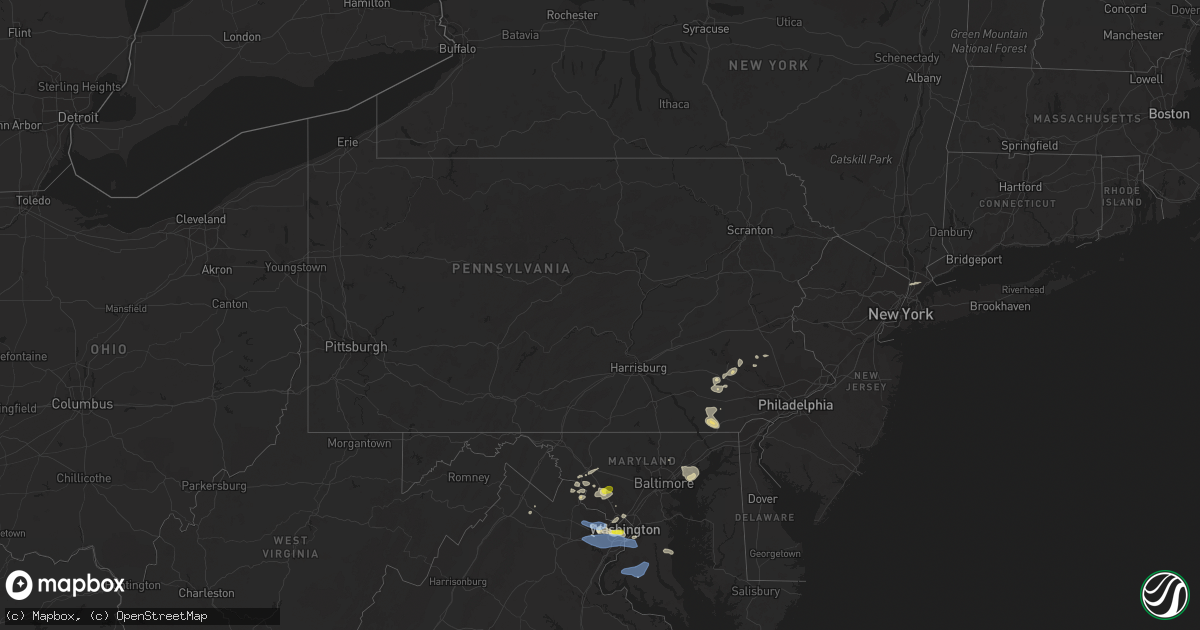
Hail Map in Pennsylvania on May 22, 2022
Get this storm
May 22 map
$229
one time, instant access
Download today. No call, no setup
Keep the $229
Bought the map and want the full workflow? Apply the entire $229 to a subscription within 7 days. None of it is wasted.
Every map, not just this one
This buys you this map. Subscription and you get every map we run, in the markets you choose from a few cities to whole states to nationwide. Plus real-time alerts the moment a storm fires.
Contact data
Name, contact info, occupancy, even credit band for addresses in the footprint. You go from where it hit to who to call.
Become the source they trust
Unlimited branding weather history reports on demand. You already have the documented answer ready for the property owner, and you are the one who showed up with it.
Property data and RoofTrace estimates
Pull up any address you have got, its value and the exact code rules for that jurisdiction, straight from One Click Code. Then RoofTrace estimates the squares, pitch, and roof value, priced the way you price.
Storm reports in Pennsylvania
Pennsylvania
| Date | Description |
|---|---|
| 05/22/20224:45 PM CDT | Report from mping: 3-inch tree limbs broken; power poles broken. |
| 05/22/20224:45 PM CDT | Utility poles damaged. |
| 05/22/20224:30 PM CDT | Tree down blocking geryville pike. |
| 05/22/20224:24 PM CDT | Corrects previous tstm wnd dmg report from 6 ene wakefield. Report from mping: 3-inch tree limbs broken; power poles broken. |
| 05/22/20224:12 PM CDT | Report of several large tree limbs and one tree down across a road in east coventry twp. Time estimated from radar. Report via facebook. |
| 05/22/20224:10 PM CDT | Trees down. |
| 05/22/20224:00 PM CDT | Trees and wires down. |
| 05/22/20223:45 PM CDT | Tree down across road. |
| 05/22/20223:05 PM CDT | Report from mping: trees uprooted or snapped; roof blown off. |
| 05/22/20223:05 PM CDT | Multiple trees down. |
| 05/22/20223:00 PM CDT | Several trees and wires down. |
| 05/22/20223:00 PM CDT | Enclosed 6 ft x 12 ft trailer blown into ditch. |
| 05/22/20223:00 PM CDT | Trees and wires down in vicinity of syner road and valley glen road west of steelstown. |
| 05/22/20223:00 PM CDT | Multiple trees down. |
| 05/22/20222:26 PM CDT | Trees on wires. |
| 05/22/20222:26 PM CDT | Several trees down in the watsontown area. |
| 05/22/20222:25 PM CDT | Tree on house. |
| 05/22/20222:21 PM CDT | Trees and wires down. |
| 05/22/20221:50 PM CDT | Several trees down in sunbury... Metal roof partially taken off of a building. |
| 05/22/20221:45 PM CDT | Tree reported down... Blocking sheshequin road in sheshequin township. |
| 05/22/202212:01 AM CDT | At 501 PM EDT, severe thunderstorms were located along a line extending from Honey Brook to Quarryville, moving east at 30 mph. HAZARD...60 mph wind gusts and penny size hail. SOURCE...Radar indicated. IMPACT...Expect damage to roofs, siding, and trees. Locations impacted include... Paradise, Quarryville, Gap, Churchtown, Holtwood, Intercourse, Christiana, Georgetown, Kirkwood, Buck, White Horse and Rawlinsville. |
| 05/21/202211:34 PM CDT | At 434 PM EDT, a severe thunderstorm was located over Churchtown, or 7 miles east of New Holland, moving east at 25 mph. HAZARD...60 mph wind gusts and nickel size hail. SOURCE...Radar indicated. IMPACT...Damage to roofs, siding, trees, and power lines is possible. Locations impacted include... Pottstown, Phoenixville, West Norriton, Collegeville, Royersford, Trappe, Honey Brook, Schwenksville, Elverson, New Morgan, Pughtown, Spring Mount, Valley Forge, Glenmoore, Chester Springs, Cedarville, King Of Prussia, Stowe, Spring City and Pottsgrove.This includes the following highways... Pennsylvania Turnpike between mile markers 296 and 312. Interstate 176 in Pennsylvania between mile markers 1 and 5. |
| 05/21/202211:28 PM CDT | At 428 PM EDT, a severe thunderstorm was located over New Holland, moving east at 25 mph. HAZARD...60 mph wind gusts and nickel size hail. SOURCE...Radar indicated. IMPACT...Expect damage to roofs, siding, and trees. Locations impacted include... New Holland, Terre Hill, Churchtown, Intercourse, Blue Ball, Goodville and White Horse.This includes The Pennsylvania Turnpike from mile markers 293 to 295. |
| 05/21/202211:08 PM CDT | At 408 PM EDT, severe thunderstorms were located along a line extending from near Fredericksburg to near Avon to Mount Joy, moving east at 40 mph. HAZARD...60 mph wind gusts and penny size hail. SOURCE...Radar indicated. IMPACT...Damage to roofs, siding, trees, and power lines is possible. Locations impacted include... Reading, Wyomissing, Birdsboro, Kutztown, Hamburg, Fleetwood, Sinking Spring, Laureldale, Womelsdorf, Wernersville, Robesonia, Leesport, Shoemakersville, Elverson, Bernville, Lyons, Strausstown, Lenhartsville, New Morgan and Spring Ridge.This includes the following highways... Pennsylvania Turnpike between mile markers 296 and 300. Interstate 78 in Pennsylvania between mile markers 10 and 43. Interstate 176 in Pennsylvania between mile markers 1 and 11. |
| 05/21/202211:02 PM CDT | At 401 PM EDT, severe thunderstorms were located along a line extending from Lickdale to Lawn, moving east at 35 mph. HAZARD...60 mph wind gusts and penny size hail. SOURCE...Radar indicated. IMPACT...Expect damage to roofs, siding, and trees. Locations impacted include... Lebanon, Ephrata, Elizabethtown, Lititz, Palmyra, Manheim, Annville, Cornwall, Akron, Myerstown, Denver and Campbelltown.This includes the following Interstates... The Pennsylvania Turnpike from mile markers 259 to 295. Interstate 78 from mile markers 0 to 8. Interstate 81 from mile markers 86 to 93. |
| 05/21/202210:35 PM CDT | At 335 PM EDT, severe thunderstorms were located along a line extending from Dehart Dam to Paxtonia to Lower Allen to Dillsburg, moving east at 25 mph. HAZARD...60 mph wind gusts and penny size hail. SOURCE...Radar indicated. IMPACT...Expect damage to roofs, siding, and trees. Locations impacted include... Harrisburg, Lower Allen, Hershey, Colonial Park, Progress, Middletown, Camp Hill, Palmyra, New Cumberland, Linglestown, Steelton and Annville.This includes the following Interstates... The Pennsylvania Turnpike from mile markers 235 to 259. Interstate 78 from mile markers 0 to 4. Interstate 81 from mile markers 68 to 96. Interstate 83 from mile markers 29 to 50. Interstate 283 from mile markers 0 to 2. |
| 05/21/202210:16 PM CDT | At 315 PM EDT, a severe thunderstorm was located over Carlisle, moving east at 40 mph. HAZARD...60 mph wind gusts and penny size hail. SOURCE...Radar indicated. IMPACT...Expect damage to roofs, siding, and trees. Locations impacted include... Harrisburg, Carlisle, Lower Allen, Colonial Park, Progress, Mechanicsburg, Camp Hill, New Cumberland, Linglestown, Enola, Steelton and Lemoyne.This includes the following Interstates... The Pennsylvania Turnpike from mile markers 215 to 239. Interstate 81 from mile markers 38 to 72. Interstate 83 from mile markers 40 to 50. Interstate 283 from mile markers 1 to 2. |
| 05/21/202210:00 PM CDT | At 259 PM EDT, a severe thunderstorm was located over Shermansdale, moving east at 35 mph. HAZARD...60 mph wind gusts and penny size hail. SOURCE...Radar indicated. IMPACT...Expect damage to roofs, siding, and trees. Locations impacted include... Harrisburg, Colonial Park, Linglestown, Paxtonia, Skyline View, Marysville, Duncannon, New Buffalo, Rockville, Shermansdale, Penn National Race Course and Dehart Dam.This includes Interstate 81 near mile marker 66...and from milemarkers 71 to 81. |
All States Impacted by Hail Map on May 22, 2022
Cities Impacted by Hail Map on May 22, 2022
- Dickerson, MD
- Adamstown, MD
- Hillsboro, AL
- Trinity, AL
- Moulton, AL
- Brooks, ME
- Gilbertsville, PA
- Pottstown, PA
- Morgantown, PA
- Birdsboro, PA
- Douglassville, PA
- Mohnton, PA
- Hudson, FL
- Jesup, GA
- Thorndike, ME
- Monroe, ME
- Honey Brook, PA
- Narvon, PA
- Phoenix, MD
- Glen Arm, MD
- Winn, ME
- Burlington, ME
- Springfield, ME
- Danforth, ME
- Wytopitlock, ME
- Lincoln, ME
- Orient, ME
- Lee, ME
- Claxton, GA
- Uvalda, GA
- Mount Vernon, GA
- Clayton, AL
- Gunpowder, MD
- Middle River, MD
- Hoboken, GA
- Riviera, TX
- Aberdeen Proving Ground, MD
- Boyds, MD
- Germantown, MD
- Clarksburg, MD
- Jay, ME
- Livermore Falls, ME
- Livermore, ME
- Farmington, ME
- Kents Hill, ME
- Mount Vernon, ME
- Vienna, ME
- Canton, ME
- Peach Bottom, PA
- Quarryville, PA
- Christiana, PA
- Oxford, PA
- Kirkwood, PA
- Nottingham, PA
- San Ygnacio, TX
- Bronson, FL
- Zapata, TX
- Brooklet, GA
- Falls Church, VA
- Arlington, VA
- Fort Myer, VA
- Collins, GA
- Morriston, FL
- Dunnellon, FL
- Upatoi, GA
- Columbus, GA
- Owings, MD
- Friendship, MD
- Chesapeake Beach, MD
- North Beach, MD
- Harrison, GA
- Wrightsville, GA
- Laredo, TX
- Mattawamkeag, ME
- Temple Hills, MD
- Suitland, MD
- Leesburg, VA
- Kingsville, TX
- Williston, FL
- Rockwood, ME
- Greenville Junction, ME
- Greenville, ME
- Peru, ME
- Alexandria, VA
- Premont, TX
- Boyce, VA
- Bartow, GA
- Davisboro, GA
- Corpus Christi, TX
- Belgrade, ME
- Alamo, GA
- Fort Benning, GA
- Roma, TX
- Monroe, VA
- Arrington, VA
- Big Island, VA
- Vesuvius, VA
- Amherst, VA
- Roseland, VA
- Tarrytown, GA
- Soperton, GA
- Lutz, FL
- McRae Helena, GA
- Gap, PA
- Tuckahoe, NY
- Eastchester, NY
- Yonkers, NY
- Scarsdale, NY
- White Post, VA
- Millen, GA
- Fort Stewart, GA
- New Rochelle, NY
- Sylvania, GA
- Rocky Ford, GA
- Bell, FL
- Trenton, FL
- Rockville, MD
- Vienna, VA
- Fairfax, VA
- Oakton, VA
- Chiefland, FL
- Aiken, SC
- Jackson, SC
- New Ellenton, SC
- Lumber City, GA
- East Earl, PA
- New Holland, PA
- Bethesda, MD
- McLean, VA
- Chevy Chase, MD
- Glen Echo, MD
- Cabin John, MD
- Harmony, ME
- Terre Hill, PA
- Oakland, ME
- Inglis, FL
- Barto, PA
- Bechtelsville, PA
- Frederick, MD
- Jefferson, MD
- Lyons, GA
- Lovettsville, VA
- Point Of Rocks, MD
- Tuscarora, MD
- Vidalia, GA
- Dexter, ME
- Cambridge, ME
- Newington, GA
- Statesboro, GA
- Unity, ME
- Albion, ME
- Troy, ME
- Rhine, GA
- Eastman, GA
- Swainsboro, GA
- Sumner, ME
- Buckfield, ME
- Bryant Pond, ME
- Greenwood, ME
- Bethel, ME
- Dixfield, ME
- Savannah, GA
- Joppa, MD
- Kingsville, MD
- White Marsh, MD
- Edgewood, MD
- Denver, PA
- Kinzers, PA
- New Market, MD
- Bishop, TX
- Ludowici, GA
- Oley, PA
- Boyertown, PA
- Atglen, PA
- Herndon, VA
- Reston, VA
- Reidsville, GA
- Milan, GA
- Falfurrias, TX
- Waycross, GA
- Montgomery Village, MD
- Gaithersburg, MD
- La Plata, MD
- Ellabell, GA
- Dunn Loring, VA
- Annandale, VA
- Washington, DC
- Waterford, VA
- Richmond Hill, GA
- Green Lane, PA
- Pennsburg, PA
- Red Hill, PA
- Louisville, AL
- Silver Spring, MD
- Glennville, GA
- Appomattox, VA
- Damascus, MD
- Eufaula, AL
- Midway, AL
- Becket, MA
- Worthington, MA
- Huntington, MA
- Williamsburg, MA
- Chester, MA
- West Chesterfield, MA
- Cummington, MA
- Chesterfield, MA
- Middlefield, MA
- Hinsdale, MA
- Belgrade Lakes, ME
- Sterling, VA
- Chantilly, VA
- Fairfax Station, VA
- Lothian, MD
- Centreville, VA
- Clifton, VA
- Manassas, VA
- Brandywine, MD
- Springfield, VA
- Upper Marlboro, MD
- Clinton, MD
- Andrews Air Force Base, MD
- Fort Washington, MD
- Cheltenham, MD
- Burke, VA
- Oxon Hill, MD
- Hughesville, MD
- Bryantown, MD
- Pomfret, MD
- Port Tobacco, MD
- Waldorf, MD
- White Plains, MD
- Greenfield, NH
- Francestown, NH
- Weare, NH
- New Boston, NH
- Clyo, GA
- Guyton, GA
- Springfield, GA


