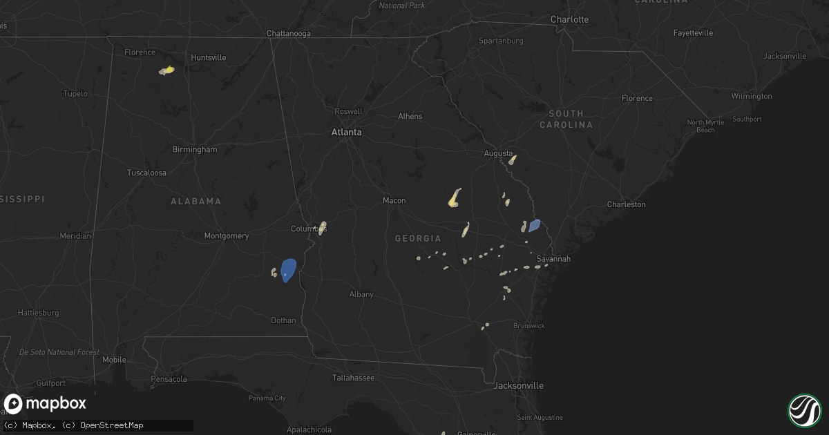
Hail Map in Georgia on May 22, 2022
Get this storm
May 22 map
$229
one time, instant access
Download today. No call, no setup
Keep the $229
Bought the map and want the full workflow? Apply the entire $229 to a subscription within 7 days. None of it is wasted.
Every map, not just this one
This buys you this map. Subscription and you get every map we run, in the markets you choose from a few cities to whole states to nationwide. Plus real-time alerts the moment a storm fires.
Contact data
Name, contact info, occupancy, even credit band for addresses in the footprint. You go from where it hit to who to call.
Become the source they trust
Unlimited branding weather history reports on demand. You already have the documented answer ready for the property owner, and you are the one who showed up with it.
Property data and RoofTrace estimates
Pull up any address you have got, its value and the exact code rules for that jurisdiction, straight from One Click Code. Then RoofTrace estimates the squares, pitch, and roof value, priced the way you price.
Storm reports in Georgia
Georgia
| Date | Description |
|---|---|
| 05/22/20225:49 PM CDT | Tree down on roberts bridge road. Time estimated by radar. |
| 05/22/20224:42 PM CDT | Two trees down on clyo-kildare road. Time estimated by radar |
| 05/22/20224:39 PM CDT | Several trees down along highway 21 near the screven county/effingham county line. Time estimated from radar. |
| 05/22/20224:36 PM CDT | Trees down and blocking the roadway on oliver kildare road between pryor road and simpson town road. Report received via twitter. |
| 05/22/20224:22 PM CDT | Trees down and blocking the roadway on ivanhoe road between hw-119 and mud road. Report received via twitter. |
| 05/22/20223:35 PM CDT | Large tree down on d anderson road. Time estimated by radar. |
| 05/22/20223:35 PM CDT | Several trees down along a 4-mile stretch of nevils daisy road and daisy nevils highway. Time estimated by radar. |
| 05/22/20223:32 PM CDT | Tree down and blocking the southbound lane of ga-169 in between james o waters road and us-301. Time estimated by radar. |
| 05/22/20223:24 PM CDT | Tree down near the intersection of kennedy bridge road and old anderson church road. Time estimated by radar. |
| 05/22/20223:22 PM CDT | Tree down on red clay road. Time estimated by radar. |
| 05/22/20221:18 PM CDT | Trees and power lines down in albany... Generally on the west side of town. |
| 05/22/202212:26 PM CDT | One tree down near the clay county line. |
| 05/22/202212:20 PM CDT | 8 trees down and 1 powerline down across clay county. |
| 05/22/20227:30 AM CDT | At 1229 PM CDT, a severe thunderstorm was located near Hawkinsville, or 8 miles northwest of Eufaula, moving north at 50 mph. HAZARD...60 mph wind gusts and quarter size hail. SOURCE...Radar indicated. IMPACT...Hail damage to vehicles is expected. Expect wind damage to roofs, siding, and trees. Locations impacted include... Phenix City, Hurtsboro, Hawkinsville, Russell County Sports Complex, Uchee, Spring Hill, Seale, Comer, Ladonia, Lakepoint Resort State Park, Batesville, Twin Springs, Rutherford, Hatchechubbe, Uchee Creek, Fort Mitchell, Ladonia Sports Complex, Fort Mitchell Activity Center, Carter Acres and Phenix Drag Strip. |
| 05/22/20226:55 AM CDT | At 1155 AM CDT, a severe thunderstorm was located 10 miles east of Ozark, moving north at 50 mph. HAZARD...60 mph wind gusts. SOURCE...Radar indicated. IMPACT...Expect damage to roofs, siding, and trees. Locations impacted include... Eufaula, Clayton, Blue Springs, Tyler Crossroads, Gaino, Barbour County Public Lake Dam, Blue Springs State Park, Osco, Texasville, Richards Crossroads, White Oak, Millers Ford, Batesville, Clayton Municipal Airport, Lugo and Baker Hill. |
| 05/22/20221:37 AM CDT | At 636 PM EDT, a severe thunderstorm was located near Woodcliff, moving northeast at 40 mph. HAZARD...60 mph wind gusts and quarter size hail. SOURCE...Radar indicated. IMPACT...Minor hail damage to vehicles is possible. Expect wind damage to trees and powerlines. Locations impacted include: Hiltonia, Woodcliff, Millhaven, Burtons Ferry Landing and Hilltonia. |
| 05/22/20221:24 AM CDT | At 624 PM EDT, a severe thunderstorm was located near Stellaville, or 8 miles northeast of Louisville, moving northeast at 50 mph. HAZARD...60 mph wind gusts and quarter size hail. SOURCE...Radar indicated. IMPACT...Hail damage to vehicles is expected. Expect wind damage to roofs, siding, and trees. Locations impacted include... Louisville, Wrens, Stapleton, Matthews, Stellaville and Stapletons Crossroads. |
| 05/22/202212:35 AM CDT | At 534 PM EDT, a severe thunderstorm was located over Donovan, or near Wrightsville, moving northeast at 15 mph. HAZARD...60 mph wind gusts and quarter size hail. SOURCE...Radar indicated. IMPACT...Hail damage to vehicles is expected. Expect wind damage to roofs, siding, and trees. Locations impacted include... Wrightsville, Wadley, Davisboro, Harrison, Bartow, Riddleville, Moxley, Donovan, New Home and Pringle. |
| 05/21/202211:52 PM CDT | At 451 PM EDT, a severe thunderstorm was located over Alamo, moving east at 25 mph. HAZARD...60 mph wind gusts and quarter size hail. SOURCE...Radar indicated. IMPACT...Hail damage to vehicles is expected. Expect wind damage to roofs, siding, and trees. Locations impacted include... Alamo, Mount Vernon, Glenwood, Ailey, Scotland, Higgston, Alston, Landsburg and Little Ocmulgee State Park. |
| 05/21/202211:43 PM CDT | At 443 PM EDT, severe thunderstorms were located along a line extending from near Register to near Nevils to near Daisy, moving east at 25 mph. HAZARD...60 mph wind gusts and penny size hail. SOURCE...Radar indicated. IMPACT...Expect damage to trees and powerlines. Locations impacted include: Pembroke, Brooklet, Daisy, Nevils, Denmark, Bay, Groveland and Stilson.This warning includes I-16 between mile markers 115 and 138. |
| 05/21/202211:37 PM CDT | At 437 PM EDT, a severe thunderstorm was located over Gillis Springs, or 8 miles northeast of Soperton, moving northeast at 25 mph. HAZARD...60 mph wind gusts and quarter size hail. SOURCE...Radar indicated. IMPACT...Hail damage to vehicles is expected. Expect wind damage to roofs, siding, and trees. Locations impacted include... Swainsboro, Oak Park, Nunez, Norristown Junction, Covena, Lexsy, Norristown, Zaidee and Gillis Springs. |
| 05/21/202211:11 PM CDT | At 411 PM EDT, a severe thunderstorm was located over Five Points, or 7 miles south of Eastman, moving northeast at 35 mph. HAZARD...60 mph wind gusts and quarter size hail. SOURCE...Radar indicated. IMPACT...Hail damage to vehicles is expected. Expect wind damage to roofs, siding, and trees. Locations impacted include... McRae, Eastman, Helena, Milan, Rhine, Chauncey, Union, Jay Bird Springs, Five Points, Achord and Godwinsville. |
| 05/21/202210:51 PM CDT | At 350 PM EDT, a severe thunderstorm was located near Gordonia Altamaha State Park, moving east at 25 mph. HAZARD...60 mph wind gusts and penny size hail. SOURCE...Radar indicated. IMPACT...Expect damage to trees and powerlines. Locations impacted include: Reidsville, Collins, Manassas and Gordonia Altamaha State Park. |
| 05/21/202210:29 PM CDT | At 329 PM EDT, a severe thunderstorm was located over Uvalda, or 10 miles northwest of Plant Hatch, moving northeast at 20 mph. HAZARD...60 mph wind gusts and quarter size hail. SOURCE...Radar indicated. IMPACT...Hail damage to vehicles is expected. Expect wind damage to roofs, siding, and trees. Locations impacted include... Lyons, Vidalia, Uvalda, Santa Claus, Alston, Center, Toombs Central, Ohoopee, New Branch, Ponderosa, McNatt Falls, South Thompson, English Eddy, Grays Landing, Rock Springs, Cedar Crossing, Johnson Corner and Charlotteville. |
| 05/21/20229:17 PM CDT | At 217 PM EDT, severe thunderstorms were located along a line extending from near Weston to 6 miles west of Leesburg, moving northeast at 40 mph. HAZARD...60 mph wind gusts and penny size hail. SOURCE...Radar indicated. IMPACT...Expect damage to roofs, siding, and trees. Locations impacted include... Dawson, Smithville, Sasser, Bronwood, Parrott, Bridges Crossroad, Oakville, Chambliss, Olivers Mill and Yeomans. |
| 05/21/20229:03 PM CDT | At 203 PM EDT, severe thunderstorms were located along a line extending from 9 miles west of Albany to 11 miles southwest of Newton, moving northeast at 15 mph. HAZARD...60 mph wind gusts and penny size hail. SOURCE...Radar indicated. IMPACT...Expect damage to roofs, siding, and trees. Locations impacted include... Newton, Leesburg, Albany, Baconton, East Albany, Turner City, Walker, Stocks, Radium Springs, Red Store Crossroads, Forrester, Lockett Crossing, South Albany, Southwest Ga Regional A/P, Palmyra, Century, Jordan Place, Ducker, Starksville and Byne Crossroads. |
| 05/21/20228:35 PM CDT | At 135 PM EDT, severe thunderstorms were located along a line extending from near Cuthbert to near Leary, moving north at 40 mph. HAZARD...60 mph wind gusts and penny size hail. SOURCE...Radar indicated. IMPACT...Expect damage to roofs, siding, and trees. Locations impacted include... Morgan, Dawson, Cuthbert, Edison, Arlington, Shellman, Leary, Sasser, Bronwood, Parrott, Iveys Mill, Carnegie, Holt, Randolph Co A/p, Clarks Mill, Dawson Municipal A/P, Aycock Mill, Chambliss, Olivers Mill and Martins Crossroads. |
All States Impacted by Hail Map on May 22, 2022
Cities Impacted by Hail Map on May 22, 2022
- Dickerson, MD
- Adamstown, MD
- Hillsboro, AL
- Trinity, AL
- Moulton, AL
- Brooks, ME
- Gilbertsville, PA
- Pottstown, PA
- Morgantown, PA
- Birdsboro, PA
- Douglassville, PA
- Mohnton, PA
- Hudson, FL
- Jesup, GA
- Thorndike, ME
- Monroe, ME
- Honey Brook, PA
- Narvon, PA
- Phoenix, MD
- Glen Arm, MD
- Winn, ME
- Burlington, ME
- Springfield, ME
- Danforth, ME
- Wytopitlock, ME
- Lincoln, ME
- Orient, ME
- Lee, ME
- Claxton, GA
- Uvalda, GA
- Mount Vernon, GA
- Clayton, AL
- Gunpowder, MD
- Middle River, MD
- Hoboken, GA
- Riviera, TX
- Aberdeen Proving Ground, MD
- Boyds, MD
- Germantown, MD
- Clarksburg, MD
- Jay, ME
- Livermore Falls, ME
- Livermore, ME
- Farmington, ME
- Kents Hill, ME
- Mount Vernon, ME
- Vienna, ME
- Canton, ME
- Peach Bottom, PA
- Quarryville, PA
- Christiana, PA
- Oxford, PA
- Kirkwood, PA
- Nottingham, PA
- San Ygnacio, TX
- Bronson, FL
- Zapata, TX
- Brooklet, GA
- Falls Church, VA
- Arlington, VA
- Fort Myer, VA
- Collins, GA
- Morriston, FL
- Dunnellon, FL
- Upatoi, GA
- Columbus, GA
- Owings, MD
- Friendship, MD
- Chesapeake Beach, MD
- North Beach, MD
- Harrison, GA
- Wrightsville, GA
- Laredo, TX
- Mattawamkeag, ME
- Temple Hills, MD
- Suitland, MD
- Leesburg, VA
- Kingsville, TX
- Williston, FL
- Rockwood, ME
- Greenville Junction, ME
- Greenville, ME
- Peru, ME
- Alexandria, VA
- Premont, TX
- Boyce, VA
- Bartow, GA
- Davisboro, GA
- Corpus Christi, TX
- Belgrade, ME
- Alamo, GA
- Fort Benning, GA
- Roma, TX
- Monroe, VA
- Arrington, VA
- Big Island, VA
- Vesuvius, VA
- Amherst, VA
- Roseland, VA
- Tarrytown, GA
- Soperton, GA
- Lutz, FL
- McRae Helena, GA
- Gap, PA
- Tuckahoe, NY
- Eastchester, NY
- Yonkers, NY
- Scarsdale, NY
- White Post, VA
- Millen, GA
- Fort Stewart, GA
- New Rochelle, NY
- Sylvania, GA
- Rocky Ford, GA
- Bell, FL
- Trenton, FL
- Rockville, MD
- Vienna, VA
- Fairfax, VA
- Oakton, VA
- Chiefland, FL
- Aiken, SC
- Jackson, SC
- New Ellenton, SC
- Lumber City, GA
- East Earl, PA
- New Holland, PA
- Bethesda, MD
- McLean, VA
- Chevy Chase, MD
- Glen Echo, MD
- Cabin John, MD
- Harmony, ME
- Terre Hill, PA
- Oakland, ME
- Inglis, FL
- Barto, PA
- Bechtelsville, PA
- Frederick, MD
- Jefferson, MD
- Lyons, GA
- Lovettsville, VA
- Point Of Rocks, MD
- Tuscarora, MD
- Vidalia, GA
- Dexter, ME
- Cambridge, ME
- Newington, GA
- Statesboro, GA
- Unity, ME
- Albion, ME
- Troy, ME
- Rhine, GA
- Eastman, GA
- Swainsboro, GA
- Sumner, ME
- Buckfield, ME
- Bryant Pond, ME
- Greenwood, ME
- Bethel, ME
- Dixfield, ME
- Savannah, GA
- Joppa, MD
- Kingsville, MD
- White Marsh, MD
- Edgewood, MD
- Denver, PA
- Kinzers, PA
- New Market, MD
- Bishop, TX
- Ludowici, GA
- Oley, PA
- Boyertown, PA
- Atglen, PA
- Herndon, VA
- Reston, VA
- Reidsville, GA
- Milan, GA
- Falfurrias, TX
- Waycross, GA
- Montgomery Village, MD
- Gaithersburg, MD
- La Plata, MD
- Ellabell, GA
- Dunn Loring, VA
- Annandale, VA
- Washington, DC
- Waterford, VA
- Richmond Hill, GA
- Green Lane, PA
- Pennsburg, PA
- Red Hill, PA
- Louisville, AL
- Silver Spring, MD
- Glennville, GA
- Appomattox, VA
- Damascus, MD
- Eufaula, AL
- Midway, AL
- Becket, MA
- Worthington, MA
- Huntington, MA
- Williamsburg, MA
- Chester, MA
- West Chesterfield, MA
- Cummington, MA
- Chesterfield, MA
- Middlefield, MA
- Hinsdale, MA
- Belgrade Lakes, ME
- Sterling, VA
- Chantilly, VA
- Fairfax Station, VA
- Lothian, MD
- Centreville, VA
- Clifton, VA
- Manassas, VA
- Brandywine, MD
- Springfield, VA
- Upper Marlboro, MD
- Clinton, MD
- Andrews Air Force Base, MD
- Fort Washington, MD
- Cheltenham, MD
- Burke, VA
- Oxon Hill, MD
- Hughesville, MD
- Bryantown, MD
- Pomfret, MD
- Port Tobacco, MD
- Waldorf, MD
- White Plains, MD
- Greenfield, NH
- Francestown, NH
- Weare, NH
- New Boston, NH
- Clyo, GA
- Guyton, GA
- Springfield, GA


