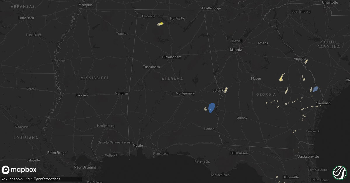
Hail Map in Alabama on May 22, 2022
Get this storm
May 22 map
$229
one time, instant access
Download today. No call, no setup
Keep the $229
Bought the map and want the full workflow? Apply the entire $229 to a subscription within 7 days. None of it is wasted.
Every map, not just this one
This buys you this map. Subscription and you get every map we run, in the markets you choose from a few cities to whole states to nationwide. Plus real-time alerts the moment a storm fires.
Contact data
Name, contact info, occupancy, even credit band for addresses in the footprint. You go from where it hit to who to call.
Become the source they trust
Unlimited branding weather history reports on demand. You already have the documented answer ready for the property owner, and you are the one who showed up with it.
Property data and RoofTrace estimates
Pull up any address you have got, its value and the exact code rules for that jurisdiction, straight from One Click Code. Then RoofTrace estimates the squares, pitch, and roof value, priced the way you price.
Storm reports in Alabama
Alabama
| Date | Description |
|---|---|
| 05/22/20224:57 PM CDT | Tree down near the intersection of 3rd ave se and 4th st se in decatur. |
| 05/22/20224:31 PM CDT | Quarter size hail was reported at east lawrence elementary school. |
| 05/22/20224:22 PM CDT | 10 to 12 trees were reported down on cr 434 to cr 214 along a stretch 2 miles east of this location near cr 214. |
| 05/22/20221:32 PM CDT | Tree down along cr 36. |
| 05/22/20221:20 PM CDT | Roof damage to a couple businesses near the intersection of opelika rd and crawford rd. |
| 05/22/20221:07 PM CDT | Trees down on power lines along owens rd. |
| 05/22/202212:52 PM CDT | Trees down along hwy 110. |
| 05/22/202212:45 PM CDT | Trees down along hwy 239. |
| 05/22/202212:30 PM CDT | Via 911 center... Many reports of trees down across portions of barbour county. Details to come. |
| 05/22/202212:25 PM CDT | Multiple trees down in troy... Including on franklin dr at lawson dr... And on cr 5511... And smart rd. |
| 05/22/202212:18 PM CDT | Trees reported down in brundidge... Including along cr 4430 and on galloway rd at pierson st. |
| 05/22/202212:03 PM CDT | Big swingset blown over near capps. Social media report. |
| 05/22/202211:57 AM CDT | Estimated 60+ mph gust in headland. Report via social media. |
| 05/22/202211:55 AM CDT | Trees down... Blocking roadway. |
| 05/22/202211:55 AM CDT | Trees down near hwy 231 and bivins dr... Blocking a roadway. |
| 05/22/202211:50 AM CDT | Trees and powerlines down across road in henry county in the capps area. |
| 05/22/202211:47 AM CDT | Tree down on power line along skipperville road... Closing the road. |
| 05/22/202211:32 AM CDT | Tree down near midtown motors in midland city. Report via social media. |
| 05/22/202211:30 AM CDT | A tree fell on a powerline near denton road and junaluska avenue in north dothan. Closure of denton road. Courtesy wdhn news facebook. |
| 05/22/202211:25 AM CDT | Multiple trees and powerlines down on the east side of dothan near the ashford and columbia areas. Structure damage in the area and roof off of one business near the fa |
| 05/22/20227:56 AM CDT | At 1255 PM EDT/1155 AM CDT/, severe thunderstorms were located along a line extending from 8 miles northeast of Ozark to 7 miles north of Columbia, moving northeast at 50 mph. HAZARD...60 mph wind gusts and penny size hail. SOURCE...Radar indicated. IMPACT...Expect damage to roofs, siding, and trees. Locations impacted include... Abbeville, Fort Gaines, Georgetown, Ozark, Cuthbert, Headland, Fort Rucker, Ariton, Newville, Bellville, Haleburg, Shorterville, Wire Bridge, Hayes, Watson Crossroads, Scottsboro Crossroads, Ricks Place, Pecan, Ewell and Dale County Lake. |
| 05/22/20227:37 AM CDT | At 1236 PM CDT, a severe thunderstorm was located near Beans Crossroads, or 11 miles south of Union Springs, moving north at 35 mph. HAZARD...60 mph wind gusts and nickel size hail. SOURCE...Radar indicated. IMPACT...Expect damage to roofs, siding, and trees. Locations impacted include... Tuskegee, Union Springs, Midway, Shorter, Pine Level, Aberfoil, Franklin Field, Lake Tuskegee, Beans Crossroads, Guerryton, Shopton, Davisville, Waugh, Liverpool, Hardaway, Tysonville, Victoryland, Warriorstand, High Ridge and Fort Davis. |
| 05/22/20227:05 AM CDT | At 1205 PM CDT, a severe thunderstorm was located over Brundidge, moving north at 45 mph. HAZARD...60 mph wind gusts and quarter size hail. SOURCE...Radar indicated. IMPACT...Hail damage to vehicles is expected. Expect wind damage to roofs, siding, and trees. Locations impacted include... Troy, Brundidge, Clio, Louisville, Banks, Pickett, Beans Crossroads, Linwood, Boot Hill, Doster, Antioch, Troy Municipal Airport, Troy University, Tennille, Perote, Josie, Mount Andrew, Tanyard, Hamilton Crossroads and Monticello. |
| 05/22/20226:27 AM CDT | At 1126 AM CDT, severe thunderstorms were located along a line extending from 6 miles southeast of Daleville to near Taylor, moving northeast at 45 mph. HAZARD...60 mph wind gusts and penny size hail. SOURCE...Radar indicated. IMPACT...Expect damage to roofs, siding, and trees. Locations impacted include... Headland, Dothan, Ozark, Fort Rucker, Taylor, Midland City, Kinsey, Cowarts, Newton, Webb, Pinckard, Malvern, Rehobeth, Grimes, Newville, Napier Field, Haleburg, Memphis, Waterford and Wilson Mill. |
| 05/21/202211:42 PM CDT | At 442 PM CDT, a severe thunderstorm was located over Trinity, or near Decatur, moving northeast at 25 mph. HAZARD...60 mph wind gusts and quarter size hail. SOURCE...Radar indicated. IMPACT...Hail damage to vehicles is expected. Expect wind damage to roofs, siding, and trees. Locations impacted include... Decatur, Madison, Athens, Trinity, Tanner, Huntsville International Airport, Mooresville, Belle Mina, French Mill and Capshaw. |
| 05/21/202211:21 PM CDT | At 420 PM CDT, a severe thunderstorm was located near Moulton, moving northeast at 15 mph. HAZARD...60 mph wind gusts and quarter size hail. SOURCE...Radar indicated. IMPACT...Hail damage to vehicles is expected. Expect wind damage to roofs, siding, and trees. Locations impacted include... Decatur, Moulton, Trinity, Hillsboro, Chalybeate Springs, Caddo and Wheeler. |
| 05/21/20228:44 PM CDT | At 144 PM EDT, severe thunderstorms were located along a line extending from 6 miles east of Lakepoint Resort State Park to 11 miles south of Lumpkin to near Cuthbert, moving northeast at 40 mph. HAZARD...60 mph wind gusts and penny size hail. SOURCE...Radar indicated. IMPACT...Expect damage to roofs, siding, and trees. Locations impacted include... Georgetown, Springvale Station, Wire Bridge, Hatcher, Morris, Peterson Hill, Coles, Crossroads and Springvale. |
All States Impacted by Hail Map on May 22, 2022
Cities Impacted by Hail Map on May 22, 2022
- Dickerson, MD
- Adamstown, MD
- Hillsboro, AL
- Trinity, AL
- Moulton, AL
- Brooks, ME
- Gilbertsville, PA
- Pottstown, PA
- Morgantown, PA
- Birdsboro, PA
- Douglassville, PA
- Mohnton, PA
- Hudson, FL
- Jesup, GA
- Thorndike, ME
- Monroe, ME
- Honey Brook, PA
- Narvon, PA
- Phoenix, MD
- Glen Arm, MD
- Winn, ME
- Burlington, ME
- Springfield, ME
- Danforth, ME
- Wytopitlock, ME
- Lincoln, ME
- Orient, ME
- Lee, ME
- Claxton, GA
- Uvalda, GA
- Mount Vernon, GA
- Clayton, AL
- Gunpowder, MD
- Middle River, MD
- Hoboken, GA
- Riviera, TX
- Aberdeen Proving Ground, MD
- Boyds, MD
- Germantown, MD
- Clarksburg, MD
- Jay, ME
- Livermore Falls, ME
- Livermore, ME
- Farmington, ME
- Kents Hill, ME
- Mount Vernon, ME
- Vienna, ME
- Canton, ME
- Peach Bottom, PA
- Quarryville, PA
- Christiana, PA
- Oxford, PA
- Kirkwood, PA
- Nottingham, PA
- San Ygnacio, TX
- Bronson, FL
- Zapata, TX
- Brooklet, GA
- Falls Church, VA
- Arlington, VA
- Fort Myer, VA
- Collins, GA
- Morriston, FL
- Dunnellon, FL
- Upatoi, GA
- Columbus, GA
- Owings, MD
- Friendship, MD
- Chesapeake Beach, MD
- North Beach, MD
- Harrison, GA
- Wrightsville, GA
- Laredo, TX
- Mattawamkeag, ME
- Temple Hills, MD
- Suitland, MD
- Leesburg, VA
- Kingsville, TX
- Williston, FL
- Rockwood, ME
- Greenville Junction, ME
- Greenville, ME
- Peru, ME
- Alexandria, VA
- Premont, TX
- Boyce, VA
- Bartow, GA
- Davisboro, GA
- Corpus Christi, TX
- Belgrade, ME
- Alamo, GA
- Fort Benning, GA
- Roma, TX
- Monroe, VA
- Arrington, VA
- Big Island, VA
- Vesuvius, VA
- Amherst, VA
- Roseland, VA
- Tarrytown, GA
- Soperton, GA
- Lutz, FL
- McRae Helena, GA
- Gap, PA
- Tuckahoe, NY
- Eastchester, NY
- Yonkers, NY
- Scarsdale, NY
- White Post, VA
- Millen, GA
- Fort Stewart, GA
- New Rochelle, NY
- Sylvania, GA
- Rocky Ford, GA
- Bell, FL
- Trenton, FL
- Rockville, MD
- Vienna, VA
- Fairfax, VA
- Oakton, VA
- Chiefland, FL
- Aiken, SC
- Jackson, SC
- New Ellenton, SC
- Lumber City, GA
- East Earl, PA
- New Holland, PA
- Bethesda, MD
- McLean, VA
- Chevy Chase, MD
- Glen Echo, MD
- Cabin John, MD
- Harmony, ME
- Terre Hill, PA
- Oakland, ME
- Inglis, FL
- Barto, PA
- Bechtelsville, PA
- Frederick, MD
- Jefferson, MD
- Lyons, GA
- Lovettsville, VA
- Point Of Rocks, MD
- Tuscarora, MD
- Vidalia, GA
- Dexter, ME
- Cambridge, ME
- Newington, GA
- Statesboro, GA
- Unity, ME
- Albion, ME
- Troy, ME
- Rhine, GA
- Eastman, GA
- Swainsboro, GA
- Sumner, ME
- Buckfield, ME
- Bryant Pond, ME
- Greenwood, ME
- Bethel, ME
- Dixfield, ME
- Savannah, GA
- Joppa, MD
- Kingsville, MD
- White Marsh, MD
- Edgewood, MD
- Denver, PA
- Kinzers, PA
- New Market, MD
- Bishop, TX
- Ludowici, GA
- Oley, PA
- Boyertown, PA
- Atglen, PA
- Herndon, VA
- Reston, VA
- Reidsville, GA
- Milan, GA
- Falfurrias, TX
- Waycross, GA
- Montgomery Village, MD
- Gaithersburg, MD
- La Plata, MD
- Ellabell, GA
- Dunn Loring, VA
- Annandale, VA
- Washington, DC
- Waterford, VA
- Richmond Hill, GA
- Green Lane, PA
- Pennsburg, PA
- Red Hill, PA
- Louisville, AL
- Silver Spring, MD
- Glennville, GA
- Appomattox, VA
- Damascus, MD
- Eufaula, AL
- Midway, AL
- Becket, MA
- Worthington, MA
- Huntington, MA
- Williamsburg, MA
- Chester, MA
- West Chesterfield, MA
- Cummington, MA
- Chesterfield, MA
- Middlefield, MA
- Hinsdale, MA
- Belgrade Lakes, ME
- Sterling, VA
- Chantilly, VA
- Fairfax Station, VA
- Lothian, MD
- Centreville, VA
- Clifton, VA
- Manassas, VA
- Brandywine, MD
- Springfield, VA
- Upper Marlboro, MD
- Clinton, MD
- Andrews Air Force Base, MD
- Fort Washington, MD
- Cheltenham, MD
- Burke, VA
- Oxon Hill, MD
- Hughesville, MD
- Bryantown, MD
- Pomfret, MD
- Port Tobacco, MD
- Waldorf, MD
- White Plains, MD
- Greenfield, NH
- Francestown, NH
- Weare, NH
- New Boston, NH
- Clyo, GA
- Guyton, GA
- Springfield, GA


