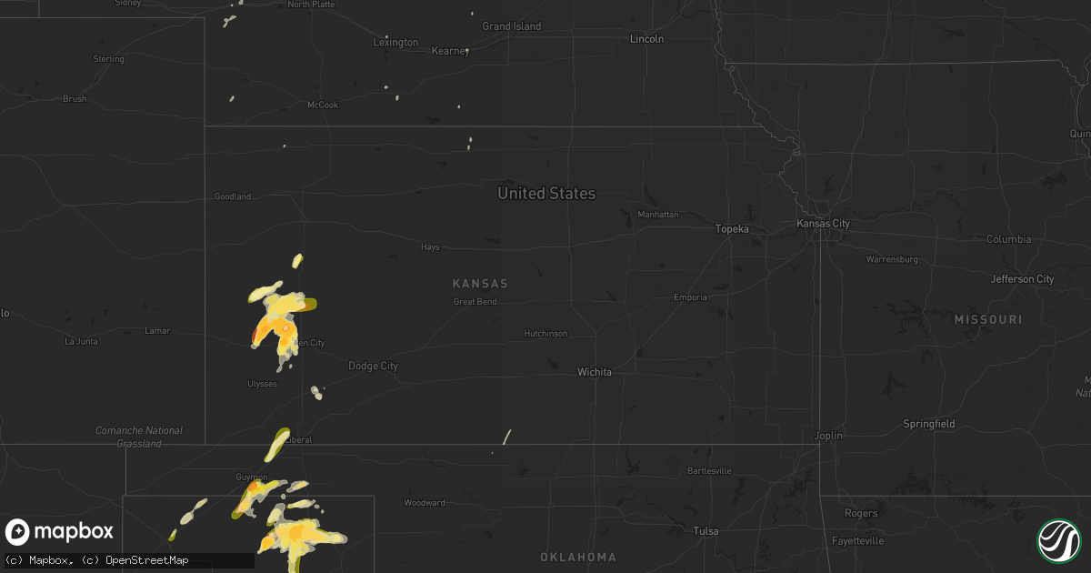
Hail Map in Kansas on May 22, 2016
Get this storm
May 22 map
$229
one time, instant access
Download today. No call, no setup
Keep the $229
Bought the map and want the full workflow? Apply the entire $229 to a subscription within 7 days. None of it is wasted.
Every map, not just this one
This buys you this map. Subscription and you get every map we run, in the markets you choose from a few cities to whole states to nationwide. Plus real-time alerts the moment a storm fires.
Contact data
Name, contact info, occupancy, even credit band for addresses in the footprint. You go from where it hit to who to call.
Become the source they trust
Unlimited branding weather history reports on demand. You already have the documented answer ready for the property owner, and you are the one who showed up with it.
Property data and RoofTrace estimates
Pull up any address you have got, its value and the exact code rules for that jurisdiction, straight from One Click Code. Then RoofTrace estimates the squares, pitch, and roof value, priced the way you price.
Storm reports in Kansas
Kansas
| Date | Description |
|---|---|
| 05/22/20166:50 PM CDT | A local report indicates 1.00 inch wind near 1 ESE HOLCOMB |
| 05/22/20166:22 PM CDT | A local report indicates 1.50 inch wind near 1 WNW DEERFIELD |
| 05/22/20166:18 PM CDT | A local report indicates 1.75 inch wind near 1 SW DEERFIELD |
| 05/22/20166:08 PM CDT | A local report indicates 1.25 inch wind near 4 S DEERFIELD |
| 05/22/20166:07 PM CDT | A local report indicates 1.00 inch wind near 5 SSW DEERFIELD |
| 05/21/20169:48 PM CDT | A local report indicates 1.25 inch wind near 1 SE LEOTI |
| 05/21/20168:30 PM CDT | Large tornado on the ground...approx. One half mile wide wedge. |
| 05/21/20168:25 PM CDT | Large tornado on the ground...rain wrapped |
| 05/21/20168:10 PM CDT | Brief tornado reported by kwch chaser |
| 05/21/20167:42 PM CDT | Location estimated by radar |
| 05/21/20167:26 PM CDT | Large variability in size |
| 05/21/20167:17 PM CDT | A local report indicates 2.50 inch wind near 12 NW LAKIN |
| 05/21/20167:16 PM CDT | Trained spotter reported small tornado near w road. |
| 05/21/20167:13 PM CDT | A local report indicates 3.00 inch wind near 11 NNE DEERFIELD |
| 05/21/20167:13 PM CDT | The actual measured hail size was 3.5 inches. The observer posted a photo of the hail on social media. |
All States Impacted by Hail Map on May 22, 2016
Cities Impacted by Hail Map on May 22, 2016
- Platte, SD
- Kimball, SD
- White Lake, SD
- Ypsilanti, ND
- Jamestown, ND
- Gackle, ND
- Selby, SD
- Edinburg, ND
- Hamill, SD
- Stratford, TX
- Wilson, OK
- Ardmore, OK
- Lone Grove, OK
- Maxwell, NE
- Stapleton, NE
- Mission, SD
- Valentine, NE
- Lakin, KS
- Deerfield, KS
- Holcomb, KS
- Childress, TX
- Quanah, TX
- Paducah, TX
- Chillicothe, TX
- Montpelier, ND
- Kulm, ND
- Jud, ND
- Lakeview, TX
- Memphis, TX
- White River, SD
- Big Spring, TX
- Clarendon, TX
- Lorenzo, TX
- Colome, SD
- Sparks, NE
- Sargent, NE
- Norris, SD
- Marion, SC
- Parmelee, SD
- Mountain View, OK
- Gruver, TX
- Canadian, TX
- Stinnett, TX
- Spearman, TX
- Perryton, TX
- Miami, TX
- Pampa, TX
- Woodworth, ND
- Pingree, ND
- Walters, OK
- Grandfield, OK
- Devol, OK
- Gail, TX
- Mound City, SD
- Fredonia, ND
- Lehr, ND
- Kilgore, NE
- Cody, NE
- Nenzel, NE
- Dalhart, TX
- Winner, SD
- Hemingford, NE
- Belvidere, SD
- Crowell, TX
- Post, TX
- Herreid, SD
- Crary, ND
- Comstock, TX
- Dryden, TX
- Davidson, OK
- Binford, ND
- Cooperstown, ND
- Wood Lake, NE
- Ralls, TX
- Floydada, TX
- Henrietta, TX
- Scotland, TX
- Windthorst, TX
- Tell, TX
- Hedley, TX
- Wishek, ND
- Lakota, ND
- Garden City, TX
- Groom, TX
- White Deer, TX
- Liberal, KS
- Hugoton, KS
- Hooker, OK
- Tahoka, TX
- Odonnell, TX
- Ashley, ND
- Lenorah, TX
- Knott, TX
- Stanton, TX
- Arnold, NE
- Brady, NE
- Copeland, KS
- Sublette, KS
- Wakpala, SD
- Thedford, NE
- Altus, OK
- Atwood, KS
- Hoople, ND
- Burke, SD
- Gregory, SD
- Ravenna, NE
- Lamesa, TX
- Crosbyton, TX
- Medina, ND
- Tappen, ND
- Bowie, TX
- Jacksboro, TX
- Alvord, TX
- Chico, TX
- Sunset, TX
- Bellevue, TX
- North Platte, NE
- Reidsville, NC
- Garden City, KS
- Mchenry, ND
- New Rockford, ND
- Leoti, KS
- Lockney, TX
- Byers, TX
- Brooten, MN
- Pukwana, SD
- Vernon, TX
- Burlington, NC
- Bemidji, MN
- Matador, TX
- Flomot, TX
- Justiceburg, TX
- Tarzan, TX
- Eagle Butte, SD
- Gettysburg, SD
- Dickey, ND
- Holliday, TX
- Iowa Park, TX
- Electra, TX
- Turtle Lake, ND
- Butte, ND
- Ruso, ND
- Carrington, ND
- Glenham, SD
- Turkey, TX
- Warwick, ND
- Grace City, ND
- Ulysses, KS
- Eldorado, OK
- Gould, OK
- Whitman, NE
- Crookston, NE
- Springview, NE
- Temple, OK
- Goodrich, ND
- Wing, ND
- Guymon, OK
- Hardesty, OK
- Carnegie, OK
- Elmer, OK
- Marienthal, KS
- Scott City, KS
- Plains, KS
- Voltaire, ND
- Frederick, OK
- Claude, TX
- Lake Andes, SD
- Geddes, SD
- Ackerly, TX
- Oakley, KS
- Saint Francis, SD
- Tuthill, SD
- Port Arthur, TX
- Washburn, ND
- Underwood, ND
- Gainesville, TX
- Collinsville, TX
- Hague, ND
- Brocket, ND
- Pelican Rapids, MN
- Menahga, MN
- Hollister, OK
- Goodwell, OK
- Mizpah, MN
- Northome, MN
- Gibbon, NE
- Trail City, SD
- Sutherland, NE
- Tryon, NE
- Harrold, TX
- Dallas, SD
- Aneta, ND
- Galveston, TX
- Devers, TX
- Olustee, OK
- Odell, TX
- Tipton, OK
- Zeeland, ND
- Eureka, SD
- Artesian, SD
- Smith Center, KS
- Max, ND
- Garrison, ND
- Langdon, ND
- Alsen, ND
- Pierre, SD
- Pekin, ND
- Tolna, ND
- Balko, OK
- Roosevelt, OK
- Hobart, OK
- Reliance, SD
- Kennebec, SD
- Wellington, TX
- Tioga, TX
- Geronimo, OK
- Oxford, NE
- Hollis, OK
- Corsica, SD
- Armour, SD
- Cee Vee, TX
- Harrison, SD
- Balfour, ND
- Cozad, NE
- Duke, OK
- Muenster, TX
- Forestburg, TX
- Dawson, ND
- Stickney, SD
- Waterbury, NE
- Grafton, ND
- Edgeley, ND
- Roaring Springs, TX
- Winona, KS
- Graham, NC
- Snow Camp, NC
- Mangum, OK
- Gothenburg, NE
- Burlington, OK
- Kiowa, KS
- Hazelton, KS
- Murdo, SD
- Draper, SD
- Comstock, NE
- Glenfield, ND
- Midland, TX
- Big Lake, TX
- Glenwood, MN
- Midland, SD
- Alliance, NE
- Mills, NE
- Arthur, NE
- Ringling, OK
- Niagara, ND
- Randlett, OK
- Lankin, ND
- Hay Springs, NE
- Mercer, ND
- Chamberlain, SD
- Grant, NE
- Ogallala, NE
- Gotebo, OK
- Plankinton, SD
- Altus Afb, OK
- Berlin, ND
- Oklaunion, TX
- Headrick, OK
- Loveland, OK
- Quitaque, TX
- Spiritwood, ND
- Sanborn, ND
- Dunning, NE
- Pamplico, SC
- Long Valley, SD
- Napoleon, ND
- Scottsbluff, NE
- Gering, NE
- Mapleton, IA
- Hinton, IA
- Parks, NE
- Arapahoe, NE
- Higgins, TX
- Hyannis, NE
- Newman Grove, NE
- Villard, MN
- Sauk Centre, MN
- Liberty, TX
- Tower City, ND
- Page, ND
- Wichita Falls, TX
- Ridgeview, SD
- Battle Creek, IA
- Chatham, VA
- Lawton, ND
- Keystone, NE
- Marion, ND
- Buchanan, ND
- Tuttle, ND
- Wadena, MN
- Gresham, SC
- Crystal, ND
- Lone Wolf, OK
- Bloomington, NE
- Wagner, SD
- Litchville, ND
- Mcville, ND
- Lamoure, ND
- Fullerton, ND
- Alva, OK
- Gunter, TX
- Mobridge, SD
- Pollock, SD
- Lemoyne, NE
- Florence, SC
- Lelia Lake, TX


