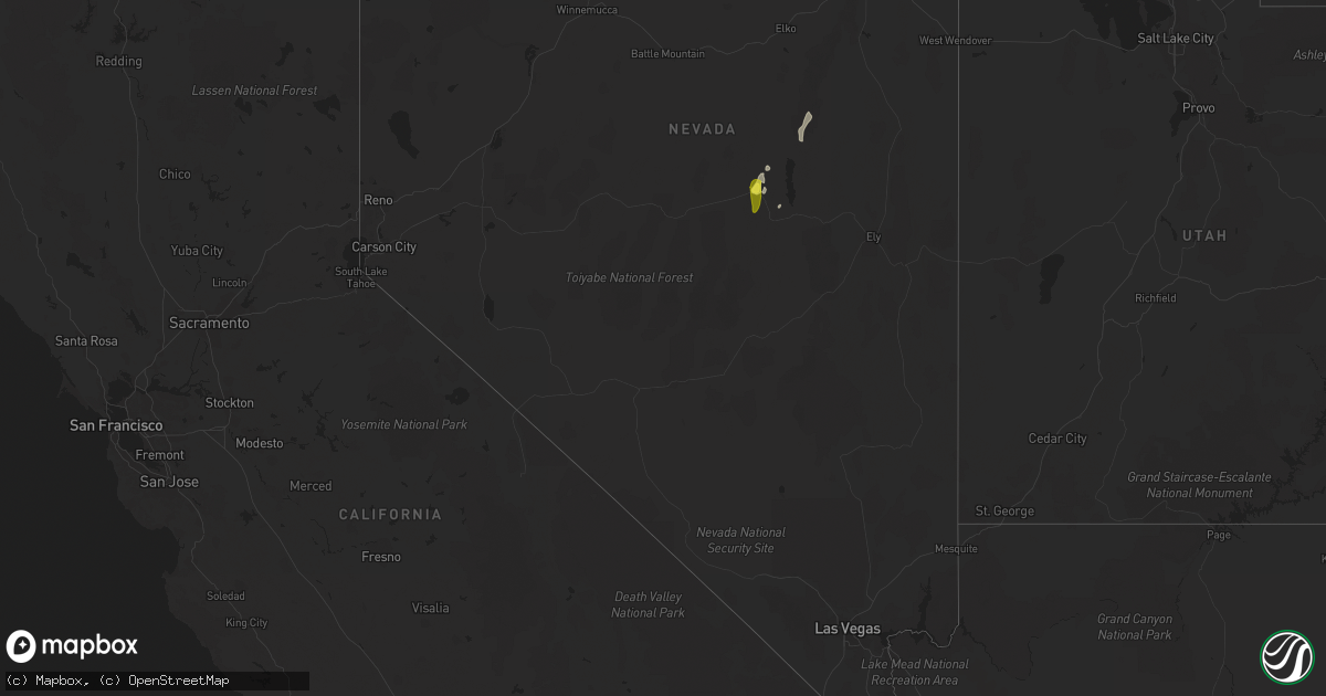
Hail Map in Nevada on May 15, 2021
Get this storm
May 15 map
$229
one time, instant access
Download today. No call, no setup
Keep the $229
Bought the map and want the full workflow? Apply the entire $229 to a subscription within 7 days. None of it is wasted.
Every map, not just this one
This buys you this map. Subscription and you get every map we run, in the markets you choose from a few cities to whole states to nationwide. Plus real-time alerts the moment a storm fires.
Contact data
Name, contact info, occupancy, even credit band for addresses in the footprint. You go from where it hit to who to call.
Become the source they trust
Unlimited branding weather history reports on demand. You already have the documented answer ready for the property owner, and you are the one who showed up with it.
Property data and RoofTrace estimates
Pull up any address you have got, its value and the exact code rules for that jurisdiction, straight from One Click Code. Then RoofTrace estimates the squares, pitch, and roof value, priced the way you price.
Storm reports in Nevada
Nevada
| Date | Description |
|---|---|
| 05/15/20216:44 PM CDT | Corrects previous tstm wnd gst report from 14 wsw pinto summit. Measured at automated station combs canyon |
| 05/15/20216:42 PM CDT | A local report indicates 1.00 inch wind near EUREKA |
| 05/15/20216:27 PM CDT | Pancake raws |
| 05/15/20213:30 PM CDT | Hail size confirmed from a picture off facebook. Also damage to windows... Homes... And vehicles were reported with some pictures provided. |
| 05/15/20213:30 PM CDT | Spotter reported large hail in diamond valley... Verified by pictures sent via email. |
| 05/14/202110:55 PM CDT | At 354 PM PDT, a severe thunderstorm was located near Ruby Lake, moving north at 25 mph. HAZARD...60 mph wind gusts and penny size hail. SOURCE...Radar indicated. IMPACT...Expect damage to roofs, siding, and trees. Locations impacted include... Ruby Lake, Harrison Pass and Franklin Lake. |
| 05/14/202110:24 PM CDT | At 323 PM PDT, a severe thunderstorm was located 10 miles southwest of Ruby Lake, moving north at 25 mph. HAZARD...60 mph wind gusts and quarter size hail. SOURCE...Radar indicated. IMPACT...Hail damage to vehicles is expected. Expect wind damage to roofs, siding, and trees. Locations impacted include... Ruby Lake, Big Bald Mountain and Overland Pass. |
| 05/14/20218:58 PM CDT | At 157 PM PDT, a cluster of severe thunderstorms was located over Diamond Valley, moving northeast at 25 mph. HAZARD...60 mph wind gusts and quarter size hail. SOURCE...Radar indicated. IMPACT...Hail damage to vehicles is expected. Expect wind damage to roofs, siding, and trees. Locations impacted include... Eureka, Diamond Valley, Eureka Airport and Newark Valley. |
| 05/14/20218:34 PM CDT | At 133 PM PDT, a severe thunderstorm was located over Eureka Airport, moving northeast at 40 mph. HAZARD...60 mph wind gusts and quarter size hail. SOURCE...Radar indicated. IMPACT...Hail damage to vehicles is expected. Expect wind damage to roofs, siding, and trees. Locations impacted include... Eureka, Pinto Summit, Diamond Valley, Eureka Airport, Newark Valley and Big Bald Mountain. |
| 05/14/20218:26 PM CDT | At 124 PM PDT, a severe thunderstorm was located near Middlegate, or 30 miles north of Gabbs, and is nearly stationary. HAZARD...60 mph wind gusts and quarter size hail. SOURCE...Radar indicated. IMPACT...Hail damage to vehicles is expected. Motorists on Highway 50 near Middlegate could encounter large hail, blinding downpours, and frequent lightning. Locations impacted include... Middlegate, Junction U.S 50 And Nv 121 (Dixie Valley Rd), Junction U.S 50 And NV 722 and Fairview Peak. |
All States Impacted by Hail Map on May 15, 2021
Cities Impacted by Hail Map on May 15, 2021
- Scott City, KS
- Amistad, NM
- Tatum, NM
- Morton, TX
- Tribune, KS
- Clayton, NM
- Grant, NE
- Champion, NE
- Baldwin, WI
- Spring Valley, WI
- Dryden, TX
- Sanderson, TX
- Fort Stockton, TX
- Campo, CO
- Wakeeney, KS
- Denver City, TX
- Seminole, TX
- Beeler, KS
- Kermit, TX
- Portales, NM
- Crossroads, NM
- Comstock, TX
- Levelland, TX
- Winona, KS
- Leoti, KS
- New Richmond, WI
- Healy, KS
- Ackerly, TX
- Lamesa, TX
- Artesia, NM
- Randalia, IA
- Westgate, IA
- Maynard, IA
- Indianola, NE
- McCook, NE
- Oberlin, KS
- Danbury, NE
- Mosquero, NM
- Paxton, NE
- Keystone, NE
- Ogallala, NE
- Gypsum, KS
- Larned, KS
- Elmwood, WI
- Ellsworth, WI
- Madrid, NE
- Elsie, NE
- Kit Carson, CO
- Augusta, KS
- El Dorado, KS
- Rosalia, KS
- Leon, KS
- Palco, KS
- Granada, CO
- Wabasha, MN
- Pepin, WI
- Reads Landing, MN
- Kellogg, MN
- Stockholm, WI
- Lake City, MN
- Tarzan, TX
- Stanton, TX
- Eureka, NV
- Amery, WI
- Dresser, WI
- Hays, KS
- Andrews, TX
- Deer Park, WI
- Bay City, WI
- Maiden Rock, WI
- Seagraves, TX
- Springfield, CO
- Sedan, NM
- Canyon, TX
- Colo, IA
- Goldsmith, TX
- Saint Croix Falls, WI
- Stafford, KS
- Hammond, WI
- Woodville, WI
- Altura, MN
- Plum City, WI
- Elgin, MN
- Millville, MN
- Beldenville, WI
- Plainview, MN
- Sylvan Grove, KS
- Dorrance, KS
- Lucas, KS
- Tucumcari, NM
- Gardendale, TX
- Midland, TX
- Plains, TX
- Milnesand, NM
- Lenorah, TX
- Hershey, NE
- Castle Rock, CO
- Franktown, CO
- Sheridan Lake, CO
- Haysville, KS
- Halstead, KS
- Sedgwick, KS
- Brownfield, TX
- Tokio, TX
- St John, KS
- Copeland, KS
- Walsh, CO
- Valley Center, KS
- Maize, KS
- Wichita, KS
- Colwich, KS
- Bentley, KS
- Dalhart, TX
- Lewellen, NE
- Shafer, MN
- Taylors Falls, MN
- Forgan, OK
- Montezuma, KS
- Elida, NM
- Pep, NM
- Marathon, TX
- Plainville, KS
- Boise City, OK
- Pecos, TX
- Salina, KS
- Anton, TX
- Sandia, TX
- George West, TX
- Mentone, TX
- Orange Grove, TX
- Grinnell, KS
- Hoxie, KS
- Amarillo, TX
- Texline, TX
- Floyd, NM
- Fall River, KS
- Fredonia, KS
- Hobbs, NM
- Luray, KS
- Bunker Hill, KS
- Towanda, KS
- Brookville, KS
- Tescott, KS
- Dumas, TX
- Schoenchen, KS
- Liebenthal, KS
- La Crosse, KS
- Venango, NE
- Ely, NV
- Monahans, TX
- Oakley, KS
- Dighton, KS
- Whiteface, TX
- Waldo, KS
- Amherst, TX
- Meadow, TX
- Lakeport, CA
- Hawkeye, IA
- Waucoma, IA
- Raton, NM
- Lubbock, TX
- Wallace, NE
- Toronto, KS
- Emporia, KS
- Strong City, KS
- Bethune, CO
- State Center, IA
- Burlington, CO
- Melvern, KS
- La Junta, CO
- Las Animas, CO
- Ingalls, KS
- North Platte, NE
- Lovington, NM
- Bison, KS
- Des Moines, NM
- Lemoyne, NE
- Guymon, OK
- Stockton, KS
- Bogue, KS
- Damar, KS
- Morland, KS
- Hudson, KS
- Fayette, IA
- Beulah, CO
- Kress, TX
- Eads, CO
- Pawnee Rock, KS
- Kenton, OK
- Maxwell, NE
- Admire, KS
- Holly, CO
- Pueblo, CO
- Fairbank, IA
- Oelwein, IA
- Readlyn, IA
- Sumner, IA
- Felt, OK
- Lake Arthur, NM
- Grainfield, KS
- Tripoli, IA
- Spring Creek, NV
- Two Buttes, CO
- Ensign, KS
- Larkspur, CO
- Lincoln, KS
- Rocky Ford, CO
- Solano, NM
- Rush Center, KS
- Baxter, IA
- Vilas, CO
- Danville, KS
- Alice, TX
- Lakin, KS
- Kingsville, TX
- Hooker, OK
- Texico, NM
- Rawlins, WY
- Aurora, CO
- Gail, TX
- Wildorado, TX
- Garden City, KS
- Ness City, KS
- River Falls, WI
- Oconto, NE
- Mission, TX
- Edinburg, TX
- La Joya, TX
- Elsa, TX
- Mcallen, TX
- Penitas, TX
- Pharr, TX
- Edcouch, TX
- New Deal, TX
- Shallowater, TX
- Idalou, TX
- Ropesville, TX
- Smyer, TX
- Abernathy, TX
- Sundown, TX
- Loop, TX
- Pep, TX
- Sudan, TX
- Stratford, TX
- Saint Charles, MN
- Chatfield, MN
- Dover, MN
- Fountain, MN
- Logan, NM
- San Jon, NM
- Avondale, CO


