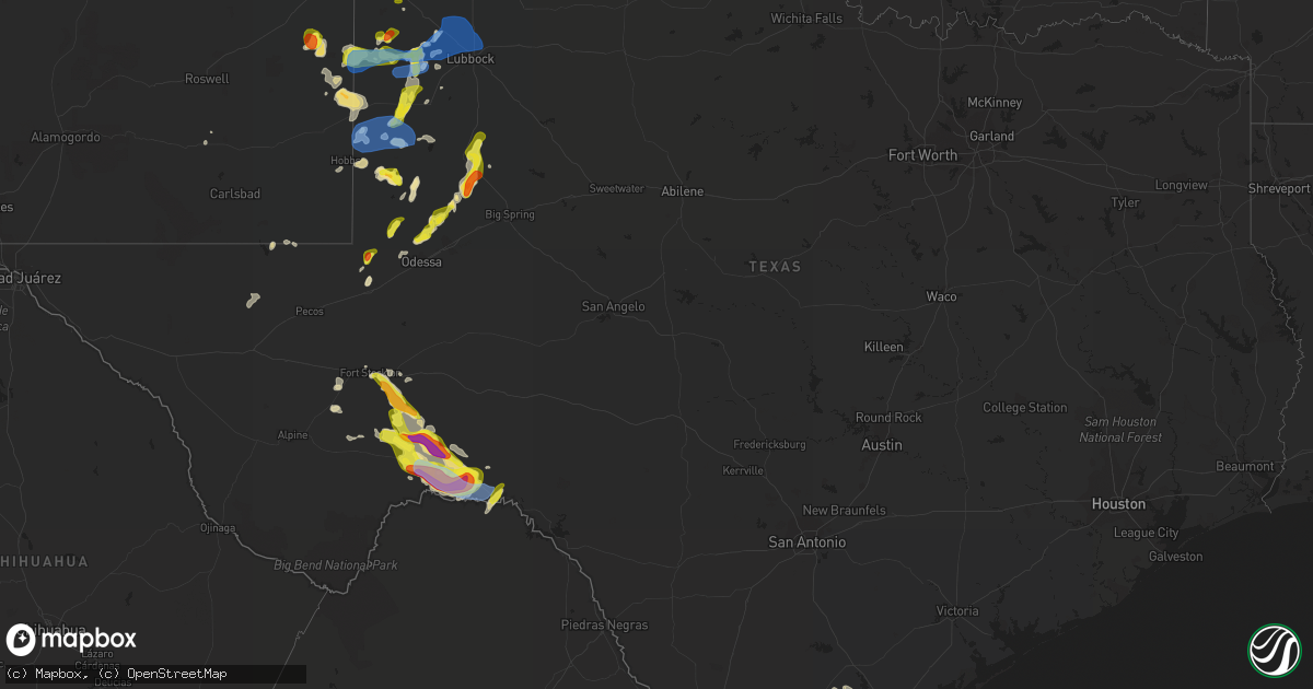
Hail Map in Texas on May 15, 2021
Get this storm
May 15 map
$229
one time, instant access
Download today. No call, no setup
Keep the $229
Bought the map and want the full workflow? Apply the entire $229 to a subscription within 7 days. None of it is wasted.
Every map, not just this one
This buys you this map. Subscription and you get every map we run, in the markets you choose from a few cities to whole states to nationwide. Plus real-time alerts the moment a storm fires.
Contact data
Name, contact info, occupancy, even credit band for addresses in the footprint. You go from where it hit to who to call.
Become the source they trust
Unlimited branding weather history reports on demand. You already have the documented answer ready for the property owner, and you are the one who showed up with it.
Property data and RoofTrace estimates
Pull up any address you have got, its value and the exact code rules for that jurisdiction, straight from One Click Code. Then RoofTrace estimates the squares, pitch, and roof value, priced the way you price.
Storm reports in Texas
Texas
| Date | Description |
|---|---|
| 05/15/20216:41 PM CDT | Social media video of hail up to quarters. |
| 05/15/20216:40 PM CDT | A local report indicates 1.00 inch wind near MORTON |
| 05/15/20216:33 PM CDT | Social media report of 2 inch hail at ranch rd 2400 and hwy 285. |
| 05/15/20214:51 PM CDT | Guadalupe pass asos |
| 05/15/20214:50 PM CDT | Spotter report of 1-1 1/4 hail driving through storm heading westbound into fort stockton. |
| 05/15/20211:35 PM CDT | Awos station kebg edinburg intl. |
| 05/15/20217:41 AM CDT | At 1240 PM CDT, a severe thunderstorm was located near Guillermo Flores Elementary School, or near Penitas, moving east at 40 mph. HAZARD...60 mph wind gusts and penny size hail. SOURCE...Radar indicated. IMPACT...Expect damage to roofs, siding, and trees. Locations impacted include... Mission, Pharr, Harlingen, Weslaco, San Juan, Alamo, Donna, Mercedes, La Feria and Progreso.This includes the following highways... US Highway 83 between mile markers 846 and 850. Interstate Highway 69 C between mile markers 1 and 3. US Highway 281 between mile markers 784 and 814. |
| 05/15/20214:59 AM CDT | At 958 PM CDT, a severe thunderstorm was located 4 miles east of Guymon, moving northeast at 30 mph. HAZARD...60 mph wind gusts and quarter size hail. SOURCE...Radar indicated. IMPACT...Minor damage to roofs, siding, and trees is possible. Hail damage to vehicles is expected. Locations impacted include... Guymon, Hooker, Goodwell, Optima, Hardesty and Adams. |
| 05/15/20214:49 AM CDT | At 948 PM CDT, a severe thunderstorm was located 4 miles northeast of Four Way, or 9 miles southeast of Dumas, moving northeast at 55 mph. HAZARD...60 mph wind gusts and quarter size hail. SOURCE...Radar indicated. IMPACT...Minor damage to roofs, siding, and trees is possible. Hail damage to vehicles is expected. Locations impacted include... Dumas, Sunray, Morse, Four Way and Pringle. |
| 05/15/20214:32 AM CDT | At 931 PM CDT, a severe thunderstorm was located over Bushland, or 12 miles west of Amarillo, moving northeast at 30 mph. HAZARD...60 mph wind gusts and quarter size hail. SOURCE...Radar indicated. IMPACT...Minor damage to roofs, siding, and trees is possible. Hail damage to vehicles is expected. Locations impacted include... Amarillo, Umbarger, Bushland and Valley De Oro. |
| 05/15/20214:31 AM CDT | At 931 PM CDT, severe thunderstorms were located along a line extending from 4 miles south of Cotton Center to near Downtown Lubbock to 8 miles north of New Moore, moving east at 55 mph. HAZARD...60 mph wind gusts and penny size hail. SOURCE...Radar indicated. IMPACT...Expect damage to roofs, siding, and trees. Locations impacted include... Lubbock, Slaton, Post, Floydada, Abernathy, Tahoka, Crosbyton, Spur, Matador, Dickens, Lake Alan Henry, White River Lake, Wolfforth, Shallowater, Idalou, Ralls, Petersburg, Lorenzo, Ransom Canyon and Cotton Center. |
| 05/15/20214:22 AM CDT | At 922 PM CDT, a severe thunderstorm was located over Cactus, or 13 miles north of Dumas, moving northeast at 20 mph. HAZARD...60 mph wind gusts and half dollar size hail. SOURCE...Trained weather spotters. IMPACT...Minor damage to roofs, siding, and trees is possible. Hail damage to vehicles is expected. Locations impacted include... Cactus and Sunray. |
| 05/15/20214:22 AM CDT | At 922 PM CDT, severe thunderstorms were located along a line extending from 10 miles southeast of Terrell County Gas Plant to near Pumpville to 20 miles southeast of Dryden, moving east at 20 mph. HAZARD...60 mph wind gusts and quarter size hail. SOURCE...Radar indicated. IMPACT...Hail damage to vehicles is expected. Expect wind damage to roofs, siding, and trees. Locations impacted include... Langtry, Shumla, Pumpville and Pandale. |
| 05/15/20214:11 AM CDT | At 911 PM CDT, severe thunderstorms were located along a line extending from near Terrell County Gas Plant to 9 miles west of Pumpville to 14 miles south of Dryden, moving east at 20 mph. HAZARD...Two inch hail and 70 mph wind gusts. SOURCE...Radar indicated. IMPACT...People and animals outdoors will be injured. Expect hail damage to roofs, siding, windows, and vehicles. Expect considerable tree damage. Wind damage is also likely to mobile homes, roofs, and outbuildings. These severe thunderstorms will remain over mainly rural areas of southeastern Terrell County. |
| 05/15/20214:06 AM CDT | At 906 PM CDT, a severe thunderstorm was located 6 miles southeast of O'donnell, or 14 miles northeast of Lamesa, moving northeast at 30 mph. HAZARD...Ping pong ball size hail and 60 mph wind gusts. SOURCE...Radar indicated. IMPACT...People and animals outdoors will be injured. Expect hail damage to roofs, siding, windows, and vehicles. Expect wind damage to roofs, siding, and trees. Locations impacted include... O'donnell and Grassland. |
| 05/15/20214:01 AM CDT | At 901 PM CDT, a severe thunderstorm was located over Langtry, moving northeast at 40 mph. HAZARD...Half dollar size hail. SOURCE...Radar indicated. IMPACT...Damage to vehicles is expected. Locations impacted include... Juno and Langtry. |
| 05/15/20213:59 AM CDT | At 858 PM CDT, a severe thunderstorm was located near O'donnell, or 14 miles northeast of Lamesa, moving north at 35 mph. HAZARD...Ping pong ball size hail and 60 mph wind gusts. SOURCE...Radar indicated. IMPACT...People and animals outdoors will be injured. Expect hail damage to roofs, siding, windows, and vehicles. Expect wind damage to roofs, siding, and trees. Locations impacted include... Hancock and Arvana. |
| 05/15/20213:27 AM CDT | At 827 PM CDT, a severe thunderstorm was located 8 miles northwest of Ackerly, moving north at 25 mph. HAZARD...60 mph wind gusts and half dollar size hail. SOURCE...Radar indicated. IMPACT...Hail damage to vehicles is expected. Expect wind damage to roofs, siding, and trees. Locations impacted include... Lamesa Municipal Airport, Los Ybanez, Sparenberg, Tenmile, Arvana, Hancock and Key. |
| 05/15/20213:24 AM CDT | At 823 PM CDT, severe thunderstorms were located along a line extending from 6 miles northeast of Pep to 9 miles west of Whitharral to 6 miles east of Levelland to 7 miles north of Brownfield to Seagraves Airport, moving east at 20 mph. HAZARD...70 mph wind gusts and half dollar size hail. SOURCE...Radar indicated. IMPACT...Hail damage to vehicles is expected. Expect considerable tree damage. Wind damage is also likely to mobile homes, roofs, and outbuildings. Locations impacted include... Lubbock, Levelland, Brownfield, Littlefield, Slaton, Denver City, Abernathy, Tahoka, Plains, Wolfforth, Shallowater, Idalou, Sundown, Anton, Ransom Canyon, Cotton Center, New Moore, Spade, Tokio and Lubbock South Plains Mall. |
| 05/15/20213:12 AM CDT | At 812 PM CDT, severe thunderstorms were located along a line extending from 17 miles southwest of Terrell County Gas Plant to near Dryden to 13 miles south of Sanderson, moving southeast at 25 mph. HAZARD...Tennis ball size hail and 70 mph wind gusts. SOURCE...Radar indicated. IMPACT...People and animals outdoors will be injured. Expect hail damage to roofs, siding, windows, and vehicles. Expect considerable tree damage. Wind damage is also likely to mobile homes, roofs, and outbuildings. Locations impacted include... Dryden, Sanderson and Terrell County Airport. |
| 05/15/20213:10 AM CDT | At 809 PM CDT, a severe thunderstorm was located near Alfred, or 9 miles north of Alice, moving southeast at 20 mph. HAZARD...60 mph wind gusts and half dollar size hail. SOURCE...Radar indicated. IMPACT...Hail damage to vehicles is expected. Expect wind damage to roofs, siding, and trees. Locations impacted include... Alice, Orange Grove, Tecalote, Alfred-South La Paloma, Alice Acres, Alfred, Agua Dulce and Lake Alice.This includes US Highway 281 between mile markers 662 and 676. |
| 05/15/20212:38 AM CDT | At 737 PM CDT, severe thunderstorms were located along a line extending from 4 miles southeast of Maple to near Denver City, moving east at 35 mph. HAZARD...Golf ball size hail and 70 mph wind gusts. SOURCE...Radar indicated. IMPACT...People and animals outdoors will be injured. Expect hail damage to roofs, siding, windows, and vehicles. Expect considerable tree damage. Wind damage is also likely to mobile homes, roofs, and outbuildings. Locations impacted include... Levelland, Brownfield, Denver City, Morton, Sundown, Anton, Tokio, Enochs, Locketville, Whitharral, Pep, Lehman, Meadow, Smyer, Whiteface, Ropesville, Wellman and Opdyke West. |
| 05/15/20212:33 AM CDT | At 732 PM CDT, a severe thunderstorm was located 13 miles northeast of Sanderson, moving east at 15 mph. HAZARD...Two inch hail and 70 mph wind gusts. SOURCE...Radar indicated. IMPACT...People and animals outdoors will be injured. Expect hail damage to roofs, siding, windows, and vehicles. Expect considerable tree damage. Wind damage is also likely to mobile homes, roofs, and outbuildings. Locations impacted include... Dryden. |
| 05/15/20212:28 AM CDT | At 728 PM CDT, a severe thunderstorm was located near Sanderson, moving south at 35 mph. HAZARD...70 mph wind gusts and ping pong ball size hail. SOURCE...Radar indicated. IMPACT...People and animals outdoors will be injured. Expect hail damage to roofs, siding, windows, and vehicles. Expect considerable tree damage. Wind damage is also likely to mobile homes, roofs, and outbuildings. Locations impacted include... Sanderson. |
| 05/15/20212:25 AM CDT | At 724 PM CDT, a severe thunderstorm was located over Midway, or 17 miles west of Mathis, moving east at 20 mph. HAZARD...60 mph wind gusts and half dollar size hail. SOURCE...Radar indicated. IMPACT...Hail damage to vehicles is expected. Expect wind damage to roofs, siding, and trees. This severe thunderstorm will be near... Westdale around 755 PM CDT. Orange Grove and Alfred-South La Paloma around 800 PM CDT. Sandia around 805 PM CDT.Other locations impacted by this severe thunderstorm include PernitasPoint and Lakeside.This includes US Highway 281 between mile markers 644 and 660. |
| 05/15/20212:24 AM CDT | At 723 PM CDT, a severe thunderstorm was located 15 miles west of Lenorah, or 16 miles north of Midland, moving northeast at 35 mph. HAZARD...Two inch hail and 60 mph wind gusts. SOURCE...Radar indicated. IMPACT...People and animals outdoors will be injured. Expect hail damage to roofs, siding, windows, and vehicles. Expect wind damage to roofs, siding, and trees. Locations impacted include... Lamesa, Ackerly, Lenorah, Los Ybanez, Tarzan, Sparenberg, Tenmile, Patricia, Vealmoor and Klondike. |
| 05/15/20212:11 AM CDT | At 711 PM CDT, a severe thunderstorm was located near Gaines County Airport, or 8 miles south of Seminole, moving northeast at 10 mph. HAZARD...Ping pong ball size hail and 60 mph wind gusts. SOURCE...Radar indicated. IMPACT...People and animals outdoors will be injured. Expect hail damage to roofs, siding, windows, and vehicles. Expect wind damage to roofs, siding, and trees. Locations impacted include... Seminole, Seagraves, Seagraves Airport, Gaines County Airport, Loop and Gaines County Park. |
| 05/15/20211:49 AM CDT | At 649 PM CDT, a severe thunderstorm was located 6 miles northwest of Seagraves, moving northeast at 25 mph. HAZARD...60 mph wind gusts and quarter size hail. SOURCE...Radar indicated. IMPACT...Hail damage to vehicles is expected. Expect wind damage to roofs, siding, and trees. Locations impacted include... Brownfield, Tokio and Wellman. |
| 05/15/20211:44 AM CDT | At 643 PM CDT, a severe thunderstorm was located 11 miles northwest of Midland International Air and Space Port, or 12 miles north of Odessa, moving northeast at 25 mph. HAZARD...60 mph wind gusts and quarter size hail. SOURCE...Radar indicated. IMPACT...Hail damage to vehicles is expected. Expect wind damage to roofs, siding, and trees. This severe thunderstorm will remain over mainly rural areas of northeastern Ector, southeastern Andrews, northwestern Midland and southwestern Martin Counties. |
| 05/15/20211:41 AM CDT | At 639 PM CDT, a severe thunderstorm was located 13 miles north of Sanderson, moving east at 20 mph. HAZARD...Tennis ball size hail and 60 mph wind gusts. SOURCE...Public reported 2 inch hail on 14 miles north of Sanderson. IMPACT...People and animals outdoors will be injured. Expect hail damage to roofs, siding, windows, and vehicles. Expect wind damage to roofs, siding, and trees. Locations impacted include... Sanderson and Terrell County Airport. |
| 05/15/20211:25 AM CDT | At 624 PM CDT, a severe thunderstorm was located over Morton, moving northeast at 10 mph. HAZARD...60 mph wind gusts and quarter size hail. SOURCE...Radar indicated. IMPACT...Hail damage to vehicles is expected. Expect wind damage to roofs, siding, and trees. Locations impacted include... Morton, Enochs and Pep. |
| 05/15/20211:10 AM CDT | At 609 PM CDT, a severe thunderstorm was located 22 miles northwest of Sanderson, moving south at 15 mph. HAZARD...Golf ball size hail and 60 mph wind gusts. SOURCE...Radar indicated. IMPACT...People and animals outdoors will be injured. Expect hail damage to roofs, siding, windows, and vehicles. Expect wind damage to roofs, siding, and trees. This severe thunderstorm will remain over mainly rural areas of south central Pecos and northwestern Terrell Counties. |
| 05/15/20211:06 AM CDT | At 605 PM CDT, a severe thunderstorm was located 13 miles east of Kermit, moving northeast at 20 mph. HAZARD...Ping pong ball size hail and 60 mph wind gusts. SOURCE...Radar indicated. IMPACT...People and animals outdoors will be injured. Expect hail damage to roofs, siding, windows, and vehicles. Expect wind damage to roofs, siding, and trees. Locations impacted include... Goldsmith and Notrees. |
| 05/15/202112:29 AM CDT | At 528 PM MDT, a severe thunderstorm was located 12 miles west of Hayden, or 18 miles west of Amistad, moving northeast at 15 mph. HAZARD...60 mph wind gusts and quarter size hail. SOURCE...Radar indicated. IMPACT...Hail damage to vehicles is expected. Expect wind damage to roofs, siding, and trees. Locations impacted include... Amistad, Hayden, Sedan and Rosebud. |
| 05/15/202112:24 AM CDT | At 523 PM CDT, a severe thunderstorm was located 26 miles southeast of Fort Stockton, moving southeast at 25 mph. HAZARD...60 mph wind gusts and half dollar size hail. SOURCE...Radar indicated. IMPACT...Hail damage to vehicles is expected. Expect wind damage to roofs, siding, and trees. This severe thunderstorm will remain over mainly rural areas of south central Pecos and northwestern Terrell Counties. |
| 05/15/202112:22 AM CDT | At 521 PM CDT, a severe thunderstorm was located 4 miles east of Morton, and is nearly stationary. HAZARD...60 mph wind gusts and quarter size hail. SOURCE...Radar indicated. IMPACT...Hail damage to vehicles is expected. Expect wind damage to roofs, siding, and trees. Locations impacted include... Morton and Pep. |
| 05/15/202112:18 AM CDT | At 518 PM CDT, a severe thunderstorm was located 4 miles south of Sudan, or 11 miles northwest of Littlefield, moving northeast at 15 mph. HAZARD...60 mph wind gusts and quarter size hail. SOURCE...Radar indicated. IMPACT...Hail damage to vehicles is expected. Expect wind damage to roofs, siding, and trees. Locations impacted include... Littlefield, Earth, Sudan, Amherst, Fieldton and Springlake. |
| 05/15/202112:13 AM CDT | At 513 PM MDT, a severe thunderstorm was located near Portales, and is nearly stationary. HAZARD...60 mph wind gusts and quarter size hail. SOURCE...Radar indicated. IMPACT...Hail damage to vehicles is expected. Expect wind damage to roofs, siding, and trees. Locations impacted include... Portales, Dora, Floyd, Arch, Oasis State Park and Rogers. |
| 05/14/202111:44 PM CDT | At 444 PM CDT, a severe thunderstorm was located 16 miles southeast of Fort Stockton, moving east at 25 mph. HAZARD...60 mph wind gusts and quarter size hail. SOURCE...Radar indicated. IMPACT...Hail damage to vehicles is expected. Expect wind damage to roofs, siding, and trees. Locations impacted include... Bakersfield.This includes Interstate 10 between mile markers 266 and 303. |
| 05/14/202111:30 PM CDT | At 429 PM CDT, a severe thunderstorm was located 4 miles east of Morton, moving northeast at 10 mph. HAZARD...60 mph wind gusts and quarter size hail. SOURCE...Radar indicated. IMPACT...Hail damage to vehicles is expected. Expect wind damage to roofs, siding, and trees. Locations impacted include... Morton and Pep. |
| 05/14/202110:55 PM CDT | At 354 PM MDT, a severe thunderstorm was located near Milnesand, or 30 miles north of Tatum, moving southeast at 5 mph. HAZARD...Ping pong ball size hail and 60 mph wind gusts. SOURCE...Radar indicated. IMPACT...People and animals outdoors will be injured. Expect hail damage to roofs, siding, windows, and vehicles. Expect wind damage to roofs, siding, and trees. Locations impacted include... Milnesand, Lingo and Pep. |
| 05/14/202110:34 PM CDT | At 334 PM MDT, a severe thunderstorm was located 7 miles south of Grady, or 21 miles north of Clovis, moving east at 15 mph. HAZARD...60 mph wind gusts and half dollar size hail. SOURCE...Radar indicated. IMPACT...Hail damage to vehicles is expected. Expect wind damage to roofs, siding, and trees. Locations impacted include... Grady, Broadview and Bellview. |
| 05/14/202110:32 PM CDT | At 332 PM MDT, a severe thunderstorm was located over Portales, moving east at 10 mph. HAZARD...60 mph wind gusts and half dollar size hail. SOURCE...Radar indicated. IMPACT...Hail damage to vehicles is expected. Expect wind damage to roofs, siding, and trees. Locations impacted include... Portales, Floyd, Arch and Oasis State Park. This includes Highway 60 between Mile Markers 392 and 393. |
| 05/14/202110:15 PM CDT | At 315 PM MDT, a severe thunderstorm was located 7 miles northwest of Milnesand, or 31 miles south of Portales, moving east at 10 mph. HAZARD...60 mph wind gusts and half dollar size hail. SOURCE...Radar indicated. IMPACT...Hail damage to vehicles is expected. Expect wind damage to roofs, siding, and trees. Locations impacted include... Dora, Milnesand and Pep. |
| 05/14/20219:22 PM CDT | Quarter to just below ping pong ball size hail was falling at time of report. |
| 05/14/20219:15 PM CDT | Truck driver reported seeing 2 inch hail at us hwy 90 and cedar rd. |
| 05/14/20218:55 PM CDT | West texas mesonet report |
| 05/14/20218:43 PM CDT | A local report indicates 61 MPH wind near 1 SW SEAGRAVES |
| 05/14/20218:30 PM CDT | Time estimated from radar based off late public report. |
| 05/14/20218:26 PM CDT | At 126 PM CDT, severe thunderstorms were located along a line extending from Monte Alto to La Villa to Olivarez to A.p. Solis Middle School, moving east at 45 mph. HAZARD...60 mph wind gusts and penny size hail. SOURCE...Radar indicated. IMPACT...Expect damage to roofs, siding, and trees. Locations impacted include... Harlingen, Weslaco, Donna, Mercedes, Raymondville, La Feria, Progreso, Edcouch, Santa Rosa and Lyford.This includes the following highways... Interstate Highway 69 E between mile markers 21 and 51. US Highway 77 near mile marker 762. US Highway 281 between mile markers 792 and 820. |
| 05/14/20218:25 PM CDT | Reported from south plains college |
| 05/14/20218:21 PM CDT | A local report indicates 60 MPH wind near 5 W DRYDEN |
| 05/14/20218:05 PM CDT | West texas mesonet report |
| 05/14/20218:02 PM CDT | At 102 PM CDT, a severe thunderstorm was located over Edinburg Regional Medical Center, or over Edinburg, moving east at 45 mph. HAZARD...60 mph wind gusts and penny size hail. SOURCE...Radar indicated. IMPACT...Expect damage to roofs, siding, and trees. Locations impacted include... Edinburg, Harlingen, Raymondville, Elsa, Edcouch, Santa Rosa, Lyford, Palmhurst, La Villa and North McAllen.This includes the following highways... Interstate Highway 69 E between mile markers 42 and 45. Interstate Highway 69 C between mile markers 3 and 12. |
| 05/14/20218:02 PM CDT | Wind driven golf ball sized hail broke south facing windows on home. |
| 05/14/20217:42 PM CDT | Trained spotter reported slightly larger than quarter sized hail. |
All States Impacted by Hail Map on May 15, 2021
Cities Impacted by Hail Map on May 15, 2021
- Scott City, KS
- Amistad, NM
- Tatum, NM
- Morton, TX
- Tribune, KS
- Clayton, NM
- Grant, NE
- Champion, NE
- Baldwin, WI
- Spring Valley, WI
- Dryden, TX
- Sanderson, TX
- Fort Stockton, TX
- Campo, CO
- Wakeeney, KS
- Denver City, TX
- Seminole, TX
- Beeler, KS
- Kermit, TX
- Portales, NM
- Crossroads, NM
- Comstock, TX
- Levelland, TX
- Winona, KS
- Leoti, KS
- New Richmond, WI
- Healy, KS
- Ackerly, TX
- Lamesa, TX
- Artesia, NM
- Randalia, IA
- Westgate, IA
- Maynard, IA
- Indianola, NE
- McCook, NE
- Oberlin, KS
- Danbury, NE
- Mosquero, NM
- Paxton, NE
- Keystone, NE
- Ogallala, NE
- Gypsum, KS
- Larned, KS
- Elmwood, WI
- Ellsworth, WI
- Madrid, NE
- Elsie, NE
- Kit Carson, CO
- Augusta, KS
- El Dorado, KS
- Rosalia, KS
- Leon, KS
- Palco, KS
- Granada, CO
- Wabasha, MN
- Pepin, WI
- Reads Landing, MN
- Kellogg, MN
- Stockholm, WI
- Lake City, MN
- Tarzan, TX
- Stanton, TX
- Eureka, NV
- Amery, WI
- Dresser, WI
- Hays, KS
- Andrews, TX
- Deer Park, WI
- Bay City, WI
- Maiden Rock, WI
- Seagraves, TX
- Springfield, CO
- Sedan, NM
- Canyon, TX
- Colo, IA
- Goldsmith, TX
- Saint Croix Falls, WI
- Stafford, KS
- Hammond, WI
- Woodville, WI
- Altura, MN
- Plum City, WI
- Elgin, MN
- Millville, MN
- Beldenville, WI
- Plainview, MN
- Sylvan Grove, KS
- Dorrance, KS
- Lucas, KS
- Tucumcari, NM
- Gardendale, TX
- Midland, TX
- Plains, TX
- Milnesand, NM
- Lenorah, TX
- Hershey, NE
- Castle Rock, CO
- Franktown, CO
- Sheridan Lake, CO
- Haysville, KS
- Halstead, KS
- Sedgwick, KS
- Brownfield, TX
- Tokio, TX
- St John, KS
- Copeland, KS
- Walsh, CO
- Valley Center, KS
- Maize, KS
- Wichita, KS
- Colwich, KS
- Bentley, KS
- Dalhart, TX
- Lewellen, NE
- Shafer, MN
- Taylors Falls, MN
- Forgan, OK
- Montezuma, KS
- Elida, NM
- Pep, NM
- Marathon, TX
- Plainville, KS
- Boise City, OK
- Pecos, TX
- Salina, KS
- Anton, TX
- Sandia, TX
- George West, TX
- Mentone, TX
- Orange Grove, TX
- Grinnell, KS
- Hoxie, KS
- Amarillo, TX
- Texline, TX
- Floyd, NM
- Fall River, KS
- Fredonia, KS
- Hobbs, NM
- Luray, KS
- Bunker Hill, KS
- Towanda, KS
- Brookville, KS
- Tescott, KS
- Dumas, TX
- Schoenchen, KS
- Liebenthal, KS
- La Crosse, KS
- Venango, NE
- Ely, NV
- Monahans, TX
- Oakley, KS
- Dighton, KS
- Whiteface, TX
- Waldo, KS
- Amherst, TX
- Meadow, TX
- Lakeport, CA
- Hawkeye, IA
- Waucoma, IA
- Raton, NM
- Lubbock, TX
- Wallace, NE
- Toronto, KS
- Emporia, KS
- Strong City, KS
- Bethune, CO
- State Center, IA
- Burlington, CO
- Melvern, KS
- La Junta, CO
- Las Animas, CO
- Ingalls, KS
- North Platte, NE
- Lovington, NM
- Bison, KS
- Des Moines, NM
- Lemoyne, NE
- Guymon, OK
- Stockton, KS
- Bogue, KS
- Damar, KS
- Morland, KS
- Hudson, KS
- Fayette, IA
- Beulah, CO
- Kress, TX
- Eads, CO
- Pawnee Rock, KS
- Kenton, OK
- Maxwell, NE
- Admire, KS
- Holly, CO
- Pueblo, CO
- Fairbank, IA
- Oelwein, IA
- Readlyn, IA
- Sumner, IA
- Felt, OK
- Lake Arthur, NM
- Grainfield, KS
- Tripoli, IA
- Spring Creek, NV
- Two Buttes, CO
- Ensign, KS
- Larkspur, CO
- Lincoln, KS
- Rocky Ford, CO
- Solano, NM
- Rush Center, KS
- Baxter, IA
- Vilas, CO
- Danville, KS
- Alice, TX
- Lakin, KS
- Kingsville, TX
- Hooker, OK
- Texico, NM
- Rawlins, WY
- Aurora, CO
- Gail, TX
- Wildorado, TX
- Garden City, KS
- Ness City, KS
- River Falls, WI
- Oconto, NE
- Mission, TX
- Edinburg, TX
- La Joya, TX
- Elsa, TX
- Mcallen, TX
- Penitas, TX
- Pharr, TX
- Edcouch, TX
- New Deal, TX
- Shallowater, TX
- Idalou, TX
- Ropesville, TX
- Smyer, TX
- Abernathy, TX
- Sundown, TX
- Loop, TX
- Pep, TX
- Sudan, TX
- Stratford, TX
- Saint Charles, MN
- Chatfield, MN
- Dover, MN
- Fountain, MN
- Logan, NM
- San Jon, NM
- Avondale, CO


