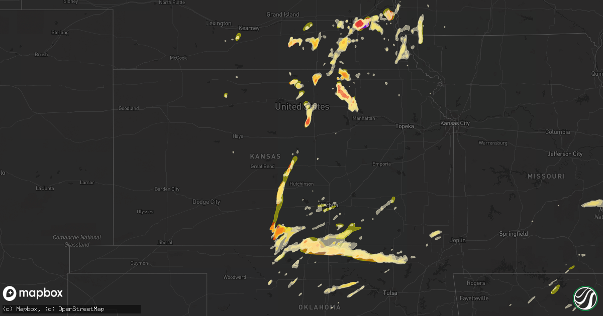
Hail Map in Kansas on May 9, 2016
Get this storm
May 9 map
$229
one time, instant access
Download today. No call, no setup
Keep the $229
Bought the map and want the full workflow? Apply the entire $229 to a subscription within 7 days. None of it is wasted.
Every map, not just this one
This buys you this map. Subscription and you get every map we run, in the markets you choose from a few cities to whole states to nationwide. Plus real-time alerts the moment a storm fires.
Contact data
Name, contact info, occupancy, even credit band for addresses in the footprint. You go from where it hit to who to call.
Become the source they trust
Unlimited branding weather history reports on demand. You already have the documented answer ready for the property owner, and you are the one who showed up with it.
Property data and RoofTrace estimates
Pull up any address you have got, its value and the exact code rules for that jurisdiction, straight from One Click Code. Then RoofTrace estimates the squares, pitch, and roof value, priced the way you price.
Storm reports in Kansas
Kansas
| Date | Description |
|---|---|
| 05/09/20166:54 PM CDT | Relayed by social media. Radar estimated time. |
| 05/09/20166:52 PM CDT | Between 50-60 mph |
| 05/09/20166:49 PM CDT | A local report indicates 1.75 inch wind near CALDWELL |
| 05/09/20166:47 PM CDT | A local report indicates 1.50 inch wind near 2 E BELLEVILLE |
| 05/09/20166:45 PM CDT | Via social media |
| 05/09/20166:41 PM CDT | A local report indicates 2.75 inch wind near 2 NW LINN |
| 05/09/20166:40 PM CDT | Small brief tornado seen by storm chaser over open field. |
| 05/09/20166:34 PM CDT | A local report indicates 1.00 inch wind near 7 N GREEN |
| 05/09/20166:33 PM CDT | Tree damage has been reported across the city. An 18 inch diameter tree snapped. |
| 05/09/20166:33 PM CDT | Range from golfball to tennis ball size hail |
| 05/09/20166:27 PM CDT | Report via ham radio. |
| 05/09/20166:20 PM CDT | A local report indicates 65 MPH wind near 2 E TOWANDA |
| 05/09/20166:20 PM CDT | A local report indicates 65 MPH wind near 1 W EL DORADO |
| 05/09/20166:15 PM CDT | Nickel to quarter |
| 05/09/20166:12 PM CDT | A local report indicates 60 MPH wind near 1 N AUGUSTA |
| 05/09/20166:11 PM CDT | Via twitter. |
| 05/09/20166:07 PM CDT | Also penny size hail. |
| 05/09/20165:58 PM CDT | Some pea to dime hail also. At harry and rock road. Via twitter. |
| 05/09/20165:53 PM CDT | A local report indicates 1.00 inch wind near 5 NE DELPHOS |
| 05/09/20165:50 PM CDT | A local report indicates 1.25 inch wind near 3 NNE LEONARDVILLE |
| 05/09/20165:50 PM CDT | A local report indicates 1.00 inch wind near DELPHOS |
| 05/09/20165:48 PM CDT | Central and ridge |
| 05/09/20165:48 PM CDT | Report and picture via twitter |
| 05/09/20165:47 PM CDT | Pea sized hail also reported. |
| 05/09/20165:47 PM CDT | At macarthur and west. Via kfdi radio. |
| 05/09/20165:44 PM CDT | 6-7 inch tree knocked down at lewis and laura. Delayed report. Via twitter. |
| 05/09/20165:40 PM CDT | A local report indicates 2.00 inch wind near 3 W RANDOLPH |
| 05/09/20165:30 PM CDT | Baseball size hail decreased to dollar coin size by 533 pm. |
| 05/09/20165:22 PM CDT | Report via twitter |
| 05/09/20165:00 PM CDT | Mixed with some dime and nickel hail on highway 4. |
| 05/09/20164:55 PM CDT | A local report indicates 60 MPH wind near 2 E GENESEO |
| 05/09/20164:55 PM CDT | One inch hail also reported at this location. |
| 05/09/20164:33 PM CDT | A local report indicates 1.75 inch wind near LYONS |
| 05/09/20164:26 PM CDT | Trees blown down across town. Some 12 inches in diamter. Delayed report. |
| 05/09/20164:26 PM CDT | Also dime size hail and some tree damage. |
| 05/09/20164:25 PM CDT | A local report indicates 1.75 inch wind near 5 N STERLING |
| 05/09/20163:59 PM CDT | A local report indicates 1.00 inch wind near KIOWA |
| 05/09/20163:58 PM CDT | A local report indicates 1.75 inch wind near 3 E SHARON |
| 05/09/20163:51 PM CDT | Dime to quarter size hail. |
| 05/09/20163:49 PM CDT | A local report indicates 1.00 inch wind near 5 NW ATTICA |
| 05/09/20163:45 PM CDT | A local report indicates 1.75 inch wind near SYLVIA |
| 05/09/20163:45 PM CDT | A local report indicates 1.00 inch wind near 3 NE SHARON |
| 05/09/20163:37 PM CDT | Quarter size hail with 40 to 50 mph |
| 05/09/20163:30 PM CDT | A local report indicates 2.50 inch wind near 3 N SHARON |
| 05/09/20163:20 PM CDT | 2 inch hail estimated by public |
| 05/09/20163:20 PM CDT | A local report indicates 1.75 inch wind near 1 WNW SHARON |
| 05/09/20163:18 PM CDT | A local report indicates 2.50 inch wind near 1 WNW MEDICINE LODGE |
| 05/09/20163:10 PM CDT | A local report indicates 1.00 inch wind near CUNNINGHAM |
| 05/09/20162:55 PM CDT | Wasn't home at the time of event but quarters still remained when arriving home. Most likely larger hail. |
| 05/09/20162:30 PM CDT | A local report indicates 1.50 inch wind near 1 W MEDICINE LODGE |
| 05/09/20162:18 PM CDT | A local report indicates 1.50 inch wind near 1 W MEDICINE LODGE |
| 05/08/201610:33 PM CDT | Quarter size hail 7 miles west of columbus |
| 05/08/20169:12 PM CDT | Ground 70 percent covered. Time adjusted based on radar. |
| 05/08/20169:10 PM CDT | Ground 70 percent covered |
| 05/08/20168:26 PM CDT | Report relayed via nwschat |
| 05/08/20168:04 PM CDT | 1 mile north of the kansas/oklahoma line along highway 77. |
| 05/08/20167:20 PM CDT | At winfield city lake. |
| 05/08/20167:06 PM CDT | A local report indicates 1.00 inch wind near 2 SW WINFIELD |
| 05/08/20167:00 PM CDT | Via photo on social media. Radar estimated time. |
All States Impacted by Hail Map on May 9, 2016
Cities Impacted by Hail Map on May 9, 2016
- Covington, OK
- Stamps, AR
- Leonardville, KS
- Randolph, KS
- Clearwater, KS
- Goddard, KS
- Wichita, KS
- Viola, KS
- Munden, KS
- Belleville, KS
- Scandia, KS
- Medford, OK
- Bokchito, OK
- New Boston, TX
- Texarkana, TX
- Simms, TX
- De Kalb, TX
- Maud, TX
- Hooks, TX
- Mahaska, KS
- Flippin, AR
- Columbus, KS
- Weeping Water, NE
- Murray, NE
- Nehawka, NE
- Plattsmouth, NE
- Louisville, NE
- Meno, OK
- Fairfield, NE
- Edgar, NE
- Clay Center, NE
- Glenvil, NE
- Hector, AR
- Milford, NE
- Kirkman, IA
- Harlan, IA
- Minneapolis, KS
- Glasco, KS
- Delphos, KS
- Tescott, KS
- Waldron, KS
- Kiowa, KS
- Hazelton, KS
- Burlington, OK
- Bassett, NE
- Cherokee, OK
- Taylor, NE
- Westboro, MO
- Tarkio, MO
- Wapanucka, OK
- Coalgate, OK
- Stonewall, OK
- Centrahoma, OK
- Atoka, OK
- Tupelo, OK
- Mankato, KS
- Garland City, AR
- Buckner, AR
- Lewisville, AR
- Davis, OK
- Wynnewood, OK
- Falls City, NE
- Durant, OK
- Bennington, OK
- Caddo, OK
- Caney, OK
- Pawhuska, OK
- Bartlesville, OK
- Boswell, OK
- Soper, OK
- Hugo, OK
- Brownville, NE
- Nemaha, NE
- Auburn, NE
- Medicine Lodge, KS
- Pawnee, OK
- Wayne, NE
- Wakefield, NE
- Madison, NE
- Norfolk, NE
- Tryon, NE
- Shelby, IA
- Avoca, IA
- Turon, KS
- Paris, TX
- Harvard, NE
- Texarkana, AR
- Barnes, KS
- Palmer, KS
- Linn, KS
- Greenleaf, KS
- Morrowville, KS
- Green, KS
- Washington, KS
- South Haven, KS
- Farragut, IA
- Riverton, IA
- Hamburg, IA
- Roff, OK
- Stapleton, NE
- Mead, OK
- Correctionville, IA
- Oneill, NE
- Pilger, NE
- Wisner, NE
- Glenwood, IA
- Martell, NE
- Lincoln, NE
- Denton, NE
- Roca, NE
- Walton, NE
- Mount Pleasant, AR
- Fairfax, SD
- Spencer, NE
- Bristow, NE
- Wellington, KS
- Jewell, KS
- Nash, OK
- Jet, OK
- Wetmore, KS
- Holton, KS
- Edgar Springs, MO
- Salem, MO
- Rolla, MO
- Lenox, MO
- Cunningham, KS
- Plevna, KS
- Sylvia, KS
- Newport, NE
- Stuart, NE
- Blossom, TX
- Morrison, OK
- Stillwater, OK
- Perry, OK
- Glencoe, OK
- Magazine, AR
- Booneville, AR
- Holdrege, NE
- Pacific Junction, IA
- Pleasant Dale, NE
- Courtland, KS
- Formoso, KS
- Jamestown, KS
- Beloit, KS
- Fredonia, KS
- Elmore City, OK
- Thermopolis, WY
- Petty, TX
- Roxton, TX
- Sumner, TX
- Brookston, TX
- Attica, KS
- Sharon, KS
- Milburn, OK
- Guthrie Center, IA
- Ivan, AR
- Udall, KS
- Winfield, KS
- Oxford, KS
- Honey Grove, TX
- Crete, NE
- Wilber, NE
- De Witt, NE
- Swanton, NE
- Plymouth, NE
- Western, NE
- Clarksville, TX
- Sioux City, IA
- South Sioux City, NE
- North Sioux City, SD
- Avoca, NE
- Blackwell, OK
- Newkirk, OK
- Braman, OK
- Paris, AR
- Harper, KS
- Amorita, OK
- Anthony, KS
- Strang, NE
- Shickley, NE
- Geneva, NE
- Newcastle, NE
- Maramec, OK
- Yale, OK
- Ripley, OK
- Salt Lake City, UT
- Julian, NE
- Nebraska City, NE
- Brock, NE
- Peru, NE
- Percival, IA
- Dorchester, NE
- Little River, KS
- Lyons, KS
- Atkinson, NE
- Kimball, SD
- Platte, SD
- Niobrara, NE
- Abilene, KS
- Sulphur, OK
- Stratford, OK
- Newalla, OK
- Norman, OK
- Annona, TX
- Mena, AR
- Clay Center, KS
- Seward, NE
- Bruning, NE
- Lavaca, AR
- Carthage, AR
- Rison, AR
- Grapevine, AR
- Madill, OK
- Fairbury, NE
- Daykin, NE
- West Valley City, UT
- Carleton, NE
- Pattonville, TX
- Detroit, TX
- Arthur City, TX
- Shidler, OK
- Boss, MO
- Stockton, KS
- Bogue, KS
- Unadilla, NE
- Heavener, OK
- Sergeant Bluff, IA
- Newman Grove, NE
- Peace Valley, MO
- Pomona, MO
- West Plains, MO
- Fairmont, NE
- Alden, KS
- Sterling, KS
- Grenola, KS
- Moline, KS
- Howard, KS
- Wickes, AR
- Umpire, AR
- Kaw City, OK
- Mountain View, AR
- Melbourne, AR
- Verdigre, NE
- Fairview, OK
- Deweese, NE
- Ellsworth, KS
- Firth, NE
- Fall River, KS
- Severy, KS
- Avery, TX
- Bluff City, KS
- Dewey, OK
- Wann, OK
- Delaware, OK
- Mcloud, OK
- Tecumseh, OK
- Elmwood, NE
- Palmyra, NE
- Syracuse, NE
- Eagle, NE
- Summerfield, KS
- Beattie, KS
- Essex, IA
- Shenandoah, IA
- Coin, IA
- Northboro, IA
- Haworth, OK
- Ashdown, AR
- Nash, TX
- Foreman, AR
- Stanton, NE
- Stringtown, OK
- Bogata, TX
- Windom, TX
- Idabel, OK
- Fouke, AR
- Powderly, TX
- Waldo, AR
- Deport, TX
- Bagwell, TX
- Smithland, IA
- Hornick, IA
- Albion, NE
- Petersburg, NE
- Johnson, NE
- Elk Creek, NE
- Oswego, KS
- Caulfield, MO
- Guthrie, OK
- Coyle, OK
- Lamont, OK
- West Point, NE
- Sparkman, AR
- Waterville, KS
- Burbank, OK
- Arkansas City, KS
- Ponca City, OK
- Manchester, OK
- Nardin, OK
- Caldwell, KS
- Geneseo, KS
- Hanover, KS
- Hollenberg, KS
- Alexandria, NE
- Coon Rapids, IA
- Murdock, NE
- Calera, OK
- Kingston, OK
- Riley, KS
- Manhattan, KS
- Maskell, NE
- Hartington, NE
- Hoskins, NE
- Winside, NE
- Foster, OK
- Pauls Valley, OK
- Pretty Prairie, KS
- Dardanelle, AR
- Delaware, AR
- Shubert, NE
- Stella, NE
- Humboldt, NE
- Seneca, KS
- Meadow Grove, NE
- Danville, KS
- Olsburg, KS
- Clifton, KS
- Waterbury, NE
- Allen, NE
- Emerson, NE
- Jerusalem, AR
- Pelsor, AR
- Dover, AR
- Alvo, NE
- Akron, IA
- Mountain Home, AR
- Oto, IA
- Tecumseh, NE
- Endicott, NE
- Plainview, AR
- Carroll, NE
- Burrton, KS
- Cheney, KS
- Clatonia, NE
- Cortland, NE
- Perkins, OK
- Mayfield, KS
- Milan, KS
- Argonia, KS
- Wakita, OK
- Ochelata, OK
- Geuda Springs, KS
- Nowata, OK
- Aurora, KS
- Concordia, KS
- Lynch, NE
- Lake Andes, SD
- Chetopa, KS
- Irwin, IA
- Defiance, IA
- Watson, OK
- Grannis, AR
- Murfreesboro, AR
- Dierks, AR
- Nashville, AR
- Lockesburg, AR
- Delight, AR
- De Queen, AR
- Orlando, OK
- Toronto, KS
- Altus, AR
- Poteau, OK
- Hackett, AR
- Cameron, OK
- Graham, TX
- Douglass, KS
- Rose Hill, KS
- Hubbard, NE
- Charleston, AR
- Mulvane, KS
- Dawson, NE
- Ames, OK
- Lahoma, OK
- Ringwood, OK
- Cook, NE
- Cleveland, OK
- Moville, IA
- Lawton, IA
- Bronson, IA
- Red Oak, IA
- North Platte, NE
- Hallam, NE
- Jansen, NE
- Galva, KS
- Mcpherson, KS
- Marietta, OK
- Colwich, KS
- Thackerville, OK
- Jennings, OK
- Anthon, IA
- Okolona, AR
- Milligan, NE
- Exeter, NE
- Sidney, IA
- Hennessey, OK
- Cambridge, KS
- Latham, KS
- Bennet, NE
- Narka, KS
- Haddam, KS
- Milton, KS
- Burden, KS
- Oklahoma City, OK
- Bixby, MO
- Mullen, NE
- Tishomingo, OK
- Broken Bow, OK
- Valley Center, KS
- Maize, KS
- Winnebago, NE
- Thurston, NE
- Burbank, SD
- Dacoma, OK
- Redfield, SD
- Hot Springs Village, AR
- Lonsdale, AR
- Choctaw, OK
- Barnsdall, OK
- Watson, MO
- Rodney, IA
- Onawa, IA
- Whiting, IA
- Climbing Hill, IA
- Benton, AR
- Paron, AR
- Wood Lake, NE
- Saint Joe, AR
- Western Grove, AR
- Everton, AR
- Pindall, AR
- Subiaco, AR
- Rock Port, MO
- Enid, OK
- Funk, NE
- Gassville, AR
- Cotter, AR
- Ong, NE
- Bertrand, NE
- Beresford, SD
- Norwich, KS
- Wanette, OK
- Fort Smith, AR
- Atchison, KS
- Sawyer, OK
- Spencerville, OK
- Fort Towson, OK
- Shady Point, OK
- Cecil, AR
- Kenefic, OK
- Henderson, NE
- Copan, OK
- Friend, NE
- Beaver Crossing, NE
- Magna, UT
- Gainesville, TX
- Helena, OK
- Greenwood, AR
- Pickrell, NE
- Le Mars, IA
- Tabor, SD
- Ponca, AR
- Parthenon, AR
- Grafton, NE
- Sutton, NE
- Whitesboro, TX
- Treynor, IA
- Edmond, OK
- Marysville, KS
- Bremen, KS
- Mansfield, AR
- Dexter, KS
- Tulare, SD
- Loomis, NE
- Verdon, NE
- Bedford, IA
- New Market, IA
- Westfield, IA
- Alva, OK
- Arkadelphia, AR
- Blanchard, IA
- Little Rock, AR
- Red Oak, OK
- Rattan, OK
- Snow, OK
- Finley, OK
- Elk Point, SD
- Jefferson, SD
- Hebron, NE
- Hubbell, NE
- Gillham, AR
- Newhope, AR
- Hinton, IA
- Dakota City, NE
- Marshfield, MO
- Niangua, MO
- Richland, MO
- Laquey, MO
- Fordyce, AR
- Clarksville, AR
- Merrill, IA
- Maple City, KS
- Aline, OK
- McCracken, KS
- Wynot, NE
- Lexington, OK
- Bartlett, KS
- Bakersfield, MO
- Ozark, AR
- Hartman, AR
- Phillipsburg, KS
- Manley, NE
- Maxwell, NE
- Whitman, NE
- Cleo Springs, OK
- Carrier, OK
- Drummond, OK
- Deer Creek, OK
- Fittstown, OK
- Ada, OK
- Fitzhugh, OK
- Noble, OK
- Shawnee, OK
- Pittsburg, OK
- Hickman, NE
- Union, NE
- Mcconnell Afb, KS
- Belle Plaine, KS
- Nashville, KS
- Isabel, KS
- Norfork, AR
- Moody, MO
- York, NE
- Logan, KS
- Webber, KS


