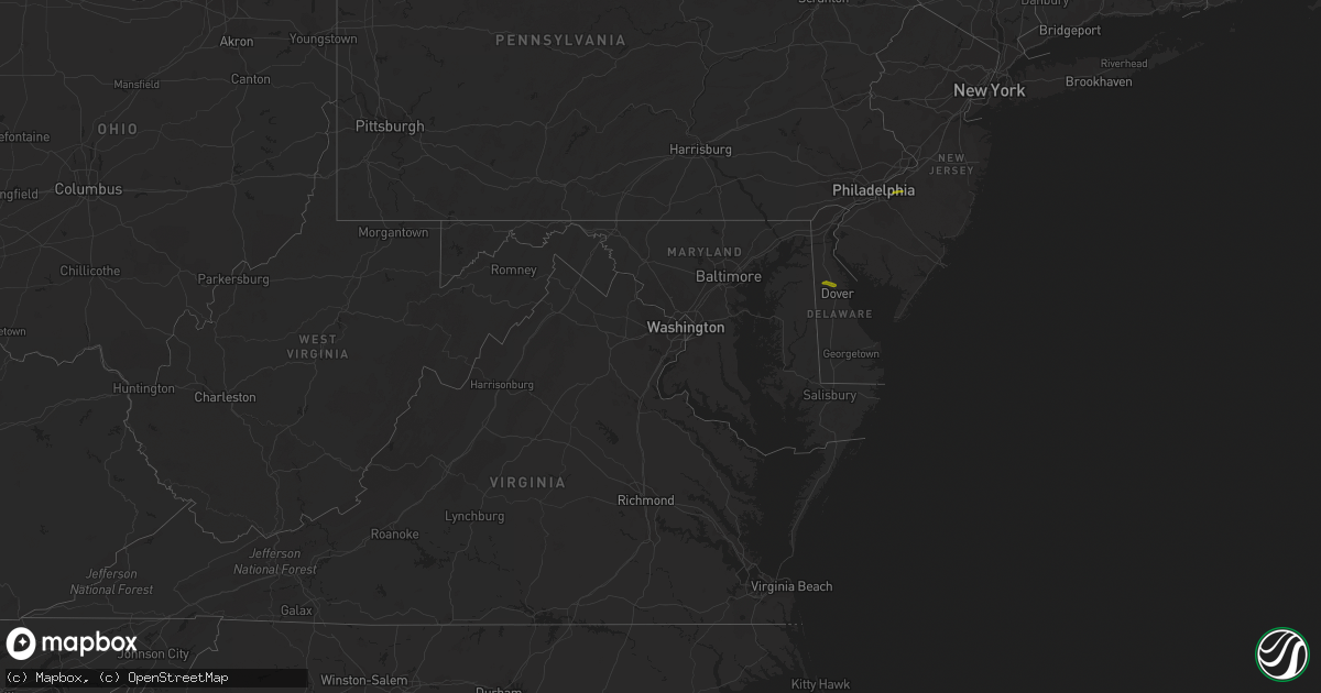
Hail Map in Delaware on April 16, 2022
Get this storm
April 16 map
$229
one time, instant access
Download today. No call, no setup
Keep the $229
Bought the map and want the full workflow? Apply the entire $229 to a subscription within 7 days. None of it is wasted.
Every map, not just this one
This buys you this map. Subscription and you get every map we run, in the markets you choose from a few cities to whole states to nationwide. Plus real-time alerts the moment a storm fires.
Contact data
Name, contact info, occupancy, even credit band for addresses in the footprint. You go from where it hit to who to call.
Become the source they trust
Unlimited branding weather history reports on demand. You already have the documented answer ready for the property owner, and you are the one who showed up with it.
Property data and RoofTrace estimates
Pull up any address you have got, its value and the exact code rules for that jurisdiction, straight from One Click Code. Then RoofTrace estimates the squares, pitch, and roof value, priced the way you price.
Storm reports in Delaware
Delaware
| Date | Description |
|---|---|
| 04/16/20223:34 AM CDT | At 834 PM EDT, a severe thunderstorm was located near Woodland Beach, or 8 miles north of Dover, moving east at 50 mph. HAZARD...Quarter size hail. SOURCE...Radar indicated. IMPACT...Minor damage to vehicles is possible. Locations impacted include... Vineland, Dover, Millville, Cumberland, Smyrna, North Wildwood, Laurel Lake, Woodbine, Estell Manor, Cheswold, Avalon, Stone Harbor, Greenwich, Corbin City, Newport, Cape May Court House, Leesburg, Scotch Bonnet, Woodland Beach and Dorothy.This includes Garden State Parkway between mile markers 5 and 15. |
| 04/15/20227:34 PM CDT | A local report indicates 1.00 inch wind near 1 NNW CHESWOLD |
All States Impacted by Hail Map on April 16, 2022
Cities Impacted by Hail Map on April 16, 2022
- Pine Hill, AL
- Waynesboro, MS
- Hampton, AR
- Bearden, AR
- Richton, MS
- Mayersville, MS
- Lake Providence, LA
- Gurdon, AR
- Banks, AR
- Jersey, AR
- Hermitage, AR
- Harrell, AR
- Tchula, MS
- Lexington, MS
- Yazoo City, MS
- Thomasville, AL
- Mansfield, AR
- Huntington, AR
- Greenwood, AR
- Shubuta, MS
- Oak Grove, LA
- Vanderpool, TX
- Camden, AR
- Kingsland, AR
- Rison, AR
- Eudora, AR
- Leola, AR
- Booneville, AR
- Leakesville, MS
- State Line, MS
- Uriah, AL
- Waldron, AR
- Hamburg, AR
- Millry, AL
- Chatom, AL
- Frankville, AL
- Wagarville, AL
- Saint Stephens, AL
- Jackson, AL
- Leroy, AL
- Cleveland, MS
- Laurel, MS
- Story, AR
- Mount Ida, AR
- Royal, AR
- Hot Springs National Park, AR
- Pearcy, AR
- Ovett, MS
- Gainestown, AL
- Sims, AR
- Wiggins, MS
- Toxey, AL
- Gilbertown, AL
- Needham, AL
- Arkadelphia, AR
- Wilmot, AR
- Annapolis, MD
- Harvey, AR
- Heidelberg, MS
- Greenville, MS
- Glen Allan, MS
- Cherry Hill, NJ
- Franklin, AL
- Chidester, AR
- Grand Ridge, FL
- Altha, FL
- Blountstown, FL
- Bristol, FL
- Vinegar Bend, AL
- Deer Park, AL
- Citronelle, AL
- Belzoni, MS
- Vaughan, MS
- Pickens, MS
- Ellisville, MS
- Doddsville, MS
- Minter City, MS
- Ruleville, MS
- Melvin, AL
- Sparkman, AR
- Carthage, AR
- Malvern, AR
- Neely, MS
- Silver City, MS
- Mount Laurel, NJ
- Smyrna, DE
- Cheswold, DE
- Dover, DE
- Clayton, DE


