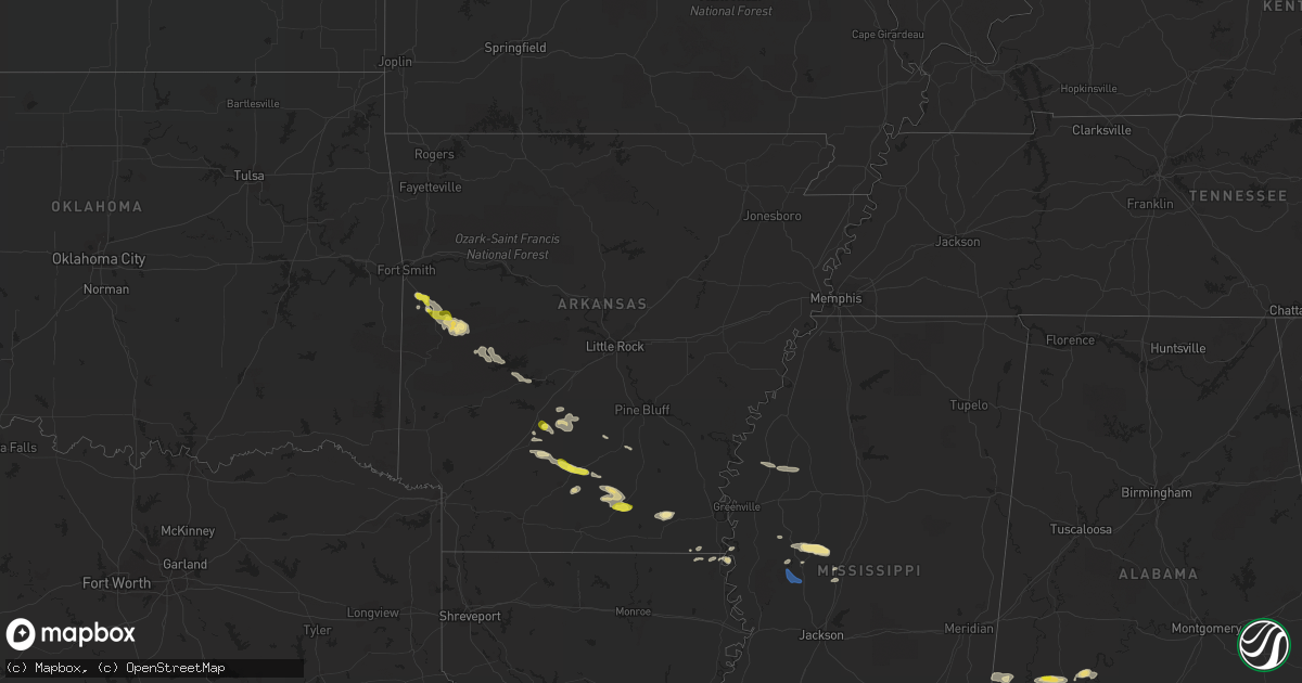
Hail Map in Arkansas on April 16, 2022
Get this storm
April 16 map
$229
one time, instant access
Download today. No call, no setup
Keep the $229
Bought the map and want the full workflow? Apply the entire $229 to a subscription within 7 days. None of it is wasted.
Every map, not just this one
This buys you this map. Subscription and you get every map we run, in the markets you choose from a few cities to whole states to nationwide. Plus real-time alerts the moment a storm fires.
Contact data
Name, contact info, occupancy, even credit band for addresses in the footprint. You go from where it hit to who to call.
Become the source they trust
Unlimited branding weather history reports on demand. You already have the documented answer ready for the property owner, and you are the one who showed up with it.
Property data and RoofTrace estimates
Pull up any address you have got, its value and the exact code rules for that jurisdiction, straight from One Click Code. Then RoofTrace estimates the squares, pitch, and roof value, priced the way you price.
Storm reports in Arkansas
Arkansas
| Date | Description |
|---|---|
| 04/16/20228:52 AM CDT | Trees were blown down at denby point campground. |
| 04/16/20227:12 AM CDT | Trees were down along manchester road... Shandy road... And highway 128. |
| 04/16/20225:20 AM CDT | At 1020 AM CDT, a severe thunderstorm was located 9 miles southwest of Thiel, or 12 miles south of Malvern, moving east at 30 mph. HAZARD...60 mph wind gusts and quarter size hail. SOURCE...Radar indicated. IMPACT...Hail damage to vehicles is expected. Expect wind damage to roofs, siding, and trees. Locations impacted include... Sheridan... Leola... Carthage... Prattsville... Poyen... Thiel... Jenkins Ferry State Park... Dogwood... Donaldson... Lono... Cross Roads in Grant County... Tulip... Slabtown... Buie... Willow... Brush Creek... Millerville... |
| 04/16/20224:46 AM CDT | At 946 AM CDT, a severe thunderstorm was located near Cardiff, or 11 miles east of Waldron, moving southeast at 40 mph. HAZARD...60 mph wind gusts and quarter size hail. SOURCE...Radar indicated. IMPACT...Hail damage to vehicles is expected. Expect wind damage to roofs, siding, and trees. Locations impacted include... Cardiff... Gravelly... Fourche Valley... Muddy Creek WMA... Union Hill... Wing... Chula... Olio... Cedar Creek... Gibbs... Waltreak... Bluffton... Rover... Nola... Harvey... Sims... Parks... Briggsville... Blue Ball... |
| 04/16/20224:40 AM CDT | At 939 AM CDT, a severe thunderstorm was located near Hilo, or 10 miles southeast of Hampton, moving east at 30 mph. HAZARD...60 mph wind gusts and quarter size hail. SOURCE...Radar indicated. IMPACT...Hail damage to vehicles is expected. Expect wind damage to roofs, siding, and trees. Locations impacted include... Ladelle... Prairie Grove... New Hope in Drew County... Vick... Valley... Mt Olive in Bradley County... Johnsonville... Sumpter... Lacey... |
| 04/16/20224:11 AM CDT | At 911 AM CDT, a severe thunderstorm was located near Snyder, or 7 miles northeast of Hamburg, moving east at 25 mph. HAZARD...60 mph wind gusts and half dollar size hail. SOURCE...Radar indicated. IMPACT...Hail damage to vehicles is expected. Expect wind damage to roofs, siding, and trees. This severe thunderstorm will be near... Snyder around 925 AM CDT. Portland around 940 AM CDT. Montrose around 945 AM CDT. Mcmillan Corner around 1010 AM CDT. Lake Village and Chicot Junction around 1015 AM CDT. |
| 04/16/20224:01 AM CDT | At 901 AM CDT, a severe thunderstorm was located near Lanark, or 8 miles east of Hampton, moving east at 35 mph. HAZARD...60 mph wind gusts and quarter size hail. SOURCE...Radar indicated. IMPACT...Hail damage to vehicles is expected. Expect wind damage to roofs, siding, and trees. Locations impacted include... Warren... Hampton... Hermitage... Wilmar... Harrell... Ingalls... Weeks... Hilo... Hampton Municipal Airport... Lanark... Banks... Tinsman... Carmel... Farmville... Johnsonville... Vick... Valley... Gravelridge... Mt Olive in Bradley County... Marsden... |
| 04/16/20223:48 AM CDT | At 848 AM CDT, a severe thunderstorm was located 8 miles northeast of Mount Ida, moving east at 35 mph. HAZARD...60 mph wind gusts and quarter size hail. SOURCE...Radar indicated. IMPACT...Hail damage to vehicles is expected. Expect wind damage to roofs, siding, and trees. Locations impacted include... Mountain Pine... Lake Ouachita State Park... Rockwell... Avant... Crystal Springs Landing... Mt Tabor... Sunshine... Fannie... Royal... Lena Landing Rec Area... Silver... Hamilton... Hempwallace... Crystal Springs... Story... Washita... Hurricane Grove... |
| 04/16/20223:31 AM CDT | At 831 AM CDT, a severe thunderstorm was located 7 miles north of Hampton, moving east at 30 mph. HAZARD...60 mph wind gusts and quarter size hail. SOURCE...Radar indicated. IMPACT...Hail damage to vehicles is expected. Expect wind damage to roofs, siding, and trees. Locations impacted include... Hampton... Harrell... Hampton Municipal Airport... Weeks... Ellisville... Lanark... Highland Industrial Park... Banks... Tinsman... Farmville... Orlando... Woodberry... |
| 04/16/20223:23 AM CDT | At 822 AM CDT, a severe thunderstorm was located near Ingalls, or 14 miles north of West Crossett, moving east at 30 mph. HAZARD...60 mph wind gusts and half dollar size hail. SOURCE...Radar indicated. IMPACT...Hail damage to vehicles is expected. Expect wind damage to roofs, siding, and trees. Locations impacted include... Ingalls... Vick... Mt Olive in Bradley County... Marsden... Johnsonville... Blanchton... Lacey... |
| 04/16/20223:17 AM CDT | At 817 AM CDT, a severe thunderstorm was located over Muddy Creek WMA, or 18 miles north of Mount Ida, moving east at 45 mph. HAZARD...60 mph wind gusts and quarter size hail. SOURCE...Radar indicated. IMPACT...Hail damage to vehicles is expected. Expect wind damage to roofs, siding, and trees. Locations impacted include... Plainview in Yell County... Fourche Valley... Muddy Creek WMA... Carter Cove Park... Wing... Chula... Macedonia in Yell County... Cedar Creek... Gibbs... Mt Tabor... Fannie... Bluffton... Rover... Silver... Fourche Junction... Onyx... Sims... Fourche Mountain Recreation Are... Briggsville... Story... |
| 04/16/20222:59 AM CDT | At 759 AM CDT, a severe thunderstorm was located near Lanark, or 12 miles southeast of Hampton, moving east at 30 mph. HAZARD...60 mph wind gusts and quarter size hail. SOURCE...Radar indicated. IMPACT...Hail damage to vehicles is expected. Expect wind damage to roofs, siding, and trees. Locations impacted include... Warren... Hermitage... Ingalls... Hilo... Lanark... Carmel... Farmville... Johnsonville... Vick... Gravelridge... Mt Olive in Bradley County... Jersey... Sumpter... |
| 04/16/20222:57 AM CDT | At 756 AM CDT, a severe thunderstorm was located near Bearden, or 11 miles northeast of Camden, moving east at 30 mph. HAZARD...60 mph wind gusts and quarter size hail. SOURCE...Radar indicated. IMPACT...Hail damage to vehicles is expected. Expect wind damage to roofs, siding, and trees. Locations impacted include... Amy... Holly Springs... |
| 04/16/20222:55 AM CDT | At 755 AM CDT, a severe thunderstorm was located near Bearden, or 13 miles northeast of Camden, moving east at 40 mph. HAZARD...60 mph wind gusts and quarter size hail. SOURCE...Radar indicated. IMPACT...Hail damage to vehicles is expected. Expect wind damage to roofs, siding, and trees. Locations impacted include... Fordyce... Bearden... Thornton... Harlow... Highland Industrial Park... Amy... Chambersville... Hopeville... Eagle Mills... Woodberry... Holly Springs... Millville... |
| 04/16/20222:53 AM CDT | At 753 AM CDT, a severe thunderstorm was located near Cardiff, or 10 miles northeast of Waldron, moving east at 40 mph. HAZARD...60 mph wind gusts and half dollar size hail. SOURCE...Radar indicated. IMPACT...Hail damage to vehicles is expected. Expect wind damage to roofs, siding, and trees. Locations impacted include... Booneville... Waldron... Magazine... Blue Mountain... Stonehouse Recreation Area... Cardiff... Gravelly... Fourche Valley... Muddy Creek WMA... Havana... Union Hill... Waveland... Olio... Waltreak... Bluffton... Nola... Harvey... Sugar Grove... Carolan... Briggsville... |
| 04/16/20222:24 AM CDT | At 723 AM CDT, a severe thunderstorm was located 7 miles east of Whelen Springs, or 19 miles northwest of Camden, moving east at 30 mph. HAZARD...60 mph wind gusts and quarter size hail. SOURCE...Radar indicated. IMPACT...Hail damage to vehicles is expected. Expect wind damage to roofs, siding, and trees. Locations impacted include... Sparkman... Whelen Springs... Amy... Tates Bluff... Pine Grove... Ouachita... Holly Springs... Vaden... |
| 04/16/20222:24 AM CDT | At 724 AM CDT, severe thunderstorms were located along a line extending from 3 miles south of Bloomer to near Huntington to near Hartford, moving southeast at 35 mph. HAZARD...60 mph wind gusts and half dollar size hail. SOURCE...Radar indicated. IMPACT...Hail damage to vehicles is expected. Expect wind damage to roofs, siding, and trees. Locations in or near the path include... Greenwood... Huntington... Midland... Washburn... Burnville... Fort Chaffee... Milltown... Arkola... Crossroads... Witcherville... Dayton... |
| 04/16/20222:19 AM CDT | At 719 AM CDT, a severe thunderstorm was located near Huntington, or 16 miles southwest of Charleston, moving east at 35 mph. HAZARD...60 mph wind gusts and quarter size hail. SOURCE...Radar indicated. IMPACT...Hail damage to vehicles is expected. Expect wind damage to roofs, siding, and trees. Locations impacted include... Booneville... Mansfield... Magazine... Cardiff... Echo... Barber... Lucas... Chismville... Sugar Grove... Carolan... Grayson... Glendale in Logan County... Ione... Elm Park... Liberty... |
| 04/16/20222:17 AM CDT | At 717 AM CDT, severe thunderstorms were located along a line extending from near Highland Industrial Park to Hilo, moving northeast at 25 mph. HAZARD...60 mph wind gusts and quarter size hail. SOURCE...Radar indicated. IMPACT...Hail damage to vehicles is expected. Expect wind damage to roofs, siding, and trees. Locations impacted include... Hampton... Hermitage... Harrell... Ingalls... Hilo... Hampton Municipal Airport... Lanark... Highland Industrial Park... Banks... Tinsman... Artesian... Delhi... Farmville... Locust Bayou... Valley... Gravelridge... Woodberry... Mt Olive in Bradley County... Marsden... Jersey... |
| 04/16/20222:06 AM CDT | At 705 AM CDT, severe thunderstorms were located along a line extending from near Rockport to 12 miles north of Sparkman to near Richwoods, moving southeast at 30 mph. HAZARD...Golf ball size hail and 60 mph wind gusts. SOURCE...Radar indicated. IMPACT...People and animals outdoors will be injured. Expect hail damage to roofs, siding, windows, and vehicles. Expect wind damage to roofs, siding, and trees. Locations impacted include... Malvern... Rockport... Leola... Sparkman... Carthage... Prattsville... Poyen... Perla... Jenkins Ferry State Park... Thiel... Donaldson... Magnet Cove... Lono... Tulip... Ouachita... Gifford... Dalark... Fenter... Princeton... Social Hill...This includes Interstate 30 between mile markers 87 and 101. |
| 04/16/20221:52 AM CDT | At 652 AM CDT, a severe thunderstorm was located over Pocola, moving east at 40 mph. HAZARD...60 mph wind gusts and quarter size hail. SOURCE...Radar indicated. IMPACT...Hail damage to vehicles is expected. Expect wind damage to roofs, siding, and trees. Locations in or near the path include... Fort Smith... Greenwood... Pocola... Spiro... Arkoma... Hackett... Huntington... Bonanza... Midland... Cameron... Excelsior... Washburn... Burnville... Fort Chaffee... Jenny Lind... Rock Island... Arkola... Crossroads... Witcherville... Liberty...This includes Interstate 540 between mile markers 12 and 14. |
| 04/16/20221:25 AM CDT | At 624 AM CDT, a severe thunderstorm was located near DeGray Lake State Park, or 9 miles north of Arkadelphia, moving east at 40 mph. THIS IS A DESTRUCTIVE STORM! HAZARD...Three inch hail and 60 mph wind gusts. SOURCE...Radar indicated. IMPACT...People and animals outdoors will be severely injured. Expect shattered windows, extensive damage to roofs, siding, and vehicles. Locations impacted include... Arkadelphia... Malvern... Rockport... Amity... Caddo Valley... Perla... Gum Springs in Clark County... Richwoods... Meyers... Lofton... DeGray Lake State Park... Rockwell... Donaldson... Friendship... Bismarck... Alpine... Curtis... De Roche... Point Cedar... Dalark...This includes Interstate 30 between mile markers 64 and 98. |
| 04/16/20221:03 AM CDT | At 603 AM CDT, a severe thunderstorm was located near Lavaca, or near Charleston, moving east at 40 mph. HAZARD...60 mph wind gusts and half dollar size hail. SOURCE...Radar indicated. IMPACT...Hail damage to vehicles is expected. Expect wind damage to roofs, siding, and trees. Locations impacted include... Booneville... Paris... Magazine... Subiaco... Ratcliff... Caulksville... Wilkins... Roseville... Carbon City... Driggs... Chismville... |
| 04/16/202212:45 AM CDT | At 545 AM CDT, a severe thunderstorm was located near Van Buren, moving east at 40 mph. HAZARD...Half dollar size hail. SOURCE...Radar indicated. IMPACT...Damage to vehicles is expected. Locations in or near the path include... Fort Smith... Van Buren... Charleston... Alma... Barling... Lavaca... Mulberry... Dyer... Branch... Denning... Rudy... Fort Smith Regional Airport... Bloomer... Fort Chaffee... Kibler... Central City... Concord... Shibley... Vesta... Cecil...This includes the following highways, Interstate 40 in Arkansas between mile markers 2 and 21. Interstate 540 between mile markers 1 and 11. Interstate 49 between mile markers 22 and 26. |
| 04/16/202212:40 AM CDT | At 539 AM CDT, severe thunderstorms were located along a line extending from 13 miles northwest of Mountain Pine to near Lake Ouachita State Park to near Meyers to 9 miles west of Lofton to near Glenwood, moving southeast at 40 mph. HAZARD...60 mph wind gusts and half dollar size hail. SOURCE...Radar indicated. IMPACT...Hail damage to vehicles is expected. Expect wind damage to roofs, siding, and trees. Locations impacted include... Hot Springs... Hot Springs Village... Arkadelphia... Malvern... Mount Ida... Glenwood... Mountain Pine... Rockport... Amity... Caddo Valley... Norman... Perla... Lonsdale... Gum Springs in Clark County... Meyers... Jessieville... Lake Ouachita State Park... Lofton... Rockwell... DeGray Lake State Park...This includes Interstate 30 between mile markers 62 and 106. |
| 04/16/202212:08 AM CDT | At 508 AM CDT, a severe thunderstorm was located over Brushy, moving east at 35 mph. HAZARD...Quarter size hail. SOURCE...Radar indicated. IMPACT...Damage to vehicles is expected. Locations in or near the path include... Fort Smith... Van Buren... Sallisaw... Cedarville... Alma... Barling... Muldrow... Roland... Marble City... Moffett... Rudy... Brushy... Figure Five... Brushy Lake State Park... Short... Fort Smith Regional Airport... Kibler... Concord... Shibley... Uniontown...This includes the following highways, Interstate 40 in Arkansas between mile markers 0 and 13. Interstate 40 in Oklahoma between mile markers 322 and 328. Interstate 540 between mile markers 1 and 9. Interstate 49 between mile markers 22 and 23. |
| 04/15/202211:58 PM CDT | At 457 AM CDT, severe thunderstorms were located along a line extending from near Fourche Valley to near Muddy Creek WMA to 6 miles north of Mauldin to near Oden to near Opal, moving southeast at 30 mph. HAZARD...Golf ball size hail and 60 mph wind gusts. SOURCE...Radar indicated. IMPACT...People and animals outdoors will be injured. Expect hail damage to roofs, siding, windows, and vehicles. Expect wind damage to roofs, siding, and trees. Locations impacted include... Mount Ida... Mountain Pine... Norman... Oden... Little Missouri Falls Recreatio... Meyers... Lake Ouachita State Park... Mauldin... Albert Pike Recreation Area... Muddy Creek WMA... Stonehouse Recreation Area... Opal... Mimosa... Gravelly... Fourche Valley... Avant... Black Springs... Acorn... Big Fork... Wing... |
| 04/15/202211:14 PM CDT | At 414 AM CDT, severe thunderstorms were located along a line extending from near Cardiff to 7 miles southeast of Waldron to near Beauchamp, moving southeast at 35 mph. HAZARD...Ping pong ball size hail and 60 mph wind gusts. SOURCE...Radar indicated. IMPACT...People and animals outdoors will be injured. Expect hail damage to roofs, siding, windows, and vehicles. Expect wind damage to roofs, siding, and trees. Locations impacted include... Waldron... Mount Ida... Oden... Beauchamp... Cardiff... Opal... Mimosa... Gravelly... Fourche Valley... Mauldin... Muddy Creek WMA... Olio... Bluffton... Pine Ridge... Boles... Story... Union Hill... Chula... Cedar Creek... Gibbs... |
| 04/15/202211:04 PM CDT | At 404 AM CDT, a severe thunderstorm was located 4 miles east of Springdale, moving east at 40 mph. HAZARD...Half dollar size hail. SOURCE...Radar indicated. IMPACT...Damage to vehicles is expected. Locations in or near the path include... Fayetteville... Springdale... Berryville... Eureka Springs... Lowell... Green Forest... Bethel Heights... Hindsville... Rudd... Forum... Hobbs State Park... Clifty... Withrow Springs State Park... War Eagle... Urbanette... Rule... Goshen... Metalton... Connor... Best... |
| 04/15/202210:53 PM CDT | At 352 AM CDT, severe thunderstorms were located along a line extending from 7 miles east of Heavener Runestone State Park to Morgan Springs to near Oliver to 6 miles east of Echo, moving south at 20 mph. HAZARD...60 mph wind gusts and half dollar size hail. SOURCE...Radar indicated. IMPACT...Hail damage to vehicles is expected. Expect wind damage to roofs, siding, and trees. Locations impacted include... Booneville... Waldron... Mansfield... Magazine... Blue Mountain... Beauchamp... Stonehouse Recreation Area... Cardiff... Echo... Oliver... Morgan Springs... Mount Magazine... Bates... Barber... Black Fork... Winfield... Olio... Chismville... Liberty... Grayson... |
| 04/15/202210:42 PM CDT | At 341 AM CDT, severe thunderstorms were located along a line extending from 6 miles northeast of Heavener Runestone State Park to near Morgan Springs to near Oliver to near Washburn, moving south at 20 mph. HAZARD...60 mph wind gusts and quarter size hail. SOURCE...Radar indicated. IMPACT...Hail damage to vehicles is expected. Expect wind damage to roofs, siding, and trees. Locations impacted include... Booneville... Waldron... Mansfield... Magazine... Blue Mountain... Beauchamp... Stonehouse Recreation Area... Cardiff... Echo... Oliver... Morgan Springs... Mount Magazine... Bates... Barber... Black Fork... Winfield... Olio... Chismville... Liberty... Grayson... |
| 04/15/202210:09 PM CDT | At 309 AM CDT, a severe thunderstorm was located 3 miles north of Mc Curtain, moving southeast at 30 mph. HAZARD...60 mph wind gusts and quarter size hail. SOURCE...Radar indicated. IMPACT...Hail damage to vehicles is expected. Expect wind damage to roofs, siding, and trees. Locations in or near the path include... Poteau... Panama... Wister... Howe... Keota... Mccurtain... Bokoshe... Cameron... Mc Curtain... Lequire... Shady Point... Kanima... Milton... |
| 04/15/20229:49 PM CDT | At 249 AM CDT, a severe thunderstorm was located over Spiro, moving southeast at 30 mph. HAZARD...Ping pong ball size hail. SOURCE...Radar indicated. IMPACT...People and animals outdoors will be injured. Expect damage to roofs, siding, windows, and vehicles. Locations in or near the path include... Fort Smith... Greenwood... Pocola... Spiro... Panama... Hackett... Hartford... Huntington... Bonanza... Midland... Cameron... Excelsior... Washburn... Burnville... Jenny Lind... Rock Island... Arkola... Crossroads... Witcherville... Dayton...This includes Interstate 540 near mile marker 14. |
| 04/15/20229:20 PM CDT | At 220 AM CDT, a severe thunderstorm was located 6 miles southwest of Gans, moving east at 25 mph. HAZARD...Golf ball size hail. SOURCE...Radar indicated. IMPACT...People and animals outdoors will be injured. Expect damage to roofs, siding, windows, and vehicles. Locations in or near the path include... Fort Smith... Pocola... Spiro... Arkoma... Hackett... Bonanza... Gans... Rock Island... Cowlington... Scullyville... Braden... Rye Hill... Jenson... Cottonwood...This includes Interstate 540 between mile markers 12 and 14. |
| 04/15/20229:14 PM CDT | At 214 AM CDT, a severe thunderstorm was located over Midland, or 14 miles east of Poteau, moving east at 35 mph. HAZARD...Ping pong ball size hail. SOURCE...Radar indicated. IMPACT...People and animals outdoors will be injured. Expect damage to roofs, siding, windows, and vehicles. Locations impacted include... Booneville... Waldron... Mansfield... Cardiff... Echo... Barber... Lucas... Carolan... Grayson... Ione... Elm Park... Liberty... Hon... |
| 04/15/20228:44 PM CDT | At 144 AM CDT, a severe thunderstorm was located over Panama, moving east at 35 mph. HAZARD...Ping pong ball size hail. SOURCE...Radar indicated. IMPACT...People and animals outdoors will be injured. Expect damage to roofs, siding, windows, and vehicles. Locations in or near the path include... Poteau... Spiro... Panama... Hackett... Hartford... Huntington... Midland... Cameron... Shady Point... Rock Island... Patterson... Arkola... Crossroads... Witcherville... Dayton... Jenson... |
All States Impacted by Hail Map on April 16, 2022
Cities Impacted by Hail Map on April 16, 2022
- Pine Hill, AL
- Waynesboro, MS
- Hampton, AR
- Bearden, AR
- Richton, MS
- Mayersville, MS
- Lake Providence, LA
- Gurdon, AR
- Banks, AR
- Jersey, AR
- Hermitage, AR
- Harrell, AR
- Tchula, MS
- Lexington, MS
- Yazoo City, MS
- Thomasville, AL
- Mansfield, AR
- Huntington, AR
- Greenwood, AR
- Shubuta, MS
- Oak Grove, LA
- Vanderpool, TX
- Camden, AR
- Kingsland, AR
- Rison, AR
- Eudora, AR
- Leola, AR
- Booneville, AR
- Leakesville, MS
- State Line, MS
- Uriah, AL
- Waldron, AR
- Hamburg, AR
- Millry, AL
- Chatom, AL
- Frankville, AL
- Wagarville, AL
- Saint Stephens, AL
- Jackson, AL
- Leroy, AL
- Cleveland, MS
- Laurel, MS
- Story, AR
- Mount Ida, AR
- Royal, AR
- Hot Springs National Park, AR
- Pearcy, AR
- Ovett, MS
- Gainestown, AL
- Sims, AR
- Wiggins, MS
- Toxey, AL
- Gilbertown, AL
- Needham, AL
- Arkadelphia, AR
- Wilmot, AR
- Annapolis, MD
- Harvey, AR
- Heidelberg, MS
- Greenville, MS
- Glen Allan, MS
- Cherry Hill, NJ
- Franklin, AL
- Chidester, AR
- Grand Ridge, FL
- Altha, FL
- Blountstown, FL
- Bristol, FL
- Vinegar Bend, AL
- Deer Park, AL
- Citronelle, AL
- Belzoni, MS
- Vaughan, MS
- Pickens, MS
- Ellisville, MS
- Doddsville, MS
- Minter City, MS
- Ruleville, MS
- Melvin, AL
- Sparkman, AR
- Carthage, AR
- Malvern, AR
- Neely, MS
- Silver City, MS
- Mount Laurel, NJ
- Smyrna, DE
- Cheswold, DE
- Dover, DE
- Clayton, DE


