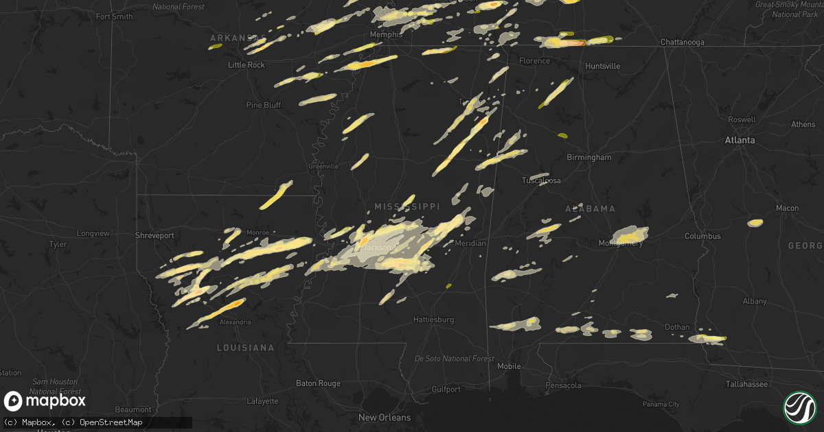
Hail Map in Mississippi on March 31, 2016
Get this storm
March 31 map
$229
one time, instant access
Download today. No call, no setup
Keep the $229
Bought the map and want the full workflow? Apply the entire $229 to a subscription within 7 days. None of it is wasted.
Every map, not just this one
This buys you this map. Subscription and you get every map we run, in the markets you choose from a few cities to whole states to nationwide. Plus real-time alerts the moment a storm fires.
Contact data
Name, contact info, occupancy, even credit band for addresses in the footprint. You go from where it hit to who to call.
Become the source they trust
Unlimited branding weather history reports on demand. You already have the documented answer ready for the property owner, and you are the one who showed up with it.
Property data and RoofTrace estimates
Pull up any address you have got, its value and the exact code rules for that jurisdiction, straight from One Click Code. Then RoofTrace estimates the squares, pitch, and roof value, priced the way you price.
Storm reports in Mississippi
Mississippi
| Date | Description |
|---|---|
| 03/31/20166:57 PM CDT | Multiple trees and powerlines down in the area. |
| 03/31/20166:55 PM CDT | Several trees and powerlines down across the southern third of the county. Four trees down on homes. |
| 03/31/20166:53 PM CDT | A local report indicates 1.00 inch wind near ROME |
| 03/31/20166:43 PM CDT | Trees down. Shingles blown off of multiple homes. |
| 03/31/20166:41 PM CDT | Trees downed on us hwy 49 south of florence. Report via social media. |
| 03/31/20166:40 PM CDT | A local report indicates 1.00 inch wind near 3 S TUPELO |
| 03/31/20166:30 PM CDT | Golf ball sized hail and about 20 mph wind gust in amory |
| 03/31/20166:25 PM CDT | Half dollar sized hail. |
| 03/31/20166:22 PM CDT | Roof off a house on hughes road. Several trees snapped along lake lowndes road. |
| 03/31/20166:18 PM CDT | This tornado began southeast of columbus on frisco rd. It continued northeast... Snapping numerous trees. The tornado continued northeast crossing pritchard ln and then i (ja |
| 03/31/20166:18 PM CDT | Trees downed in the city of clinton |
| 03/31/20166:11 PM CDT | Dime to quarter size hail |
| 03/31/20166:01 PM CDT | Tree downed blocking ms hwy 27 at old port gibson rd |
| 03/31/20165:58 PM CDT | Several trees downed along ms hwy 27. |
| 03/31/20165:58 PM CDT | Tree downed on a house along cayuga rd |
| 03/31/20165:48 PM CDT | Near montpelier |
| 03/31/20165:42 PM CDT | A local report indicates 1.00 inch wind near LENA |
| 03/31/20165:34 PM CDT | Quarter sized hail. Most of the hail was dime to nickel sized hail. |
| 03/31/20165:34 PM CDT | Wind gust of 50-60 mph in hernando with penny to nickel size hail. |
| 03/31/20165:27 PM CDT | Reported south of maben |
| 03/31/20165:21 PM CDT | Reported in the blythe creek area |
| 03/31/20165:12 PM CDT | Tree downed at natchez trace parkway and ms hwy 43 |
| 03/31/20165:08 PM CDT | Several trees downed in the deerfield community |
| 03/31/20165:07 PM CDT | Quarter size hail reported at the germantown high school. |
| 03/31/20165:05 PM CDT | Large tree down across hwy 19. |
| 03/31/20165:05 PM CDT | Several trees and powerlines down near hwy 51 and yandell rd area. |
| 03/31/20165:05 PM CDT | Golf ball size hail reported off of hwy 491 near house. |
| 03/31/20165:05 PM CDT | Nickel to quarter size hail reported in hwy 51 and yandell rd area. |
| 03/31/20165:04 PM CDT | Tree down on a house near hwy 491 and cr 4300. |
| 03/31/20165:00 PM CDT | Several large trees down in deerfield subdivision. |
| 03/31/20165:00 PM CDT | Trees down on myrleville road. |
| 03/31/20164:59 PM CDT | Shingles were damaged and removed from a funeral home just north of town. |
| 03/31/20164:54 PM CDT | Dime to quarter size hail reported near deemer rd and hwy 492. |
| 03/31/20164:53 PM CDT | Golf ball sized hail fell in williams cove. |
| 03/31/20164:53 PM CDT | Golf ball size hail reported on union madden rd. |
| 03/31/20164:50 PM CDT | Trees and limbs down on old hwy 49 and banks lane. |
| 03/31/20164:50 PM CDT | A local report indicates 1.00 inch wind near UNION |
| 03/31/20164:50 PM CDT | Wall of a barn and a fence blown down. |
| 03/31/20164:46 PM CDT | Several trees down in this area. |
| 03/31/20164:45 PM CDT | A local report indicates 1.75 inch wind near 6 E SEBASTOPOL |
| 03/31/20164:44 PM CDT | A local report indicates 1.00 inch wind near SANDERSVILLE |
| 03/31/20164:42 PM CDT | Trees down on link rd. |
| 03/31/20164:28 PM CDT | A local report indicates 1.75 inch wind near BOLTON |
| 03/31/20164:24 PM CDT | Hail ranging from pea to golf ball size on i-20 |
| 03/31/20164:08 PM CDT | Tree downed on utility equipment along ms hwy 14 |
| 03/31/20164:06 PM CDT | A local report indicates 1.00 inch wind near 8 SW KOSCIUSKO |
| 03/31/20162:52 PM CDT | Tree down on hwy 27. |
| 03/31/20162:48 PM CDT | Tree down on hwy 184 blocking traffic. |
| 03/31/20168:32 AM CDT | Reports of numerous trees down/uprooted along the north side of us highway 98 in perry county. Time estimated from radar data. |
| 03/31/20167:56 AM CDT | Trees and power lines down near aldon road and stonfield drive. Possible tornado. |
| 03/31/20167:54 AM CDT | Several trees down at the upper elementary school. Possible tornado. |
| 03/31/20167:53 AM CDT | This tornado touched down near talowah rd where it uprooted a couple of trees and caused some minor roof damage to a home. The tornado continued east northeast uprootin |
| 03/31/20161:38 AM CDT | Picture and report relayed via social media. |
| 03/31/20161:25 AM CDT | A billboard was blown down.also several trees were blown down along highway 49. |
| 03/30/20167:39 PM CDT | Trees down |
| 03/30/20167:32 PM CDT | Several trees down around the shongelo community. |
| 03/30/20167:26 PM CDT | Numerous trees downed across the county... Including along ms hwy 37 and ms hwy 35 n. The skirting was blown off a mobile home. Small hail was also reported. |
| 03/30/20167:19 PM CDT | Quarter sized hail in the old union commmunity with cg lightning and very heavy rain. |
| 03/30/20167:18 PM CDT | Trees were blown down |
| 03/30/20167:10 PM CDT | Numerous trees snapped and uprooted near the intersection of highway 13 and 43. Large tree fell on a home and damaged the roof. Estimated max winds of 80 mph. |
| 03/30/20167:10 PM CDT | Dime to golf ball size hail reported |
| 03/30/20167:10 PM CDT | Some trees and power lines down. |
| 03/30/20167:07 PM CDT | Multiple trees down. Multiple roads closed due to debris. Some structure damage from trees. |
| 03/30/20167:05 PM CDT | Along ms hwy 18 south of brandon. Relayed via social media |
| 03/30/20167:00 PM CDT | Quarter sized hail reported in tutwiler |
All States Impacted by Hail Map on March 31, 2016
Cities Impacted by Hail Map on March 31, 2016
- Wellington, IL
- Milford, IL
- Zwingle, IA
- Bernard, IA
- La Motte, IA
- Heber Springs, AR
- Natchitoches, LA
- Fredericksburg, TX
- Comfort, TX
- Brownsville, TN
- Brandon, MS
- Mendenhall, MS
- Morton, MS
- Florence, MS
- Raleigh, MS
- Braxton, MS
- Donalsonville, GA
- Columbia, TN
- Mount Pleasant, TN
- Patoka, IN
- Pulaski, MS
- Provencal, LA
- Elora, TN
- Flintville, TN
- Huntland, TN
- Union, MS
- Little Rock, MS
- Vernon, IL
- Alma, IL
- Patoka, IL
- Kinmundy, IL
- Leakey, TX
- McRae, AR
- Griffithville, AR
- Searcy, AR
- Sherwood, AR
- Little Rock Air Force Base, AR
- Beebe, AR
- Ward, AR
- Cabot, AR
- Jacksonville, AR
- North Little Rock, AR
- Austin, AR
- Hermanville, MS
- Vicksburg, MS
- Utica, MS
- Port Gibson, MS
- Drummonds, TN
- Millington, TN
- Samson, AL
- Coffee Springs, AL
- Geneva, AL
- Madison, MS
- Lamar, MS
- Bentley, LA
- Dry Prong, LA
- Pollock, LA
- Gordon, AL
- Scotts Hill, TN
- Huron, TN
- Reagan, TN
- Lexington, TN
- Magee, MS
- Hernando, MS
- Marianna, AR
- Moro, AR
- Brackettville, TX
- Northport, AL
- Buhl, AL
- Tuscaloosa, AL
- Coker, AL
- Crystal City, TX
- Butler, GA
- Reynolds, GA
- Montgomery, AL
- Forest, MS
- Lake, MS
- Coushatta, LA
- Cedarbluff, MS
- Osceola, AR
- Tutwiler, MS
- Mound Bayou, MS
- Drew, MS
- Ingraham, IL
- Clay City, IL
- Yazoo City, MS
- Benton, MS
- Olla, LA
- Amory, MS
- Robeline, LA
- Natchez, LA
- Sweeny, TX
- Van Vleck, TX
- Ruston, LA
- Choudrant, LA
- Michigan City, MS
- Ashland, MS
- Tallassee, AL
- Shorter, AL
- Millbrook, AL
- Prattville, AL
- Wetumpka, AL
- Coosada, AL
- Elmore, AL
- Tuskegee, AL
- Pike Road, AL
- Eclectic, AL
- Winnsboro, LA
- Delhi, LA
- Uvalde, TX
- Westpoint, TN
- Iron City, TN
- Bethel Springs, TN
- Adamsville, TN
- Selmer, TN
- Saline, LA
- Mansfield, LA
- Pelican, LA
- Prairie, MS
- Halls, TN
- Ripley, TN
- Minor Hill, TN
- Five Points, TN
- Marion, AR
- Dennis, MS
- Tishomingo, MS
- Iuka, MS
- Clarksdale, MS
- Monticello, MS
- Silver Creek, MS
- Batesville, TX
- La Pryor, TX
- Coffeeville, AL
- Toxey, AL
- Gilbertown, AL
- Sallis, MS
- Camden, MS
- Kosciusko, MS
- McIntosh, AL
- Deer Park, AL
- Citronelle, AL
- Middleton, TN
- Nettleton, MS
- Nashville, IL
- Ward, AL
- Pennington, AL
- Toone, TN
- Whiteville, TN
- Satartia, MS
- Moorhead, MS
- Somerville, TN
- Inverness, MS
- Itta Bena, MS
- Schlater, MS
- Lolita, TX
- Canton, MS
- Decatur, MS
- Conehatta, MS
- Louisville, MS
- Vinegar Bend, AL
- Moulton, AL
- Haleyville, AL
- Danville, AL
- Kennedy, AL
- Millport, AL
- Ethelsville, AL
- Edwards, MS
- De Witt, AR
- Elaine, AR
- Ethel, AR
- Saint Charles, AR
- Clinton, IA
- Camanche, IA
- Bentonia, MS
- Vance, MS
- Lambert, MS
- Merigold, MS
- Redwood, MS
- Vernon, AL
- Sulligent, AL
- Guin, AL
- Steens, MS
- Fayette, AL
- Winfield, AL
- Bloomington, IN
- Ellettsville, IN
- Munford, TN
- Aberdeen, MS
- Sikes, LA
- Dodson, LA
- Philadelphia, MS
- Collinsville, MS
- Burnsville, MS
- Goldonna, LA
- Jonesboro, LA
- Castor, LA
- Many, LA
- Montgomery, LA
- Stanton, TN
- Wisner, LA
- Tullos, LA
- Fort Necessity, LA
- Georgetown, LA
- Harrisonburg, LA
- Kelly, LA
- Columbia, LA
- Gilbert, LA
- Enterprise, LA
- Winnfield, LA
- Brewton, AL
- Castleberry, AL
- Ardmore, TN
- Fayetteville, TN
- Taft, TN
- Ringgold, LA
- Humnoke, AR
- Stuttgart, AR
- Sardis, AL
- Minter, AL
- Union Grove, WI
- Sturtevant, WI
- Kenosha, WI
- Jakin, GA
- Iron City, GA
- Colquitt, GA
- Brinson, GA
- Medina, TX
- Shiloh, TN
- Michie, TN
- Stantonville, TN
- Morris Chapel, TN
- Savannah, TN
- Wheatfield, IN
- Hebron, IN
- Linton, IN
- Jasonville, IN
- Lena, LA
- Colfax, LA
- Mora, LA
- Holly Grove, AR
- Floresville, TX
- Adkins, TX
- Elmendorf, TX
- La Vernia, TX
- San Antonio, TX
- Keiser, AR
- Mooreville, MS
- Verona, MS
- Tupelo, MS
- Newhebron, MS
- Prentiss, MS
- Glen, MS
- McCrory, AR
- Wynne, AR
- Marion, AL
- Plantersville, AL
- Campti, LA
- Pelahatchie, MS
- Smithville, MS
- Okolona, MS
- Houlka, MS
- Caraway, AR
- Luxora, AR
- Lepanto, AR
- Etowah, AR
- Harrisburg, AR
- Marked Tree, AR
- Trumann, AR
- Fort Valley, GA
- Roberta, GA
- Luray, TN
- Jacks Creek, TN
- Lexington, AL
- Loretto, TN
- Leoma, TN
- Prospect, TN
- Lester, AL
- Anderson, AL
- Goodspring, TN
- Hickory Ridge, AR
- Augusta, AR
- Brighton, TN
- Bastrop, LA
- Eros, LA
- Chatham, LA
- Calhoun, LA
- Quitman, LA
- Mason, TN
- Bolton, MS
- Memphis, TN
- Lake Cormorant, MS
- Forrest City, AR
- Hughes, AR
- Arlington, TN
- Cordova, TN
- Oakland, TN
- Eads, TN
- Red Bay, AL
- Tremont, MS
- Golden, MS
- Devine, TX
- Moore, TX
- Bigfoot, TX
- Lytle, TX
- Poteet, TX
- Somerset, TX
- Natalia, TX
- Valparaiso, IN
- McKenzie, AL
- Hickory, MS
- Hamburg, AR
- Portland, AR
- Parkdale, AR
- Princeton, IA
- Spencer, IN
- Gosport, IN
- Von Ormy, TX
- Andalusia, AL
- Lena, MS
- Hall Summit, LA
- Decaturville, TN
- Sardis, TN
- Henderson, TN
- Conway, AR
- Vilonia, AR
- Uniontown, AL
- Newbern, AL
- Faunsdale, AL
- Randolph, AL
- Lawley, AL
- De Kalb, MS
- Thomaston, AL
- Barksdale, TX
- Baskin, LA
- Rayville, LA
- Mangham, LA
- Grayson, LA
- Monroe, LA
- Louin, MS
- Clarendon, AR
- Roe, AR
- Marthaville, LA
- Sullivan, IN
- Worthington, IN
- Fulton, MS
- Chesterton, IN
- Cherry Valley, AR
- Chancellor, AL
- Blakely, GA
- Holly Springs, MS
- Walnut, MS
- Falkner, MS
- Clopton, AL
- Skipperville, AL
- Ariton, AL
- Clio, AL
- Newellton, LA
- Collins, MS
- Eupora, MS
- Saltillo, MS
- Shannon, MS
- Plantersville, MS
- Houston, MS
- Mantee, MS
- Mantachie, MS
- Calhoun City, MS
- Woodland, MS
- Center Point, TX
- Macon, MS
- West Monroe, LA
- Florala, AL
- Covington, TN
- Atoka, TN
- Turrell, AR
- Evergreen, AL
- Camp Wood, TX
- Dickinson, TX
- La Marque, TX
- Rosharon, TX
- Liverpool, TX
- Alvin, TX
- Santa Fe, TX
- Manteno, IL
- Edinburgh, IN
- Shelbyville, IN
- Franklin, IN
- Columbus, MS
- Oxford, MS
- Abbeville, MS
- Dugger, IN
- Lexa, AR
- Brickeys, AR
- Robinsonville, MS
- Tunica, MS
- Little River, AL
- Uriah, AL
- New Albany, MS
- Flora, MS
- Hampshire, TN
- Tallulah, LA
- Opp, AL
- Carlyle, IL
- Sandoval, IL
- Vandalia, IL
- Carlisle, AR
- Wabbaseka, AR
- Hohenwald, TN
- Hobart, IN
- Westville, IN
- Michigan City, IN
- Rocksprings, TX
- Gillett, AR
- Almyra, AR
- Pearsall, TX
- Ackerman, MS
- Flatwoods, LA
- Ingram, TX
- Lutts, TN
- Counce, TN
- Waterloo, AL
- Collinwood, TN
- Sicily Island, LA
- Aimwell, LA
- Atlanta, LA
- Jena, LA
- Cloutierville, LA
- Double Springs, AL
- Valley Park, MS
- Terry, MS
- Raymond, MS
- Yuma, TN
- Leesville, LA
- Myrtle, MS
- Rose Bud, AR
- Greensboro, AL
- Linden, AL
- Sweet Water, AL
- Dyersburg, TN
- Saint Joseph, LA
- Clinton, MS
- Daleville, AL
- Kinston, AL
- Black, AL
- Hartford, AL
- Tilden, TX
- Bainbridge, GA
- Linden, TN
- Pinson, TN
- Cottondale, AL
- Quitman, AR
- Mount Vernon, AR
- Kerrville, TX
- Tyronza, AR
- Bailey, MS
- Meridian, MS
- Daleville, MS
- Caledonia, MS
- Gattman, MS
- Hamilton, MS
- Mathiston, MS
- Maben, MS
- Sturgis, MS
- Mercer, TN
- Bassett, AR
- Joiner, AR
- Gilmore, AR
- Crawfordsville, AR
- Denmark, TN
- Frenchmans Bayou, AR
- Pleasant Hill, LA
- Thomasville, AL
- Campbell, AL
- Medon, TN
- Jackson, MS
- Ridgeland, MS
- Shobonier, IL
- Bald Knob, AR
- Florence, AL
- Elkmont, AL
- Saint Joseph, TN
- Killen, AL
- Pulaski, TN
- Flora, IL
- Olivehill, TN
- Waynesboro, TN
- Clifton, TN
- Bath Springs, TN
- Kingsford Heights, IN
- Union Mills, IN
- Pearl, MS
- Byram, MS
- Richland, MS
- Flowood, MS
- Crawford, MS
- Weir, MS
- Orrville, AL
- Spruce Pine, AL
- Marvell, AR
- Oak Ridge, LA
- Casscoe, AR
- Ramer, TN
- Guys, TN
- Racine, WI
- Rienzi, MS
- Starkville, MS
- Pheba, MS
- West Point, MS
- New Site, MS
- Cherokee, AL
- Grand Junction, TN
- Corinth, MS
- Concan, TX
- Texas City, TX
- Phil Campbell, AL
- Del Rio, TX
- Cordova, IL
- Newton, MS
- Tuscola, IL
- Enville, TN
- Carson, MS
- Cottonwood, AL
- Ashford, AL
- Dothan, AL
- Hodges, AL
- Friendship, TN
- Hickory Valley, TN
- Saulsbury, TN
- Bolivar, TN
- Hornsby, TN
- Gleason, TN
- Cleveland, MS
- Fisher, LA
- Converse, LA
- Georgiana, AL
- Greenville, AL
- Midfield, TX
- Blessing, TX
- Hitchcock, TX
- Judsonia, AR
- Lowell, IN
- Centreville, AL
- Beverly Shores, IN
- Cash, AR
- Jonesboro, AR
- Nineveh, IN
- Flat Rock, IN
- Trout, LA
- Taylorsville, MS
- Beech Bluff, TN
- Hunt, TX
- Crump, TN
- De Valls Bluff, AR
- Pontotoc, MS
- Gallion, AL
- Schneider, IN
- Marmaduke, AR
- Lawrence, MS
- Bay Springs, MS
- Walnut Grove, MS
- Crystal Springs, MS
- Stockton, AL
- Jackson, AL
- Atmore, AL
- Carthage, MS
- York, AL
- Dixons Mills, AL
- Kelso, TN
- Owensville, IN
- Griffin, IN
- Town Creek, AL
- Russell, AR
- Princeton, IN
- Magnolia, AL
- Pine Hill, AL
- Jackson, TN
- Perryville, AR
- Trinity, AL
- Decatur, AL
- Carlisle, IN
- Noxapater, MS
- Preston, MS
- Shuqualak, MS
- Aliceville, AL
- Thomson, IL
- Chadwick, IL
- Earle, AR
- Pansey, AL
- Brinkley, AR
- Needham, AL
- Mize, MS
- Sebastopol, MS
- Portage, IN
- Santa Fe, TN
- Salem, WI
- Silver Lake, WI
- Burlington, WI
- Twin Lakes, WI
- Fulton, IL
- Bigelow, AR
- Houston, AR
- Marion, LA
- Nesbit, MS
- Lawrenceburg, TN
- Heidelberg, MS
- Laurel, MS
- Jasper, AL
- Cordova, AL
- Unionville, IN


