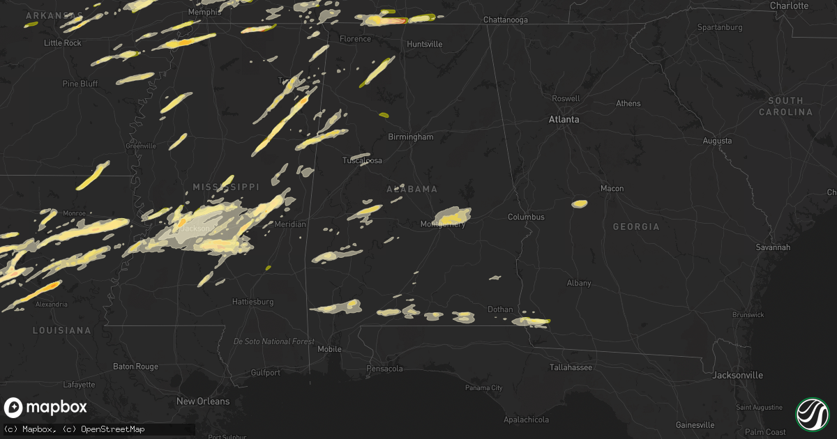
Hail Map in Alabama on March 31, 2016
Get this storm
March 31 map
$229
one time, instant access
Download today. No call, no setup
Keep the $229
Bought the map and want the full workflow? Apply the entire $229 to a subscription within 7 days. None of it is wasted.
Every map, not just this one
This buys you this map. Subscription and you get every map we run, in the markets you choose from a few cities to whole states to nationwide. Plus real-time alerts the moment a storm fires.
Contact data
Name, contact info, occupancy, even credit band for addresses in the footprint. You go from where it hit to who to call.
Become the source they trust
Unlimited branding weather history reports on demand. You already have the documented answer ready for the property owner, and you are the one who showed up with it.
Property data and RoofTrace estimates
Pull up any address you have got, its value and the exact code rules for that jurisdiction, straight from One Click Code. Then RoofTrace estimates the squares, pitch, and roof value, priced the way you price.
Storm reports in Alabama
Alabama
| Date | Description |
|---|---|
| 03/31/20166:59 PM CDT | Report of one structure with roof...front porch...and back porch blown off |
| 03/31/20166:50 PM CDT | Trees down across alabama highway 96 near millport. |
| 03/31/20166:50 PM CDT | Tree down on home just off of alabama highway 96 west of millport. Location approximate. |
| 03/31/20166:48 PM CDT | Tornado end point. The tornado continued eastward along highway 34 and produced loss of shingles to a home and destroyed several outbuildings. The tornado crossed shock |
| 03/31/20166:48 PM CDT | Tornado end point. The tornado continued eastward along highway 34 and produced loss of shingles to a home and destroyed several outbuildings. The tornado crossed shock |
| 03/31/20166:45 PM CDT | A local report indicates 1.00 inch wind near 3 ESE PUTNAM |
| 03/31/20166:43 PM CDT | Tornado start point. The tornado touched down near county road 75 just south of highway 34. Numerous trees were snapped and uprooted along county road 75 and some minor |
| 03/31/20166:37 PM CDT | Tornado end point. Estimated peak wind 100 mph. Path length 2.08 miles. Maximum path width 500 yards. |
| 03/31/20166:32 PM CDT | Survey start point. The tornado started in mississippi and crossed the state line into pickens county alabama about 2.3 miles south of highway 82. The tornado tracked n |
| 03/31/20166:30 PM CDT | Trees and power lines down. Time estimated. |
| 03/31/20166:15 PM CDT | Trees down on mosley bridge road just east of gilbertown |
| 03/31/20162:45 PM CDT | Power lines down in the western portion of the county |
| 03/31/20162:13 PM CDT | Trees down reported near headquarter camp rd in southern covington county. Time estimated via radar. |
| 03/31/20162:12 PM CDT | Reports of trees down near kinston |
| 03/31/201612:08 PM CDT | Quarter size hail reported in appleton |
| 03/31/201611:24 AM CDT | Poarch creek ema reports downed powerlines at the intersection of jack springs and still farm rd. Time estimated from radar. |
| 03/31/201611:15 AM CDT | Trees and power lines down |
| 03/31/20165:00 AM CDT | A local report indicates 1.00 inch wind near 3 ESE PUTNAM |
| 03/31/201612:23 AM CDT | Tornado end point. Estimated peak wind 70 mph. Path length 2.09 miles. Maximum path width 50 yards. |
| 03/31/201612:22 AM CDT | Minor wind damage to the roof and to the porch of a home. Several trees snapped and uprooted. Time estimated by radar. |
| 03/31/201612:19 AM CDT | Tornado start point. The tornado began near the intersection of sr 51 and lee rd 47 where several pine trees were snapped and uprooted in a convergent pattern. One half |
| 03/30/201611:50 PM CDT | Large trees down on hickory drive... At the intersection of hunter and camelia and at hillside in the dalraida neighborhood. |
| 03/30/20169:48 PM CDT | Power lines down along lightwood road and power outages reported in the channa creek road area. Time estimated by radar. |
| 03/30/20169:44 PM CDT | Tornado end point. A single family home suffered the loss of some roofing materials and windows broken by debris. Another dozen softwoods were uprooted and/or snapped w |
| 03/30/20169:42 PM CDT | Tornado start point. Tornado briefly touched down near the intersection of spunky hollow road and sunrise lane. A metal storage barn with wood framing was heavily damag |
| 03/30/20169:42 PM CDT | Trees down blocking portion of spunky hollow road between fred terry road and tucker mountain road. Time estimated by radar. |
| 03/30/20169:40 PM CDT | Tree down near intersection of oporto madrid blvd and 5th avenue south in birmingham. Estimated 40 to 50 mile per hour winds. Time estimated by radar. |
| 03/30/20169:11 PM CDT | Debris near mm330 on i-65. Power flashes and tornado on the ground. |
| 03/30/20169:07 PM CDT | Gas station on upper river road in priceville damaged. Possible tornado damage. |
| 03/30/20169:04 PM CDT | Tree damage reported on bethel road. Possible tornado damage. |
| 03/30/20169:04 PM CDT | Damage was reported in the autumn woods subdivsion. Possible tornado daamge. |
| 03/30/20169:02 PM CDT | Power lines and trees reported down near the west shoal creek baptist church on shoal creek road. Possible tornado damage. |
| 03/30/20169:00 PM CDT | Several mobile homes were shifted off their foundations. Possible tornado damage. |
| 03/30/20169:00 PM CDT | Debris was reported along portions of interstate 65 near mile marker 330 between hartselle and priceville. |
| 03/30/20168:57 PM CDT | Ef-2 tornado with peak winds 115 mph...path length of 8.5 miles...and peak path width of 200 yds |
| 03/30/20168:39 PM CDT | Quarter sized hail reported in jasper. |
| 03/30/20168:35 PM CDT | Half dollar size hail picture send through social media. |
| 03/30/20168:23 PM CDT | Large tree was blown down romulus road. |
| 03/30/20168:11 PM CDT | Roof damage reported. Time estimated by radar. |
| 03/30/20168:10 PM CDT | Estimated 55-60 mph. |
| 03/30/20168:09 PM CDT | Tornado end point. Estimated peak wind 70 mph. Path length 1.88 miles. Maximum path width 400 yards. |
| 03/30/20168:06 PM CDT | Tornado end point. Estimated peak wind 70 mph. Path length 1.86 miles. Maximum path width 400 yards. |
| 03/30/20168:05 PM CDT | Tornado start point. The short-lived tornado touched down near cr 46 at the town of boley springs. The weak tornado tracked northeast and uprooted numerous trees along |
| 03/30/20168:04 PM CDT | Tornado start point. A short-lived tornado touched down near cr 46 at the town of boley springs. The weak tornado tracked northeast and dissipated near county road 83. |
| 03/30/20167:59 PM CDT | Up to quarter size hail reported between moulton and trinity. |
| 03/30/20167:51 PM CDT | Trees and power lines down near navoo. Time estimated by radar. |
| 03/30/20167:50 PM CDT | Up to quarter size hail was reported in the moulton. |
| 03/30/20167:45 PM CDT | Up to quarter size hail was reported. |
| 03/30/20167:39 PM CDT | Tree damage reported through online public storm report. |
| 03/30/20167:35 PM CDT | Tornado end point. Estimated peak wind 90 mph. Path length 3.7 miles. Maximum path width 500 yards. |
| 03/30/20167:28 PM CDT | Sheriff department reports large trees down on county road 53. Location approximate. |
| 03/30/20167:28 PM CDT | Tornado start point. A tornado touched down near the intersection of cr 52 and cr 18. It tracked northeast and uprooted and snapped numerous trees. It dissipated near c |
| 03/30/20167:27 PM CDT | Tornado start point. The tornado touched down near the intersection of county road 52 and county road 18. The tornado tracked northeast and uprooted and snapped numerou |
| 03/30/20167:13 PM CDT | Tornado end point. Estimated peak wind 105 mph. Path length 3.72 miles. Maximum path width 650 yards. |
| 03/30/20167:13 PM CDT | Tornado end point. Estimated peak wind 105 mph. Path length 3.75 miles. Maximum path width 630 yards. |
| 03/30/20167:08 PM CDT | Trees down along county road 24 in fayette county. |
| 03/30/20167:08 PM CDT | Damage to home reported along county road 51 with trees and power lines down. |
| 03/30/20167:08 PM CDT | Trees down along county road 52 in fayette county. Location approximate. |
| 03/30/20167:08 PM CDT | Trees reported down along highway 96. Location approximate. |
| 03/30/20167:05 PM CDT | Half dollar sized hail reported near kennedy. |
| 03/30/20167:05 PM CDT | A local report indicates 1.00 inch wind near 3 S BELK |
| 03/30/20167:03 PM CDT | Tornado start point. A tornado touched down near the intersection of cr 51 and turner road. The tornado traveled northward along county road 51 for about one mile uproo |
| 03/30/20167:02 PM CDT | Awning damage at the chevron in thomasville. Structural damage reported at the clarke county pole company on bashi road in thomasville |
| 03/30/20167:00 PM CDT | Tree down on a power line on bashi road west of thomasville |
| 03/30/20167:00 PM CDT | Report of roof blown off of a house on bashi road. Tree down on vehicles on old linden road. |
All States Impacted by Hail Map on March 31, 2016
Cities Impacted by Hail Map on March 31, 2016
- Wellington, IL
- Milford, IL
- Zwingle, IA
- Bernard, IA
- La Motte, IA
- Heber Springs, AR
- Natchitoches, LA
- Fredericksburg, TX
- Comfort, TX
- Brownsville, TN
- Brandon, MS
- Mendenhall, MS
- Morton, MS
- Florence, MS
- Raleigh, MS
- Braxton, MS
- Donalsonville, GA
- Columbia, TN
- Mount Pleasant, TN
- Patoka, IN
- Pulaski, MS
- Provencal, LA
- Elora, TN
- Flintville, TN
- Huntland, TN
- Union, MS
- Little Rock, MS
- Vernon, IL
- Alma, IL
- Patoka, IL
- Kinmundy, IL
- Leakey, TX
- McRae, AR
- Griffithville, AR
- Searcy, AR
- Sherwood, AR
- Little Rock Air Force Base, AR
- Beebe, AR
- Ward, AR
- Cabot, AR
- Jacksonville, AR
- North Little Rock, AR
- Austin, AR
- Hermanville, MS
- Vicksburg, MS
- Utica, MS
- Port Gibson, MS
- Drummonds, TN
- Millington, TN
- Samson, AL
- Coffee Springs, AL
- Geneva, AL
- Madison, MS
- Lamar, MS
- Bentley, LA
- Dry Prong, LA
- Pollock, LA
- Gordon, AL
- Scotts Hill, TN
- Huron, TN
- Reagan, TN
- Lexington, TN
- Magee, MS
- Hernando, MS
- Marianna, AR
- Moro, AR
- Brackettville, TX
- Northport, AL
- Buhl, AL
- Tuscaloosa, AL
- Coker, AL
- Crystal City, TX
- Butler, GA
- Reynolds, GA
- Montgomery, AL
- Forest, MS
- Lake, MS
- Coushatta, LA
- Cedarbluff, MS
- Osceola, AR
- Tutwiler, MS
- Mound Bayou, MS
- Drew, MS
- Ingraham, IL
- Clay City, IL
- Yazoo City, MS
- Benton, MS
- Olla, LA
- Amory, MS
- Robeline, LA
- Natchez, LA
- Sweeny, TX
- Van Vleck, TX
- Ruston, LA
- Choudrant, LA
- Michigan City, MS
- Ashland, MS
- Tallassee, AL
- Shorter, AL
- Millbrook, AL
- Prattville, AL
- Wetumpka, AL
- Coosada, AL
- Elmore, AL
- Tuskegee, AL
- Pike Road, AL
- Eclectic, AL
- Winnsboro, LA
- Delhi, LA
- Uvalde, TX
- Westpoint, TN
- Iron City, TN
- Bethel Springs, TN
- Adamsville, TN
- Selmer, TN
- Saline, LA
- Mansfield, LA
- Pelican, LA
- Prairie, MS
- Halls, TN
- Ripley, TN
- Minor Hill, TN
- Five Points, TN
- Marion, AR
- Dennis, MS
- Tishomingo, MS
- Iuka, MS
- Clarksdale, MS
- Monticello, MS
- Silver Creek, MS
- Batesville, TX
- La Pryor, TX
- Coffeeville, AL
- Toxey, AL
- Gilbertown, AL
- Sallis, MS
- Camden, MS
- Kosciusko, MS
- McIntosh, AL
- Deer Park, AL
- Citronelle, AL
- Middleton, TN
- Nettleton, MS
- Nashville, IL
- Ward, AL
- Pennington, AL
- Toone, TN
- Whiteville, TN
- Satartia, MS
- Moorhead, MS
- Somerville, TN
- Inverness, MS
- Itta Bena, MS
- Schlater, MS
- Lolita, TX
- Canton, MS
- Decatur, MS
- Conehatta, MS
- Louisville, MS
- Vinegar Bend, AL
- Moulton, AL
- Haleyville, AL
- Danville, AL
- Kennedy, AL
- Millport, AL
- Ethelsville, AL
- Edwards, MS
- De Witt, AR
- Elaine, AR
- Ethel, AR
- Saint Charles, AR
- Clinton, IA
- Camanche, IA
- Bentonia, MS
- Vance, MS
- Lambert, MS
- Merigold, MS
- Redwood, MS
- Vernon, AL
- Sulligent, AL
- Guin, AL
- Steens, MS
- Fayette, AL
- Winfield, AL
- Bloomington, IN
- Ellettsville, IN
- Munford, TN
- Aberdeen, MS
- Sikes, LA
- Dodson, LA
- Philadelphia, MS
- Collinsville, MS
- Burnsville, MS
- Goldonna, LA
- Jonesboro, LA
- Castor, LA
- Many, LA
- Montgomery, LA
- Stanton, TN
- Wisner, LA
- Tullos, LA
- Fort Necessity, LA
- Georgetown, LA
- Harrisonburg, LA
- Kelly, LA
- Columbia, LA
- Gilbert, LA
- Enterprise, LA
- Winnfield, LA
- Brewton, AL
- Castleberry, AL
- Ardmore, TN
- Fayetteville, TN
- Taft, TN
- Ringgold, LA
- Humnoke, AR
- Stuttgart, AR
- Sardis, AL
- Minter, AL
- Union Grove, WI
- Sturtevant, WI
- Kenosha, WI
- Jakin, GA
- Iron City, GA
- Colquitt, GA
- Brinson, GA
- Medina, TX
- Shiloh, TN
- Michie, TN
- Stantonville, TN
- Morris Chapel, TN
- Savannah, TN
- Wheatfield, IN
- Hebron, IN
- Linton, IN
- Jasonville, IN
- Lena, LA
- Colfax, LA
- Mora, LA
- Holly Grove, AR
- Floresville, TX
- Adkins, TX
- Elmendorf, TX
- La Vernia, TX
- San Antonio, TX
- Keiser, AR
- Mooreville, MS
- Verona, MS
- Tupelo, MS
- Newhebron, MS
- Prentiss, MS
- Glen, MS
- McCrory, AR
- Wynne, AR
- Marion, AL
- Plantersville, AL
- Campti, LA
- Pelahatchie, MS
- Smithville, MS
- Okolona, MS
- Houlka, MS
- Caraway, AR
- Luxora, AR
- Lepanto, AR
- Etowah, AR
- Harrisburg, AR
- Marked Tree, AR
- Trumann, AR
- Fort Valley, GA
- Roberta, GA
- Luray, TN
- Jacks Creek, TN
- Lexington, AL
- Loretto, TN
- Leoma, TN
- Prospect, TN
- Lester, AL
- Anderson, AL
- Goodspring, TN
- Hickory Ridge, AR
- Augusta, AR
- Brighton, TN
- Bastrop, LA
- Eros, LA
- Chatham, LA
- Calhoun, LA
- Quitman, LA
- Mason, TN
- Bolton, MS
- Memphis, TN
- Lake Cormorant, MS
- Forrest City, AR
- Hughes, AR
- Arlington, TN
- Cordova, TN
- Oakland, TN
- Eads, TN
- Red Bay, AL
- Tremont, MS
- Golden, MS
- Devine, TX
- Moore, TX
- Bigfoot, TX
- Lytle, TX
- Poteet, TX
- Somerset, TX
- Natalia, TX
- Valparaiso, IN
- McKenzie, AL
- Hickory, MS
- Hamburg, AR
- Portland, AR
- Parkdale, AR
- Princeton, IA
- Spencer, IN
- Gosport, IN
- Von Ormy, TX
- Andalusia, AL
- Lena, MS
- Hall Summit, LA
- Decaturville, TN
- Sardis, TN
- Henderson, TN
- Conway, AR
- Vilonia, AR
- Uniontown, AL
- Newbern, AL
- Faunsdale, AL
- Randolph, AL
- Lawley, AL
- De Kalb, MS
- Thomaston, AL
- Barksdale, TX
- Baskin, LA
- Rayville, LA
- Mangham, LA
- Grayson, LA
- Monroe, LA
- Louin, MS
- Clarendon, AR
- Roe, AR
- Marthaville, LA
- Sullivan, IN
- Worthington, IN
- Fulton, MS
- Chesterton, IN
- Cherry Valley, AR
- Chancellor, AL
- Blakely, GA
- Holly Springs, MS
- Walnut, MS
- Falkner, MS
- Clopton, AL
- Skipperville, AL
- Ariton, AL
- Clio, AL
- Newellton, LA
- Collins, MS
- Eupora, MS
- Saltillo, MS
- Shannon, MS
- Plantersville, MS
- Houston, MS
- Mantee, MS
- Mantachie, MS
- Calhoun City, MS
- Woodland, MS
- Center Point, TX
- Macon, MS
- West Monroe, LA
- Florala, AL
- Covington, TN
- Atoka, TN
- Turrell, AR
- Evergreen, AL
- Camp Wood, TX
- Dickinson, TX
- La Marque, TX
- Rosharon, TX
- Liverpool, TX
- Alvin, TX
- Santa Fe, TX
- Manteno, IL
- Edinburgh, IN
- Shelbyville, IN
- Franklin, IN
- Columbus, MS
- Oxford, MS
- Abbeville, MS
- Dugger, IN
- Lexa, AR
- Brickeys, AR
- Robinsonville, MS
- Tunica, MS
- Little River, AL
- Uriah, AL
- New Albany, MS
- Flora, MS
- Hampshire, TN
- Tallulah, LA
- Opp, AL
- Carlyle, IL
- Sandoval, IL
- Vandalia, IL
- Carlisle, AR
- Wabbaseka, AR
- Hohenwald, TN
- Hobart, IN
- Westville, IN
- Michigan City, IN
- Rocksprings, TX
- Gillett, AR
- Almyra, AR
- Pearsall, TX
- Ackerman, MS
- Flatwoods, LA
- Ingram, TX
- Lutts, TN
- Counce, TN
- Waterloo, AL
- Collinwood, TN
- Sicily Island, LA
- Aimwell, LA
- Atlanta, LA
- Jena, LA
- Cloutierville, LA
- Double Springs, AL
- Valley Park, MS
- Terry, MS
- Raymond, MS
- Yuma, TN
- Leesville, LA
- Myrtle, MS
- Rose Bud, AR
- Greensboro, AL
- Linden, AL
- Sweet Water, AL
- Dyersburg, TN
- Saint Joseph, LA
- Clinton, MS
- Daleville, AL
- Kinston, AL
- Black, AL
- Hartford, AL
- Tilden, TX
- Bainbridge, GA
- Linden, TN
- Pinson, TN
- Cottondale, AL
- Quitman, AR
- Mount Vernon, AR
- Kerrville, TX
- Tyronza, AR
- Bailey, MS
- Meridian, MS
- Daleville, MS
- Caledonia, MS
- Gattman, MS
- Hamilton, MS
- Mathiston, MS
- Maben, MS
- Sturgis, MS
- Mercer, TN
- Bassett, AR
- Joiner, AR
- Gilmore, AR
- Crawfordsville, AR
- Denmark, TN
- Frenchmans Bayou, AR
- Pleasant Hill, LA
- Thomasville, AL
- Campbell, AL
- Medon, TN
- Jackson, MS
- Ridgeland, MS
- Shobonier, IL
- Bald Knob, AR
- Florence, AL
- Elkmont, AL
- Saint Joseph, TN
- Killen, AL
- Pulaski, TN
- Flora, IL
- Olivehill, TN
- Waynesboro, TN
- Clifton, TN
- Bath Springs, TN
- Kingsford Heights, IN
- Union Mills, IN
- Pearl, MS
- Byram, MS
- Richland, MS
- Flowood, MS
- Crawford, MS
- Weir, MS
- Orrville, AL
- Spruce Pine, AL
- Marvell, AR
- Oak Ridge, LA
- Casscoe, AR
- Ramer, TN
- Guys, TN
- Racine, WI
- Rienzi, MS
- Starkville, MS
- Pheba, MS
- West Point, MS
- New Site, MS
- Cherokee, AL
- Grand Junction, TN
- Corinth, MS
- Concan, TX
- Texas City, TX
- Phil Campbell, AL
- Del Rio, TX
- Cordova, IL
- Newton, MS
- Tuscola, IL
- Enville, TN
- Carson, MS
- Cottonwood, AL
- Ashford, AL
- Dothan, AL
- Hodges, AL
- Friendship, TN
- Hickory Valley, TN
- Saulsbury, TN
- Bolivar, TN
- Hornsby, TN
- Gleason, TN
- Cleveland, MS
- Fisher, LA
- Converse, LA
- Georgiana, AL
- Greenville, AL
- Midfield, TX
- Blessing, TX
- Hitchcock, TX
- Judsonia, AR
- Lowell, IN
- Centreville, AL
- Beverly Shores, IN
- Cash, AR
- Jonesboro, AR
- Nineveh, IN
- Flat Rock, IN
- Trout, LA
- Taylorsville, MS
- Beech Bluff, TN
- Hunt, TX
- Crump, TN
- De Valls Bluff, AR
- Pontotoc, MS
- Gallion, AL
- Schneider, IN
- Marmaduke, AR
- Lawrence, MS
- Bay Springs, MS
- Walnut Grove, MS
- Crystal Springs, MS
- Stockton, AL
- Jackson, AL
- Atmore, AL
- Carthage, MS
- York, AL
- Dixons Mills, AL
- Kelso, TN
- Owensville, IN
- Griffin, IN
- Town Creek, AL
- Russell, AR
- Princeton, IN
- Magnolia, AL
- Pine Hill, AL
- Jackson, TN
- Perryville, AR
- Trinity, AL
- Decatur, AL
- Carlisle, IN
- Noxapater, MS
- Preston, MS
- Shuqualak, MS
- Aliceville, AL
- Thomson, IL
- Chadwick, IL
- Earle, AR
- Pansey, AL
- Brinkley, AR
- Needham, AL
- Mize, MS
- Sebastopol, MS
- Portage, IN
- Santa Fe, TN
- Salem, WI
- Silver Lake, WI
- Burlington, WI
- Twin Lakes, WI
- Fulton, IL
- Bigelow, AR
- Houston, AR
- Marion, LA
- Nesbit, MS
- Lawrenceburg, TN
- Heidelberg, MS
- Laurel, MS
- Jasper, AL
- Cordova, AL
- Unionville, IN


