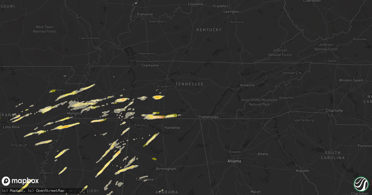
Hail Map in Tennessee on March 31, 2016
Get this storm
March 31 map
$229
one time, instant access
Download today. No call, no setup
Keep the $229
Bought the map and want the full workflow? Apply the entire $229 to a subscription within 7 days. None of it is wasted.
Every map, not just this one
This buys you this map. Subscription and you get every map we run, in the markets you choose from a few cities to whole states to nationwide. Plus real-time alerts the moment a storm fires.
Contact data
Name, contact info, occupancy, even credit band for addresses in the footprint. You go from where it hit to who to call.
Become the source they trust
Unlimited branding weather history reports on demand. You already have the documented answer ready for the property owner, and you are the one who showed up with it.
Property data and RoofTrace estimates
Pull up any address you have got, its value and the exact code rules for that jurisdiction, straight from One Click Code. Then RoofTrace estimates the squares, pitch, and roof value, priced the way you price.
Storm reports in Tennessee
Tennessee
| Date | Description |
|---|---|
| 03/31/20166:57 PM CDT | A local report indicates 1.00 inch wind near SMITHVILLE |
| 03/31/20166:30 PM CDT | Tree on home along north cove dr in murfreesboro |
| 03/31/20166:30 PM CDT | Trees blocking blooming grove road and appleton road |
| 03/31/20166:15 PM CDT | An nws storm survey team determined that 70mph straight line winds caused minor tree damage along shannon creek road in southwest giles county. |
| 03/31/20165:54 PM CDT | Trees down across southeastern portions of county |
| 03/31/20165:46 PM CDT | 50 to 60 mph windgust estimation |
| 03/31/20165:37 PM CDT | Golfball hail just west of columbia |
| 03/31/20165:34 PM CDT | Several trees down on hidden lake circle in columbia |
| 03/31/20165:33 PM CDT | 15 to 20 trees down |
| 03/31/20165:18 PM CDT | An nws storm survey team determined that straight line winds were the cause for damage in western maury county. An old barn was destroyed along cecil farm road along wi |
| 03/31/20165:12 PM CDT | 12 inch diameter tree down south of collinwood |
| 03/31/20164:58 PM CDT | Many trees down and one house destoryed near pickwick dam. This is possible tornado. |
| 03/31/20164:57 PM CDT | Fallen tree crushed a barn along betts road at smith road |
| 03/31/20164:50 PM CDT | Trees and powerlines down along hwy 48n and forrest ave |
| 03/31/20164:50 PM CDT | Trained spotter estimates 60 to 70 mph tstm wind gust in pleasant view |
| 03/31/20164:45 PM CDT | An nws storm survey team found ef0 anticyclonic tornado damage in northwest lewis county. A few trees were uprooted and snapped along darbytown road with several large |
| 03/31/20164:32 PM CDT | An nws storm survey team found damage in southeast perry county from an ef1 tornado. The tornado uprooted...snapped or downed hundreds of trees along its path before en |
| 03/31/20164:28 PM CDT | An ef-1 tornado caused damage to a house and rv just east of the tennessee river. |
| 03/31/20164:25 PM CDT | Quarter size hail in savannah. |
| 03/31/20164:24 PM CDT | Some trees down across central portions of the county |
| 03/31/20163:33 PM CDT | Sturctural damage and trees down in the roby community. Along with pea size hail. |
| 03/31/20163:29 PM CDT | Golf ball sized hail in reagan... Tennessee |
| 03/31/20163:20 PM CDT | 50 mph winds with quarter sized hail east of henderson. |
| 03/31/20162:54 PM CDT | Quarter sized hail in downtown jackson |
| 03/31/20162:48 PM CDT | An estimated wind gust of 60 mph in downtown jackson. |
| 03/31/20161:16 PM CDT | Gas station tenant reports quarter sized hail. |
| 03/31/20161:16 PM CDT | Trees down along mudville road. |
| 03/31/20161:15 PM CDT | Power poles blown over in atoka. |
| 03/31/20161:05 PM CDT | Power lines knocked down in drummonds. |
| 03/31/201612:53 PM CDT | Quarter size hail in halls. |
| 03/31/201612:00 PM CDT | Semi-truck blown over on i-55 south of burdette. |
| 03/30/20167:43 PM CDT | Quarter size hail was reported. |
| 03/30/20167:42 PM CDT | Trees down across sc/se portions of county |
All States Impacted by Hail Map on March 31, 2016
Cities Impacted by Hail Map on March 31, 2016
- Wellington, IL
- Milford, IL
- Zwingle, IA
- Bernard, IA
- La Motte, IA
- Heber Springs, AR
- Natchitoches, LA
- Fredericksburg, TX
- Comfort, TX
- Brownsville, TN
- Brandon, MS
- Mendenhall, MS
- Morton, MS
- Florence, MS
- Raleigh, MS
- Braxton, MS
- Donalsonville, GA
- Columbia, TN
- Mount Pleasant, TN
- Patoka, IN
- Pulaski, MS
- Provencal, LA
- Elora, TN
- Flintville, TN
- Huntland, TN
- Union, MS
- Little Rock, MS
- Vernon, IL
- Alma, IL
- Patoka, IL
- Kinmundy, IL
- Leakey, TX
- McRae, AR
- Griffithville, AR
- Searcy, AR
- Sherwood, AR
- Little Rock Air Force Base, AR
- Beebe, AR
- Ward, AR
- Cabot, AR
- Jacksonville, AR
- North Little Rock, AR
- Austin, AR
- Hermanville, MS
- Vicksburg, MS
- Utica, MS
- Port Gibson, MS
- Drummonds, TN
- Millington, TN
- Samson, AL
- Coffee Springs, AL
- Geneva, AL
- Madison, MS
- Lamar, MS
- Bentley, LA
- Dry Prong, LA
- Pollock, LA
- Gordon, AL
- Scotts Hill, TN
- Huron, TN
- Reagan, TN
- Lexington, TN
- Magee, MS
- Hernando, MS
- Marianna, AR
- Moro, AR
- Brackettville, TX
- Northport, AL
- Buhl, AL
- Tuscaloosa, AL
- Coker, AL
- Crystal City, TX
- Butler, GA
- Reynolds, GA
- Montgomery, AL
- Forest, MS
- Lake, MS
- Coushatta, LA
- Cedarbluff, MS
- Osceola, AR
- Tutwiler, MS
- Mound Bayou, MS
- Drew, MS
- Ingraham, IL
- Clay City, IL
- Yazoo City, MS
- Benton, MS
- Olla, LA
- Amory, MS
- Robeline, LA
- Natchez, LA
- Sweeny, TX
- Van Vleck, TX
- Ruston, LA
- Choudrant, LA
- Michigan City, MS
- Ashland, MS
- Tallassee, AL
- Shorter, AL
- Millbrook, AL
- Prattville, AL
- Wetumpka, AL
- Coosada, AL
- Elmore, AL
- Tuskegee, AL
- Pike Road, AL
- Eclectic, AL
- Winnsboro, LA
- Delhi, LA
- Uvalde, TX
- Westpoint, TN
- Iron City, TN
- Bethel Springs, TN
- Adamsville, TN
- Selmer, TN
- Saline, LA
- Mansfield, LA
- Pelican, LA
- Prairie, MS
- Halls, TN
- Ripley, TN
- Minor Hill, TN
- Five Points, TN
- Marion, AR
- Dennis, MS
- Tishomingo, MS
- Iuka, MS
- Clarksdale, MS
- Monticello, MS
- Silver Creek, MS
- Batesville, TX
- La Pryor, TX
- Coffeeville, AL
- Toxey, AL
- Gilbertown, AL
- Sallis, MS
- Camden, MS
- Kosciusko, MS
- McIntosh, AL
- Deer Park, AL
- Citronelle, AL
- Middleton, TN
- Nettleton, MS
- Nashville, IL
- Ward, AL
- Pennington, AL
- Toone, TN
- Whiteville, TN
- Satartia, MS
- Moorhead, MS
- Somerville, TN
- Inverness, MS
- Itta Bena, MS
- Schlater, MS
- Lolita, TX
- Canton, MS
- Decatur, MS
- Conehatta, MS
- Louisville, MS
- Vinegar Bend, AL
- Moulton, AL
- Haleyville, AL
- Danville, AL
- Kennedy, AL
- Millport, AL
- Ethelsville, AL
- Edwards, MS
- De Witt, AR
- Elaine, AR
- Ethel, AR
- Saint Charles, AR
- Clinton, IA
- Camanche, IA
- Bentonia, MS
- Vance, MS
- Lambert, MS
- Merigold, MS
- Redwood, MS
- Vernon, AL
- Sulligent, AL
- Guin, AL
- Steens, MS
- Fayette, AL
- Winfield, AL
- Bloomington, IN
- Ellettsville, IN
- Munford, TN
- Aberdeen, MS
- Sikes, LA
- Dodson, LA
- Philadelphia, MS
- Collinsville, MS
- Burnsville, MS
- Goldonna, LA
- Jonesboro, LA
- Castor, LA
- Many, LA
- Montgomery, LA
- Stanton, TN
- Wisner, LA
- Tullos, LA
- Fort Necessity, LA
- Georgetown, LA
- Harrisonburg, LA
- Kelly, LA
- Columbia, LA
- Gilbert, LA
- Enterprise, LA
- Winnfield, LA
- Brewton, AL
- Castleberry, AL
- Ardmore, TN
- Fayetteville, TN
- Taft, TN
- Ringgold, LA
- Humnoke, AR
- Stuttgart, AR
- Sardis, AL
- Minter, AL
- Union Grove, WI
- Sturtevant, WI
- Kenosha, WI
- Jakin, GA
- Iron City, GA
- Colquitt, GA
- Brinson, GA
- Medina, TX
- Shiloh, TN
- Michie, TN
- Stantonville, TN
- Morris Chapel, TN
- Savannah, TN
- Wheatfield, IN
- Hebron, IN
- Linton, IN
- Jasonville, IN
- Lena, LA
- Colfax, LA
- Mora, LA
- Holly Grove, AR
- Floresville, TX
- Adkins, TX
- Elmendorf, TX
- La Vernia, TX
- San Antonio, TX
- Keiser, AR
- Mooreville, MS
- Verona, MS
- Tupelo, MS
- Newhebron, MS
- Prentiss, MS
- Glen, MS
- McCrory, AR
- Wynne, AR
- Marion, AL
- Plantersville, AL
- Campti, LA
- Pelahatchie, MS
- Smithville, MS
- Okolona, MS
- Houlka, MS
- Caraway, AR
- Luxora, AR
- Lepanto, AR
- Etowah, AR
- Harrisburg, AR
- Marked Tree, AR
- Trumann, AR
- Fort Valley, GA
- Roberta, GA
- Luray, TN
- Jacks Creek, TN
- Lexington, AL
- Loretto, TN
- Leoma, TN
- Prospect, TN
- Lester, AL
- Anderson, AL
- Goodspring, TN
- Hickory Ridge, AR
- Augusta, AR
- Brighton, TN
- Bastrop, LA
- Eros, LA
- Chatham, LA
- Calhoun, LA
- Quitman, LA
- Mason, TN
- Bolton, MS
- Memphis, TN
- Lake Cormorant, MS
- Forrest City, AR
- Hughes, AR
- Arlington, TN
- Cordova, TN
- Oakland, TN
- Eads, TN
- Red Bay, AL
- Tremont, MS
- Golden, MS
- Devine, TX
- Moore, TX
- Bigfoot, TX
- Lytle, TX
- Poteet, TX
- Somerset, TX
- Natalia, TX
- Valparaiso, IN
- McKenzie, AL
- Hickory, MS
- Hamburg, AR
- Portland, AR
- Parkdale, AR
- Princeton, IA
- Spencer, IN
- Gosport, IN
- Von Ormy, TX
- Andalusia, AL
- Lena, MS
- Hall Summit, LA
- Decaturville, TN
- Sardis, TN
- Henderson, TN
- Conway, AR
- Vilonia, AR
- Uniontown, AL
- Newbern, AL
- Faunsdale, AL
- Randolph, AL
- Lawley, AL
- De Kalb, MS
- Thomaston, AL
- Barksdale, TX
- Baskin, LA
- Rayville, LA
- Mangham, LA
- Grayson, LA
- Monroe, LA
- Louin, MS
- Clarendon, AR
- Roe, AR
- Marthaville, LA
- Sullivan, IN
- Worthington, IN
- Fulton, MS
- Chesterton, IN
- Cherry Valley, AR
- Chancellor, AL
- Blakely, GA
- Holly Springs, MS
- Walnut, MS
- Falkner, MS
- Clopton, AL
- Skipperville, AL
- Ariton, AL
- Clio, AL
- Newellton, LA
- Collins, MS
- Eupora, MS
- Saltillo, MS
- Shannon, MS
- Plantersville, MS
- Houston, MS
- Mantee, MS
- Mantachie, MS
- Calhoun City, MS
- Woodland, MS
- Center Point, TX
- Macon, MS
- West Monroe, LA
- Florala, AL
- Covington, TN
- Atoka, TN
- Turrell, AR
- Evergreen, AL
- Camp Wood, TX
- Dickinson, TX
- La Marque, TX
- Rosharon, TX
- Liverpool, TX
- Alvin, TX
- Santa Fe, TX
- Manteno, IL
- Edinburgh, IN
- Shelbyville, IN
- Franklin, IN
- Columbus, MS
- Oxford, MS
- Abbeville, MS
- Dugger, IN
- Lexa, AR
- Brickeys, AR
- Robinsonville, MS
- Tunica, MS
- Little River, AL
- Uriah, AL
- New Albany, MS
- Flora, MS
- Hampshire, TN
- Tallulah, LA
- Opp, AL
- Carlyle, IL
- Sandoval, IL
- Vandalia, IL
- Carlisle, AR
- Wabbaseka, AR
- Hohenwald, TN
- Hobart, IN
- Westville, IN
- Michigan City, IN
- Rocksprings, TX
- Gillett, AR
- Almyra, AR
- Pearsall, TX
- Ackerman, MS
- Flatwoods, LA
- Ingram, TX
- Lutts, TN
- Counce, TN
- Waterloo, AL
- Collinwood, TN
- Sicily Island, LA
- Aimwell, LA
- Atlanta, LA
- Jena, LA
- Cloutierville, LA
- Double Springs, AL
- Valley Park, MS
- Terry, MS
- Raymond, MS
- Yuma, TN
- Leesville, LA
- Myrtle, MS
- Rose Bud, AR
- Greensboro, AL
- Linden, AL
- Sweet Water, AL
- Dyersburg, TN
- Saint Joseph, LA
- Clinton, MS
- Daleville, AL
- Kinston, AL
- Black, AL
- Hartford, AL
- Tilden, TX
- Bainbridge, GA
- Linden, TN
- Pinson, TN
- Cottondale, AL
- Quitman, AR
- Mount Vernon, AR
- Kerrville, TX
- Tyronza, AR
- Bailey, MS
- Meridian, MS
- Daleville, MS
- Caledonia, MS
- Gattman, MS
- Hamilton, MS
- Mathiston, MS
- Maben, MS
- Sturgis, MS
- Mercer, TN
- Bassett, AR
- Joiner, AR
- Gilmore, AR
- Crawfordsville, AR
- Denmark, TN
- Frenchmans Bayou, AR
- Pleasant Hill, LA
- Thomasville, AL
- Campbell, AL
- Medon, TN
- Jackson, MS
- Ridgeland, MS
- Shobonier, IL
- Bald Knob, AR
- Florence, AL
- Elkmont, AL
- Saint Joseph, TN
- Killen, AL
- Pulaski, TN
- Flora, IL
- Olivehill, TN
- Waynesboro, TN
- Clifton, TN
- Bath Springs, TN
- Kingsford Heights, IN
- Union Mills, IN
- Pearl, MS
- Byram, MS
- Richland, MS
- Flowood, MS
- Crawford, MS
- Weir, MS
- Orrville, AL
- Spruce Pine, AL
- Marvell, AR
- Oak Ridge, LA
- Casscoe, AR
- Ramer, TN
- Guys, TN
- Racine, WI
- Rienzi, MS
- Starkville, MS
- Pheba, MS
- West Point, MS
- New Site, MS
- Cherokee, AL
- Grand Junction, TN
- Corinth, MS
- Concan, TX
- Texas City, TX
- Phil Campbell, AL
- Del Rio, TX
- Cordova, IL
- Newton, MS
- Tuscola, IL
- Enville, TN
- Carson, MS
- Cottonwood, AL
- Ashford, AL
- Dothan, AL
- Hodges, AL
- Friendship, TN
- Hickory Valley, TN
- Saulsbury, TN
- Bolivar, TN
- Hornsby, TN
- Gleason, TN
- Cleveland, MS
- Fisher, LA
- Converse, LA
- Georgiana, AL
- Greenville, AL
- Midfield, TX
- Blessing, TX
- Hitchcock, TX
- Judsonia, AR
- Lowell, IN
- Centreville, AL
- Beverly Shores, IN
- Cash, AR
- Jonesboro, AR
- Nineveh, IN
- Flat Rock, IN
- Trout, LA
- Taylorsville, MS
- Beech Bluff, TN
- Hunt, TX
- Crump, TN
- De Valls Bluff, AR
- Pontotoc, MS
- Gallion, AL
- Schneider, IN
- Marmaduke, AR
- Lawrence, MS
- Bay Springs, MS
- Walnut Grove, MS
- Crystal Springs, MS
- Stockton, AL
- Jackson, AL
- Atmore, AL
- Carthage, MS
- York, AL
- Dixons Mills, AL
- Kelso, TN
- Owensville, IN
- Griffin, IN
- Town Creek, AL
- Russell, AR
- Princeton, IN
- Magnolia, AL
- Pine Hill, AL
- Jackson, TN
- Perryville, AR
- Trinity, AL
- Decatur, AL
- Carlisle, IN
- Noxapater, MS
- Preston, MS
- Shuqualak, MS
- Aliceville, AL
- Thomson, IL
- Chadwick, IL
- Earle, AR
- Pansey, AL
- Brinkley, AR
- Needham, AL
- Mize, MS
- Sebastopol, MS
- Portage, IN
- Santa Fe, TN
- Salem, WI
- Silver Lake, WI
- Burlington, WI
- Twin Lakes, WI
- Fulton, IL
- Bigelow, AR
- Houston, AR
- Marion, LA
- Nesbit, MS
- Lawrenceburg, TN
- Heidelberg, MS
- Laurel, MS
- Jasper, AL
- Cordova, AL
- Unionville, IN


