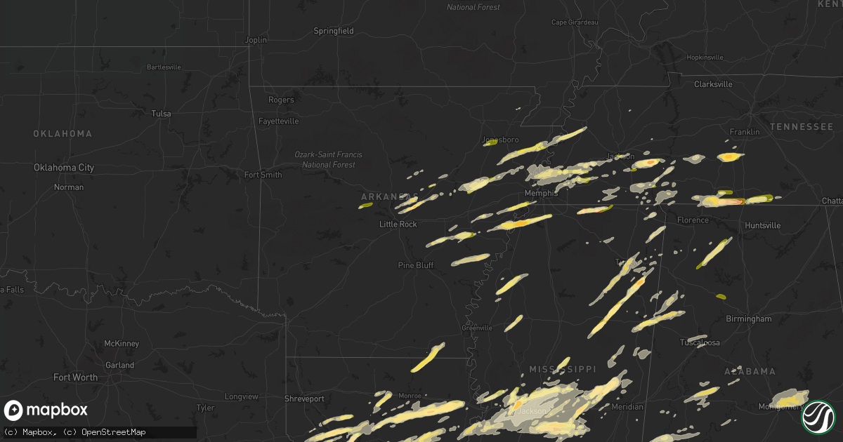
Hail Map in Arkansas on March 31, 2016
Get this storm
March 31 map
$229
one time, instant access
Download today. No call, no setup
Keep the $229
Bought the map and want the full workflow? Apply the entire $229 to a subscription within 7 days. None of it is wasted.
Every map, not just this one
This buys you this map. Subscription and you get every map we run, in the markets you choose from a few cities to whole states to nationwide. Plus real-time alerts the moment a storm fires.
Contact data
Name, contact info, occupancy, even credit band for addresses in the footprint. You go from where it hit to who to call.
Become the source they trust
Unlimited branding weather history reports on demand. You already have the documented answer ready for the property owner, and you are the one who showed up with it.
Property data and RoofTrace estimates
Pull up any address you have got, its value and the exact code rules for that jurisdiction, straight from One Click Code. Then RoofTrace estimates the squares, pitch, and roof value, priced the way you price.
Storm reports in Arkansas
Arkansas
| Date | Description |
|---|---|
| 03/31/20163:33 PM CDT | Hail fell...ranging from the size of marbles to quarters. |
| 03/31/201612:51 PM CDT | Home weather station anemometer recorded a gust of 80 mph. |
| 03/31/201612:51 PM CDT | Shutter blown off of home from the estimated 80 mph gust. |
| 03/31/201612:05 PM CDT | Dozens of trees and power poles down...mostly on the north side of town. |
| 03/31/201612:00 PM CDT | Semi-truck blown over on i-55 south of burdette. |
| 03/31/201612:00 PM CDT | 1 inch hail in lepanto. |
| 03/31/201611:00 AM CDT | Ping pong ball size hail reported through social media. |
| 03/31/201610:40 AM CDT | High winds took large chunks of siding off a downtown jonesboro building. |
| 03/31/201610:32 AM CDT | 1 inch hail in west jonesboro. |
| 03/31/20169:38 AM CDT | Penny to quarter size hail in searcy. |
| 03/31/20168:42 AM CDT | Quarter size hail in perryville. |
All States Impacted by Hail Map on March 31, 2016
Cities Impacted by Hail Map on March 31, 2016
- Wellington, IL
- Milford, IL
- Zwingle, IA
- Bernard, IA
- La Motte, IA
- Heber Springs, AR
- Natchitoches, LA
- Fredericksburg, TX
- Comfort, TX
- Brownsville, TN
- Brandon, MS
- Mendenhall, MS
- Morton, MS
- Florence, MS
- Raleigh, MS
- Braxton, MS
- Donalsonville, GA
- Columbia, TN
- Mount Pleasant, TN
- Patoka, IN
- Pulaski, MS
- Provencal, LA
- Elora, TN
- Flintville, TN
- Huntland, TN
- Union, MS
- Little Rock, MS
- Vernon, IL
- Alma, IL
- Patoka, IL
- Kinmundy, IL
- Leakey, TX
- McRae, AR
- Griffithville, AR
- Searcy, AR
- Sherwood, AR
- Little Rock Air Force Base, AR
- Beebe, AR
- Ward, AR
- Cabot, AR
- Jacksonville, AR
- North Little Rock, AR
- Austin, AR
- Hermanville, MS
- Vicksburg, MS
- Utica, MS
- Port Gibson, MS
- Drummonds, TN
- Millington, TN
- Samson, AL
- Coffee Springs, AL
- Geneva, AL
- Madison, MS
- Lamar, MS
- Bentley, LA
- Dry Prong, LA
- Pollock, LA
- Gordon, AL
- Scotts Hill, TN
- Huron, TN
- Reagan, TN
- Lexington, TN
- Magee, MS
- Hernando, MS
- Marianna, AR
- Moro, AR
- Brackettville, TX
- Northport, AL
- Buhl, AL
- Tuscaloosa, AL
- Coker, AL
- Crystal City, TX
- Butler, GA
- Reynolds, GA
- Montgomery, AL
- Forest, MS
- Lake, MS
- Coushatta, LA
- Cedarbluff, MS
- Osceola, AR
- Tutwiler, MS
- Mound Bayou, MS
- Drew, MS
- Ingraham, IL
- Clay City, IL
- Yazoo City, MS
- Benton, MS
- Olla, LA
- Amory, MS
- Robeline, LA
- Natchez, LA
- Sweeny, TX
- Van Vleck, TX
- Ruston, LA
- Choudrant, LA
- Michigan City, MS
- Ashland, MS
- Tallassee, AL
- Shorter, AL
- Millbrook, AL
- Prattville, AL
- Wetumpka, AL
- Coosada, AL
- Elmore, AL
- Tuskegee, AL
- Pike Road, AL
- Eclectic, AL
- Winnsboro, LA
- Delhi, LA
- Uvalde, TX
- Westpoint, TN
- Iron City, TN
- Bethel Springs, TN
- Adamsville, TN
- Selmer, TN
- Saline, LA
- Mansfield, LA
- Pelican, LA
- Prairie, MS
- Halls, TN
- Ripley, TN
- Minor Hill, TN
- Five Points, TN
- Marion, AR
- Dennis, MS
- Tishomingo, MS
- Iuka, MS
- Clarksdale, MS
- Monticello, MS
- Silver Creek, MS
- Batesville, TX
- La Pryor, TX
- Coffeeville, AL
- Toxey, AL
- Gilbertown, AL
- Sallis, MS
- Camden, MS
- Kosciusko, MS
- McIntosh, AL
- Deer Park, AL
- Citronelle, AL
- Middleton, TN
- Nettleton, MS
- Nashville, IL
- Ward, AL
- Pennington, AL
- Toone, TN
- Whiteville, TN
- Satartia, MS
- Moorhead, MS
- Somerville, TN
- Inverness, MS
- Itta Bena, MS
- Schlater, MS
- Lolita, TX
- Canton, MS
- Decatur, MS
- Conehatta, MS
- Louisville, MS
- Vinegar Bend, AL
- Moulton, AL
- Haleyville, AL
- Danville, AL
- Kennedy, AL
- Millport, AL
- Ethelsville, AL
- Edwards, MS
- De Witt, AR
- Elaine, AR
- Ethel, AR
- Saint Charles, AR
- Clinton, IA
- Camanche, IA
- Bentonia, MS
- Vance, MS
- Lambert, MS
- Merigold, MS
- Redwood, MS
- Vernon, AL
- Sulligent, AL
- Guin, AL
- Steens, MS
- Fayette, AL
- Winfield, AL
- Bloomington, IN
- Ellettsville, IN
- Munford, TN
- Aberdeen, MS
- Sikes, LA
- Dodson, LA
- Philadelphia, MS
- Collinsville, MS
- Burnsville, MS
- Goldonna, LA
- Jonesboro, LA
- Castor, LA
- Many, LA
- Montgomery, LA
- Stanton, TN
- Wisner, LA
- Tullos, LA
- Fort Necessity, LA
- Georgetown, LA
- Harrisonburg, LA
- Kelly, LA
- Columbia, LA
- Gilbert, LA
- Enterprise, LA
- Winnfield, LA
- Brewton, AL
- Castleberry, AL
- Ardmore, TN
- Fayetteville, TN
- Taft, TN
- Ringgold, LA
- Humnoke, AR
- Stuttgart, AR
- Sardis, AL
- Minter, AL
- Union Grove, WI
- Sturtevant, WI
- Kenosha, WI
- Jakin, GA
- Iron City, GA
- Colquitt, GA
- Brinson, GA
- Medina, TX
- Shiloh, TN
- Michie, TN
- Stantonville, TN
- Morris Chapel, TN
- Savannah, TN
- Wheatfield, IN
- Hebron, IN
- Linton, IN
- Jasonville, IN
- Lena, LA
- Colfax, LA
- Mora, LA
- Holly Grove, AR
- Floresville, TX
- Adkins, TX
- Elmendorf, TX
- La Vernia, TX
- San Antonio, TX
- Keiser, AR
- Mooreville, MS
- Verona, MS
- Tupelo, MS
- Newhebron, MS
- Prentiss, MS
- Glen, MS
- McCrory, AR
- Wynne, AR
- Marion, AL
- Plantersville, AL
- Campti, LA
- Pelahatchie, MS
- Smithville, MS
- Okolona, MS
- Houlka, MS
- Caraway, AR
- Luxora, AR
- Lepanto, AR
- Etowah, AR
- Harrisburg, AR
- Marked Tree, AR
- Trumann, AR
- Fort Valley, GA
- Roberta, GA
- Luray, TN
- Jacks Creek, TN
- Lexington, AL
- Loretto, TN
- Leoma, TN
- Prospect, TN
- Lester, AL
- Anderson, AL
- Goodspring, TN
- Hickory Ridge, AR
- Augusta, AR
- Brighton, TN
- Bastrop, LA
- Eros, LA
- Chatham, LA
- Calhoun, LA
- Quitman, LA
- Mason, TN
- Bolton, MS
- Memphis, TN
- Lake Cormorant, MS
- Forrest City, AR
- Hughes, AR
- Arlington, TN
- Cordova, TN
- Oakland, TN
- Eads, TN
- Red Bay, AL
- Tremont, MS
- Golden, MS
- Devine, TX
- Moore, TX
- Bigfoot, TX
- Lytle, TX
- Poteet, TX
- Somerset, TX
- Natalia, TX
- Valparaiso, IN
- McKenzie, AL
- Hickory, MS
- Hamburg, AR
- Portland, AR
- Parkdale, AR
- Princeton, IA
- Spencer, IN
- Gosport, IN
- Von Ormy, TX
- Andalusia, AL
- Lena, MS
- Hall Summit, LA
- Decaturville, TN
- Sardis, TN
- Henderson, TN
- Conway, AR
- Vilonia, AR
- Uniontown, AL
- Newbern, AL
- Faunsdale, AL
- Randolph, AL
- Lawley, AL
- De Kalb, MS
- Thomaston, AL
- Barksdale, TX
- Baskin, LA
- Rayville, LA
- Mangham, LA
- Grayson, LA
- Monroe, LA
- Louin, MS
- Clarendon, AR
- Roe, AR
- Marthaville, LA
- Sullivan, IN
- Worthington, IN
- Fulton, MS
- Chesterton, IN
- Cherry Valley, AR
- Chancellor, AL
- Blakely, GA
- Holly Springs, MS
- Walnut, MS
- Falkner, MS
- Clopton, AL
- Skipperville, AL
- Ariton, AL
- Clio, AL
- Newellton, LA
- Collins, MS
- Eupora, MS
- Saltillo, MS
- Shannon, MS
- Plantersville, MS
- Houston, MS
- Mantee, MS
- Mantachie, MS
- Calhoun City, MS
- Woodland, MS
- Center Point, TX
- Macon, MS
- West Monroe, LA
- Florala, AL
- Covington, TN
- Atoka, TN
- Turrell, AR
- Evergreen, AL
- Camp Wood, TX
- Dickinson, TX
- La Marque, TX
- Rosharon, TX
- Liverpool, TX
- Alvin, TX
- Santa Fe, TX
- Manteno, IL
- Edinburgh, IN
- Shelbyville, IN
- Franklin, IN
- Columbus, MS
- Oxford, MS
- Abbeville, MS
- Dugger, IN
- Lexa, AR
- Brickeys, AR
- Robinsonville, MS
- Tunica, MS
- Little River, AL
- Uriah, AL
- New Albany, MS
- Flora, MS
- Hampshire, TN
- Tallulah, LA
- Opp, AL
- Carlyle, IL
- Sandoval, IL
- Vandalia, IL
- Carlisle, AR
- Wabbaseka, AR
- Hohenwald, TN
- Hobart, IN
- Westville, IN
- Michigan City, IN
- Rocksprings, TX
- Gillett, AR
- Almyra, AR
- Pearsall, TX
- Ackerman, MS
- Flatwoods, LA
- Ingram, TX
- Lutts, TN
- Counce, TN
- Waterloo, AL
- Collinwood, TN
- Sicily Island, LA
- Aimwell, LA
- Atlanta, LA
- Jena, LA
- Cloutierville, LA
- Double Springs, AL
- Valley Park, MS
- Terry, MS
- Raymond, MS
- Yuma, TN
- Leesville, LA
- Myrtle, MS
- Rose Bud, AR
- Greensboro, AL
- Linden, AL
- Sweet Water, AL
- Dyersburg, TN
- Saint Joseph, LA
- Clinton, MS
- Daleville, AL
- Kinston, AL
- Black, AL
- Hartford, AL
- Tilden, TX
- Bainbridge, GA
- Linden, TN
- Pinson, TN
- Cottondale, AL
- Quitman, AR
- Mount Vernon, AR
- Kerrville, TX
- Tyronza, AR
- Bailey, MS
- Meridian, MS
- Daleville, MS
- Caledonia, MS
- Gattman, MS
- Hamilton, MS
- Mathiston, MS
- Maben, MS
- Sturgis, MS
- Mercer, TN
- Bassett, AR
- Joiner, AR
- Gilmore, AR
- Crawfordsville, AR
- Denmark, TN
- Frenchmans Bayou, AR
- Pleasant Hill, LA
- Thomasville, AL
- Campbell, AL
- Medon, TN
- Jackson, MS
- Ridgeland, MS
- Shobonier, IL
- Bald Knob, AR
- Florence, AL
- Elkmont, AL
- Saint Joseph, TN
- Killen, AL
- Pulaski, TN
- Flora, IL
- Olivehill, TN
- Waynesboro, TN
- Clifton, TN
- Bath Springs, TN
- Kingsford Heights, IN
- Union Mills, IN
- Pearl, MS
- Byram, MS
- Richland, MS
- Flowood, MS
- Crawford, MS
- Weir, MS
- Orrville, AL
- Spruce Pine, AL
- Marvell, AR
- Oak Ridge, LA
- Casscoe, AR
- Ramer, TN
- Guys, TN
- Racine, WI
- Rienzi, MS
- Starkville, MS
- Pheba, MS
- West Point, MS
- New Site, MS
- Cherokee, AL
- Grand Junction, TN
- Corinth, MS
- Concan, TX
- Texas City, TX
- Phil Campbell, AL
- Del Rio, TX
- Cordova, IL
- Newton, MS
- Tuscola, IL
- Enville, TN
- Carson, MS
- Cottonwood, AL
- Ashford, AL
- Dothan, AL
- Hodges, AL
- Friendship, TN
- Hickory Valley, TN
- Saulsbury, TN
- Bolivar, TN
- Hornsby, TN
- Gleason, TN
- Cleveland, MS
- Fisher, LA
- Converse, LA
- Georgiana, AL
- Greenville, AL
- Midfield, TX
- Blessing, TX
- Hitchcock, TX
- Judsonia, AR
- Lowell, IN
- Centreville, AL
- Beverly Shores, IN
- Cash, AR
- Jonesboro, AR
- Nineveh, IN
- Flat Rock, IN
- Trout, LA
- Taylorsville, MS
- Beech Bluff, TN
- Hunt, TX
- Crump, TN
- De Valls Bluff, AR
- Pontotoc, MS
- Gallion, AL
- Schneider, IN
- Marmaduke, AR
- Lawrence, MS
- Bay Springs, MS
- Walnut Grove, MS
- Crystal Springs, MS
- Stockton, AL
- Jackson, AL
- Atmore, AL
- Carthage, MS
- York, AL
- Dixons Mills, AL
- Kelso, TN
- Owensville, IN
- Griffin, IN
- Town Creek, AL
- Russell, AR
- Princeton, IN
- Magnolia, AL
- Pine Hill, AL
- Jackson, TN
- Perryville, AR
- Trinity, AL
- Decatur, AL
- Carlisle, IN
- Noxapater, MS
- Preston, MS
- Shuqualak, MS
- Aliceville, AL
- Thomson, IL
- Chadwick, IL
- Earle, AR
- Pansey, AL
- Brinkley, AR
- Needham, AL
- Mize, MS
- Sebastopol, MS
- Portage, IN
- Santa Fe, TN
- Salem, WI
- Silver Lake, WI
- Burlington, WI
- Twin Lakes, WI
- Fulton, IL
- Bigelow, AR
- Houston, AR
- Marion, LA
- Nesbit, MS
- Lawrenceburg, TN
- Heidelberg, MS
- Laurel, MS
- Jasper, AL
- Cordova, AL
- Unionville, IN


