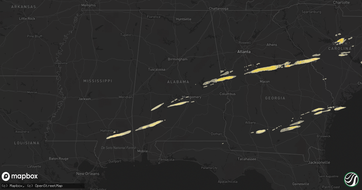
Hail Map in Alabama on February 24, 2012
Get this storm
February 24 map
$229
one time, instant access
Download today. No call, no setup
Keep the $229
Bought the map and want the full workflow? Apply the entire $229 to a subscription within 7 days. None of it is wasted.
Every map, not just this one
This buys you this map. Subscription and you get every map we run, in the markets you choose from a few cities to whole states to nationwide. Plus real-time alerts the moment a storm fires.
Contact data
Name, contact info, occupancy, even credit band for addresses in the footprint. You go from where it hit to who to call.
Become the source they trust
Unlimited branding weather history reports on demand. You already have the documented answer ready for the property owner, and you are the one who showed up with it.
Property data and RoofTrace estimates
Pull up any address you have got, its value and the exact code rules for that jurisdiction, straight from One Click Code. Then RoofTrace estimates the squares, pitch, and roof value, priced the way you price.
Storm reports in Alabama
Alabama
| Date | Description |
|---|---|
| 02/24/201212:01 PM CST | A few trees were blown down near eufaula. Winds were estimated around 50 mph. |
| 02/24/201211:30 AM CST | A few trees were blown down in northern barbour county near comer. Winds were estimated around 50 mph. |
| 02/24/201210:56 AM CST | Emergency manager reported a horse shed that was blown over and destroyed along n. Goshen road. |
| 02/24/201210:43 AM CST | A few trees were blown down in far southern montgomery county near highway 231. Winds were estimated around 50 mph. |
| 02/24/201210:26 AM CST | Tree down along mill pond road. Crews dispatched to clear roadway. Winds est at 40kts. |
| 02/24/201210:24 AM CST | Quarter size hail reported along county road 33. |
| 02/24/201210:24 AM CST | Several trees were blown down near interstate 65. |
| 02/24/201210:05 AM CST | Numerous trees reported down along i-65 near greenville |
| 02/24/20129:50 AM CST | Moth ball to quarter size hail was reported near the wilcox and dallas county line. Some of the hail was covering the ground. |
| 02/24/20129:43 AM CST | Several trees were blown down near interstate 65. |
| 02/24/20129:40 AM CST | Large branches and a tree knocked down between wetumpka and eclectic. Winds estimated around 45 mph. |
| 02/24/20129:30 AM CST | A tree was blown down on redland road and blocked the roadway. The winds were estimated around 40 mph. |
| 02/24/20129:26 AM CST | A tree was blown down near holtville and blocked the roadway. Winds were estiamted around 40 mph. |
| 02/24/20129:25 AM CST | A local report indicates 1.00 inch wind near HAYNEVILLE |
| 02/24/20129:17 AM CST | Tree damage reported on bridalwood path roughly a half mile northeast of where harper head start school was damaged. |
| 02/24/20129:15 AM CST | Harper headstart school sustained roof damage. |
| 02/24/20129:11 AM CST | A tree was blown down on bond road near deatsville and it blocked the roadway. Winds were estimated around 40 mph. |
| 02/24/20127:50 AM CST | Several pine trees were snapped and one utility building was overturned in the city of lanett. |
| 02/24/20126:49 AM CST | A tree fell into the roadway and a vehicle ran into it. Winds were estimated around 45 mph. |
All States Impacted by Hail Map on February 24, 2012
Cities Impacted by Hail Map on February 24, 2012
- Aiken, SC
- Warrenville, SC
- North Augusta, SC
- Augusta, GA
- Grovetown, GA
- Graniteville, SC
- Beech Island, SC
- Gloverville, SC
- Montgomery, AL
- Quinton, VA
- Sandston, VA
- Midlothian, VA
- Henrico, VA
- Richmond, VA
- Chesterfield, VA
- Mechanicsville, VA
- Harlem, GA
- Equality, AL
- Pine Mountain, GA
- Lagrange, GA
- West Point, GA
- Alma, GA
- Nicholls, GA
- Douglas, GA
- Axson, GA
- Millwood, GA
- Richlands, NC
- Rose Hill, NC
- Trenton, NC
- Pink Hill, NC
- Kenansville, NC
- Beulaville, NC
- Magnolia, NC
- Sparta, GA
- Columbia, SC
- Elgin, SC
- Hopkins, SC
- Camden, AL
- Pine Hill, AL
- Thomasville, AL
- Arlington, AL
- Catherine, AL
- Lenox, GA
- Enigma, GA
- Hephzibah, GA
- Thomson, GA
- Dearing, GA
- Mitchell, GA
- Warrenton, GA
- Jewell, GA
- Eatonton, GA
- Tobaccoville, NC
- Chester, VA
- Hayneville, AL
- Wingate, MD
- Vienna, MD
- Toddville, MD
- Crapo, MD
- Lugoff, SC
- Norwood, GA
- Monticello, GA
- Jackson, GA
- Flovilla, GA
- Barnesville, GA
- Forsyth, GA
- Ridgeway, SC
- Blythewood, SC
- Savannah, GA
- Pearson, GA
- Nashville, GA
- Willacoochee, GA
- Tyler, AL
- Minter, AL
- Tybee Island, GA
- Norman Park, GA
- Moultrie, GA
- Sumner, GA
- Omega, GA
- Doerun, GA
- Letohatchee, AL
- Hope Hull, AL
- Sardis, AL
- Warm Springs, GA
- Greenville, GA
- Dadeville, AL
- Alexander City, AL
- Waverly, AL
- Lanett, AL
- Camp Hill, AL
- Lafayette, AL
- Jacksons Gap, AL
- Crewe, VA
- Amelia Court House, VA
- Blackstone, VA
- Bascom, FL
- Greenwood, FL
- Rembert, SC
- Allendale, SC
- Saint Stephen, SC
- Pineville, SC
- Tifton, GA
- Pooler, GA
- Leroy, AL
- Wagarville, AL
- Locust Grove, GA
- Richmond Hill, GA
- Milledgeville, GA
- Hillsboro, GA
- Milner, GA
- Vredenburgh, AL
- Whatley, AL
- Franklin, AL
- Orrum, NC
- Fairmont, NC
- Lake View, SC
- Turkey, NC
- Warsaw, NC
- Fort Stewart, GA
- Hinesville, GA
- Ludowici, GA
- Beaumont, MS
- Neely, MS
- New Augusta, MS
- Hattiesburg, MS
- Patuxent River, MD
- Jackson, AL
- Seaford, DE
- Baxley, GA
- Alberta, AL
- East Bend, NC
- Germanton, NC
- Pinnacle, NC
- King, NC
- Walnut Cove, NC
- Griffin, GA
- State Line, MS
- Leakesville, MS
- Purvis, MS
- Wedgefield, SC
- Lexington Park, MD
- Saint Matthews, SC
- Petal, MS
- Richton, MS
- Federalsburg, MD
- Surrency, GA
- Frisco City, AL
- Grove Hill, AL
- Gainestown, AL
- Hogansville, GA
- Grantville, GA
- Sylvania, GA
- Hazlehurst, GA
- Franklin, GA
- Glennville, GA
- Pinewood, SC
- Cameron, SC
- Orangeburg, SC
- Haddock, GA
- Zebulon, GA
- Lumberton, MS
- McLain, MS
- North, SC
- Camden, SC
- Peterman, AL
- Sumter, SC
- Winston Salem, NC
- Rural Hall, NC
- Williamson, GA
- Sale City, GA
- Camilla, GA
- Pfafftown, NC
- Five Points, AL
- Mershon, GA
- Covington, GA
- Mansfield, GA
- Lowndesboro, AL
- Monroeville, AL
- Fleming, GA
- Ambrose, GA
- Roanoke, AL
- Selma, AL
- Lane, SC
- Trenton, SC
- Deer Park, AL
- Sunflower, AL
- Tibbie, AL
- Hartsfield, GA
- Rhodesdale, MD
- Alapaha, GA
- Deep Run, NC
- Bladenboro, NC
- Clarkton, NC
- Evergreen, NC
- Hickory, NC
- Stony Point, NC
- Conover, NC
- Claremont, NC


