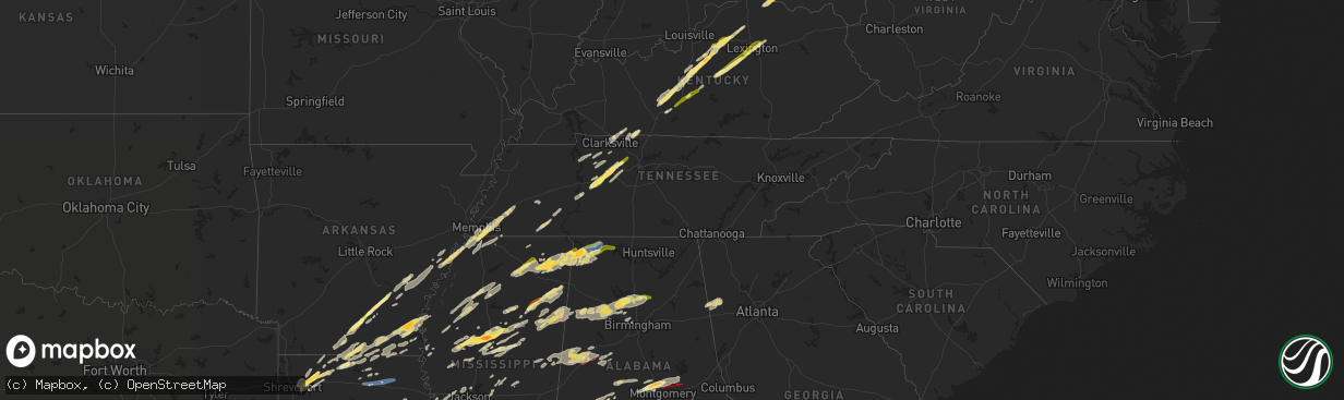
Hail Map in Tennessee on November 29, 2022
The weather event in Tennessee on November 29, 2022 includes Hail, Wind, and Tornado maps. 9 states and 531 cities were impacted and suffered possible damage. The total estimated number of properties impacted is 26,594.
Want more than just the map?
Turn this storm into a full workflow.
- Owner + property data so you know who to knock
- OnDemand branded weather history reports to win the "did we even have hail?" argument
- RoofTrace estimate so reps stop guessing numbers at the door
Bought this map? Upgrade within 7 days and we'll credit the $230. (10-15 min setup call)
Hail
Wind
Tornado
26,594
Estimated number of impacted properties by a 1.00" hail or larger758
Estimated number of impacted properties by a 1.75" hail or larger0
Estimated number of impacted properties by a 2.50" hail or largerStorm reports in Tennessee
Tennessee
| Date | Description |
|---|---|
| 11/29/20225:56 PM CST | Photo from newschannel5 showed spiky hail up to near golf ball size in dickson. |
| 11/29/20225:50 PM CST | Quarter size hail reported on lucas drive southwest of dickson. Report via social media. |
| 11/29/20222:06 AM CST | At 805 PM CST, a severe thunderstorm was located near Dancyville, or near Brownsville, moving northeast at 60 mph. HAZARD...Quarter size hail. SOURCE...Radar indicated. IMPACT...Damage to vehicles is expected. Locations impacted include... Jackson, Brownsville, Humboldt, Fairview, Alamo, Bells, Three Way, Hillville, Bemis, Belle Eagle, Holly Grove, Adair, Dancyville, Mercer, Carroll, Mason, Gadsden, Stanton, Neely and Yum Yum. |
| 11/29/20221:36 AM CST | At 735 PM CST, a severe thunderstorm was located over Eads, or near Cordova, moving northeast at 60 mph. HAZARD...60 mph wind gusts and quarter size hail. SOURCE...Radar indicated. IMPACT...Hail damage to vehicles is expected. Expect wind damage to roofs, siding, and trees. Locations impacted include... Bartlett, Collierville, Brownsville, Bolivar, Cordova, Lakeland, Arlington, Whiteville, Somerville, Hillville, Belle Eagle, Holly Grove, Eads, Dancyville, Cloverport, Mercer, Warren, Macon, Oakland and Mason. |
| 11/29/202212:06 AM CST | At 606 PM CST, a severe thunderstorm was located over White Bluff, or 10 miles northeast of Dickson, moving northeast at 65 mph. HAZARD...60 mph wind gusts and half dollar size hail. SOURCE...Radar indicated. IMPACT...Hail damage to vehicles is expected. Expect wind damage to roofs, siding, and trees. Locations impacted include... Springfield, Ashland City, Hendersonville, Goodlettsville, Millersville, Greenbrier, Coopertown, White Bluff, Kingston Springs, Pegram, Ridgetop, Joelton, Pleasant View, Charlotte, Whites Creek and Beaman Park.This includes the following highways... Interstate 65 between mile markers 95 and 105. Interstate 24 between mile markers 23 and 42. |
| 11/28/202211:45 PM CST | At 545 PM CST, a severe thunderstorm was located 8 miles northwest of Centerville, moving northeast at 65 mph. HAZARD...60 mph wind gusts and half dollar size hail. SOURCE...Radar indicated. IMPACT...Hail damage to vehicles is expected. Expect wind damage to roofs, siding, and trees. Locations impacted include... Dickson, Centerville, White Bluff, Kingston Springs, Burns, Fairview, Charlotte, Bon Aqua, Pinewood, Lyles, Nunnelly and Bucksnort.This includes the following highways... Interstate 40 between mile markers 149 and 187. Interstate 840 between mile markers 1 and 9. |
| 11/28/20229:28 PM CST | At 328 PM CST, a severe thunderstorm was located near Woodville, or 12 miles west of Scottsboro, moving east at 50 mph. HAZARD...60 mph wind gusts and quarter size hail. SOURCE...Radar indicated. IMPACT...Hail damage to vehicles is expected. Expect wind damage to roofs, siding, and trees. Locations impacted include... Scottsboro, Stevenson, Hollywood, Skyline, Pisgah, Pleasant Groves, Hytop, Paint Rock, Bass and Martintown. |
| 11/28/20228:06 PM CST | Multiple trees across road on hewlett dr. |
| 11/28/20227:51 PM CST | At 151 PM CST, a severe thunderstorm was located near Rogersville, or 16 miles east of Muscle Shoals, moving east at 45 mph. HAZARD...60 mph wind gusts and quarter size hail. SOURCE...Radar indicated. IMPACT...Hail damage to vehicles is expected. Expect wind damage to roofs, siding, and trees. Locations impacted include... Athens, Rogersville, Town Creek, Courtland, Tanner, North Courtland, Anderson, Lester, Good Springs and Cartwright. |
| 11/28/20227:15 PM CST | Quarter size hail near shelby dr and lamar. |
| 11/28/20226:19 PM CST | Quarter size hail reported near bearwallow road and bandy road intersection via social media. |
| 11/28/20226:03 PM CST | Twitter photos showed hail up to half dollar |
| 11/28/20226:03 PM CST | Twitter photos showed hail up to half dollar size on crestview park drive in southern dickson. |
All States Impacted by Hail Map on November 29, 2022
Cities Impacted by Hail Map on November 29, 2022
- Clarkson, KY
- Elizabethtown, KY
- Boston, KY
- Dickson, TN
- McEwen, TN
- Vanleer, TN
- Palmyra, TN
- Erin, TN
- Cumberland City, TN
- Cumberland Furnace, TN
- Campbellsville, KY
- Summersville, KY
- Meridian, MS
- Stonewall, MS
- Enterprise, MS
- Gattman, MS
- Starkville, MS
- Mississippi State, MS
- Millport, AL
- West Point, MS
- Aberdeen, MS
- Caledonia, MS
- Steens, MS
- Vernon, AL
- Sulligent, AL
- Cedarbluff, MS
- Hamilton, MS
- Columbus, MS
- Rossville, TN
- Ridgeland, MS
- Madison, MS
- Warren, AR
- Kingston Springs, TN
- Burns, TN
- Centerville, TN
- Nunnelly, TN
- White Bluff, TN
- Charlotte, TN
- Ashland City, TN
- Bon Aqua, TN
- Lobelville, TN
- Only, TN
- Farmerville, LA
- Hollandale, MS
- Cub Run, KY
- Leitchfield, KY
- Stamping Ground, KY
- Bardstown, KY
- Mount Eden, KY
- Sadieville, KY
- Mammoth Cave, KY
- Bonnieville, KY
- Waddy, KY
- Coxs Creek, KY
- Fairfield, KY
- New Haven, KY
- Sweeden, KY
- Bowling Green, KY
- Shelbyville, KY
- Taylorsville, KY
- Bloomfield, KY
- Munfordville, KY
- Hodgenville, KY
- Upton, KY
- Brownsville, KY
- Frankfort, KY
- Sonora, KY
- Bee Spring, KY
- Hornsby, TN
- Bethel Springs, TN
- Pocahontas, TN
- Selmer, TN
- Middleton, TN
- Hurricane Mills, TN
- Byhalia, MS
- Florence, AL
- Park City, KY
- Rocky Hill, KY
- Oakland, KY
- Smiths Grove, KY
- Nesbit, MS
- Southaven, MS
- Hernando, MS
- Coldwater, MS
- Falmouth, KY
- Georgetown, OH
- Hamersville, OH
- Felicity, OH
- Foster, KY
- Brooksville, KY
- Jackson, TN
- Townley, AL
- Berry, AL
- Hanceville, AL
- Bankston, AL
- Trafford, AL
- Oakman, AL
- Hayden, AL
- Fayette, AL
- Carbon Hill, AL
- Empire, AL
- Locust Fork, AL
- Jasper, AL
- Parrish, AL
- Dora, AL
- Warrior, AL
- Bremen, AL
- Cordova, AL
- Kennedy, AL
- Cullman, AL
- Crane Hill, AL
- Cleveland, AL
- Hamburg, AR
- Bastrop, LA
- Canmer, KY
- Hardyville, KY
- Horse Cave, KY
- Magnolia, KY
- Poplar Grove, AR
- El Dorado, AR
- Junction City, AR
- Ackerman, MS
- Greenwood, MS
- Coila, MS
- Carrollton, MS
- Falkner, MS
- Gravel Switch, KY
- Springfield, KY
- Lebanon, KY
- Harrodsburg, KY
- Nicholasville, KY
- Wilmore, KY
- Perryville, KY
- Mackville, KY
- Versailles, KY
- Saltillo, MS
- Winnsboro, LA
- Delhi, LA
- Scooba, MS
- West, MS
- Grady, AR
- Gould, AR
- Lexa, AR
- Crossett, AR
- Marion, LA
- Huttig, AR
- Morton, MS
- Forest, MS
- Lena, MS
- McCool, MS
- French Camp, MS
- Ethel, MS
- Weir, MS
- Baldwyn, MS
- Dumas, MS
- Booneville, MS
- Stewart, MS
- Saint Francisville, LA
- Angola, LA
- Woodville, MS
- Batchelor, LA
- Lettsworth, LA
- Monterey, LA
- Durant, MS
- Eutaw, AL
- Knoxville, AL
- Fairview, TN
- Lyles, TN
- Big Sandy, TN
- Stewart, TN
- Waverly, TN
- Tennessee Ridge, TN
- Coffeeville, MS
- Oakland, MS
- Water Valley, MS
- Tillatoba, MS
- Arkansas City, AR
- Lillie, LA
- Hermitage, AR
- Strong, AR
- Homer, LA
- Lake Village, AR
- Rohwer, AR
- Summerfield, LA
- Bernice, LA
- Spearsville, LA
- Haynesville, LA
- McGehee, AR
- Greenville, MS
- Dermott, AR
- Benoit, MS
- Monticello, AR
- Montrose, AR
- Chatham, MS
- Oxford, MS
- Pontotoc, MS
- Marietta, MS
- Belmont, MS
- Fulton, MS
- Golden, MS
- Ecru, MS
- Cherokee, AL
- New Site, MS
- Blue Springs, MS
- Muscle Shoals, AL
- Iuka, MS
- New Albany, MS
- Tuscumbia, AL
- Guntown, MS
- Thaxton, MS
- Tupelo, MS
- Etta, MS
- Red Bay, AL
- Tishomingo, MS
- Sheffield, AL
- Russellville, AL
- Dennis, MS
- Leighton, AL
- Myrtle, MS
- Marianna, AR
- Linden, TN
- Moundville, AL
- Greensboro, AL
- Sardis, TN
- Finger, TN
- Reagan, TN
- Enville, TN
- Adamsville, TN
- Kilmichael, MS
- Tibbie, AL
- Uriah, AL
- Fruitdale, AL
- State Line, MS
- Deer Park, AL
- Jackson, AL
- Wagarville, AL
- Gainestown, AL
- Leroy, AL
- Chatom, AL
- Portland, AR
- Parkdale, AR
- Olive Branch, MS
- Banks, AR
- Yazoo City, MS
- Vicksburg, MS
- Carthage, MS
- Hemphill, TX
- Clarksville, TN
- Dumas, AR
- Marvell, AR
- Decatur, MS
- Union, MS
- Conehatta, MS
- Barksdale Afb, LA
- Minden, LA
- Haughton, LA
- Sibley, LA
- Elm Grove, LA
- Doyline, LA
- Athens, LA
- Princeton, LA
- Bossier City, LA
- Jones, AL
- Plantersville, AL
- Marion, AL
- Billingsley, AL
- Selma, AL
- Shuqualak, MS
- De Kalb, MS
- Preston, MS
- Ripley, MS
- Birmingham, AL
- Maben, MS
- Mathiston, MS
- Prairie, MS
- Quinton, AL
- Fosters, AL
- Gordo, AL
- Boligee, AL
- Macon, MS
- Aliceville, AL
- Ralph, AL
- Emelle, AL
- Belzoni, MS
- Tchula, MS
- Prattville, AL
- Downsville, LA
- Southside, TN
- Cunningham, TN
- Olmstead, KY
- Adairville, KY
- Franklin, KY
- Springfield, TN
- Cedar Hill, TN
- Russellville, KY
- Clinton, MS
- Jackson, MS
- Paris, KY
- Lexington, KY
- Lexington, MS
- Cruger, MS
- Vaiden, MS
- Eupora, MS
- Winona, MS
- Sidon, MS
- Pheba, MS
- Silver City, MS
- De Witt, AR
- Ethel, AR
- Gillett, AR
- Holly Grove, AR
- Clarendon, AR
- Saint Charles, AR
- Stuttgart, AR
- Duncanville, AL
- Centreville, AL
- Orrville, AL
- Safford, AL
- Alberta, AL
- Philipp, MS
- Schlater, MS
- Sunflower, MS
- Charleston, MS
- Holcomb, MS
- Cascilla, MS
- Minter City, MS
- Parsons, TN
- Decaturville, TN
- Fruithurst, AL
- Rockmart, GA
- Muscadine, AL
- Tallapoosa, GA
- Cedartown, GA
- Buchanan, GA
- Stanton, TN
- Robinsonville, MS
- West Helena, AR
- Helena, AR
- Germantown, TN
- Eads, TN
- Memphis, TN
- Tunica, MS
- Collierville, TN
- Cordova, TN
- Oakland, TN
- Dundee, MS
- Mason, TN
- Horn Lake, MS
- Lake Cormorant, MS
- Walls, MS
- Somerville, TN
- Arlington, TN
- Monroe, LA
- Sterlington, LA
- Vardaman, MS
- Calhoun City, MS
- Gore Springs, MS
- Walnut Grove, MS
- Guthrie, KY
- Allensville, KY
- Buhl, AL
- Tuscaloosa, AL
- Bay Springs, MS
- Paulding, MS
- Enid, MS
- Utica, MS
- Edwards, MS
- Seminary, MS
- Richton, MS
- Kelly, LA
- Winnfield, LA
- Goldonna, LA
- Natchitoches, LA
- Atlanta, LA
- Sikes, LA
- Dodson, LA
- Olla, LA
- Grayson, LA
- Columbia, LA
- Tullos, LA
- Robeline, LA
- Provencal, LA
- Nettleton, MS
- Hampton, AR
- Harrell, AR
- Gilbert, LA
- Collins, MS
- Columbia, MS
- Sumrall, MS
- Monticello, MS
- Prentiss, MS
- Bassfield, MS
- Oak Vale, MS
- Carson, MS
- Foxworth, MS
- Jayess, MS
- Almyra, AR
- Gibsland, LA
- Dubberly, LA
- Okolona, MS
- Amory, MS
- Liberty, MS
- Summit, MS
- Smithdale, MS
- Magnolia, MS
- Kosciusko, MS
- Baldwin, LA
- Franklin, LA
- Jeanerette, LA
- Morgan City, LA
- Waynesboro, MS
- Shubuta, MS
- Melvin, AL
- Laurel, MS
- Gilbertown, AL
- Sallis, MS
- Marion Junction, AL
- Thomaston, AL
- Catherine, AL
- Mccomb, MS
- Toxey, AL
- Silas, AL
- Quitman, MS
- Needham, AL
- Star City, AR
- New Edinburg, AR
- Rison, AR
- Many, LA
- Belmont, LA
- Zwolle, LA
- Marthaville, LA
- Centreville, MS
- Bogue Chitto, MS
- Gloster, MS
- Ruth, MS
- Heflin, LA
- Huntington, TX
- Goodman, MS
- Louisville, MS
- Ellisville, MS
- Cotton Valley, LA
- Adamsville, AL
- Graysville, AL
- Mantee, MS
- Woodland, MS
- Houston, MS
- Smithville, MS
- Tremont, MS
- Carriere, MS
- Poplarville, MS
- Bogalusa, LA
- West Monroe, LA
- Benton, MS
- Pickens, MS
- Ruleville, MS
- Courtland, MS
- Pope, MS
- Tutwiler, MS
- Drew, MS
- Louann, AR
- Yorktown, AR
- Greensburg, LA
- Brent, AL
- Altheimer, AR
- Itta Bena, MS
- Petal, MS
- Bolton, MS
- Sweet Water, AL
- Linden, AL
- Milam, TX
- Broaddus, TX
- San Augustine, TX
- Noble, LA
- Bronson, TX
- Indianola, MS
- Pelahatchie, MS
- Wisner, LA
- Franklinton, LA
- Sandy Hook, MS
- Angie, LA
- Tylertown, MS
- Glen Allan, MS
- Wetumpka, AL
- Autaugaville, AL
- Coosada, AL
- Deatsville, AL
- Millbrook, AL
- Elmore, AL
- Hattiesburg, MS
- Pleasant Hill, LA
- Fort Necessity, LA
- Zavalla, TX
- Montgomery, LA
- Georgetown, LA
- Campti, LA
- Newellton, LA
- Etoile, TX
- Dubach, LA
- Perkinston, MS
- Booth, AL
- Lowndesboro, AL
- Montgomery, AL
- Eclectic, AL
- Tallassee, AL
- Wilmot, AR
- Hollywood, AL
- Cave City, KY
- Adams, TN
- Scottsboro, AL
- Fackler, AL
- Joelton, TN
- Calhoun, LA
- Oak Ridge, LA
- Collinston, LA
- Rayville, LA
- Killen, AL
- Blue Mountain, MS
- Town Creek, AL
- Athens, AL
- Rogersville, AL
- Oneonta, AL
- Greensburg, KY
- Salvisa, KY
- Lawrenceburg, KY
- Bagdad, KY
- Oberlin, LA
- Heidelberg, MS
- Stringer, MS
- Akron, AL
- Newhebron, MS
- Magee, MS


