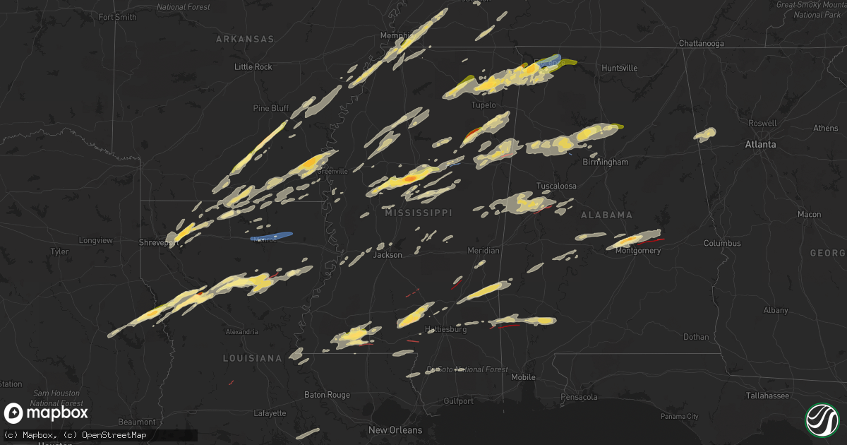
Hail Map in Mississippi on November 29, 2022
Get this storm
November 29 map
$229
one time, instant access
Download today. No call, no setup
Keep the $229
Bought the map and want the full workflow? Apply the entire $229 to a subscription within 7 days. None of it is wasted.
Every map, not just this one
This buys you this map. Subscription and you get every map we run, in the markets you choose from a few cities to whole states to nationwide. Plus real-time alerts the moment a storm fires.
Contact data
Name, contact info, occupancy, even credit band for addresses in the footprint. You go from where it hit to who to call.
Become the source they trust
Unlimited branding weather history reports on demand. You already have the documented answer ready for the property owner, and you are the one who showed up with it.
Property data and RoofTrace estimates
Pull up any address you have got, its value and the exact code rules for that jurisdiction, straight from One Click Code. Then RoofTrace estimates the squares, pitch, and roof value, priced the way you price.
Storm reports in Mississippi
Mississippi
| Date | Description |
|---|---|
| 11/29/20225:45 PM CST | Tree downed on house from confirmed tornado. |
| 11/29/20225:21 PM CST | This corrects the previous report of thunderstorm wind damage from 5 w chester. Tree down on natchez trace pkwy blocking both directions. Just south of us-82... In webs |
| 11/29/20225:16 PM CST | Tree down on natchez trace pkwy blocking both directions. Just south of us-82... Still in webster county. Report from spotternetwork. |
| 11/29/20225:16 PM CST | Trees downed. |
| 11/29/20225:16 PM CST | Reports of transformer on fire and multiple trees downed as well as a few power poles snapped. |
| 11/29/20225:16 PM CST | Reported damage to news room from confirmed tornado. |
| 11/29/20225:16 PM CST | Storm chasers observed and recorded a large wedge tornado on hwy 42 tracking e-se out of bassfield. Several downed trees and power flashes were observed as well. |
| 11/29/20225:15 PM CST | Quarter sized hail reported. |
| 11/29/20225:14 PM CST | Corrects previous tornado report from 4 nne bywy. Tree downed on house from confirmed tornado. |
| 11/29/20225:14 PM CST | This tornado touched down near the intersection of bassfield cemetery road and mcleod dr and tracked ene for almost 4 miles before dissipating just beyond hosey mikell |
| 11/29/20225:11 PM CST | This tornado touched down near the intersection of mississippi highway 9 and maddox road where a few trees were snapped or damaged. The tornado moved northeast and cros |
| 11/29/20225:11 PM CST | Building was damaged and rv was rolled along hester road. |
| 11/29/20225:10 PM CST | Power poles were snapped along hwy 35 s of bassfield... Ms. |
| 11/29/20225:10 PM CST | Trees down reported on gates rd. |
| 11/29/20225:10 PM CST | Corrects previous report: mhp confirmed tornado on hwy 35 marion jeff davis line. |
| 11/29/20225:10 PM CST | Mobile home was damaged. Porch was destroyed and there was damage to a truck on the property. |
| 11/29/20225:08 PM CST | This brief tornado touched down just off ebenezer church road. A few trees were uprooted and damaged. |
| 11/29/20225:05 PM CST | Mhp confirmed tornado on hwy 35 marion jeff davis line. |
| 11/29/20225:05 PM CST | Quarter to golf ball hail in the carson community. |
| 11/29/20224:40 PM CST | Corrects previous tornado report from 2 sw tilton. Reports of tornado. Debris reported with possible structural damage. |
| 11/29/20224:40 PM CST | Reports of tornado. Debris reported with possible structural damage. |
| 11/29/20224:25 PM CST | This tornado touched down near the intersection of tilton road and givens road and moved northeast along tilton road. Most of the damage was uprooted and damaged trees. |
| 11/29/20223:24 PM CST | Tornado was reported northeast of west. |
| 11/29/20223:22 PM CST | Large golf ball size hail was reported near the thompson community. |
| 11/29/20223:20 PM CST | A tree was blown down on mulberry street in vaiden. Transformer was down as well. |
| 11/29/20223:11 PM CST | A tree was reported down near the amite and franklin cos line along hwy 567. |
| 11/29/20223:10 PM CST | Quarter to golf ball hail in and around bassfield. |
| 11/29/20223:06 PM CST | Storm chaser submitted a picture of 2-inch size hail on facebook. |
| 11/29/20222:45 PM CST | 1.25 hail reported in tchula ms. |
| 11/29/20222:33 PM CST | Corrects previous hail report from tchula. Hail report. |
| 11/29/20222:32 PM CST | Corrects previous hail report from tchula. 1.25 hail reported in tchula ms. |
| 11/29/202212:45 PM CST | Several trees down near and around the intersections of highway 30 highway 365. Report of roof damage to a church and a barn south of this intersection. |
| 11/29/202212:42 PM CST | About 50 pine trees were snapped off near the intersection of highway 371 and highway 366 in marietta. All trees were blown to the southeast. |
| 11/29/202212:30 PM CST | Dime to quarter-sized hail. |
| 11/29/202212:23 PM CST | Corrects previous tstm wnd dmg report time from marietta. About 50 pine trees were snapped off near the intersection of highway 371 and highway 366 in marietta. All tre |
| 11/29/202212:12 PM CST | Trees down on structure. Twitter report. |
| 11/29/202212:08 PM CST | Roof partially removed from house on county road 5141 south of booneville. Time is radar estimated. |
| 11/29/202212:00 PM CST | Two inch hail fell in the carolina community. |
| 11/29/202211:40 AM CST | A local report indicates 1.00 inch wind near 1 E NEW ALBANY |
| 11/29/20226:55 AM CST | At 1254 PM CST, a severe thunderstorm was located over Indianola, moving northeast at 65 mph. HAZARD...60 mph wind gusts and quarter size hail. SOURCE...Radar indicated. IMPACT...Hail damage to vehicles is expected. Expect wind damage to roofs, siding, and trees. This severe thunderstorm will be near... Sunflower and Blaine around 105 PM CST. Minter City and Sunnyside around 120 PM CST.Other locations impacted by this severe thunderstorm include Schlaterand Doddsville. |
| 11/29/20225:30 AM CST | At 1130 AM CST, a severe thunderstorm was located over New Albany, moving northeast at 40 mph. HAZARD...60 mph wind gusts and quarter size hail. SOURCE...Radar indicated. IMPACT...Hail damage to vehicles is expected. Expect wind damage to roofs, siding, and trees. Locations impacted include... Booneville, New Albany, Ripley, Baldwyn, Jumpertown, Keownville, Wheeler, Myrtle, Dumas, Shari, Poolville, Graham, Jericho, Branyan, Ellistown, Old Myrtle, Collinstown, Pumpkin Center, Baker and Geeville. |
| 11/29/20225:14 AM CST | At 1113 PM CST, a severe thunderstorm was located near Liberty, moving east at 40 mph. HAZARD...60 mph wind gusts and quarter size hail. SOURCE...Radar indicated. IMPACT...Hail damage to vehicles is expected. Expect wind damage to roofs, siding, and trees. Locations impacted include... Liberty. |
| 11/29/20225:13 AM CST | At 1113 PM CST, a severe thunderstorm was located 10 miles south of Cherokee, moving east at 45 mph. HAZARD...60 mph wind gusts. SOURCE...Radar indicated. IMPACT...Expect damage to roofs, siding, and trees. Locations impacted include... Florence, Muscle Shoals, Russellville, Sheffield, Tuscumbia, Red Bay, Phil Campbell, Killen, Town Creek and Cherokee. |
| 11/29/20225:11 AM CST | At 1110 AM CST, a severe thunderstorm was located near Montpelier, moving northeast at 50 mph. HAZARD...60 mph wind gusts and quarter size hail. SOURCE...Radar indicated. IMPACT...Hail damage to vehicles is expected. Expect wind damage to roofs, siding, and trees. Locations impacted include... Aberdeen, Houston, Okolona, Prairie, Trebloc, Woodland, Sparta, Van Vleet, Parkersburg, Egypt, Tabbville, McCondy, Anchor, Buena Vista and Leotis. |
| 11/29/20224:26 AM CST | At 1025 PM CST, a severe thunderstorm was located over Baldwyn, moving east at 50 mph. HAZARD...60 mph wind gusts and quarter size hail. SOURCE...Radar indicated. IMPACT...Hail damage to vehicles is expected. Expect wind damage to roofs, siding, and trees. Locations impacted include... Baldwyn, Tishomingo State Park, Saltillo, Guntown, Belmont, Tishomingo, Burton, Wheeler, Pratts Friendship, Sandy Springs, Blair, Marietta, Blue Springs, Golden, Paden, Graham, Thrasher, Jericho, Branyan and Dennis. |
| 11/29/20224:14 AM CST | At 1013 PM CST, a severe thunderstorm was located 8 miles west of Wakefield, or 9 miles northwest of St. Francisville, moving east at 40 mph. HAZARD...60 mph wind gusts and quarter size hail. SOURCE...Radar indicated. IMPACT...Hail damage to vehicles is expected. Expect wind damage to roofs, siding, and trees. Locations impacted include... Wakefield and Spillman. |
| 11/29/20224:09 AM CST | At 1009 AM CST, a severe thunderstorm was located over Charleston, moving northeast at 45 mph. HAZARD...60 mph wind gusts and quarter size hail. SOURCE...Radar indicated. IMPACT...Hail damage to vehicles is expected. Expect wind damage to roofs, siding, and trees. Locations impacted include... Water Valley, Charleston, George Payne State Park, Coffeeville, Pope, Springdale, Enid, Paynes, Velma, Scobey, Oakland, Courtland, Shuford, Pine Valley, Tillatoba and Eureka Springs. |
| 11/29/20223:58 AM CST | At 958 PM CST, a severe thunderstorm was located near Mcmillan, or 8 miles northwest of Louisville, moving northeast at 50 mph. HAZARD...60 mph wind gusts and quarter size hail. SOURCE...Radar indicated. IMPACT...Hail damage to vehicles is expected. Expect wind damage to roofs, siding, and trees. This severe thunderstorm will be near... Craig Springs around 1015 PM CST. Longview around 1020 PM CST. Starkville and Oktoc around 1025 PM CST. Sessums around 1035 PM CST. Bent Oak around 1045 PM CST.Other locations impacted by this severe thunderstorm include Sturgisand Artesia. |
| 11/29/20223:50 AM CST | At 949 PM CST, a severe thunderstorm was located near Fort Adams, or 16 miles north of St. Francisville, moving northeast at 45 mph. HAZARD...60 mph wind gusts and quarter size hail. SOURCE...Radar indicated. IMPACT...Hail damage to vehicles is expected. Expect wind damage to roofs, siding, and trees. Locations impacted include... Centreville, Woodville, Fort Adams and Crosby. |
| 11/29/20223:00 AM CST | At 900 PM CST, a severe thunderstorm was located near Prospect, moving northeast at 45 mph. HAZARD...60 mph wind gusts and quarter size hail. SOURCE...Radar indicated. IMPACT...Hail damage to vehicles is expected. Expect wind damage to roofs, siding, and trees. This severe thunderstorm will be near... Neshoba around 910 PM CST. Little Rock around 915 PM CST. House, Herbert Springs and Bethsaida around 920 PM CST. Damascus and Forestdale around 930 PM CST. Liberty around 935 PM CST. Bluff Springs around 940 PM CST. De Kalb around 945 PM CST.Other locations impacted by this severe thunderstorm include Tucker. |
| 11/29/20222:29 AM CST | Damage to trees along highway 57 to the south of johnson creek baptist church. |
| 11/29/20222:27 AM CST | The tornado began near hwy 57 in greene county ms where several softwood tree trunks were snapped... Then took a northeast track producing damage along nursery road. Th |
| 11/29/20221:53 AM CST | An ice skating rink canopy and concert stage was damaged in downtown columbia and a large christmas tree was downed at bluff street park. |
| 11/29/20221:51 AM CST | This brief tornado touched down just north of ten mile creek road in southern marion county where it initially produced minor damage in a stand of trees. An outbuilding |
| 11/29/20221:25 AM CST | Sherriffs office report trees down across county. |
| 11/29/20221:06 AM CST | At 706 PM CST, a cluster of severe thunderstorms were located over Walls, or near Horn Lake, moving northeast at 60 mph. HAZARD...Quarter size hail. SOURCE...Radar indicated. IMPACT...Damage to vehicles is expected. Locations impacted include... Bartlett, Southaven, Collierville, Germantown, Olive Branch, Horn Lake, Hernando, T O Fuller State Park, Cordova, Memphis, Lakeland, Arlington, Walls, Horseshoe Lake, Lake Cormorant, Southwest Memphis, Ellendale, Eudora, Lewisburg and Whitehaven. |
| 11/29/202212:54 AM CST | Spotter reports tree damage along i-55 south of magnolia. |
| 11/29/202212:42 AM CST | An ef1 tornado with maximum winds of 100 mph and a maximum width of 250 yards touched down on pilgrims rest road southeast of liberty... Ms and ended on centerville roa |
| 11/29/202212:40 AM CST | At 640 PM CST, a severe thunderstorm was located over Goshen Springs, or 11 miles southeast of Canton, moving east at 55 mph. HAZARD...Ping pong ball size hail and 60 mph wind gusts. SOURCE...Radar indicated. IMPACT...People and animals outdoors will be injured. Expect hail damage to roofs, siding, windows, and vehicles. Expect wind damage to roofs, siding, and trees. This severe thunderstorm will be near... Leesburg and Farmhaven around 650 PM CST. Ludlow and Forkville around 655 PM CST. Tuscola around 705 PM CST. Edinburg, Dowdville and Madden around 720 PM CST. Pearl River and Dixon around 725 PM CST. Philadelphia around 730 PM CST.Other locations impacted by this severe thunderstorm include Lena,Walnut Grove, Sebastopol and Standing Pine. |
| 11/29/202212:12 AM CST | At 612 PM CST, a severe thunderstorm was located near Pocahontas, or near Clinton, moving northeast at 45 mph. HAZARD...60 mph wind gusts and half dollar size hail. SOURCE...Radar indicated. IMPACT...Hail damage to vehicles is expected. Expect wind damage to roofs, siding, and trees. This severe thunderstorm will be near... Ridgeland and Annandale around 620 PM CST. Madison and Gluckstadt around 625 PM CST. Canton around 630 PM CST. Fannin around 635 PM CST. Goshen Springs and Pisgah around 640 PM CST. Sharon around 645 PM CST. Ludlow and Farmhaven around 655 PM CST. |
| 11/28/202211:45 PM CST | At 544 PM CST, a severe thunderstorm was located over Arkansas City, or 12 miles south of Rohwer, moving northeast at 50 mph. HAZARD...60 mph wind gusts and quarter size hail. SOURCE...Radar indicated. IMPACT...Hail damage to vehicles is expected. Expect wind damage to roofs, siding, and trees. Locations impacted include... Arkansas City... Lucca Landing... Jersey Point... McGehee... Masonville... Halley... |
| 11/28/202211:28 PM CST | Trees and branches down in the area. |
| 11/28/202211:27 PM CST | At 527 PM CST, a severe thunderstorm was located over Kolola Springs, or near Columbus AFB, moving east at 35 mph. HAZARD...Ping pong ball size hail and 60 mph wind gusts. SOURCE...Radar indicated. IMPACT...People and animals outdoors will be injured. Expect hail damage to roofs, siding, windows, and vehicles. Expect wind damage to roofs, siding, and trees. This severe thunderstorm will be near... Caledonia around 535 PM CST. |
| 11/28/202211:07 PM CST | Roof blown off house. |
| 11/28/202211:02 PM CST | At 502 PM CST, a severe thunderstorm was located near Ladelle, or 13 miles northeast of Hamburg, moving northeast at 45 mph. HAZARD...60 mph wind gusts and quarter size hail. SOURCE...Radar indicated. IMPACT...Hail damage to vehicles is expected. Expect wind damage to roofs, siding, and trees. Locations impacted include... Dermott... Rohwer... Arkansas City... Tillar... Watson... Jersey Point... Lucca Landing... McGehee... Kelso... Prairie Grove... Jerome... Baxter... Halley... Masonville... Collins... McArthur... |
| 11/28/202210:54 PM CST | Tree branches down in the area. |
| 11/28/202210:52 PM CST | Trees and sheet metal down in the area. |
| 11/28/202210:50 PM CST | At 449 PM CST, a severe thunderstorm was located near Kilmichael, or 15 miles east of Winona, moving east at 60 mph. HAZARD...Ping pong ball size hail and 60 mph wind gusts. SOURCE...Radar indicated. IMPACT...People and animals outdoors will be injured. Expect hail damage to roofs, siding, windows, and vehicles. Expect wind damage to roofs, siding, and trees. This severe thunderstorm will be near... Eupora around 500 PM CST. Chester around 505 PM CST. Mathiston, Sherwood and Reform around 510 PM CST. Maben around 515 PM CST. Pheba around 520 PM CST. Starkville and Longview around 525 PM CST. Muldrow and Sessums around 535 PM CST.Other locations impacted by this severe thunderstorm includeWalthall. |
| 11/28/202210:45 PM CST | Trees and branches down in the area. |
| 11/28/202210:40 PM CST | Possible tornado damage off mount zion road. Barn damaged. |
| 11/28/202210:37 PM CST | Tree branches down in the area. |
| 11/28/202210:30 PM CST | Golf ball size hail reported by fire dept near baldywn. |
| 11/28/202210:30 PM CST | Tweet from kim gray. |
| 11/28/202210:26 PM CST | Report from mping: 1-inch tree limbs broken; shingles blown off. |
| 11/28/202210:10 PM CST | At 409 PM CST, a severe thunderstorm was located over Black Hawk, moving northeast at 60 mph. HAZARD...60 mph wind gusts and quarter size hail. SOURCE...Radar indicated. IMPACT...Hail damage to vehicles is expected. Expect wind damage to roofs, siding, and trees. This severe thunderstorm will be near... Coila around 415 PM CST. North Carrollton around 425 PM CST. Winona around 430 PM CST. Duck Hill around 440 PM CST. Sweatman and Lodi around 445 PM CST. Misterton around 450 PM CST.Other locations impacted by this severe thunderstorm includeCarrollton. |
| 11/28/202210:09 PM CST | At 409 PM CST, a severe thunderstorm was located over Jayess, or 15 miles northwest of Kokomo, moving east at 35 mph. HAZARD...60 mph wind gusts and quarter size hail. SOURCE...Radar indicated. IMPACT...Hail damage to vehicles is expected. Expect wind damage to roofs, siding, and trees. This severe thunderstorm will be near... Holly Springs and Tilton around 425 PM CST. Oak Vale and Morgantown around 430 PM CST. Goss around 435 PM CST. Society Hill around 440 PM CST. Bunker Hill around 445 PM CST. Carson around 450 PM CST. Melba around 500 PM CST.Other locations impacted by this severe thunderstorm includeBassfield. |
| 11/28/202210:00 PM CST | Four power poles downed in the inverness area. |
| 11/28/20229:38 PM CST | At 337 PM CST, a severe thunderstorm was located over Summit, or over Mccomb, moving east at 35 mph. HAZARD...60 mph wind gusts and quarter size hail. SOURCE...Radar indicated. IMPACT...Hail damage to vehicles is expected. Expect wind damage to roofs, siding, and trees. Locations impacted include... Mccomb and Summit. This includes Interstate 55 in Mississippi between mile markers 15and 24. |
| 11/28/20229:21 PM CST | Power pole down reported by ema. |
| 11/28/20229:14 PM CST | Trees down near huddleston road and hwy 494. |
| 11/28/20229:14 PM CST | At 314 PM CST, a severe thunderstorm was located near Embry, or 20 miles northeast of Winona, moving northeast at 50 mph. HAZARD...60 mph wind gusts and quarter size hail. SOURCE...Radar indicated. IMPACT...Hail damage to vehicles is expected. Expect wind damage to roofs, siding, and trees. Locations impacted include... Houston, Calhoun City, Vardaman, Derma, Slate Springs, Sabougla, Pyland, Woodland, Sparta, Thorn, Thelma, Tabbville, Anchor, Atlanta, Dentontown, Slate Spring and Loyd. |
| 11/28/20229:02 PM CST | At 302 PM CST, a severe thunderstorm was located over Panther Burn, or near Hollandale, moving northeast at 60 mph. HAZARD...60 mph wind gusts and half dollar size hail. SOURCE...Radar indicated. IMPACT...Hail damage to vehicles is expected. Expect wind damage to roofs, siding, and trees. This severe thunderstorm will be near... Hollandale and Delta City around 305 PM CST. Murphy and Darlove around 310 PM CST. Isola around 320 PM CST. Belzoni and Inverness around 325 PM CST. Swiftown around 330 PM CST.Other locations impacted by this severe thunderstorm include SilverCity and Morgan City. |
| 11/28/20228:58 PM CST | At 258 PM CST, a severe thunderstorm was located near Smithdale, or 14 miles northwest of Mccomb, moving northeast at 35 mph. HAZARD...60 mph wind gusts and quarter size hail. SOURCE...Radar indicated. IMPACT...Hail damage to vehicles is expected. Expect wind damage to roofs, siding, and trees. This severe thunderstorm will be near... West Lincoln around 315 PM CST. Bogue Chitto around 320 PM CST. Enterprise around 325 PM CST. Brookhaven around 330 PM CST. East Lincoln around 335 PM CST. |
| 11/28/20228:51 PM CST | At 250 PM CST, a severe thunderstorm was located near Winona, moving northeast at 65 mph. HAZARD...60 mph wind gusts and quarter size hail. SOURCE...Radar indicated. IMPACT...Hail damage to vehicles is expected. Expect wind damage to roofs, siding, and trees. This severe thunderstorm will be near... Lodi and Sweatman around 300 PM CST. Eupora, Bellefontaine and Embry around 310 PM CST.Other locations impacted by this severe thunderstorm includeWalthall. |
| 11/28/20228:29 PM CST | Tree downed on hwy 22 and had to be cleared. |
| 11/28/20228:29 PM CST | Corrects previous tornado report from 2 ene brownsville. Tree downed on hwy 22 and had to be cleared. |
| 11/28/20228:09 PM CST | Trees down n williamsburg rd. Also a transformer blew. Possible tornado. |
| 11/28/20227:56 PM CST | Em report of a few trees down across the area. |
| 11/28/20227:48 PM CST | At 148 PM CST, a severe thunderstorm was located over Fort Adams, or 18 miles east of Simmesport, moving northeast at 40 mph. HAZARD...60 mph wind gusts and quarter size hail. SOURCE...Radar indicated. IMPACT...Hail damage to vehicles is expected. Expect wind damage to roofs, siding, and trees. Locations impacted include... Woodville, Gloster, Fort Adams and Crosby. |
| 11/28/20227:45 PM CST | Desoto ema report from public. Quarter size hail at greenbrook parkway and charter oak drive. |
| 11/28/20227:38 PM CST | At 138 PM CST, a severe thunderstorm was located near Tishomingo State Park, moving east at 50 mph. HAZARD...60 mph wind gusts and half dollar size hail. SOURCE...Radar indicated. IMPACT...Hail damage to vehicles is expected. Expect wind damage to roofs, siding, and trees. Locations impacted include... Russellville, Red Bay, Posey Loop, Pogo, Cedar Creek Reservoir, Srygley Church, New Bethel, Maud, Barton and Halltown. |
| 11/28/20227:34 PM CST | This tornado began at sam hill rd and tracked northeast towards highway 45. Several softwood trees were damaged. After it crossed highway 45... The tornado continued to |
| 11/28/20227:29 PM CST | At 129 PM CST, severe thunderstorms were located along a line extending from near Tishomingo to near Belmont to near Sandy Springs, moving east at 45 mph. HAZARD...60 mph wind gusts and quarter size hail. SOURCE...Radar indicated. IMPACT...Hail damage to vehicles is expected. Expect wind damage to roofs, siding, and trees. Locations impacted include... Tishomingo State Park, Belmont, Tishomingo, Sandy Springs, Golden, Paden, Mingo, Dennis, Moores Mill, Petertown, Neil and Carter Branch. |
| 11/28/20226:49 PM CST | This tornado began along bethany ebenezer road and tracked to the north and east across northwestern winston county. The tornado mainly produced damage to softwood and |
| 11/28/20226:36 PM CST | Doors blown out of station two fire dept. Building. Roof also caved in with outside structural damage. |
| 11/28/20226:36 PM CST | Reports of property damage and people entrapped in malones grocery. |
| 11/28/20226:33 PM CST | Tree and power line damage reported. |
| 11/28/20226:33 PM CST | Trees/powerlines downed and huge metal roof in middle of road. |
| 11/28/20226:33 PM CST | Trees/power lines downed and damage to several homes. |
| 11/28/20226:33 PM CST | Trees/powerlines downed and huge metal roof in middle of road. |
| 11/28/20226:30 PM CST | This tornado touched down se of stringer near county roads 195... 19 and 193. Damage to trees was mostly noted here along with two homes having minor roof damage. Along |
| 11/28/20226:30 PM CST | Damage to home from radar confirmed tornado. |
| 11/28/20226:28 PM CST | Damage to church... Steeple knocked off. |
| 11/28/20226:26 PM CST | At around 6:26pm a severe storm produced a tornado just northwest of the city steens. The tornado initially touched down in a field just west of caledonia steens road. |
| 11/28/20226:25 PM CST | Pictures captured on social media show possible tornado damage at the mt. Zion presbyterian church at the intersection of neilson rd and wolfe rd ne of columbus ms. |
| 11/28/20226:20 PM CST | Sherriffs office have reported downed trees in the county. |
| 11/28/20226:15 PM CST | Large tree was blown down 3 miles ne of kosciusko that blocked off highway 12. |
| 11/28/20226:14 PM CST | Several quarter size hailstones reported by convenience employees. |
| 11/28/20226:00 PM CST | Corrects previous tstm wnd dmg report from 2 ene brownsville. Corrects previous tornado report from 2 ene brownsville. Tree downed on hwy 22 and had to be cleared. |
All States Impacted by Hail Map on November 29, 2022
Cities Impacted by Hail Map on November 29, 2022
- Clarkson, KY
- Elizabethtown, KY
- Boston, KY
- Dickson, TN
- McEwen, TN
- Vanleer, TN
- Palmyra, TN
- Erin, TN
- Cumberland City, TN
- Cumberland Furnace, TN
- Campbellsville, KY
- Summersville, KY
- Meridian, MS
- Stonewall, MS
- Enterprise, MS
- Gattman, MS
- Starkville, MS
- Mississippi State, MS
- Millport, AL
- West Point, MS
- Aberdeen, MS
- Caledonia, MS
- Steens, MS
- Vernon, AL
- Sulligent, AL
- Cedarbluff, MS
- Hamilton, MS
- Columbus, MS
- Rossville, TN
- Ridgeland, MS
- Madison, MS
- Warren, AR
- Kingston Springs, TN
- Burns, TN
- Centerville, TN
- Nunnelly, TN
- White Bluff, TN
- Charlotte, TN
- Ashland City, TN
- Bon Aqua, TN
- Lobelville, TN
- Only, TN
- Farmerville, LA
- Hollandale, MS
- Cub Run, KY
- Leitchfield, KY
- Stamping Ground, KY
- Bardstown, KY
- Mount Eden, KY
- Sadieville, KY
- Mammoth Cave, KY
- Bonnieville, KY
- Waddy, KY
- Coxs Creek, KY
- Fairfield, KY
- New Haven, KY
- Sweeden, KY
- Bowling Green, KY
- Shelbyville, KY
- Taylorsville, KY
- Bloomfield, KY
- Munfordville, KY
- Hodgenville, KY
- Upton, KY
- Brownsville, KY
- Frankfort, KY
- Sonora, KY
- Bee Spring, KY
- Hornsby, TN
- Bethel Springs, TN
- Pocahontas, TN
- Selmer, TN
- Middleton, TN
- Hurricane Mills, TN
- Byhalia, MS
- Florence, AL
- Park City, KY
- Rocky Hill, KY
- Oakland, KY
- Smiths Grove, KY
- Nesbit, MS
- Southaven, MS
- Hernando, MS
- Coldwater, MS
- Falmouth, KY
- Georgetown, OH
- Hamersville, OH
- Felicity, OH
- Foster, KY
- Brooksville, KY
- Jackson, TN
- Townley, AL
- Berry, AL
- Hanceville, AL
- Bankston, AL
- Trafford, AL
- Oakman, AL
- Hayden, AL
- Fayette, AL
- Carbon Hill, AL
- Empire, AL
- Locust Fork, AL
- Jasper, AL
- Parrish, AL
- Dora, AL
- Warrior, AL
- Bremen, AL
- Cordova, AL
- Kennedy, AL
- Cullman, AL
- Crane Hill, AL
- Cleveland, AL
- Hamburg, AR
- Bastrop, LA
- Canmer, KY
- Hardyville, KY
- Horse Cave, KY
- Magnolia, KY
- Poplar Grove, AR
- El Dorado, AR
- Junction City, AR
- Ackerman, MS
- Greenwood, MS
- Coila, MS
- Carrollton, MS
- Falkner, MS
- Gravel Switch, KY
- Springfield, KY
- Lebanon, KY
- Harrodsburg, KY
- Nicholasville, KY
- Wilmore, KY
- Perryville, KY
- Mackville, KY
- Versailles, KY
- Saltillo, MS
- Winnsboro, LA
- Delhi, LA
- Scooba, MS
- West, MS
- Grady, AR
- Gould, AR
- Lexa, AR
- Crossett, AR
- Marion, LA
- Huttig, AR
- Morton, MS
- Forest, MS
- Lena, MS
- McCool, MS
- French Camp, MS
- Ethel, MS
- Weir, MS
- Baldwyn, MS
- Dumas, MS
- Booneville, MS
- Stewart, MS
- Saint Francisville, LA
- Angola, LA
- Woodville, MS
- Batchelor, LA
- Lettsworth, LA
- Monterey, LA
- Durant, MS
- Eutaw, AL
- Knoxville, AL
- Fairview, TN
- Lyles, TN
- Big Sandy, TN
- Stewart, TN
- Waverly, TN
- Tennessee Ridge, TN
- Coffeeville, MS
- Oakland, MS
- Water Valley, MS
- Tillatoba, MS
- Arkansas City, AR
- Lillie, LA
- Hermitage, AR
- Strong, AR
- Homer, LA
- Lake Village, AR
- Rohwer, AR
- Summerfield, LA
- Bernice, LA
- Spearsville, LA
- Haynesville, LA
- McGehee, AR
- Greenville, MS
- Dermott, AR
- Benoit, MS
- Monticello, AR
- Montrose, AR
- Chatham, MS
- Oxford, MS
- Pontotoc, MS
- Marietta, MS
- Belmont, MS
- Fulton, MS
- Golden, MS
- Ecru, MS
- Cherokee, AL
- New Site, MS
- Blue Springs, MS
- Muscle Shoals, AL
- Iuka, MS
- New Albany, MS
- Tuscumbia, AL
- Guntown, MS
- Thaxton, MS
- Tupelo, MS
- Etta, MS
- Red Bay, AL
- Tishomingo, MS
- Sheffield, AL
- Russellville, AL
- Dennis, MS
- Leighton, AL
- Myrtle, MS
- Marianna, AR
- Linden, TN
- Moundville, AL
- Greensboro, AL
- Sardis, TN
- Finger, TN
- Reagan, TN
- Enville, TN
- Adamsville, TN
- Kilmichael, MS
- Tibbie, AL
- Uriah, AL
- Fruitdale, AL
- State Line, MS
- Deer Park, AL
- Jackson, AL
- Wagarville, AL
- Gainestown, AL
- Leroy, AL
- Chatom, AL
- Portland, AR
- Parkdale, AR
- Olive Branch, MS
- Banks, AR
- Yazoo City, MS
- Vicksburg, MS
- Carthage, MS
- Hemphill, TX
- Clarksville, TN
- Dumas, AR
- Marvell, AR
- Decatur, MS
- Union, MS
- Conehatta, MS
- Barksdale Afb, LA
- Minden, LA
- Haughton, LA
- Sibley, LA
- Elm Grove, LA
- Doyline, LA
- Athens, LA
- Princeton, LA
- Bossier City, LA
- Jones, AL
- Plantersville, AL
- Marion, AL
- Billingsley, AL
- Selma, AL
- Shuqualak, MS
- De Kalb, MS
- Preston, MS
- Ripley, MS
- Birmingham, AL
- Maben, MS
- Mathiston, MS
- Prairie, MS
- Quinton, AL
- Fosters, AL
- Gordo, AL
- Boligee, AL
- Macon, MS
- Aliceville, AL
- Ralph, AL
- Emelle, AL
- Belzoni, MS
- Tchula, MS
- Prattville, AL
- Downsville, LA
- Southside, TN
- Cunningham, TN
- Olmstead, KY
- Adairville, KY
- Franklin, KY
- Springfield, TN
- Cedar Hill, TN
- Russellville, KY
- Clinton, MS
- Jackson, MS
- Paris, KY
- Lexington, KY
- Lexington, MS
- Cruger, MS
- Vaiden, MS
- Eupora, MS
- Winona, MS
- Sidon, MS
- Pheba, MS
- Silver City, MS
- De Witt, AR
- Ethel, AR
- Gillett, AR
- Holly Grove, AR
- Clarendon, AR
- Saint Charles, AR
- Stuttgart, AR
- Duncanville, AL
- Centreville, AL
- Orrville, AL
- Safford, AL
- Alberta, AL
- Philipp, MS
- Schlater, MS
- Sunflower, MS
- Charleston, MS
- Holcomb, MS
- Cascilla, MS
- Minter City, MS
- Parsons, TN
- Decaturville, TN
- Fruithurst, AL
- Rockmart, GA
- Muscadine, AL
- Tallapoosa, GA
- Cedartown, GA
- Buchanan, GA
- Stanton, TN
- Robinsonville, MS
- West Helena, AR
- Helena, AR
- Germantown, TN
- Eads, TN
- Memphis, TN
- Tunica, MS
- Collierville, TN
- Cordova, TN
- Oakland, TN
- Dundee, MS
- Mason, TN
- Horn Lake, MS
- Lake Cormorant, MS
- Walls, MS
- Somerville, TN
- Arlington, TN
- Monroe, LA
- Sterlington, LA
- Vardaman, MS
- Calhoun City, MS
- Gore Springs, MS
- Walnut Grove, MS
- Guthrie, KY
- Allensville, KY
- Buhl, AL
- Tuscaloosa, AL
- Bay Springs, MS
- Paulding, MS
- Enid, MS
- Utica, MS
- Edwards, MS
- Seminary, MS
- Richton, MS
- Kelly, LA
- Winnfield, LA
- Goldonna, LA
- Natchitoches, LA
- Atlanta, LA
- Sikes, LA
- Dodson, LA
- Olla, LA
- Grayson, LA
- Columbia, LA
- Tullos, LA
- Robeline, LA
- Provencal, LA
- Nettleton, MS
- Hampton, AR
- Harrell, AR
- Gilbert, LA
- Collins, MS
- Columbia, MS
- Sumrall, MS
- Monticello, MS
- Prentiss, MS
- Bassfield, MS
- Oak Vale, MS
- Carson, MS
- Foxworth, MS
- Jayess, MS
- Almyra, AR
- Gibsland, LA
- Dubberly, LA
- Okolona, MS
- Amory, MS
- Liberty, MS
- Summit, MS
- Smithdale, MS
- Magnolia, MS
- Kosciusko, MS
- Baldwin, LA
- Franklin, LA
- Jeanerette, LA
- Morgan City, LA
- Waynesboro, MS
- Shubuta, MS
- Melvin, AL
- Laurel, MS
- Gilbertown, AL
- Sallis, MS
- Marion Junction, AL
- Thomaston, AL
- Catherine, AL
- Mccomb, MS
- Toxey, AL
- Silas, AL
- Quitman, MS
- Needham, AL
- Star City, AR
- New Edinburg, AR
- Rison, AR
- Many, LA
- Belmont, LA
- Zwolle, LA
- Marthaville, LA
- Centreville, MS
- Bogue Chitto, MS
- Gloster, MS
- Ruth, MS
- Heflin, LA
- Huntington, TX
- Goodman, MS
- Louisville, MS
- Ellisville, MS
- Cotton Valley, LA
- Adamsville, AL
- Graysville, AL
- Mantee, MS
- Woodland, MS
- Houston, MS
- Smithville, MS
- Tremont, MS
- Carriere, MS
- Poplarville, MS
- Bogalusa, LA
- West Monroe, LA
- Benton, MS
- Pickens, MS
- Ruleville, MS
- Courtland, MS
- Pope, MS
- Tutwiler, MS
- Drew, MS
- Louann, AR
- Yorktown, AR
- Greensburg, LA
- Brent, AL
- Altheimer, AR
- Itta Bena, MS
- Petal, MS
- Bolton, MS
- Sweet Water, AL
- Linden, AL
- Milam, TX
- Broaddus, TX
- San Augustine, TX
- Noble, LA
- Bronson, TX
- Indianola, MS
- Pelahatchie, MS
- Wisner, LA
- Franklinton, LA
- Sandy Hook, MS
- Angie, LA
- Tylertown, MS
- Glen Allan, MS
- Wetumpka, AL
- Autaugaville, AL
- Coosada, AL
- Deatsville, AL
- Millbrook, AL
- Elmore, AL
- Hattiesburg, MS
- Pleasant Hill, LA
- Fort Necessity, LA
- Zavalla, TX
- Montgomery, LA
- Georgetown, LA
- Campti, LA
- Newellton, LA
- Etoile, TX
- Dubach, LA
- Perkinston, MS
- Booth, AL
- Lowndesboro, AL
- Montgomery, AL
- Eclectic, AL
- Tallassee, AL
- Wilmot, AR
- Hollywood, AL
- Cave City, KY
- Adams, TN
- Scottsboro, AL
- Fackler, AL
- Joelton, TN
- Calhoun, LA
- Oak Ridge, LA
- Collinston, LA
- Rayville, LA
- Killen, AL
- Blue Mountain, MS
- Town Creek, AL
- Athens, AL
- Rogersville, AL
- Oneonta, AL
- Greensburg, KY
- Salvisa, KY
- Lawrenceburg, KY
- Bagdad, KY
- Oberlin, LA
- Heidelberg, MS
- Stringer, MS
- Akron, AL
- Newhebron, MS
- Magee, MS


