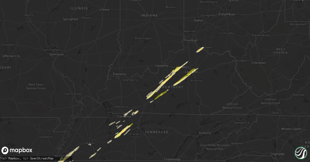
Hail Map in Kentucky on November 29, 2022
Get this storm
November 29 map
$229
one time, instant access
Download today. No call, no setup
Keep the $229
Bought the map and want the full workflow? Apply the entire $229 to a subscription within 7 days. None of it is wasted.
Every map, not just this one
This buys you this map. Subscription and you get every map we run, in the markets you choose from a few cities to whole states to nationwide. Plus real-time alerts the moment a storm fires.
Contact data
Name, contact info, occupancy, even credit band for addresses in the footprint. You go from where it hit to who to call.
Become the source they trust
Unlimited branding weather history reports on demand. You already have the documented answer ready for the property owner, and you are the one who showed up with it.
Property data and RoofTrace estimates
Pull up any address you have got, its value and the exact code rules for that jurisdiction, straight from One Click Code. Then RoofTrace estimates the squares, pitch, and roof value, priced the way you price.
Storm reports in Kentucky
Kentucky
| Date | Description |
|---|---|
| 11/29/20224:28 AM CST | At 1027 PM EST, a severe thunderstorm was located near Felicity, moving northeast at 60 mph. HAZARD...Quarter size hail. SOURCE...Radar indicated. IMPACT...Minor damage to vehicles is possible. Locations impacted include... Georgetown, Mount Orab, Bethel, Williamsburg, Augusta, Sardinia, Felicity, Neville, Russellville, Hamersville, Mowrystown, Higginsport, Chilo, Willow Grove, Bradford, Saltair, Point Isabel, Feesburg and Johnsville. |
| 11/29/20223:11 AM CST | At 910 PM EST, a severe thunderstorm was located over Bryan Station, moving northeast at 60 mph. HAZARD...Quarter size hail. SOURCE...Radar indicated. IMPACT...Damage to vehicles is expected. This severe thunderstorm will be near... Paris around 925 PM EST.Other locations in the path of this severe thunderstorm includeCarlisle. |
| 11/29/20223:04 AM CST | At 904 PM EST, a severe thunderstorm was located 10 miles northwest of Lawrenceburg, moving northeast at 60 mph. HAZARD...Quarter size hail. SOURCE...Radar indicated. IMPACT...Minor damage to vehicles is possible. Locations impacted include... Williamstown, Falmouth, Butler, Morgan, Corinth, Goforth, Browning Corner, Beechwood, Greenwood, Harmony, Cherry Grove, Williamstown Lake, Natlee, Kincaid Lake State Park, Marcus, Keefer, Catawba, Camp Northward, New Columbus and Gene Snyder Airport. |
| 11/29/20223:00 AM CST | At 900 PM EST, a severe thunderstorm was located 8 miles southwest of Frankfort, moving northeast at 50 mph. HAZARD...Quarter size hail. SOURCE...Radar indicated. IMPACT...Damage to vehicles is expected. This severe thunderstorm will be near... Frankfort around 910 PM EST. |
| 11/29/20222:44 AM CST | At 844 PM EST, a severe thunderstorm was located over Harrodsburg, moving northeast at 60 mph. HAZARD...Quarter size hail. SOURCE...Radar indicated. IMPACT...Damage to vehicles is expected. This severe thunderstorm will be near... Nicholasville around 855 PM EST. Dunbar High School around 900 PM EST.Other locations in the path of this severe thunderstorm include ChevyChase, U K Arboretum, Fayette Mall, Veterans Park, Cardinal Hill,Meadowthorpe, Cadentown, Bryan Station, Thoroughbred Acres, Northlandand Highlands. |
| 11/29/20222:43 AM CST | At 843 PM EST, a severe thunderstorm was located over Taylorsville, moving northeast at 60 mph. HAZARD...Quarter size hail. SOURCE...Radar indicated. IMPACT...Damage to vehicles is expected. This severe thunderstorm will remain over mainly rural areas of Spencer, Shelby, northern Nelson and northwestern Franklin Counties, including the following locations... Wakefield, Yoder, Montclair, Waterford, Elmburg, Old Christianburg, Hatton, Hooper, Middletown Heights and Peytona. |
| 11/29/202212:29 AM CST | At 628 PM CST, a severe thunderstorm was located near Joelton, or 9 miles south of Springfield, moving northeast at 65 mph. HAZARD...60 mph wind gusts and quarter size hail. SOURCE...Radar indicated. IMPACT...Hail damage to vehicles is expected. Expect wind damage to roofs, siding, and trees. Locations impacted include... Springfield, Goodlettsville, White House, Millersville, Greenbrier, Coopertown, Ridgetop, Cross Plains, Portland, Joelton, Orlinda, Mitchellville, Oak Grove and Cottontown.This includes the following highways... Interstate 65 between mile markers 99 and 120. Interstate 24 between mile markers 32 and 39. |
| 11/28/202211:48 PM CST | At 548 PM CST, a severe thunderstorm was located near Guthrie, moving northeast at 60 mph. HAZARD...Quarter size hail. SOURCE...Radar indicated. IMPACT...Damage to vehicles is expected. This severe thunderstorm will be near... Russellville around 600 PM CST. |
| 11/28/202211:39 PM CST | At 539 PM CST, a severe thunderstorm was located over Guthrie, or 10 miles northeast of Clarksville, moving northeast at 70 mph. HAZARD...60 mph wind gusts and quarter size hail. SOURCE...Radar indicated. IMPACT...Hail damage to vehicles is expected. Expect wind damage to roofs, siding, and trees. This severe thunderstorm will remain over mainly rural areas of southern Todd County, including the following locations... Allensville. |
| 11/28/20228:15 PM CST | Image of large hail shared with broadcast media on twitter. |
| 11/28/20228:11 PM CST | Numerous reports of quarter size hail in downtown lexington... Relayed by broadcast media. |
| 11/28/20228:08 PM CST | Near henry clay estate... Relayed by broadcast media. |
| 11/28/20228:05 PM CST | Downtown frankfort... Relayed by broadcast media. |
| 11/28/20228:05 PM CST | Beaumont area of lexington... Relayed by broadcast media. |
| 11/28/20227:55 PM CST | Quarter size hail reported by emergency management. |
| 11/28/20227:47 PM CST | A local report indicates 1.00 inch wind near 1 N HARRODSBURG |
| 11/28/20227:31 PM CST | Public report relayed by broadcast media. |
| 11/28/20227:31 PM CST | Image of large hail around ping pong ball size shared by broadcast media. |
| 11/28/20227:22 PM CST | Images of large hail shared by broadcast media on twitter. |
All States Impacted by Hail Map on November 29, 2022
Cities Impacted by Hail Map on November 29, 2022
- Clarkson, KY
- Elizabethtown, KY
- Boston, KY
- Dickson, TN
- McEwen, TN
- Vanleer, TN
- Palmyra, TN
- Erin, TN
- Cumberland City, TN
- Cumberland Furnace, TN
- Campbellsville, KY
- Summersville, KY
- Meridian, MS
- Stonewall, MS
- Enterprise, MS
- Gattman, MS
- Starkville, MS
- Mississippi State, MS
- Millport, AL
- West Point, MS
- Aberdeen, MS
- Caledonia, MS
- Steens, MS
- Vernon, AL
- Sulligent, AL
- Cedarbluff, MS
- Hamilton, MS
- Columbus, MS
- Rossville, TN
- Ridgeland, MS
- Madison, MS
- Warren, AR
- Kingston Springs, TN
- Burns, TN
- Centerville, TN
- Nunnelly, TN
- White Bluff, TN
- Charlotte, TN
- Ashland City, TN
- Bon Aqua, TN
- Lobelville, TN
- Only, TN
- Farmerville, LA
- Hollandale, MS
- Cub Run, KY
- Leitchfield, KY
- Stamping Ground, KY
- Bardstown, KY
- Mount Eden, KY
- Sadieville, KY
- Mammoth Cave, KY
- Bonnieville, KY
- Waddy, KY
- Coxs Creek, KY
- Fairfield, KY
- New Haven, KY
- Sweeden, KY
- Bowling Green, KY
- Shelbyville, KY
- Taylorsville, KY
- Bloomfield, KY
- Munfordville, KY
- Hodgenville, KY
- Upton, KY
- Brownsville, KY
- Frankfort, KY
- Sonora, KY
- Bee Spring, KY
- Hornsby, TN
- Bethel Springs, TN
- Pocahontas, TN
- Selmer, TN
- Middleton, TN
- Hurricane Mills, TN
- Byhalia, MS
- Florence, AL
- Park City, KY
- Rocky Hill, KY
- Oakland, KY
- Smiths Grove, KY
- Nesbit, MS
- Southaven, MS
- Hernando, MS
- Coldwater, MS
- Falmouth, KY
- Georgetown, OH
- Hamersville, OH
- Felicity, OH
- Foster, KY
- Brooksville, KY
- Jackson, TN
- Townley, AL
- Berry, AL
- Hanceville, AL
- Bankston, AL
- Trafford, AL
- Oakman, AL
- Hayden, AL
- Fayette, AL
- Carbon Hill, AL
- Empire, AL
- Locust Fork, AL
- Jasper, AL
- Parrish, AL
- Dora, AL
- Warrior, AL
- Bremen, AL
- Cordova, AL
- Kennedy, AL
- Cullman, AL
- Crane Hill, AL
- Cleveland, AL
- Hamburg, AR
- Bastrop, LA
- Canmer, KY
- Hardyville, KY
- Horse Cave, KY
- Magnolia, KY
- Poplar Grove, AR
- El Dorado, AR
- Junction City, AR
- Ackerman, MS
- Greenwood, MS
- Coila, MS
- Carrollton, MS
- Falkner, MS
- Gravel Switch, KY
- Springfield, KY
- Lebanon, KY
- Harrodsburg, KY
- Nicholasville, KY
- Wilmore, KY
- Perryville, KY
- Mackville, KY
- Versailles, KY
- Saltillo, MS
- Winnsboro, LA
- Delhi, LA
- Scooba, MS
- West, MS
- Grady, AR
- Gould, AR
- Lexa, AR
- Crossett, AR
- Marion, LA
- Huttig, AR
- Morton, MS
- Forest, MS
- Lena, MS
- McCool, MS
- French Camp, MS
- Ethel, MS
- Weir, MS
- Baldwyn, MS
- Dumas, MS
- Booneville, MS
- Stewart, MS
- Saint Francisville, LA
- Angola, LA
- Woodville, MS
- Batchelor, LA
- Lettsworth, LA
- Monterey, LA
- Durant, MS
- Eutaw, AL
- Knoxville, AL
- Fairview, TN
- Lyles, TN
- Big Sandy, TN
- Stewart, TN
- Waverly, TN
- Tennessee Ridge, TN
- Coffeeville, MS
- Oakland, MS
- Water Valley, MS
- Tillatoba, MS
- Arkansas City, AR
- Lillie, LA
- Hermitage, AR
- Strong, AR
- Homer, LA
- Lake Village, AR
- Rohwer, AR
- Summerfield, LA
- Bernice, LA
- Spearsville, LA
- Haynesville, LA
- McGehee, AR
- Greenville, MS
- Dermott, AR
- Benoit, MS
- Monticello, AR
- Montrose, AR
- Chatham, MS
- Oxford, MS
- Pontotoc, MS
- Marietta, MS
- Belmont, MS
- Fulton, MS
- Golden, MS
- Ecru, MS
- Cherokee, AL
- New Site, MS
- Blue Springs, MS
- Muscle Shoals, AL
- Iuka, MS
- New Albany, MS
- Tuscumbia, AL
- Guntown, MS
- Thaxton, MS
- Tupelo, MS
- Etta, MS
- Red Bay, AL
- Tishomingo, MS
- Sheffield, AL
- Russellville, AL
- Dennis, MS
- Leighton, AL
- Myrtle, MS
- Marianna, AR
- Linden, TN
- Moundville, AL
- Greensboro, AL
- Sardis, TN
- Finger, TN
- Reagan, TN
- Enville, TN
- Adamsville, TN
- Kilmichael, MS
- Tibbie, AL
- Uriah, AL
- Fruitdale, AL
- State Line, MS
- Deer Park, AL
- Jackson, AL
- Wagarville, AL
- Gainestown, AL
- Leroy, AL
- Chatom, AL
- Portland, AR
- Parkdale, AR
- Olive Branch, MS
- Banks, AR
- Yazoo City, MS
- Vicksburg, MS
- Carthage, MS
- Hemphill, TX
- Clarksville, TN
- Dumas, AR
- Marvell, AR
- Decatur, MS
- Union, MS
- Conehatta, MS
- Barksdale Afb, LA
- Minden, LA
- Haughton, LA
- Sibley, LA
- Elm Grove, LA
- Doyline, LA
- Athens, LA
- Princeton, LA
- Bossier City, LA
- Jones, AL
- Plantersville, AL
- Marion, AL
- Billingsley, AL
- Selma, AL
- Shuqualak, MS
- De Kalb, MS
- Preston, MS
- Ripley, MS
- Birmingham, AL
- Maben, MS
- Mathiston, MS
- Prairie, MS
- Quinton, AL
- Fosters, AL
- Gordo, AL
- Boligee, AL
- Macon, MS
- Aliceville, AL
- Ralph, AL
- Emelle, AL
- Belzoni, MS
- Tchula, MS
- Prattville, AL
- Downsville, LA
- Southside, TN
- Cunningham, TN
- Olmstead, KY
- Adairville, KY
- Franklin, KY
- Springfield, TN
- Cedar Hill, TN
- Russellville, KY
- Clinton, MS
- Jackson, MS
- Paris, KY
- Lexington, KY
- Lexington, MS
- Cruger, MS
- Vaiden, MS
- Eupora, MS
- Winona, MS
- Sidon, MS
- Pheba, MS
- Silver City, MS
- De Witt, AR
- Ethel, AR
- Gillett, AR
- Holly Grove, AR
- Clarendon, AR
- Saint Charles, AR
- Stuttgart, AR
- Duncanville, AL
- Centreville, AL
- Orrville, AL
- Safford, AL
- Alberta, AL
- Philipp, MS
- Schlater, MS
- Sunflower, MS
- Charleston, MS
- Holcomb, MS
- Cascilla, MS
- Minter City, MS
- Parsons, TN
- Decaturville, TN
- Fruithurst, AL
- Rockmart, GA
- Muscadine, AL
- Tallapoosa, GA
- Cedartown, GA
- Buchanan, GA
- Stanton, TN
- Robinsonville, MS
- West Helena, AR
- Helena, AR
- Germantown, TN
- Eads, TN
- Memphis, TN
- Tunica, MS
- Collierville, TN
- Cordova, TN
- Oakland, TN
- Dundee, MS
- Mason, TN
- Horn Lake, MS
- Lake Cormorant, MS
- Walls, MS
- Somerville, TN
- Arlington, TN
- Monroe, LA
- Sterlington, LA
- Vardaman, MS
- Calhoun City, MS
- Gore Springs, MS
- Walnut Grove, MS
- Guthrie, KY
- Allensville, KY
- Buhl, AL
- Tuscaloosa, AL
- Bay Springs, MS
- Paulding, MS
- Enid, MS
- Utica, MS
- Edwards, MS
- Seminary, MS
- Richton, MS
- Kelly, LA
- Winnfield, LA
- Goldonna, LA
- Natchitoches, LA
- Atlanta, LA
- Sikes, LA
- Dodson, LA
- Olla, LA
- Grayson, LA
- Columbia, LA
- Tullos, LA
- Robeline, LA
- Provencal, LA
- Nettleton, MS
- Hampton, AR
- Harrell, AR
- Gilbert, LA
- Collins, MS
- Columbia, MS
- Sumrall, MS
- Monticello, MS
- Prentiss, MS
- Bassfield, MS
- Oak Vale, MS
- Carson, MS
- Foxworth, MS
- Jayess, MS
- Almyra, AR
- Gibsland, LA
- Dubberly, LA
- Okolona, MS
- Amory, MS
- Liberty, MS
- Summit, MS
- Smithdale, MS
- Magnolia, MS
- Kosciusko, MS
- Baldwin, LA
- Franklin, LA
- Jeanerette, LA
- Morgan City, LA
- Waynesboro, MS
- Shubuta, MS
- Melvin, AL
- Laurel, MS
- Gilbertown, AL
- Sallis, MS
- Marion Junction, AL
- Thomaston, AL
- Catherine, AL
- Mccomb, MS
- Toxey, AL
- Silas, AL
- Quitman, MS
- Needham, AL
- Star City, AR
- New Edinburg, AR
- Rison, AR
- Many, LA
- Belmont, LA
- Zwolle, LA
- Marthaville, LA
- Centreville, MS
- Bogue Chitto, MS
- Gloster, MS
- Ruth, MS
- Heflin, LA
- Huntington, TX
- Goodman, MS
- Louisville, MS
- Ellisville, MS
- Cotton Valley, LA
- Adamsville, AL
- Graysville, AL
- Mantee, MS
- Woodland, MS
- Houston, MS
- Smithville, MS
- Tremont, MS
- Carriere, MS
- Poplarville, MS
- Bogalusa, LA
- West Monroe, LA
- Benton, MS
- Pickens, MS
- Ruleville, MS
- Courtland, MS
- Pope, MS
- Tutwiler, MS
- Drew, MS
- Louann, AR
- Yorktown, AR
- Greensburg, LA
- Brent, AL
- Altheimer, AR
- Itta Bena, MS
- Petal, MS
- Bolton, MS
- Sweet Water, AL
- Linden, AL
- Milam, TX
- Broaddus, TX
- San Augustine, TX
- Noble, LA
- Bronson, TX
- Indianola, MS
- Pelahatchie, MS
- Wisner, LA
- Franklinton, LA
- Sandy Hook, MS
- Angie, LA
- Tylertown, MS
- Glen Allan, MS
- Wetumpka, AL
- Autaugaville, AL
- Coosada, AL
- Deatsville, AL
- Millbrook, AL
- Elmore, AL
- Hattiesburg, MS
- Pleasant Hill, LA
- Fort Necessity, LA
- Zavalla, TX
- Montgomery, LA
- Georgetown, LA
- Campti, LA
- Newellton, LA
- Etoile, TX
- Dubach, LA
- Perkinston, MS
- Booth, AL
- Lowndesboro, AL
- Montgomery, AL
- Eclectic, AL
- Tallassee, AL
- Wilmot, AR
- Hollywood, AL
- Cave City, KY
- Adams, TN
- Scottsboro, AL
- Fackler, AL
- Joelton, TN
- Calhoun, LA
- Oak Ridge, LA
- Collinston, LA
- Rayville, LA
- Killen, AL
- Blue Mountain, MS
- Town Creek, AL
- Athens, AL
- Rogersville, AL
- Oneonta, AL
- Greensburg, KY
- Salvisa, KY
- Lawrenceburg, KY
- Bagdad, KY
- Oberlin, LA
- Heidelberg, MS
- Stringer, MS
- Akron, AL
- Newhebron, MS
- Magee, MS


